Science & Tech

AVO: Eruption likely under way at Alaska volcano

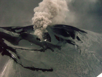
Veniaminof intracaldera cinder cone. Ash plume drifting to NE. Photo taken from a Navajo (Security Aviation) during an observational overflight when the volcano was last active on January 11, 2005. (Photo courtesy of K. L. Wallace and AVO / U.S. Geological Survey)

The Veniaminof Volcano on the Alaska Peninsula is apparently erupting.
Thursday morning the Alaska Volcano Observatory upgraded the volcano alert level for the Veniaminof Volcano to “Watch” due to satellite images that indicate an ongoing eruption.

The Alaska Volcano Observatory has been closely monitoring the Veniaminof Volcano since Saturday when they noticed elevated levels of seismic activity. Chris Waythomas, a geologist with the Alaska Volcano Observatory, confirms that AVO has a seismic network on the volcano but it’s not functioning at 100-percent.

The seismic network is solar powered and some of the stations have apparently not yet come back online due to snow and ice cover. However, Waythomas says that doesn’t account for all the stations.

Mount Veniaminof is an active stratovolcano and it was named after Ivan Popov Veniaminov. He lived from 1797 to 1879 and was a Russian Orthodox missionary priest who is now a saint of the Orthodox Church. He was well known for his writings on the Alaska Native languages. The last time the volcano showed more energetic activity was in 1993 to 1994.

AVO notes that seismic activity similar to the ongoing activity last occurred back in 2005.

Veniaminof has erupted at least 12 times in the past 200 years.

Veniaminof is not the only volcano on the Alaska Peninsula that’s currently in an eruptive state. The Pavlof Volcano to the southwest of Mount Veniaminof is currently at Volcano Alert Level “Watch.”

Waythomas confirms that AVO is still detected elevated seismic activity at Pavlof.

Scientists call for greater protection for Tongass salmon streams

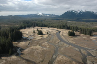
Castle River, Kupreanof Island photo from ShoreZone

A group of scientists is calling on Congress to increase protection for 77 streams on Southeast Alaska’s Tongass National Forest. The effort is called “Tongass 77” and recommends more restrictive land-use designations on nearly two million acres of productive watersheds. A panel representing the scientists held a teleconference on Monday

The coalition of scientists is seeking what’s called a land use designation two, or LUD-II, the most restrictive category on the Tongass besides a wilderness designation, for the 77 fish streams.“Our interest in the land use designation two, which was established in 1990 under the Tongass Timber Reform Act, is to allow a variety of uses but particularly to protect these very important salmon producing watersheds from roads and clear-cut logging that have potentially very long-term impacts on salmon,” explained John Schoen , science advisor emeritus with Audubon Alaska, explained.

“So we envision this protection not as a very strict wilderness designation but a broader designation that really focuses on the conservation of fish and wildlife.”

Audobon Alaska, Trout Unlimited, and 230 individual scientists sent a letter to Congress seeking the change in land use. Jack Williams, senior scientist with Trout Unlimited, said the streams needed more than the 100-foot buffer strips allowed under existing federal management rules. “With the existing rainfall, steep slopes that a lot of these drainages have and experience, the hundred feet just isn’t adequate to really protect these streams, especially if we have timber harvest, road building, those kinds of things, Williams said. “So it’s really this watershed scale to protect these best remaining areas, it just does make the most sense.”

The coalition of scientists identified 77 streams as the most valuable unprotected watersheds on the forest. They argued that salmon should be the top priority for managing Tongass lands.

Heather Hardcastle, a gillnetter who works for Trout Unlimited, said Southeast Alaska and the Tongass had been the most lucrative salmon region in the state for the past two years. She said the health of salmon streams was an important part of that success.

“We still have the opportunity in this region to safeguard those breadbaskets, if you will, or those nurseries for our salmon,” Hardcastle said. “And its been a real honor in the last three years to reach out to commercial fishermen like my family and begin to recognize that there really is a concern out there among all of us that we need to shore up this habitat.”

The group said the watersheds face threats from logging, road building, mining, climate change, hydro electric development and proposed land exchanges and they hope the proposal will be picked up and supported by members of Congress.

Wayne Owen, the director of wildlife, fisheries and watersheds for the Forest Service in Alaska, said the Tongass National Forest is currently reviewing its land management plan. He said the agency welcomes the interest and will take the Tongass 77 proposal into consideration. “The watersheds are in excellent condition,” Owen said. “We feel as though there are adequate protections for salmon in all those streams. That said, the land use designations for the various watersheds that are the Tongass 77 vary from essentially wilderness now to LUDS (land use designations) that are in active timber management.”

Loss of timber management areas is not a popular idea with timber industry. Owen Graham, executive director of the Alaska Forest Association, called the proposal unnecessary and said many of the watersheds listed have no development planned. “There’s buffer strips required on all streams and the Forest Service manages even larger buffer strips than the law requires on many of the streams,” Graham said. “Salmon populations have more than doubled since we started logging here 50-60 years ago so it’s totally unnecessary. What we really need to focus on is restoring a timber supply and timber jobs.”

One member of Alaska’s Congressional delegation has little interest in the Tongass 77 proposal. Congressmen Don Young called it a fundraising tool and said it is “hardly legitimate public policy with any chance of seeing the light of day in Congress while I’m here.”

Meanwhile, Alaska Senator Mark Begich said he’s looking at the proposal and how it fits with another bill to convey some Tongass lands to the Sealaska Regional Native Corporation. “You know this one their point is a good point is you wanna preserve some of these areas, these watersheds for long-term benefit to our fisheries and to the habitat that’s in that region,” Begich said. “So we’re looking at it, we haven’t made any decisions on it but we’re now looking at it as we now know Sealaska is moving forward. They’ve done a lot of work. We’re talking to them about, is it 77, is it 25, is it 92? I don’t know exactly how they got to that number. I know they thought those were the watersheds they thought were most at risk and should be protected. So we’re now talking about how does this fit in with the Sealaska and what does that do to your numbers?”

The 77 watersheds are scattered around Southeast, from Yakutat to the southern end of Prince of Wales Island.

(Rosemarie Alexander at KTOO in Juneau contributed to this report)

The letter from the coalition of scientists can be found here:

New oil spill technology a ‘game changer,’ says CIRCAC

The new disc skimmers have a fuzzy, absorbent coating

A large oil spill in Cook Inlet is the stuff of nightmares for Alaskans who call the area home. One of the organizations dedicated to cleaning up potential spills is CIRCAC, the Cook Inlet Regional Citizens Advisory Council. CIRCAC has a new tool in its clean-up toolbox that it’s calling a “game changer.”
Imagine a disc-shaped device – like a large donut – that’s coated in a soft, fuzzy material. That’s about as good a description as any for oil skimmers – devices that are attached to oil booms for the purpose of soaking up oil in the event of an offshore spill.

Linda Giguere is Public Outreach Director for CIRCAC. She says that oil skimmers have been around for a long time – since before the 1989 Exxon Valdez spill – and have figured prominently in oil spill cleanup all over the world. The problem is that in reality, they just aren’t that efficient.

Giguere says that the industry-standard equipoment, called “Transrecs,” actually pick up as much as 80 percent water to only 20 percent oil, a ratio that some in the oil spill response community were never happy with.

Giguere says the new skimmers have been in development since 2007.

“It started with a lot of research … to find out what manufacturers would be willing to invest in capital and take a risk to build the skimmer that would meet the standards we were looking at,” said Giguere.

It was Eric Haugstad, Tesoro Alaska’s Director of Emergency Response, who took the lead on developing the project. Haugstad pored over catalogues of many different products, eventually finding a company from Gretna, Louisiana, called Crucial, Incorporated. It was Crucial who agreed to develop a new skimmer to meet Alaska’s standards.

With help from the Alaska Department of Environmental Conservation and Cook Inlet Spill Response, Incorporated – or CISPRI – the new skimmers went through many rounds of testing. The new skimmers passed all of the tests with flying colors, says Giguere – even surpassing the highest expectations by collecting as much as 84 percent oil to 16 percent water.

“The response industry is really optimistic that this is going to be … quite a game-changer,” she said.

Giguere says the old-style skimmers will eventually be completely replaced by the new disc skimmers.

CISPRI has already bought two 56‐disc skimmers to pair with two larger response vessels, the Perseverance and Endeavor. They have also purchased five 13‐disc skimmers for near-shore cleanup to be used with two smaller vessels.

Giguere says CIRCAC is in the process of revising oil spill contingency plans and once that is completed, the new oil skimmers will be put into place.

KDLL reporter Shaylon Cochran assisted with this story.

Yakutat’s tern festival in sound and pictures

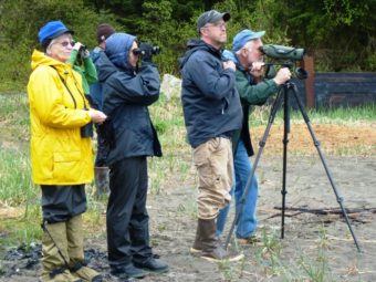
A group of birdwatchers looks for seabirds from Sandy Beach during the Yakutat Tern Festival. Click for a slideshow of festival images. Photo by Ed Schoenfeld, CoastAlaska News.

Birders, biologists, carvers and kids gathered in Yakutat May 30th to June 2nd for the northern Southeast community’s annual tern festival.

The event included lectures, field trips, art classes for kids, a live raptor show, fund-raising meals, Tlingit oratory and a performance from the Mount Saint Elias Dancers.

Here’s an audio post card of the event, which celebrates the return of one variety, the Aleutian tern.

Five Aleutian terns sit on a protected beach on Yakutat’s Black Sand Spit, a nesting area. Photo by Ed Schoenfeld, CoastAlaska News.


Why Chase Tornadoes? To Save Lives, Not To ‘Die Ourselves’

Friday's storm, which produced a mile-wide tornado, as it neared El Reno, Okla. Richard Rowe /Reuters /Landov
Friday’s storm, which produced a mile-wide tornado, as it neared El Reno, Okla. Richard Rowe /Reuters /Landov

The deaths Friday of veteran storm chaser Tim Samaras, his son Paul and their friend Carl Young when a tornado near El Reno, Okla., pummeled their vehicle has raised some questions:

— Why do storm chasers do what they do?

— Do the benefits outweigh the dangers?

Morning Edition has spoken with Josh Wurman, of the Colorado-based Center for Severe Weather Research. He was with a team in the El Reno area on Friday as well.

The people who choose to get close to deadly weather have “a wide variety of motivations,” Wurman says.

There are those who are in it for “the thrill seeking,” much like others who enjoy white water rafting or bungee jumping.

Others may hope to sell videos or photos.

There are those who both enjoy the chase and are fascinated by the science.

And there are those, like the researchers Wurman works with, who have specific missions and are there to study “how tornadoes form, why some tornadoes become strong and some don’t” and hope to collect data that will make the storms easier to predict.

That said, “there’s really no data set which is worth being injured for or dying for,” Wurman says. “Our goal is to help reduce injuries or reduce deaths, not to get injured or die ourselves.”

Wurman doesn’t know why his friend Samaras and the other two men got caught by the tornado on Friday. Wurman’s team had dropped data-collecting equipment in what they thought would be the path of the storm. Then, as they could see on mobile Doppler radar equipment, a second tornado was forming to the south of the main twister. That’s when they decided to move east and out of the area.

It’s possible, he says, that Samaras didn’t realize there was a second tornado in the area. Or, that his escape route was blocked by traffic or something else.

“The storm chasing community and the research community is still absorbing the loss of Tim Samaras, his son and his colleague,” Wurman says.

Wurman’s team and other groups, he’s sure, are evaluating their procedures “and whether or not what we’re doing is safe.”

But as for the reason why to do such work and whether it’s worth it, Wurman says simply that: “If we can make the forecasts better, then fewer people will die.”

More from the conversation with Wurman is scheduled to be on Tuesday’s Morning Edition. We’ll add the as-aired version of the interview to the top of this post after it airs. Click here to find an NPR station that broadcasts or streams the show.

Related stories:

— “Storm Chasers’ Deaths Raise Questions About Practice.” (USA Today)

— “Will Stars’ Death In Okla. Twister Change Storm Chasers Type Shows?” (Fox News)

— “Remembering Tim Samaras: Veteran Storm Chaser Killed In Okla. Tornado.” (ABC News’ Good Morning America)

Copyright 2013 NPR. To see more, visit http://www.npr.org/.
Read original article
Why Chase Tornadoes? To Save Lives, Not To ‘Die Ourselves’

Huge Asteroid Makes Its Closest Pass To Earth Today

Radar images of asteroid 1998 QE2, taken when the cosmic traveler was about 3.75 million miles from Earth, revealed that the asteroid, with a 1.7-mile diameter, has a moon or satellite revolving around it. NASA/JPL-Caltech/GSSR

An asteroid nine times the size of a cruise ship is dropping by Earth on Friday, and it’s not coming alone. Asteroid 1998 QE2 will be about 3.6 million miles from our planet at its closest approach. And its proximity has already given scientists a surprise: It has its own moon, measured at about 2,000 feet wide.

The fly-by will mark the closest the asteroid comes to Earth for at least the next 200 years, according to researchers at NASA’s Jet Propulsion Laboratory who led the radar observations that spotted the asteroid’s moon. The point of maximum proximity will come at 4:59 p.m. ET, or 20:59 UTC, Friday, according to the space agency.

“In the near-Earth population, about 16 percent of asteroids that are about 655 feet (200 meters) or larger are binary or triple systems,” according to NASA. “Radar images suggest that the main body, or primary, is approximately 1.7 miles (2.7 kilometers) in diameter and has a rotation period of less than four hours.”

Unless you can access a powerful telescope, you won’t be able to see the asteroid, much less its lunar tagalong — 1998 QE2 will pass no closer than 15 times the distance between the Earth and its moon. You can watch live video of the asteroid’s passage at Space.com, where a webcast will feature video from the Slooh Space Telescope and the Virtual Telescope Project.

NASA TV hosted a special video on the asteroid Thursday; the agency also recommends the hashtag #asteroidQE2 for those wanting to share thoughts about the asteroid on Twitter.

For amateur astronomers, NASA recommends trying to view the asteroid in the first week of June — particularly June 3 and 4 — when its sunlit side will face the Earth. As for the appearance of 1998 QE2, NASA says it reflects only 6 percent of the light that hits it, making it blacker than coal.

In stories earlier this month announcing the approach, NASA seemed as though it was trying to ease alarmist fears of a cosmic calamity, predicting that the asteroid “will sail serenely past Earth.”

In February, news that a smaller asteroid — 2012 DA14 — was passing by Earth caused a surge of interest, particularly as it came on the heels of a meteor that exploded as it streaked across the sky in Russia.

The 1998 QE2 asteroid was discovered less than 15 years ago, by the Massachusetts Institute of Technology Lincoln Near Earth Asteroid Research (LINEAR) program in New Mexico. The asteroid has not yet been formally named — its current designation reflects a naming convention stemming from its discovery.

While 1998 QE2 has been deemed safe, NASA says it’s keeping an eye out for any possible threats to Earth posed by asteroids. In addition to developing plans to deflect or even possibly ‘shrink-wrap’ an asteroid, the agency is planning a mission to study another asteroid in the coming years.

“In 2016, NASA will launch a robotic probe to one of the most potentially hazardous of the known Near-Earth Objects,” the agency says. “The OSIRIS-REx mission to asteroid (101955) Bennu will be a pathfinder for future spacecraft designed to perform reconnaissance on any newly-discovered threatening objects.”

Copyright 2013 NPR. To see more, visit http://www.npr.org/.image
Read original article
Huge Asteroid Makes Its Closest Pass To Earth Today
Site notifications
Update notification options
Subscribe to notifications