Anna Canny

Local News Reporter

Even flood insurance won’t do much to help homeowners rebuild after Juneau’s record-breaking flood

Aiden Key stands in his backyard along the Mendenhall River. Juneau’s record breaking glacial outburst flood on Aug. 5, 2023 swept away most of his land. He worries that the eroded bank will make his home more vulnerable to future floods. (Anna Canny/KTOO)

Standing at the edge of what used to be a huge, tree-lined backyard along the Mendenhall River, Aiden Key poked at a thick layer of glacial silt with the toe of his boot. 

“A few more of these and you’re looking at beach front property,” he said. “Nice, sandy beaches.”

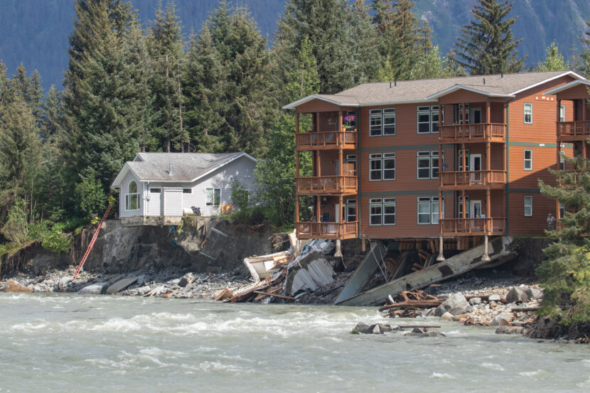
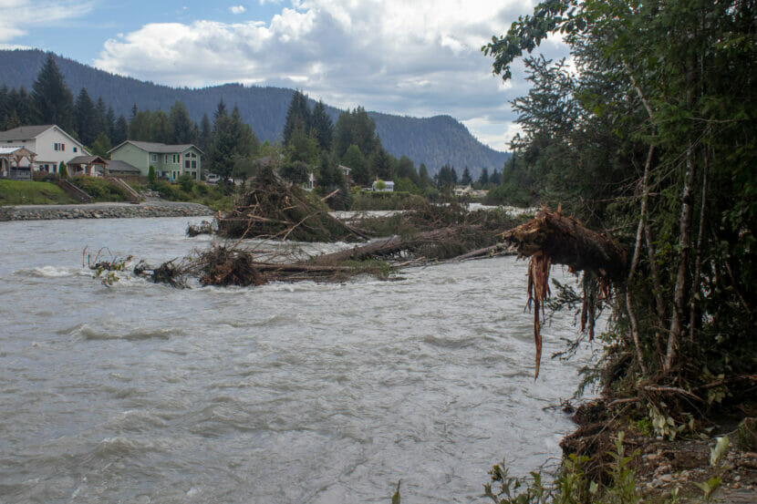
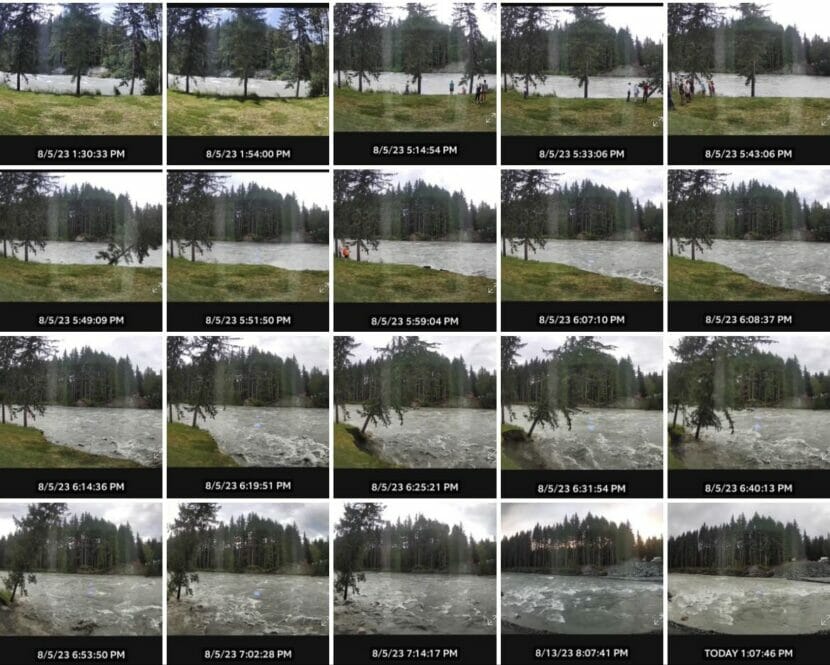
Key says he used to sit on a deck chair and watch bears and porcupines come through his yard. But now those chairs are gone, along with most of the land where that wildlife used to roam. It was all swept away earlier this month in Juneau’s record glacial outburst flood.

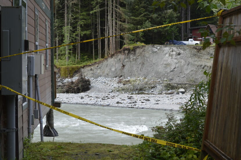
The land that remains is battered. Tree roots stick out from the steep drop off at the edge of the bank. The plants in the garden are wilted, and black landscaping tarp sticks out in patches across the lawn.

Key says he’s been wary of the river ever since he bought the house in 2020. 

“I remember just staring at the river and thinking, wow, that is a force,” he said.

Now, pieces of other houses are propped up against his back porch. They washed up there during the flood. From his yard, Key can see a neighbor’s house hanging off the bank, with one side that’s collapsed.

Houses on River Drive in Juneau, Alaska partially collapsed into to the Mendenhall River during record high water following a glacial outburst flood on Saturday August 5th, 2023. (Mikko Wilson / KTOO)
Houses on River Drive as waters recede from the record glacial outburst flood on Aug. 6, 2023. (Mikko Wilson/KTOO)

There’s no way to fully plan for a disaster like this month’s record glacial outburst flood. But Key — like many others along the river — thought insurance would provide a safety net. He thought wrong.

When he bought the house, he says his insurance agent told him flooding wasn’t something to worry about. He wasn’t in a designated flood zone. But Key bought a flood policy anyway, along with the required homeowner’s policy. 

Now, neither policy will cover the damage from the flood. And he’s worried that the eroded bank has made his house even more vulnerable — and protecting it will likely cost tens of thousands of dollars.

Homeowners insurance excludes Alaska’s most common disasters

The lack of coverage was a surprise to many homeowners like Key. But it’s not a surprise to local insurance agent Emil Mackey. That’s because insurance is designed to protect property — and in insurance terms, that doesn’t necessarily mean what people expect.

“Property is typically a structure or private goods that are on the property, not the land itself,” he said. “That’s where insurance typically stops.”

If Key’s house had been flooded, he might have gotten some money. Since it wasn’t, he’ll get nothing.

Key took the extra precaution of getting flood insurance, but many of his neighbors along the riverbank didn’t. And with a standard homeowners policy, there’s no payout for a disaster like this — no matter how the damage happened. 

Trees piled up in the Mendenhall River after the Aug. 5 glacial outburst flood caused rapid erosion of the river’s banks. (Mikko Wilson/KTOO)

Mackey says that even though homeowners need insurance to get a mortgage, a standard policy won’t cover some of Alaska’s most common disasters — things like earthquakes, avalanches, landslides, floods and all kinds of erosion. 

Because homeowner’s insurance excludes a lot of different things,” Mackey said. “Flood and earth movement are the two big ones that we really need to worry about.”

Those events can cause catastrophic losses, and insurance companies generally want to spread the cost of those losses among many policyholders. Mackey says it’s harder to do that in Alaska. 

“The private market just cannot respond to these risks,” he said. “We’re too small of a state with not enough population to respond to it.”

Riverside homes lacked flood insurance 

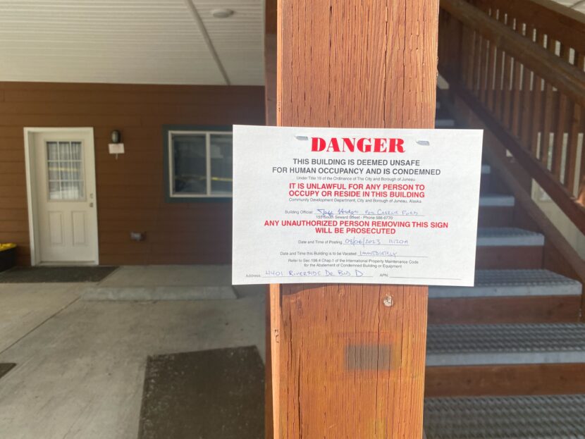
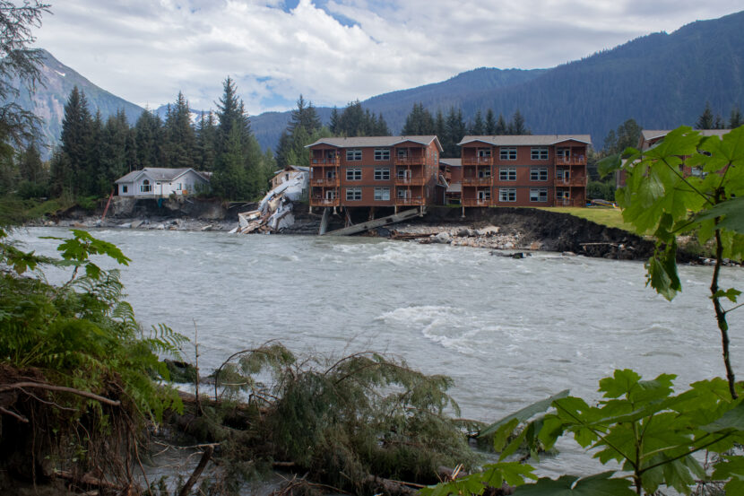
The average Alaska homeowner may not know about all those exclusions. Kris Dorsey’s condo on Riverside Drive was condemned after the flood destroyed its foundation.

She thought that some of the damage might be covered by her homeowner’s insurance policy. 

“In the moment when you’re in the office, signing all the papers, and you’re reading page after page of policy,” Dorsey said. “I think it’s hard to even imagine what’s not in the policy sometimes. Until you have something like this happen.”

In the days after the flood, Dorsey says she spent hours sending emails and making phone calls to her insurance agent. Her adjuster, in Texas, had never even heard of a glacial outburst flood. Eventually, her claim was denied. 

Fallen trees line the banks of the Mendenhall River where flooding eroded land underneath a condo and swept away the house next door. (Katie Anastas/KTOO)

It caught her off guard. 

“I feel like insurance has a responsibility to disclose these things more,” she said. “To make sure customers are aware of exclusions.”

The denial was especially stressful for Dorsey because she won’t get any money for additional living expenses. Dorsey and her family had just ten minutes to pack up and evacuate from their home, leaving many of their belongings behind. They’re not sure when they’ll be able to return. 

Her home insurance policy could offer payments for living expenses — but only for a covered loss. In other words, not for a flood. 

Dorsey didn’t have flood insurance for her condo unit. The building didn’t have it either. Most people purchase flood insurance based on historic flood maps, and the Mendenhall River had never flooded like this before. 

A ring camera on Kris Dorsey’s balcony captured the rapid erosion that undermined her condo buildings foundation. The most severe damage from this year’s glacial outburst flood was caused by erosion, instead of standing water. That’s a gray area for insurance coverage (Photo courtesy of Kris Dorsey)

But even if they had, it still may not have helped. Just like in Key’s back yard, the most severe damage to homes from the flood was caused by eroding river banks, not standing water. Which means it still might not be covered. 

That’s because flood insurance makes exclusions for damage caused by earth movement — things like earthquakes, landslides and erosion. 

Dorsey says she’s not sure if she’ll purchase a flood insurance policy going forward. A couple of days after the flood, a different insurance company reached out to try to sell her flood insurance. 

“And I almost felt like they were trying to trick me into buying something that wouldn’t have worked,” she said. 

You may still want flood insurance

Still, Mackey says he does recommend flood insurance to everyone in Juneau, even outside of historic flood zones. It covers a lot of the gaps left by a regular homeowners policy. For many homes that only have water damage, it should cover the costs of repair. 

While it’s much harder to convince insurers to cover damage from erosion, Mackey says people with flood insurance might get some money by taking their insurance company to court. He says that if erosion happens concurrently with a flood, it may still be covered. 

The remnants of a destroyed house sits between another house and condo buildings in the 4400 block of Riverside Drive left hanging precariously over the Mendenhall River after their foundations were eroded away during record high water from a glacial outburst flood on Saturday August 5th, 2023. (Mikko Wilson / KTOO)
The remnants of a destroyed house beside the condo buildings at 4401 Riverside Drive after the glacial outburst flood on Aug. 5, 2023. (Mikko Wilson/KTOO)

But that won’t be an option for people like Dorsey, who only had a standard homeowners insurance policy. She says she’s overwhelmed by the costs she’s facing for repairs. 

“There’s no way to plan financially for this,” she said.

This fall marks Dorsey’s first season of retirement after nearly thirty years as a teacher. Her husband, who is also a teacher, had hoped to retire, too, at the end of this school year. 

Instead, Dorsey says they might need to pick up extra jobs. 

New Sitka research could help berry pickers adjust to climate change

Slow bluberries
Slow developing blueberries in a Douglas Island yard in early July 2021. (Photo by Matt Miller/KTOO)

Lisa Sadleir-Hart has filled her freezer with berries from her backyard in Sitka for more than 25 years. But this year, that freezer will be emptier. 

“The crop looks terrible,” Sadleir-Hart said. “I hardly have any on my bushes.”

She said her bushes developed differently as spring turned to summer. 

“I noticed that leafing out of the salmonberries seemed to take longer. It happened later,” Sadleir-Hart said. “And then boy, we sure didn’t have the number of flowers and buds that we did last year.”

Scientists and harvesters alike believe that berries have declined in Southeast Alaska in recent years, as human-caused climate change has reshaped the environment. A new project at the Sitka Sound Science Center will closely monitor berry plants throughout the seasons, to help both recreational and subsistence harvesters plan for the future.

In Southeast Alaska, and across the state, climate change is bringing more rainfall, less winter snowfall and hotter temperatures. According to the project’s lead researcher Alex McCarrel, those changes disrupt berry development because a berry plant’s life cycle is precisely tuned to its environment. 

Each stage of development corresponds with the way the weather unfolds throughout the seasons. 

“When the leaves are budding out, or when the flowers are going to be blooming,” McCarrel said. “When can we expect the berries to ripen? Or when is that best week you want to be picking berries.” 

The study of those seasonal life stages is known as phenology. And it’s the foundation of some of the most important interactions in nature. 

For example, a flower will typically bloom when pollinators are awake and hungry. And a knowledgeable harvester will typically know what time of year a bush will be most full of berries. 

“Timing is everything,” McCarrel said. “And that is changing.” 

To track those changes, McCarrel and collaborators at the U.S. Forest Service have deployed 16 trail cameras that are pointed at berries all season long. The cameras take thousands of time lapse photographs that can capture the precise timing of each critical life stage.

Each camera is placed next to a monitoring device that records precipitation, humidity and soil temperatures across a variety of microclimates in Sitka. McCarrel can pair that climate data with the photographs at the end of each summer to see how changes in the environmental conditions shape berry development. 

The project also engages harvesters. Throughout the summer, volunteers like Sadleir-Hart noted how many ripe berries they could pick in the five minute time period, returning to the same patch once a week. Those records give McCarrel a more concrete idea of when maximum berry yield occurred for each bush.

By recording that data year to year, McCarrel and her team can start to identify patterns and trends that link specific climate conditions to changes in berry availability and timing.

That data is especially valuable for protecting food security. Sadleir-Hart, an educator for the Sitka Local Food Network, said that many rural Alaskan households rely on wild berry harvests. 

“You know what berries cost in the grocery store,” she said. “They are not going to be able to replace that.”

And tribal natural resource departments have identified wild berries as one of the top resource concerns under climate change.

But without data, it’s challenging to develop concrete adaptation and mitigation strategies. McCarrel said that the results of this research could help to solve that. Her hope is that the data could be used to inform new harvesting strategies. 

“They can make decisions like, ‘I guess I’ll have to go out one week earlier than I did 10 years ago,’” McCarrel said. “Or I might need to look for better berries, higher up. Another 500 feet of elevation, because my spot is getting too hot.”

And if berry harvesters know how to change, it could help keep their freezers full. 

Why this year’s record glacial outburst flood likely won’t be Juneau’s worst

Suicide Basin, the birthplace of Juneau’s annual glacial outburst floods, sits about two miles above the terminus of Mendenhall Glacier. On Aug. 5, 2023, nearly 13 billions gallons of water drained from the basin, triggering the most destructive glacial outburst flood in Juneau’s history (Anna Canny/KTOO)

Three scientists shuffled across the vivid blue ice of the Mendenhall Glacier, following a silty channel carved between a steep mountain slope and the glacier’s edge. They wove around dripping, house-sized blocks of ice, heading toward a trail near the mouth of the channel.

An icy chute ten feet deep sits slightly downhill, at a precipice high above the glacier’s terminus. Three days earlier, a torrent of water had carved the chute after forcing its way through the ice dam that holds water in Suicide Basin — the source of the flood and the place where the scientists were going.

The water then ran down to Mendenhall Lake and spilled out into the Mendenhall River, which rose nine feet in a matter of hours. It was the worst glacial outburst flood in Juneau’s history.  

The scientists began a steep ascent up the face of the mountain, scrambling over loose boulders to the lip of Suicide Basin. Moving away from the blue expanse of the glacier, they stood at the edge of a deep, bowl-shaped valley, dwarfed by three steep peaks surrounding it. 

Before the flood, this valley had been filled to the brim with 13 billion gallons of water. Now it was empty. 

Eran Hood, Ed Neal and Abby Watts follow the icy path up a channel where waters from Suicide Basin coursed through on their way to Mendenhall Lake (Anna Canny/KTOO)

The team’s leader, University of Alaska Southeast hydrologist Eran Hood, peered down at the jumble of ice lining the bottom. 

“This is crazy. I’ve never seen it collapse down so far,” Hood said. “I think something has fundamentally changed.”

There were just a few gray-green pools of meltwater at the bottom. But dark high-water marks stained the rock face more than 100 feet up, evidence of the water that had accumulated here for months before emptying suddenly. 

The basin drains like this every year. The glacier, which blocks its mouth, acts as a dam. Throughout the spring and summer, the basin fills with rain and meltwater until the water builds enough pressure to crack through the ice. Then it works its way through those cracks and out under the glacier, triggering the start of a glacial outburst flood. 

Most years, the flooding has been minor. But this year, it tore through the Mendenhall Valley with more force than ever before, gnawing through the riverbank and undermining homes that once seemed safe. Two homes were swept away completely, and dozens of people have been displaced.

For decades to come, the neighborhoods downstream in Juneau will be at the mercy of the ever-changing basin. Hood and his team went up to learn more about how, precisely, the basin is changing — and about what those changes might mean for future floods in Juneau. 

A new lake

The floods started in 2011. But Hood, who has been studying the glacier for more than two decades, remembers a time before that.

“The entire basin was once filled with the glacier,” Hood said. “So there was no room for water.”

Then, about a decade ago, a piece of the glacier broke off and rapidly receded up the hill, exposing the basin. The remnants of that retreat are still visible at the basin’s head, where a last, large chunk of ice still perches on the cliff. That chunk is now known as Suicide Glacier. 

At the basin’s edge, Hood and research assistant Abby Watts assembled a tall, black tripod and laid out a miniature helipad, for a drone. The drone took off with a whir and flew to the far side of the basin.

By doing repeated drone flights, researchers can build a 3D model to estimate the volume of water held in Suicide Basin. The basin is almost entirely empty after the flood on Saturday, August 5th, 2023 with just a few remaining pools of meltwater at the bottom (Anna Canny/KTOO)

For about three hours, the drone flew back and forth across the basin, taking thousands of overlapping photos to capture every crack and crevice on the surface of the basin. Using a process called photogrammetry, Hood’s team can use the photos to build a three-dimensional map of the basin.

Understanding the basin’s shape matters because that determines how much water it can hold — and that partly determines how badly the river can flood. The National Weather Service builds its glacial outburst flood forecasts based on the volume of the basin.

This year, those forecasts were off. The initial flood warning from the Weather Service predicted a peak flood stage of over 10 feet by Sunday morning, which would cause only minor flooding. The actual peak was nearly 15 feet — three feet higher than the river had ever flooded before. 

An unsolvable problem

Figuring out the size and shape of the basin is complicated, because it’s changing all the time — one of its sides is made out of ice. Scientists believe the basin is growing. They estimate that the amount of water it can store has increased by about 15% over the last five years. But they’re not sure exactly how it’s growing. 

There are a few different factors that might come into play. On one end of the basin, the vivid blue on the glacier’s face indicates frequent calving. Large chunks of ice break off onto the bottom of the basin, adding to the existing jumble of icebergs left behind by the Suicide Glacier’s retreat. 

Scientists believe the ice has been melting faster and faster in recent years. 

“The more all of this ice sitting in here can melt, the bigger this flood can be”  Hood said. 

At the same time, the calving from the glacier’s face may have allowed the basin to get wider, therefore holding more water. That means there’s both more meltwater and more space to store that water. That’s one theory about why this year’s flood was so much bigger.

“But then, the dam is decreasing in height because the glacier is melting away,” Hood said. “So we’ve got these two competing factors.”

Eran Hood holds a drone remote, with the Mendenhall Glacier in the background. The drone survey will help Hood and his team determine how changes in the glacial ice shapes flood potential in Juneau (Anna Canny/KTOO)

So it’s hard to nail down how much water the basin can hold — and that’s still just one variable that determines how bad flooding can be. The trickier part is understanding how that water drains from the basin.

Hydrologist Ed Neal of Alaska Hydroscience sat watching the drone from a boulder, facing the roughed-up surface of the glacier. 

Beneath that ice, he said, water is always flowing. Even if the basin’s volume stayed constant, the way the water gets out could change — and that’s just as important for knowing how bad a flood will be. 

“Say you got X amount of water. If you let it out of a garden hose, it’s gonna take a long time to drain,” Neal said. “If you let it out of a firehose, it’d take a short time to drain it.”

Usually, the dam at Suicide Basin releases more gradually. As water pressure builds up in the basin, it creates small cracks in the ice that let the water leak out slowly under the glacier. Over time, the water melts those channels larger and larger, increasing the flow. 

But there are also many existing stream channels, deep under the glacier, that feed into the Mendenhall River all year long. If the water draining from the basin were to tap into one of those, it could release much, much faster. 

Blocks of ice left behind by last weekend’s glacial lake outburst flood in Juneau, Alaska. Flood waters coursed through this channel before raising water levels downstream in Mendenhall River (Anna Canny/KTOO)

One theory about the ferocity of this year’s flood is that the calving at the glacier’s face might have exposed those existing channels to the basin’s water. But pinpointing the drainage channel is nearly impossible. 

“Somewhere in there, under that jumble of icebergs, is where the water released,” Hood said. “We’d love to study that. But it’s not accessible.” 

This leaves scientists with what is, for now, an unsolvable equation. With the drone survey, they can only find one variable. Which means that predicting Juneau’s outburst floods will remain a bit of a crapshoot. 

Worse to come

Glacial outburst floods are not exclusive to the Mendenhall Glacier — Andean and Himalayan communities have seen outburst floods that killed thousands of people. One recent study estimated that 15 million people globally are threatened by them. 

Human-caused climate change is largely to blame. Retreating glaciers around the world have created unstable lakes that are dammed by ice or sediment. When those dams fail, they can send huge walls of water crashing down populated valleys.

So far, warming temperatures have not made the floods more frequent. But they have accelerated glacial melt, which is creating new glacial lakes and making existing lakes bigger. That means when glacial dams fail, the potential for devastation is greater.

The Mendenhall Glacier dams water in Suicide Basin. As the glacier calves, it could be creating more storage space for water. That could cause bigger glacial outburst floods in the future (Anna Canny/KTOO)

The Mendenhall Glacier has been receding for centuries, but warming temperatures fueled by human pollution have made it thin and retreat much more quickly.

“If the glacier hadn’t receded, there would be no outburst flood,” Hood said. 

While the larger phenomenon of glacial outburst floods is driven by climate change, Hood said this year’s hot summer didn’t contribute much to the severity of this year’s flooding — and big storms don’t add much water to the basin, either. 

But Juneau’s glacial outburst flooding could be made worse by other climate-driven changes. Extreme rainfall is becoming more frequent across Southeast Alaska. If a glacial outburst flood were to coincide with a drenching rainstorm — if the river were already swollen with water when the basin emptied — that could be bad. 

“Now, you might have a 50-year flood happening every year, or every other year,” Neal said. “If you stack that on a big rainfall peak, you’re gonna start having some serious energy.” 

And that’s not far-fetched. This time last year, Juneau was drenched by an atmospheric river.

A house and condo buildings in the 4400 block of Riverside Drive hang precariously over the Mendenhall River after their foundations were eroded away during record high water from a glacial outburst flood on Saturday August 5th, 2023. (Mikko Wilson / KTOO)
A house and condo buildings in the 4400 block of Riverside Drive hang precariously over the Mendenhall River after their foundations were eroded away during record high water from a glacial outburst flood on Saturday August 5th, 2023. (Mikko Wilson/KTOO)

Meanwhile, many of the homes along the river were built on soft, loose sediments that erode easily. In this year’s flood, it was rapid erosion rather than inundation that caused the worst damage. 

And Hood says the threat posed by glacial outburst floods will hang over Juneau until the Mendenhall Glacier melts down to the point where it can no longer dam the basin. That will likely take decades — and Hood would be surprised if Juneau doesn’t see even worse floods before it happens.

“It’s unlikely that we would have experienced the largest flood within the first 10 years or so,” Hood said.

So the hundreds of residents who live along the bank of the Mendenhall River can’t know what’s coming from year to year — but they should expect something worse than what happened last weekend, eventually.

The results from Hood’s drone survey aren’t in yet, but he says one thing is for sure. High above Juneau, the basin keeps growing. 

No flooding expected from heavy rains in Juneau this weekend

Downtown Juneau seen from across Gastineau Channel on Aug. 11, 2023. (Andres Javier Camacho/KTOO)

The first major storm of Juneau’s rainy season will hit this weekend. A band of moisture from the subtropics is moving over Southeast Alaska, bringing gale force winds and two to three inches of rain. 

Rainfall will pick up on Saturday morning, with the heaviest showers in the afternoon and evening. Wind speeds are also expected to peak on Saturday afternoon, with sustained winds between 15 to 20 mph and gusts as high as 35 mph.

Along the Mendenhall River, where last weekend’s record-breaking glacial outburst flood severely eroded the riverbank, the windy and rainy conditions could knock down more trees.

“There’s definitely unstable banks, and a lot of exposed trees,” said meteorologist Kimberly Vaughan with the National Weather Service Office in Juneau. “There’s the potential for more trees to come down.”

The heavy rains will raise water levels in small rivers and creeks, but they’re expected to remain within their banks. 

“This is not torrential precipitation, but our grounds are already saturated,” Vaughan said. “So we will see our rivers and streams rise, but we’re not expecting any flooding concerns.”

Though the most severe storm conditions are expected to break by Sunday, the front will usher in the rainy season for Southeast, after a hot and dry July and early August. Rain showers are expected every day next week.

Juneau’s worst glacial outburst flood destroys homes and displaces residents

The remnants of a destroyed house sits between another house and condo buildings in the 4400 block of Riverside Drive left hanging precariously over the Mendenhall River after their foundations were eroded away during record high water from a glacial outburst flood on Saturday August 5th, 2023. (Mikko Wilson / KTOO)
The remnants of a destroyed house beside a pair of condo buildings on Riverside Drive that were left hanging over the Mendenhall River by an unprecedented glacial outburst flood on Saturday, Aug. 5, 2023 in Juneau, Alaska. (Mikko Wilson/KTOO)

Editor’s note: This story is about Juneau’s 2023 glacial outburst flood. Find information about 2024’s flood here

People affected by the flooding who need help now should call JPD dispatch at (907) 586-0600, the city said. Residents with questions about long-term needs or other resources should email floodresponse@juneau.gov.

When the Mendenhall River started rising from this year’s glacial outburst flood, John Loverink was watching from the balcony of his Riverside Drive condo. It’s something he does most summers.

But this year, things were different. By late Saturday evening, the river had swollen drastically. 

“I had no concerns yesterday morning,” Loverink said. “Then I came back after a while, and it was four times as wide as it’s ever been.” 

Juneau’s glacial outburst floods have happened every year since 2011, but this year was the worst by far. The Mendenhall River eroded the bank in a matter of hours, undermining some homes and sending at least one into the river. 

Trees in the Mendenhall River after the Aug. 5 glacial outburst flood caused rapid erosion of the river’s banks. (Mikko Wilson/KTOO)

It’s not clear yet how many homes were destroyed, or how many people have been displaced. But residents like the John and Christine Loverink say they were caught off guard. 

John Loverlink said he started packing in the early evening, after large clusters of trees upstream started coming down. He called his wife to ask her what she wanted to save. 

“He’s normally like, calm, cool, collected John,” Christine Loverink said. “And he was sounding a little bit panicked. So I knew that things were happening fast.”

On Sunday, the Loverink’s 6-unit condominium building was still standing, but one corner hung precariously over a steep drop-off. The neighboring building dangled in mid-air, its foundation swept away in the raging river.

Two condominium buildings condemned

City officials said on Sunday that they had issued a local emergency after the flooding destroyed “at least two structures.” ​​The city’s news release also said other homes were at risk, but it’s not clear how many or where they are.

Deputy City Manager Robert Barr said the emergency evacuations applied only to Marion Drive, but the city didn’t know how many people had left their homes.

“We donʼt know what the compliance rate was,” he said.

Signs condemning two condominium buildings at 4401 Riverside Drive were posted on the morning of Aug. 6, 2023. (Anna Canny/KTOO)

Some residents were displaced from the Loverlink’s building and the one next to it — 12 units altogether.  Both had been condemned by the time the city made its announcement. Signs posted on the buildings said they were “unsafe for human occupancy.”

Meanwhile, power had been restored to most neighborhoods as floodwaters receded. But the state Department of Environmental Conservation had asked residents to report any lost fuel tanks – some had floated away in the flood.

Juneau’s worst outburst flood yet

The source of this weekend’s flooding was a glacial dam outburst flood from Suicide Basin, above the Mendenhall Glacier. An update from the National Weather Service described record flooding of waterways and low-lying areas, along with flooding “in areas that have not previously seen flooding before.”

The crest of 14.97 feet was far beyond anything Juneau has seen before from its annual outburst floods, which started in 2011.

“There is no comparison,” said meteorologist Nicole Ferrin, with the National Weather Service in Juneau. “We’re two feet over our last record.”

That record was set in 2016. 

The flood receded as quickly as it came. The lake reached its crest at 11:15 p.m. on Saturday. By 7:30 a.m., the level was down 10.24 feet and still falling quickly.

And at 10 a.m. — when the flood warning was slated to end — the Weather Service wrote that “flooding is no longer expected to pose a threat, but hazards persist in and near the Mendenhall River.”

“Then we started seeing structural timber”

Video shared widely on social media Saturday night showed a white home, just upstream from the condos, falling into the river. 

Bill Ballard lives in a condominium building that’s further back from the bank. He spent much of the afternoon watching the rising, debris-filled waters from a deck chair at the river’s edge. 

Panic didn’t set in until the house collapsed. 

“We saw a couple of decks float by, we saw deck chairs and stuff float by.” Ballard said. “Then we started seeing structural timber. And then I was like, ‘Oh, my God. That’s from houses upstream.’”

By Sunday afternoon, Ballard’s deck chair was propping up caution tape at the river’s edge. More tape was wrapped around the entrances of the two condemned buildings. 

Ballard’s daughter lived in the same building as the Loverinks. After the house upstream collapsed, he helped her to pack up essentials.

“We just got it out before the fire department put the tape up,” Ballard said. “You can’t get in once they put the tape. She’s gonna lose a lot of stuff.”

The Loverinks and Ballard’s daughter are all staying with family for now. They don’t know if or when they’ll be able to recover their belongings.

KTOO reporter Yvonne Krumrey contributed reporting.

This story has been updated.

Wildfires in the Interior, potential drought in Southeast as record heat drags into August

An aerial view of the Teklanika River Fire smoke column in August, 2023. (Zane Brown/Alaska Division of Forestry)

Last month may have been Earth’s hottest July ever recorded — and Alaska wasn’t spared.

Lightning sparked wildfires across the state after a slow start to the fire season. There are now 140 active fires, including one that prompted an evacuation notice near Fairbanks. 

“There’s fires distributed all over the place. All around us,” said Craig Eckert, a meteorologist with the National Weather Service Office in Fairbanks. “There’s too many to try and describe.” 

This time of year usually marks the start of the rainy season for the Interior, which can slow wildfires. But that’s not happening this summer. Weekend forecasts call for highs near 90, and a chinook wind that could spread the fires and dense smoke even further.

“I can feel it in my throat,” Eckert said. “Even inside the building.”

July was hot across most of Alaska, with record-breaking temperatures in some communities.

Utqiaġvik had its hottest month on record. Fairbanks had its second hottest July. And Juneau’s heat lagged only behind July of 2018 and 2019 — two years that were part of a region-wide drought. 

That all came during a month of scorching heat across the Lower 48 and much of the globe. Climate specialist Rick Thoman with the University of Alaska Fairbanks said climate change will continue to bring hotter summers. 

 “These kinds of very high temperatures are going to become more and more common,” Thoman said. “But it’s really unusual to have really warm weather this late in the season.”

Southeast Alaska flirts with drought

In Southeast, temperatures in the high 70s and low 80s this weekend could approach record highs, though they likely won’t surpass them for most communities. The region is also seeing very dry conditions. 

“Across the board, everybody was below their normal precipitation,” said meteorologist Ben Linstid with the National Weather Service Office in Juneau.

Klawock and Yakutat each experienced their driest July on record, while Juneau and Ketchikan each recorded their fourth driest July. 

Scientists are still struggling to define drought in an extremely wet region like the Tongass rainforest, but the U.S. drought monitor has flagged “abnormally dry” conditions for Southern portions of Southeast, from Baronoff Island to Petersburg and southward. 

“So, not quite to the drought level, but it’s kind of like the alert of the possibility of drought,” Thoman said. 

That’s with the exception of one community. Wrangell is now in a moderate drought due to a combination of the dry conditions and the city’s aging infrastructure — the city’s slow-sand filtration plant is slow to treat water supplies, which has limited water availability in dry summers. 

Drenching rains out west

Meanwhile, a swath of the state from Anchorage and the Kenai Peninsula into the Southwest mainland saw cool temperatures. Anchorage, Kenai and Kodiak each clocked their coolest July since 2012. Across that region and up along the state’s western coast, it was also extremely wet, with some communities measuring as much as 200% more rainfall than normal.

The differences in the weather were largely determined by two opposing fronts. A low pressure system over the south Bering Sea brought consistent heavy storms from the Western Gulf of Alaska across Southwest Alaska, Southcentral and the Kenai Peninsula. Meanwhile, a high pressure system over the Yukon Territory and eastern Interior Alaska kept skies mostly clear with persistent warm temperatures. 

Thoman said that the sustained heat — rather than a handful of hot days — is worrisome.

“One hot afternoon, it might be really hot, but it comes and goes,” Thoman said. “When it’s day after day, that’s when we really start to see the environmental impacts.”

In other words, long stretches of warm weather like this are what will drive major ecosystem changes across the state: things like warming oceans and streams, bigger fires that burn longer and melting permafrost.  

In the Interior, the worst of the heat is expected to subside late next week. For Southeast, that reprieve may come sooner, with cooler temperatures forecast for early next week. 

Site notifications
Update notification options
Subscribe to notifications