KBBI - Homer

KBBI is our partner station in Homer. KTOO collaborates with partners across the state to cover important news and to share stories with our audiences.

A Homer scientist is bringing changes in Arctic permafrost into high resolution

Anna Liljedahl on a research trip on Jarvis Glacier in the eastern Alaska range. Liljedahl is working to install a weather station on the glacier to model glacial melt. (Todd Paris/University of Alaska Fairbanks)

With permafrost thaw in the Arctic rapidly outpacing previous projections, researchers are racing to understand the impacts of an increasingly unstable future.

After growing up in Sweden, Anna Liljedahl moved to Alaska to study hydrology at the University of Alaska Fairbanks. She now lives in Homer, where she conducts research as an associate scientist at the Woodwell Climate Research Center, focusing on how climate change is impacting water in Arctic ecosystems.

Liljedahl is now leading a team to create more accurate, interactive maps of Alaska’s permafrost. Their project, called the Permafrost Discovery Gateway, is a novel effort to make Arctic research quicker to share and easier to access. That’s critical as the climate crisis accelerates thaw, impacting Alaskan communities and global carbon and methane emissions.

“Changes are happening so fast that we need to come up with automated ways of tracking this permafrost thaw through remote sensing imagery,” Liljedahl said, “and make automated tools that help us identify where change is happening.”

Permafrost is ground that remains frozen for at least two consecutive years, though some of it has been frozen for thousands of years. Scientists estimate that more than 80% of Alaska has permafrost. In some places, like the North Slope, it stretches continuously across the entire region, where it can be 2,000 feet thick. South of the Brooks Range, though, the permafrost layer is often much thinner, and broken up by patches of unfrozen ground.

A gold miner inside of their privately owned permafrost tunnel outside Fairbanks, who often allows researchers to take soil and ice to study. (Sean McDermott/KBBI)

The actual ice content of permafrost also varies. Liljedahl said regions with high ice content, called ice-rich permafrost, are exciting from a scientific perspective, but also create the biggest challenges for houses, buildings and roads.

“So imagine, if you melt that ice, it’s going to become water,” she said. “Then suddenly the soil doesn’t have any support anymore.”

Though damage to infrastructure may not be as immediate as other natural disasters, rapid thaw is already having a huge impact on Alaskans. Some people, for instance, have had to level their home foundations multiple times a year.

“There’s insurance for flooding and hurricanes that people can buy and utilize, but when it comes to permafrost thaw, there’s nothing,” Liljedahl said. “People are just left on their own.”

Getting a better sense of how much ice is in Alaska’s permafrost is also important for modeling potential greenhouse gas emissions as it disappears.

“You need to know how much carbon is in the permafrost to begin with, and that estimate depends on how much ice you have,” she said. Permafrost with less ice in it has more organic material, like frozen roots, which release more greenhouse gasses like methane when it thaws.

With temperatures rising across the far north, the climate crisis is rapidly changing the ground. Liljedahl said it can take a decade for research in the Arctic to get peer-reviewed and published, and with changes now outpacing many projections, that’s just not fast enough.

“Ten years is a long time frame in Arctic permafrost thaw,” she said.

An ice wedge in the wall of a privately owned permafrost tunnel outside of Fairbanks. (Sean McDermott/KBBI)

The Permafrost Discovery Gateway provides a new level of detail and scale to mapping the Arctic, and could help fill these gaps with more automated tools, helping scientists better track how these ecosystems are shifting.

“We had to create our own software, our own visualization tool, where you can view this really, really big map at the pan-Arctic scale, and at the same time, zoom in and look at what’s happening in your backyard,” Liljedahl said.

One of the features this high-resolution imagery can help researchers identify are called ice-wedge polygons. Over years of freeze and thaw cycles, water flows into cracks in the ground and gradually builds into walls of ice below the surface. These ice wedges push soil into distinctive shapes — visible to satellites — and stand out as they thaw, causing the ground above to slump or new ponds to form.

Being able to see these kinds of changes is shedding new light on Arctic trends. Elizabeth Webb is a postdoctoral researcher at the University of Florida who has shared research on the Permafrost Discovery Gateway database. She has been studying the connection between vanishing surface water and permafrost thaw.

Previous models projected thawing would initially increase water in lakes, and then decrease later this century with more sustained warming. But that’s not how things seem to be playing out.

“What my research was showing is that it’s just the very beginning of the 21st century,” Webb said, “and we have already reached the latter part of that continuum.”

Instead, in some regions, surface water is disappearing more quickly than anticipated, according to research Webb and Liljedahl published earlier this year. Warmer temperatures lead to increased autumn rainfall in the Arctic, so having less surface water is a little counterintuitive, Webb said.

“You would think more rain would mean more water. But actually, more rain means more permafrost thaw — which means more drainage.”

This can be a big issue for Arctic communities. Not only can permafrost thaw damage homes and infrastructure like pipes, it can also impact the availability of reliable drinking water as lakes shrink or drain completely.

“People rely on lakes for household use and for drinking water. It’s not like all the lakes are going to drain and then suddenly, there’s not going to be any water left for them,” Webb said. “But it does mean that these communities are now more vulnerable.”

Researchers across the state are working hard to better understand these intricacies — and the unique Alaskan landscapes permafrost has created. On a recent virtual tour of the U.S. Army Corps of Engineers’ permafrost tunnel in Fairbanks’ Goldstream Valley, senior scientist Tom Douglas welcomed more than 500 viewers across the country on a journey back through time.

With geologic formations stretching millennia, Douglas said that there is no other tunnel quite like this one.

“You can wander through, and on the walls you can map different features. You can measure them, you can do statistics on them, [and] we can collect samples representing about 40,000 years of permafrost formation,” he said.

Getting field data from different areas around the state is still a huge challenge, making samples from the permafrost tunnel incredibly valuable. The tunnel offers a glimpse of geologic shifts in permafrost, and an up-close look at changes that satellites can’t see from above.

Douglas said permafrost researchers need to get better at talking to the public about their work, sharing data and making information more accessible. That includes everything from looking at historical mining pictures, to getting people across Alaska to share their lived experiences and observations.

“We really need any type of information possible and ways to basically accumulate, synthesize and display that information,” Douglas said.

Permafrost may be a northern phenomenon, but the consequences of carbon emissions released around the world have a huge impact on how quickly these changes are happening in Alaska. Permafrost holds twice the amount of carbon than is currently in the atmosphere, Douglas said. Accelerating thawing also has the potential to magnify the impacts of climate change globally — releasing more carbon and methane and speeding temperature rises.

Liljedahl said using tools like satellite imagery, mapping, and up-to-date visuals can help create a better picture of this rapidly changing area of the world.

“We’re not just talking about 50 years from now. We’re talking about what happened yesterday, and what’s happening right now.”

You can take a digital stroll back through thousands of years of geology on a virtual tour of the permafrost tunnel outside of Fairbanks, and explore the growing database of permafrost research on the “Permafrost Discovery Gateway.”

Homer salmon tournament sees record participation, but Kenai kings face an uncertain future

This year’s first-place Homer Winter King Salmon Tournament winner, Gail Bilyeu, (center) holds up his 26.12-pound catch surrounded by his boat crew. His total winnings, including side tournaments, were over $62,000. (Corinne Smith/KBBI)

A crowd of onlookers gathered onshore Saturday as dozens of boats streamed past into the Homer Harbor to weigh in their catch.

Some yelled, “Show us your catch!” and anglers laughed and obliged, holding up their fish to the crowd.

Homer’s Winter King Salmon Tournament has seen record participation in recent years. This year, the event was postponed one week due to winter weather but still drew 818 participants and 273 boats from all over the state for one day of king salmon fishing on Kachemak Bay, and a chance at nearly $200,000 in tournament prizes.

The top 10 biggest kings were displayed on hooks before a large crowd, silver skin glistening in the sun, and the winner was announced at 26.12 pounds.

“Total winnings of the first-place prize, $62,036.75, goes to Gail Bilyeu!” said an announcer. “Congratulations, this is your champion!”

The top ten kings displayed during the award ceremony. (Corinne Smith/KBBI)

Another winner was the City of Homer, which got a much needed economic boost at a time when Cook Inlet king salmon runs are in decline.

Brad Anderson is executive director of the Homer Chamber of Commerce, which hosts the annual tournament. He said the economic impact for the town is huge.

“Typically, it’s a very slow time of the year. And typically this event fills up all of our local hotels, so it’s a great opportunity,” Anderson said. “The last time we did our survey, I believe about 60% coming out here were staying [in hotels]. They weren’t local. So it’s exciting to see that impact.”

Last year, the winner took home over $82,000 with total tournament winnings. With over a thousand anglers participating, the cash prizes totaled over $200,000. With more registrants, and side tournaments, the winnings increase. This year, the total tournament prizes were estimated at over $132,000, along with merchandise prizes of over $32,000.

Boats coming into the Homer harbor. (Corinne Smith/KBBI)

Gunnar Knapp is a retired University of Alaska Anchorage economist who has studied Alaska salmon fisheries for decades. Though difficult to quantify, he said sport fishing has multiplying impacts for local economies.

“In general, sport fisheries, and including things such as a big fishing tournament, have a really dramatic economic impact, in terms of spending and income and jobs created, in the community or in the region,” Knapp said.

Knapp points to spending on fishing guides, lodging, restaurants and local stores as boosting local businesses and tourism opportunities. In addition, he said sport fishing can attract people to live or retire in fishing communities around the Kenai Peninsula.

“It’s not just the money that is created in all these different businesses where people engage in sport fishing and spend money,” Knapp said. “It’s also that for a huge number of Alaskans, sport fishing is a big part of their life. That’s a big part of what they enjoy.”

Second-place winners were cousins Alivia Erickson (left) and 8-year-old Elyanna Tutt of Homer, who caught a 23.26-pound king and took home over $22,000. (Corinne Smith/KBBI)

Knapp said it doesn’t just contribute to local tax revenue. In general, people often relocate or retire and create a quality of life centered around a unique resource like salmon fisheries.

“If you’ve got a good quality of life because you’ve got fun things to do like sport fishing, that helps deal with one of the major economic problems that we have in Alaska and actually, across the country, which is just a labor shortage,” Knapp said. “It’s sort of hard to find cops, it’s hard to find teachers, it’s hard to find restaurant workers, and so on. And so sport fishing is part of what you might generally call the quality of life. And quality of life really matters if you’re going to get people who will live in a community and take jobs in that community.”

While derby participants were successful on Kachemak Bay, other Kenai King salmon runs haven’t been doing well. This year, the Cook Inlet king salmon fishery is being closely watched, as declining runs and low harvest projections triggered state fisheries managers to close the king sport fishery on the Kenai Peninsula earlier this month.

Matt Miller is a Cook Inlet sport fisheries manager with the Alaska Department of Fish and Game. He said king salmon stocks across the state have been doing poorly and Cook Inlet is no exception.

“We’ve been doing restrictions in season and preseason for the last several years going back ten years in some of these systems,” Miller said. “And there’s no easy decisions when it comes to closing these fisheries. But we take the responsibility to manage these resources pretty seriously.”

“Show us your catch!” (Corinne Smith/KBBI)

But Miller said the ocean Cook Inlet king salmon — those fish caught in the tournament — are part of a mixed stock. That means those king salmon return to spawn all over coastal Alaska and British Columbia, not necessarily to the Kenai Peninsula rivers, though some do.

“Some of those fish are adult fish maturing and bound for Cook Inlet streams. And some of them are younger fish that are still growing, and are going to return to other systems outside of Cook Inlet,” he said.

Miller said it’s a good sign that anglers did well in Saturday’s tournament, weighing in over one hundred kings in a single day. But it doesn’t necessarily reflect the health or sustainability of the local king salmon stocks.

Knapp — the economist — said the closed king salmon sport fisheries will certainly have an economic impact for the Kenai Peninsula this summer — though again, it’s difficult to quantify. He said the last statewide study of Alaska sport fisheries was in 2007. And with all the uncertainty about the fisheries’ future, he said the region could benefit from an updated study on local economic impacts.

State renews trooper ride-along program to increase law enforcement presence on ferries

The M/V Tustumena docked at the Port of Dutch Harbor. (Hope McKenney/KUCB)

The Alaska Marine Highway System and the state Department of Public Safety announced the renewal of a ride-along agreement for Alaska State Troopers earlier this month. The program allows troopers to ride for free on personal trips — if space allows — in exchange for law enforcement presence.

“The purpose really is to increase the presence of Alaska State Troopers on the ferry, just to provide the public with some additional safety and security,” said Shannon McCarthy, a spokesperson for the state Department of Transportation.

McCarthy said eligible troopers can ride along on a space-available basis, for personal travel, in exchange for assisting crew and passengers as needed.

But the troopers don’t need to be in uniform.

“They do not necessarily have to be in uniform, but of course, they do have a duty to respond should something happen,” McCarthy said. “So that would be the arrangement where we could provide them complimentary travel so that they would choose to travel on the Marine Highway System.”

McCarthy said renewing the program this year is not related to a change in criminal incidents aboard Alaska ferries. In fact, the Alaska Marine Highway System doesn’t track public safety incidents that happen on board. Those are reported to local law enforcement, depending on the type of incident and location. That could be the U.S. Coast Guard, state troopers or law enforcement at the closest port.

McCarthy cited recent federal drug trafficking arrests on a ferry in Ketchikan as a type of incident troopers could help with.

“It’s more of the case that the Marine Highway System doesn’t have a security force per se, they have the crew. And it does give both passengers and crew that extra level of security when we do have law enforcement officers on board,” McCarthy said.

Troopers can call and reserve seating under the program. Their families are not eligible.

The Alaska Marine Highway System restarted the trooper ride-along program last year after it lapsed during the COVID-19 pandemic. It first started in 2008.

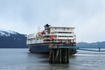
Alaska state ferries’ 2023 summer ferry schedule shows more cuts to service

The M/V Kennicott leaving Wrangell on Jan. 8, 2021. Sailings across the Gulf of Alaska from Whittier to Southeast on the Kennicott are postponed until more crew is hired. (Sage Smiley/KSTK)

The Alaska Marine Highway System announced significant changes to this year’s summer ferry schedule running May 1 through Sep. 30.

The mainliners Columbia and Kennicott will not be sailing at the same time, decreasing ferry service to Prince William Sound and Southeast communities. That’s because the state doesn’t have enough crew to run them, according to a statement from the Alaska Department of Transportation.

Sailings across the Gulf of Alaska from Whittier to Southeast on the ferry Kennicott are postponed until more crew is hired. The Columbia will be the only ferry serving Southeast’s main run between Juneau and Bellingham, Washington.

The Tazlina, which serves the northern panhandle, is also offline due to short staffing. And the mainliner Matanuska is out of service due to repairs.

For the Kachemak Bay region, the ferry Tustumena will sail the Southwest route along the Alaska Peninsula-Aleutian Chain to Dutch Harbor once a month, from May to September. There are regular scheduled port calls to Homer, Seldovia, and Kodiak Island, including the city of Kodiak, and villages of Port Lions, Ouzinkie and Old Harbor.

In Prince William Sound, the ferry Aurora will continue a regular route calling on Valdez, Whittier and Cordova. It will call on Chenega Bay and Tatitklek twice a month.

According to the state’s announcement, until officials hire additional crew to sail the Kennicott, port calls to Prince Rupert, British Columbia and Yakutat are also on hold.

You can see the full Alaska Marine Highway 2023 summer ferry schedule here.

New forecast zones should provide more accurate weather information for Alaska mariners

A fishing boat moves through stormy weather in Bristol Bay. (Brian Venua/KDLG)

The National Weather Service has announced that it’s changing its marine forecast zones to provide more accurate weather information to fishermen and boaters.

The changes are slated to go into effect on Wednesday. They follow feedback from mariners calling for more accurate forecasts closer to shorelines, says Aviva Braun, the warning coordination meteorologist for the National Weather Service’s Anchorage office.

“What we were hearing over the years as an entire Alaska Region was that our forecasts were not accurate for the nearshore environment — that small boats, subsistence, fishermen, mariners that kept close to the coastline, were not seeing the big waves and strong winds that were portrayed and forecasted,” she said.

As it stands, there’s one marine forecast for coastal zones out to 100 nautical miles.

The new marine weather forecast aims to be more specific, creating two marine forecast zones instead of one — the “nearshore forecast,” from the shoreline to 15 nautical miles, and an “offshore forecast” from 15 to 100 nautical miles.

Braun says the marine weather zones will be re-numbered, some with new boundaries, so mariners should make sure to check those changes. Some large coastal areas, like Prince William Sound, have been broken into smaller weather zones.

“The entire point of this change is to create better forecasts for people who are fishing near shore, or who are using boats to travel, for instance,” she said.

Malcolm Milne is the president of the North Pacific Fisheries Association and has been commercially fishing out of Homer since 1994.

“It’s a good upgrade,” he said. “Because a lot of times the nearshore wind is a lot different than the offshore wind.”

Milne says he’s seen winds change from 5 knots to 40 knots in less than an hour near the Flat Islands, near Nanwalek — and the more accurate weather information, the safer crews can be.

“The forecasts, the more accurate they are, the more specific they are, that just allows you to decide when you’re fishing where and when to fish and where and when to travel,” he said.

He says mariners now have cell phone service on the water and can use weather apps like Windy in addition to the marine forecasts.

For more information about the changes to the marine weather forecast and the zone maps and boundaries, go to the National Weather Service website at weather.gov/alaska/marine.

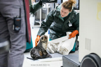
A pup rescued near Sitka is Alaska SeaLife Center’s first fur seal patient in 6 years

The Alaska SeaLife Center admitted a northern fur seal pup to the Wildlife Response Program on Jan. 31, 2023. (Courtesy Kaiti Grant/ASLC)

The Alaska SeaLife Center admitted a northern fur seal pup to its rehabilitation facility last week. It’s the Seward center’s first fur seal patient since 2017.

The female seal pup — estimated to be around six months old — was seen swimming erratically near the shore in Sitka last month, according to a press release from the center. Worried Sitka residents then reported the pup to the center’s 24-hour stranding hotline.

The female seal pup — estimated to be around six months old — was seen swimming “erratically” near the shore in Sitka last month. (Courtesy Kaiti Grant/ASLC)

Sitka is an unusual location to see northern fur seals this time of year, which the center said raised concerns for her survival by center staff. Northern fur seals typically breed much further northwest, in the Bering Sea and North Pacific Ocean.

Center staff got permission from NOAA and transported her to their facility for treatment. The center — also a public aquarium and research facility — is the only rescue and rehabilitation facility for marine mammals in the state.

Upon admission, the veterinary team discovered the pup was dehydrated and malnourished, with signs of an unknown infection in her bloodwork. She also seemed smaller than average for her age.

Staff are currently providing initial treatments and examining the pup further to understand more details about her condition.

If you see an injured or stranded marine animal, you can call the 24-hour Stranded Marine Animal Hotline at 1-888-774-SEAL.

Site notifications
Update notification options
Subscribe to notifications