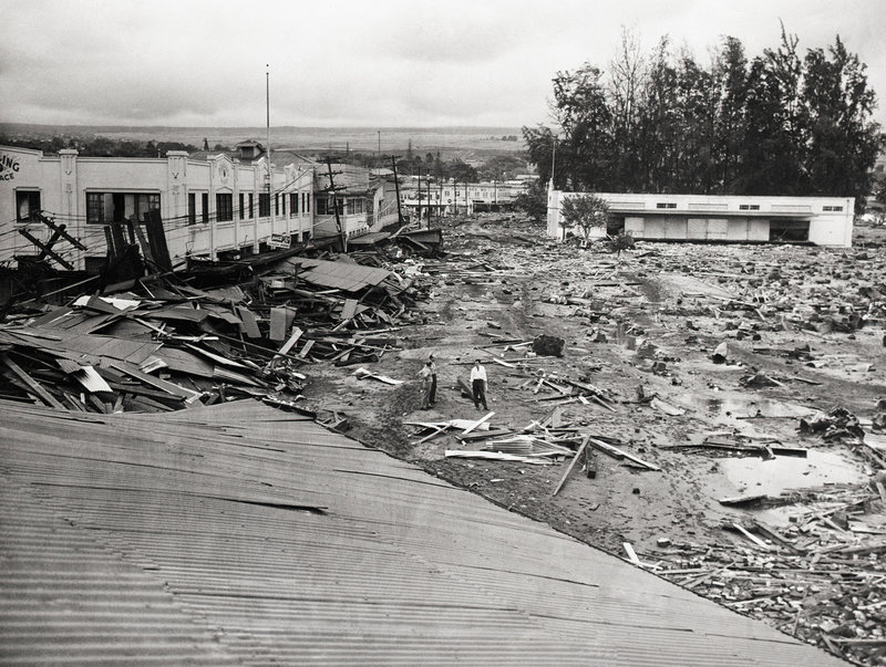
Aleutians

Aleutian Quake Zone Could Shoot Big Tsunamis To Hawaii, California

Part of the main street in Hilo, Hawaii, was flattened by a tsunami in April 1946. That big wave was triggered by a quake near the Aleutian Islands, where the edges of two tectonic plates continue to collide. Bettmann/Corbis
Part of the main street in Hilo, Hawaii, was flattened by a tsunami in April 1946. That big wave was triggered by a quake near the Aleutian Islands, where the edges of two tectonic plates continue to collide.
Bettmann/Corbis

Two teams of geologists say portions of the seafloor along the Aleutian Islands in southwestern Alaska could produce tsunamis more devastating than anything seen in the past century. They say California and Hawaii are directly in the line of fire.

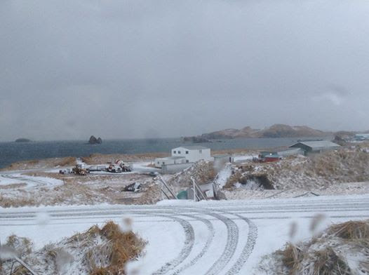
Tsunamis — the giant waves generated by undersea earthquakes or landslides — have hit U.S. shorelines before. Often they start along the Aleutian island chain that curves in an arc across the North Pacific. Right underneath, there’s a trench where two pieces of the Earth’s crust are colliding. The edge of the Pacific Plate is shoving itself under the edge of the North American Plate.

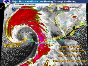
Occasionally a segment of the trench along the plate margins gives way with ferocious results — a big earthquake. These subduction quakes are the type that produces a tsunami, as a giant section of the earth collapses. It’s like waving your hand underwater — the collapse creates a wave that can travel thousands of miles. In the past century, several such tsunamis have inundated parts of Hawaii, Alaska and California.

Geophysicist John Miller and a team at the U.S. Geological Survey have been studying one particular segment that worries Miller. It’s quiet. Too quiet.

“The stress isn’t being relieved by small seismic events,” Miller says, referring to small earthquakes. “It suggests that it’s building up a tremendous amount of tension.” If too much tension builds up, the segment will unzip along the plate margin or along faults in that margin, causing a quake. His research team’s analysis was recently published online in the journal Geochemisry, Geophysics, Geosystems.

Miller says this segment of the trench, called the Semidi, poses a special risk. A tsunami created by its rupture would travel outward at a 90-degree angle from the segment. “[A] perpendicular [line] to that section of the trench,” he says, “aims right at California.” He says that means a big quake could produce a tsunami that would score a direct hit on California’s coastline from San Francisco to Los Angeles.

In the past hundred years, other tsunamis have come from other parts of the Aleutians, he points out; since the trench is shaped in an arc, each segment of it “points” in a slightly different direction in terms of the waves created when it ruptures. Consequently, tsunamis emanating from that region of the seafloor in the recent past have mostly missed population centers, or struck only glancing blows. The Semidi, in contrast, points directly at Central California.

Miller and his team have found evidence that the Semidi segment ruptures about once every 180 to 270 years. The last time it erupted was 1788.

“That last great earthquake was 227 years ago; so there’s a possibility that we’re going to have another big one at any time,” Miller says, because we’re near the end of that recurrence interval.

Miller says a tsunami from the Semidi could be as big as the one that struck Japan in 2011. “I think the public just needs to be aware that tsunamis of this magnitude can occur, and they can cause a lot of damage,” he says.

Coincidentally, another USGS team says there’s another part of the Aleutian chain that poses what the scientists say is a “previously unrecognized” tsunami threat. Geologist Rob Witter, out of Anchorage, Alaska, led that team. An underground rupture and resulting quake along certain parts of that trench, he says, would point a tsunami “straight toward Hawaii.”

Witter says this segment of the trench hasn’t been considered a threat by most scientists because it’s “creeping” — the opposing edges along the trench there are actually moving, relative to each other, but very slowly. Theoretically, that should relieve the stress, making a quake unlikely.

But not so fast, says Witter. There’s now good evidence that this creeping segment has in fact caused quakes as well as tsunamis in the past. His team has found evidence of at least six such events over the past 1,700 years that probably started with ruptures in this Fox Island section.

The evidence includes sheets of sand and debris that were pushed up onto hills on another Alaskan island as the big waves moved in. One of those tsunamis was so big it pushed huge logs and other debris about 50 feet above sea level.

Witter notes that Hawaii and California have warning systems that would alert people of a tsunami’s arrival at least four hours ahead of time. But residents have to pay attention to those warnings, if they’re to work, he says. “I think the take-home message here is, be aware and practice your evacuation plan. A tsunami along the coastlines could happen. It could happen tomorrow.”

Witter’s research was published online this month in the journal Geophysical Research Letters. He says he is not surprised that the peculiarities of these segments are just now coming to light. “Hardly anything is known about the long-term history of earthquakes and tsunamis in the Aleutian chain over the last several thousand years,” he says. There’s an urgent need, he says, to do more surveys of the seafloor in the area to understand what’s going on there, and what’s likely to happen in the future.

Copyright 2016 NPR. To see more, visit http://www.npr.org/.
Read Original Article – January 12, 2016 7:08 PM ET


The weatherman at the end of the western world

William Wells, about to launch a weather balloon on St. Paul Island, Alaska. (Photo by John Ryan/KUCB)

William Wells lives and works at what may be the nation’s most remote weather station. It’s 300 miles off the west coast of Alaska (and 500 miles off the east coast of Siberia) in the Bering Sea. Even by St. Paul Island standards, his station is remote: it’s off by itself, a few miles away from the village of 400 people who call St. Paul home.

Each afternoon, he walks from his office into a two-story-tall garage to fill up a six-foot-wide balloon with hydrogen gas.

“You wouldn’t be able to use your equipment while I would be inflating,” Wells says afterward. “We would have to do this interview outside in the wind because of the risk of static electricity that would create a potential explosion hazard.”

“But we’re not under threat right now because it’s contained safely within that latex,” he assures me.

Helium would be safer but more expensive, especially with shipping to the middle of the Bering Sea. So the St. Paul National Weather Service station generates its own hydrogen on-site.

Once the big latex balloon is inflated, Wells takes a string and ties a small gadget known as a “radiosonde” to the balloon.

“It tracks the temperature, relative humidity, and wind speed and wind direction as it goes up through the atmosphere,” Wells says.

William Wells runs back to his National Weather Service office. (Photo by John Ryan/KUCB)

Tundra sprinter

He pulls on a heavy chain to open the double-tall garage door. Then he grabs the balloon’s string in one hand and checks his watch with the other. When the clock strikes three, he sprints out the door in a mad dash: across a patch of tundra toward the gravel road in front of the station.

As the balloon above him clears the high garage door, a 30-knot wind whips it hard to the east. The wind that strafes low, treeless St. Paul Island pummels the balloon into a shape basically like a 3-D comma.

Wells needs to get far enough away from the weather station’s buildings that the wind doesn’t plow the balloon or its electronics into the side of one of them.

Once he reaches the road, he releases the balloon, and it shoots away. In this wind, the balloon takes off more like an airplane than a balloon.

Wells returns to the garage and quickly closes it up.

“Now, I’m going to apologize, but I’m going to take off almost at a full-bore sprint,” he says before doing just that.

He sprints the 100 yards back to his office to make sure the radiosonde is transmitting data in real time. It is. No need for a second launch today.

A National Weather Service radiosonde awaiting launch on St. Paul Island, Alaska. (Photo by John Ryan/KUCB)

Hundreds of Balloons

It’s a daily routine for Wells. For the balloon, it’s a one-time affair. As it rises 20 miles into the sky, it swells to about 40 feet in diameter. Then it bursts and returns to Earth as debris, most likely somewhere in the Bering Sea. But not before it has sent back valuable data.

“We are such a remote location,” Wells says, “Our data is pretty precious.”

That data gets used within the hour in the 4 p.m. NOAA weather forecasts that mariners and others rely on in the Bering Sea and beyond

Twice a day, like clockwork, balloons are released from hundreds of locations around the world at noon and midnight Universal Time (3 p.m. and 3 a.m. Alaska Daylight Time). Before they burst in the upper atmosphere, they help weather forecasters pinpoint what’s going on overhead.

In a report on the impacts of released balloons, marine biologist Jan van Franeker with Wageningen University in the Netherlands says, even if made of natural latex, they are a danger to wildlife, especially seabirds. He says remains of weather balloons can be found regularly on European beaches.

“The risk of wildlife suffering or dying from balloons may be best balanced against usefulness or necessity of balloons released,” van Franeker writes. “Latex weather balloons are an essential element for reliable weather forecasts to the extent that human life may be affected. But the short joy of a mass of party balloons disappearing into the sky?”

Each National Weather Service radiosonde includes a self-addressed envelope encouraging anyone who finds it to mail the gadget back for reuse.

A Century in St. Paul

The St. Paul weather station has been collecting data since 1915. It’s been successfully sending balloons into the sky, in winds up to 50 miles per hour, since 1948.

Wells says he’s always loved the weather, especially the meat and potatoes of gathering the raw information needed to make a forecast.

“It takes a lot of skill and hardiness to do it, and I’m proud to do it,” he says.

The National Weather Service is testing an automatic balloon-launching device at its station in Kodiak in November. Someday, human launchers like Wells could be replaced by machines at the 13 weather stations in Alaska and those across the country.

William Wells releases a weather balloon on Alaska's St. Paul Island. (Photo by John Ryan/KUCB)
William Wells releases a weather balloon on Alaska’s St. Paul Island. (Photo by John Ryan/KUCB)

Far From Home

For now, Wells is a continent–and 300 miles of Bering Sea–away from his native North Carolina, but he doesn’t mind.

“I feel privileged to be doing this,” he says. “I’d always wanted to work for the weather service and now I am working for the weather service, and I couldn’t be happier.”

Some St. Paul residents dislike it when their home is described as “the middle of nowhere.” And in some ways, the Pribilof Islands are centrally located: St. Paul is home to the world’s largest Aleut community; Trident Seafoods claims to run the world’s largest crab-processing plant there. Nearly half of all seafood harvested in the United States is hauled up from the Bering Sea.

Still, travel to St. Paul from almost anywhere else (it’s a three-hour, thrice-weekly flight from Anchorage on planes so small they ask you what you weigh before assigning you a seat), and you realize that St. Paul is on the distant outer perimeter of the Last Frontier.

Wells says his quiet life on the outskirts of St. Paul, on the outskirts of America, is lacking in some creature comforts, but it’s been good for him.

“I lost 25 pounds after moving up here because I didn’t have the temptations of fast-food restaurants about me,” he says.

It’s a different career path than his classmates who get dressed up and made up and sweep their arms in front of maps on TV news. Jobs like his make their forecasts possible.

“They can have the TV and the radio,” Wells says. “I’ll stick with this.”

Adak sifts through aftermath of disastrous storm

Crystal Dushkin on Atka says in a Facebook post that the community’s playground was toppled by the storm. (Photo courtesy of Crystal Dushkin)

A major storm ripped through the Aleutian Chain over the weekend, leaving a path of destruction in its wake.

It was less severe than expected in some areas — like Unalaska and St. Paul Island — and more severe in others.

On Adak Island, hurricane-force winds topped out at 122 miles per hour on Sunday.

Adak city manager Layton Lockett said the damage was substantial.

“Lot of personal property damage … a lot of the bigger warehouse buildings had significant damage from the pressure and the battering that we received,” Lockett said.

Tugs broke from their moorings, roofs were torn off, and windows were broken in. Several air-cargo containers were also blown across town. But Adak’s water, sewer and telecom systems escaped relatively unscathed.

This data snapshot was taken at around 4 a.m. on Sunday morning, Dec. 13. The term “low” is used for a hurricane-force storm in this case. (Image from NWS-Anchorage)

Lockett said even as winds topped 100 miles per hour, the weather forecasts were still reading 90.

“We are very disappointed in the National Weather Service in their communications aspect,” she said. “Their forecast was not nearly close to being anywhere accurate — nor was it timely updated.”

National Weather Service meteorologist Michael Kutz said NWS’ direct radio contact extends out as far as Dutch Harbor. Beyond that, warnings happen through commercial radio’s Emergency Alert System, the internet and direct correspondence.

“When we put out these warnings they go through several different chains of communication,” Kutz said. “Depending on who is available at each location will dictate how it’s received. Most locations receive (forecasts) through some sort of law enforcement.”

The worst of the storm has passed in Adak, and the community is currently navigating the process of a disaster declaration.

The storm has turned north and is bearing down on St Lawrence Island, the Seward Peninsula, and the Yukon Delta.

Fewer fish, fewer kids: Remote Alaskan island struggles to keep its students

St. Paul students line up to stick their hands inside "blubber mitts" (Crisco-lined plastic bags) to learn how marine mammals stay warm in the cold Bering Sea. (Photo by John Ryan/KUCB)
St. Paul students line up to stick their hands inside “blubber mitts” (Crisco-lined plastic bags) to learn how marine mammals stay warm in the cold Bering Sea. (Photo by John Ryan/KUCB)

As the superintendent of one of Alaska’s smallest and most remote school districts, Connie Newman wears many hats. The Pribilof School District has ten students at its school on St. George and 73 on St. Paul, a pair of lightly inhabited islands 300 miles off Alaska’s west coast in the Bering Sea.

After declining enrollment forced cutbacks two years ago, Newman took on the mantle of St. Paul School principal as well as district superintendent.

Now, in the predawn gloom before the start of the school day, she greets each St. Paul student as they hop down from an SUV or four-wheeler. On St. Paul, the school day starts with a bilingual Pledge of Allegiance: first in English, then in Aleut.

We spoke while she was sweeping the gym floor.

St. Paul’s gym doesn’t see as much action as it used to. This is the first year the St. Paul Sea Parrots haven’t been able to field a basketball team.

“Basketball’s a big deal,” Newman said. “We had a very good team, in fact, last year. But even then, it’s a coed team, boys and girls. This year, no, we do not have enough.”

Some families have left the island; others have sent their kids to boarding schools in other parts of the state.

“The course offerings are pretty limited here,” Newman said. “We can’t offer a lot of the art and music.”

St. Paul students on a field trip with visiting scientists. (Photo by John Ryan/KUCB)

While on a school field trip to look for sea lions, eighth grader Carley Bourdukofsky said she doesn’t really like going to school at St. Paul.

“You don’t really learn that much. I’d like to go to Mt. Edgecumbe next year.”

Mt. Edgecumbe High School is a boarding school in Sitka.

Ninth grader Sonia Merculief transferred to a boarding school in Galena, in the Alaska interior, this fall.

“It was a better education,” she said. “It’s kind of more strict and stuff. It’s more learning, more opportunities.”

Merculief said she got homesick at the isolated school on the Yukon River, so she came back to St. Paul. But she wants to try again.

“I’m going to ask my mom this time if I can reapply for next semester,” she said.

St. Paul does have course offerings that students can’t get elsewhere, like classes in Unangam Tunuu, the Aleut language. In October, the school hosts a week of Bering Sea-focused science classes called Bering Sea Days.

Every year, university scientists and local tribal officials converge on the St. Paul School to teach about the island’s biology and traditions. Guest instructors come from as far away as Texas and Oregon. The week is largely paid for by the Central Bering Sea Fishermen’s Association, the island’s fishing industry group. On field trips and in the classroom, students learn about the seabirds and seals that gather by the hundreds of thousands in the Pribilof Islands and the environmental changes that threaten the islands’ natural abundance.

One group of students accompanied two local sea lion hunters as they scanned the surf at sunrise, looking for meat for the winter.

Carley Bourdukofsky said she likes that part of the school year.

“I like to learn new things and different things about our island,” the eighth grader said trip while out looking for sea lions.

Fewer fish, fewer kids

By lots of measures, the St. Paul School is struggling.

Just 18 percent of St. Paul students met all state standards in English or math, according to the new Alaska Measures of Progress tests. Statewide, 35 percent of students met state standards in English and 31 percent met them in mathematics.

A study done for the Alaska legislature this year found that the Pribilof district would have to boost salaries by 57 percent to attract and keep highly qualified teachers. That’s because of the high cost of living in the middle of the Bering Sea. A box of cereal can set you back nearly $9 at the Alaska Commercial store on St. Paul. A bag of pretzels? Nearly $10.

Four out of five students on the island are poor enough to qualify for free or reduced-price lunches, nearly twice the statewide rate. But like many small schools in Alaska, St. Paul doesn’t serve lunch. It did offer snacks last year.

“That was the Alaska Grown grant, which was discontinued due to the budget,” Connie Newman said.

She said she has a great staff and supportive families on the island, but declining enrollment means less state funding.

“We still have the same costs, even though we have fewer kids,” she said. “I mean, you’re talking heat and lights. No respite.”

Pribilof School District superintendent Connie Newman's many duties sometimes include sweeping the St. Paul School gym. (Photo by John Ryan/KUCB)
Pribilof School District superintendent Connie Newman’s many duties sometimes include sweeping the St. Paul School gym. (Photo by John Ryan/KUCB)

Newman said a driving force behind the school’s declining enrollment is something the school can’t do much about: people leaving the island in search of a healthier economy.

“Our fishery has really been suffering, and we are allowed to take less and less halibut,” she said.

The remote, tundra-covered island’s economy revolves around halibut fishing, but the fish have been getting fewer and smaller. Warmer ocean conditions are apparently partly to blame; so is the fishing industry. In the Bering Sea, more halibut are caught accidentally and thrown away by Seattle-based boats trawling for other types of fish than the local halibut boats catch on purpose.

“We had one of our big families, they just took their boat and left last year,” Newman said. “I’m sure there’ll be more if it continues.”

The school got a bit of a reprieve in December from Seattle, of all places.

Scientists with the International Pacific Halibut Commission announced that there’s enough halibut in the eastern Bering Sea to allow a “substantially larger” fishery next year. IPHC scientist Ian Stewart said the accidental catch, or bycatch, of halibut dropped this year.

“All in all, quite good news here in terms of bycatch,” Stewart said. “We saw some very large reductions.”

Politically appointed officials with the North Pacific Fisheries Management Council decide the actual catch limits. But the scientists’ announcement makes it less likely that families will be forced to leave St. Paul this school year.

Reporting from St. Paul Island made possible in part by a grant from the Institute for Journalism and Natural Resources.

St. Paul, Alaska (Photo by John Ryan/KUCB)

Some halibut may successfully adapt to warmer seas, others may not

Juvenile Greenland halibut. ( Photo by Dongwha Sohn/CEOAS)
Juvenile Greenland halibut. ( Photo by Dongwha Sohn/CEOAS Oregon State)

While their average size is decreasing and 500-pounders are rare today, new research suggests Pacific halibut may adapt favorably to increased ocean temperatures.

Greenland halibut may not be so lucky.

Dr. Cathleen Vestfals, Oregon State University, presented her Ph.D. research at the UAF School of Fisheries and Ocean Sciences Juneau Fisheries Seminar recently.

Vestfals researched the life cycles of two different halibut species that reside in the Eastern Bering Sea: Pacific halibut and Greenland halibut. Both are large flatfish, have big mouths lined with sharp teeth and inhabit some of the same areas.

Pacific halibut get much larger than Greenland halibut do: 8 feet long compared to 4 feet. Pacific halibut are mottled green on top and white on their bottom-facing side. Greenland halibut are blackish purple on top, iridescent yellow-green on their underside.

And they may respond differently to climate change.

Juvenile Pacific halibut (Photo by Morgan Busby/NOAA)

For her research, Vestfals compared the success of the two flatfish species in past warm and cold years.

Pacific halibut live from California, north through the Bering Sea and across the Pacific to Japan. Due to the extent of their southern range, Pacific halibut may continue to breed and disperse successfully if the ocean becomes a few degrees warmer.

“We would expect that they would do really well under warming conditions. Their habitat is likely going to expand under warming scenarios,” Vestfals said.

Greenland halibut, on the other hand, occupy only circumpolar waters. If the ocean warms by a few degrees, their cold water habitat may contract northward.  According to Vestfals, fisheries scientists already “have noticed a northward shift in species and changes in species assemblages in response to warming.”

So global warming could mean fewer Greenland halibut.

According to Vestfals, Pacific halibut “have a better chance than Greenland halibut would to make it.”

To follow flatfish, visit the Flatfish Fan Club Facebook page Vestfals made.

Unalaska museum closes during search for new staff

The Museum of the Aleutians remains temporarily closed. (Photo by Greta Mart/KUCB)

Unalaska’s Museum of the Aleutians will be closed for the foreseeable future.

The museum’s board of directors has decided to keep the museum closed while the board conducts a search for a new executive director, collections manager and education programs director.

Board member and city manager David Martinson said this morning that given there is currently now only one employee, the museum would be closed for the time being.

He added the board was working to reopen the museum as soon as possible.

Martinson also says that the board received outgoing executive director Zoya Johnson’s letter of apology to the community but has not released it to the public.

Johnson resigned as museum director last week. Her last day on the job was Monday.

Site notifications
Update notification options
Subscribe to notifications