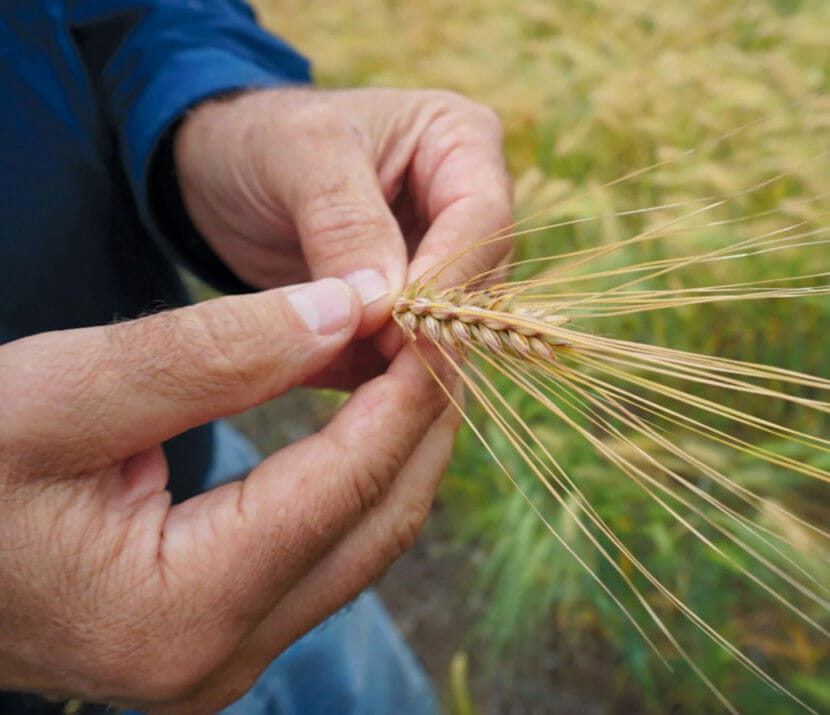
Delta-area farmer Bryce Wrigley shows the tightly clustered seeds atop a ripe barley stalk. (Erin McKinstry/Edible Alaska)
The state is offering financial help to Alaska farmers who are struggling to pay high prices for livestock feed that’s in short supply after last year’s poor harvest. But some farmers say setting up a grain reserve would be a better way to help them recover in lean years.
The state has launched two new programs to help farmers pay for livestock feed. Prices are about double last year’s because spring planting was delayed by last winter’s heavy snowfall and fall-harvest crop yields were low due to early frosts and other unseasonable weather.
“It was tough,” says local UAF Cooperative Extension Service agent Phil Kaspari. “We had those high input costs, poor returns, and a number of people are in survival mode.”
Kaspari said in an interview Monday that higher prices for feed, fuel and fertilizer have driven some producers to cut back on their livestock.
“The last thing that we wanted to see happen is people having to cull down their herds,” he said, “but in fact that’s what a number of these people have had to do.”
Alaska Farm Bureau President Scott Mugrage says the problem affects many farmers around the state.
“It’s not just people are paying a high cost for feed,” he said. “We’re going to run out of grain in the state of Alaska.”
Mugrage grows hay and other feed for the 600 head of cattle at his farm near Delta Junction. And he says producers appreciate the help the state is offering through its Food Security Cost Assistance Program. A state Agriculture Division spokesperson says about 70 farmers have applied for payouts from the program, with requests ranging from about a thousand dollars to nearly $150,000.
But, Mugrage said, “I’m just not sure that this type of assistance is what was needed to carry us through.”
He says another new program announced by the state last week, however — the Alaska Barley Transportation Support Grant Program — is more likely to help, even though the window to apply for a grant closed on Monday.
“I thought they’d be better off with offsetting some transportation costs with imported feeds, because that’s what we don’t have,” he said. “We don’t have grains.”
Mugrage says he was disappointed that the state didn’t follow through on what he and others believe is the best solution to protect livestock producers during lean years: reviving plans to establish a grain reserve.
“This is exactly the type of year that proves we need this reserve to be established,” he said. “It’s like a savings account. That grain’s always going to be there, it can be released during a time of drought or disaster, and then could be right back re-apportioned after the drought. ”
Mike Schultz, another Delta area farmer, agrees.
“It is a good idea, for several reasons,” he said in an interview Monday. “One is over the course of several years, that grain reserve would get built up and be the cushion that we need in the event of another poor production year.”
Mike Schultz raises barley and other crops on the 6,000 acres he farms with his brother, Scott. He’s also serves as board chair of the Delta-based Alaska Farmers Co-op, which built grain elevators and a fertilizer plant with state funding back in the 1980s. The organization ran into financial problems and declared bankruptcy in 1993, and deeded those assets to the state. Then in 2015, the state leased it back to the co-op for 25 years at a cost of a dollar a year. Schultz says it would be the perfect place to set up a grain reserve.
“It would really benefit the livestock producers throughout the state,” he said, “because they would then know there’s an adequate supply of feed for their animals.”
Both Mugrage and Kaspari agree. And they’d had hoped the state would move ahead on setting up a grain reserve after Gov. Mike Dunleavy talked about it in June at Nenana’s annual Agriculture Day event. An Agriculture Division spokesperson said last week that state officials are still considering a grain reserve, but decided to move ahead on the other programs in an effort to get help to farmers this year.
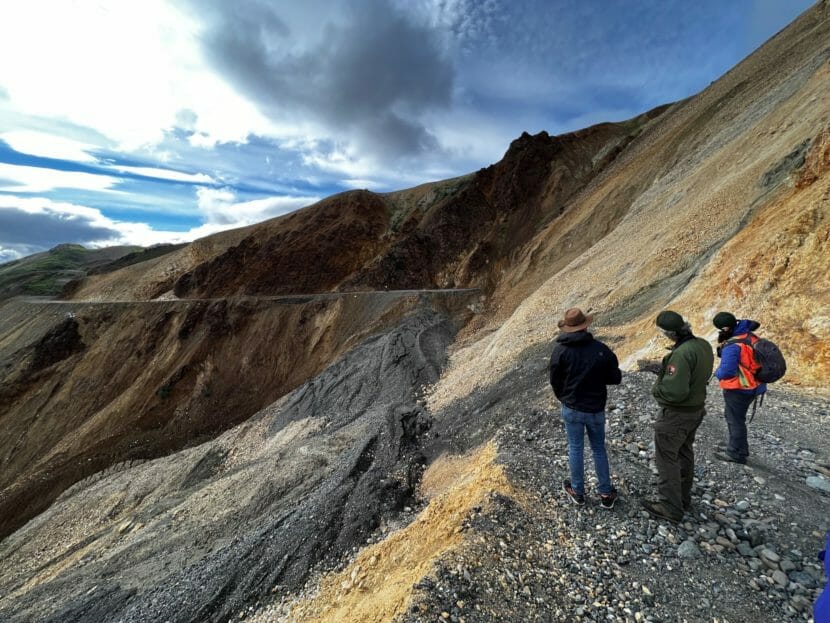
Dave Schirokauer, Denali National Park and Preserve’s science and resources team manager, and two visitors survey the landslide damage on July 21, 2022, at the park’s Pretty Rocks site. The area, a high point overlooking a scenic park valley, is about midway along the park’s 92-mile road. The exposed, multicolored slope had been creeping slowly over time, but acclerated warming caused big movements and, ultimately, made the road impassable at Pretty Rocks. The National Park Service has now selected a contractor to build a bridge intended to allow tour buses to pass over the unstable site. (Photo provided by National Park Service)
A remedy is on the way to overcome a barrier to visitor movement through one of Alaska’s premier tourist attractions. But it still will take some time to happen.
The National Park Service has selected a contractor to build a bridge over the halfway point of the sole road through Denali National Park and Preserve, a site where intensifying thaw has triggered an ongoing landslide that has made the area impassable. If all goes according to schedule, park visitors will be able to travel the full road by the summer of 2025, said Brooke Merrell, the park’s superintendent.
The site, an exposed, high-altitude, steep area called Pretty Rocks, has been closed to traffic since late August of 2021, when park managers could no longer maintain it safely. It has since slumped so far that a section of road has been obliterated.
The scheduled construction, expected to start in May, will mean the passage of three full tourist seasons without access to the second half of the Denali park road — a headache for the tourism industry, but a necessary step to ensure future access, Merrell said.
“You just can’t look at it and not immediately understand why that project is necessary,” she said.
Another reality is that climate change is reshaping the landscape and creating new hazards.
“In Alaska, the changes in geology that are happening are a ‘now’ thing. They’re not a ‘10- or 20-years-from-now’ thing,” she said.
The contract with Granite Construction, a California-based firm with an Alaska regional office and several Alaska operations, was formalized last week, Merrell said. The cost of the project is capped at $102 million, she said.
Money to complete the project has been made available by the recently passed omnibus budget bill. That $1.7 trillion package includes $1.5 billion for the National Park Service to address impacts of natural disasters, which will include the ongoing landslides in Denali, as well as wildfire and flood impacts in other parks.
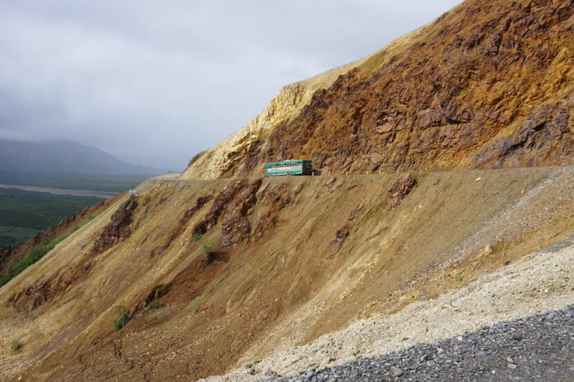
A shuttle bus passes through the Pretty Rocks area at Denali National Park on July 21, 2020. By late August the following year, the area became too dangerous for the public to travel by vehicle, and the Park Service shut down the road at Pretty Rocks, a site at about the halfway point of the 92-mile park road. (Photo by Yereth Rosen/Alaska Beacon)
While there is not a specific amount of money designated for Denali and its road fixes, there will be enough to get the work done, said Sen. Lisa Murkowski, the Alaska Republican who helped write and shepherd the package.
“What we have done in this measure is we have ensured that the funding to support the road will be covered in full, so that we do not miss yet another season,” Murkowski said in a Dec. 23 news conference. “It’s a bigger project than anybody had ever anticipated, and so it did require additional funding.’
Previously, $25 million had been set aside for the project through the Infrastructure Investment and Jobs Act.
The ongoing Pretty Rocks landslide, tumbling down a high slope that overlooks some braided tributaries of Denali’s Toklat River, is part of a trend in mountainous areas all around the far north. Warmer air temperatures and more rainfall has thawed permafrost soil and loosened the ice-laden, high-altitude geologic formations known as “rock permafrost.” Additionally, in some areas, slopes are being destabilized by the melt of glaciers that buttress mountains.
Effects can be dramatic and disastrous. In Greenland, a localized tsunami produced by a thaw- and melt-induced landslide in 2017 killed four people in the fishing village of Nuugaatsiaq. In 2015, a mountainside collapsed in a remote coastal area of Wrangell-St. Elias National Park and Preserve, dumping enough rock and sediment into a fjord to cause the fourth-highest tsunami ever recorded. Glacier Bay National Park and Preserve and neighboring mountainous areas of Canada are also considered global hotspots for these thaw- and melt-related landslides.
Among the areas where frozen terrain is prone to slides, Pretty Rocks stands out.
The warming of air temperatures in Denali has accelerated. From 1950 to 2010, the increase was tracked at a rate of 4.3 degrees Celsius (7.7 degrees Fahrenheit) per century – the highest rate for that period measured at all U.S. national parks, according to the Park Service. Warming has intensified since then; temperatures in Denali rose by nearly 2 degrees Celsius (3.6 degrees Fahrenheit) from 2014 to 2019, according to Park Service experts. May-to-September rainfall since 1950 has also increased, though with a lot of variation, as is the case for the state as a whole.
Geologically, the Pretty Rocks area is precarious because of its composition. It holds a conglomeration of rock glacier, permafrost, clay and other substances layered atop each other.
The location – the midpoint of the only road through one of the crown jewels of the U.S. National Park System – gives Pretty Rocks a high profile.
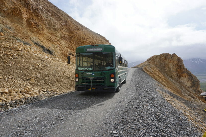
A shuttle bus travels through Denali National Park’s Pretty Rocks area on July 21, 2020. The road had already become dangerously narrow by then. (Photo by Yereth Rosen/Alaska Beacon)
The slope at Pretty Rocks has actually been moving for a long time. Until the past decade, though, the movement was slow, at times even barely perceptible.
Before 2014, the Pretty Rocks’ slope movement was measured at inches per year, according to the Park Service. It sped in subsequent years to inches per month, then inches per week and then inches per day. By 2021, the rate was more than half an inch an hour, until August of that year, when a section slumped abruptly and the Park Service imposed an early end to some visitors’ Denali trips.
The past season was the first with the full-year closure at Pretty Rocks. Park visitors, generally ferried by shuttle buses, could travel no farther than the road’s first 43 of 92 total miles.
Denali had more than 400,000 visitors in 2022, Merrill said, substantially less than the record 642,809 counted in 2017, but still a busy season. The road closure itself proved to be a subject of interest, she said. Many visitors who rode the bus to the temporary end of the line walked farther to take in a full view of the collapsing Pretty Rocks slope, seeing first-hand the impact of thaw on Alaska’s mountain terrain, Merrell said.
“It was a very popular hike. It was pretty great, actually,” she said.
This coming season, those unobstructed views won’t be available. Bridge construction will be underway, though the Park Service is striving to limit disturbances like noise and truck traffic, Merrell said.
Even when the bridge over Pretty Rocks’ sliding slope is completed, Denali’s landslide problems will continue.
There are more than 140 other identified sites in Denali where the road is affected or threatened by landslides, Merrell said. That will mean more work in the future to protect the road and visitors, she said.
“We are anticipating that we’ll have more big projects — not a Pretty Rocks, but big, still,” she said.
One project already in the queue is mitigation work at an unstable site called Bear Cave, which is near Pretty Rocks.
A small landslide on a slope near the Denali National Park road is seen on July 21, 2020. The park road corridor is dotted with more than 140 known landslide areas, and slide risks are increasing in the permafrost terrain as temperatures become warmer. (Photo by Yereth Rosen/Alaska Beacon)
Other Alaska national parks also have landslide problems threatening road corridors.
One is in Wrangell-St. Elias, where visitors use the 60-mile McCarthy Road to reach the Kennecott Mines National Historic Landmark, the town of McCarthy and other attractions. By mid-century, air temperatures along the McCarthy Road corridor are expected to average above freezing, making slides more likely, according to a study by University of Alaska Fairbanks scientists.
Even far-north Gates of the Arctic National Park and Preserve, located above the Arctic Circle, is projected to have landslide-prone conditions in the future, according to the study, published in the journal Atmosphere. Average air temperatures are on track to be above freezing along the corridor that is proposed to hold a section of a yet-to-be-built industrial road, the study said. Of the 211 miles of road proposed in the Ambler Mining District Industrial Access Project, about 20 miles would cross through the southern part of Gates of the Arctic.
Correction: The original version of the article incorrectly described the bridge. It will be a steel truss bridge, not a suspension bridge.
Haley and Patrick Holland. (Courtesy of Haley Holland)
Fifty-six-year-old Patrick Holland has been dealing with congestive heart failure for much of his life, but he says he’s too young to die.
“I had my first heart attack at 29 years,” he said. “My dad died from it at an early age. His brother, my uncle, died at 48. It’s been taking the lives of my family for a long time.”
Three years ago, doctors told Holland he needed a transplant. His heart is twice the size it should be. But he’s at home this week after missing his heart transplant because no planes could land after Seattle’s worst ice storm in a decade.
It took months to become eligible for a transplant, a time spent repeatedly flying to Seattle for dozens of tests at University of Washington Medical Center.
“They checked my lungs, my kidneys, my gallbladder, my digestive tract, man. They put gauges in my neck to check the pressure to my heart,” he said. “My mind was like, man, I hope I get through all this testing before I die.”
Because of his disease, Holland gave up the job he loved as a personal assistant to seniors with disabilities. His wife has been writing about their experience since 2019, saying it helps her cope.
Holland’s family had considered a temporary move to Washington, but Patrick is healthy enough to travel the four-hour direct flight to Seattle.
A transplant coordinator called Holland on Dec. 22 to say they had a heart that was a perfect match. But he would need to get to the University of Washington Heart Institute within a day. He and his brother booked an evening flight to Seattle and arrived at the airport in the midst of a holiday travel crush, complicated by stormy weather.
“I immediately just jumped to the front line, and I apologized to everybody. I said, ‘Ma’am, I’m looking to get a heart transplant and my plane boards in 30 minutes.’ And she said, ‘Oh my gosh, get over here.’ And she immediately pulled me to the side, started looking, and she said, ‘Oh no, your flight has been canceled.’ And I was just — everything left my body.”
Freezing rain briefly closed all three runways at Seattle-Tacoma International Airport, but Holland says Alaska Airlines agents managed to get them on an early morning flight to Seattle.
“I was comfortable and excited and happy. Most of the fear had gone away,” he said.
It looked like he would get his new heart.
“I felt the landing gear go down,” he said. “I heard the pilot say, ‘welcome to Anchorage.’ I looked at my brother and I laughed and I said, ‘He must be really tired.’ Because at this point it was like 3:30, 4 o’clock in the morning, and I just figured now we’ve been in the air four hours. It does not take four hours to get to Anchorage.”
The ice storm in Seattle had forced the plane back to Anchorage, and Holland missed the window to get the heart transplant.
“ I just lost,” he said. “I felt life just leaving my body. I was so, I so spent on so much emotion, up and down roller coaster.”
Two weeks later, he’s packing to leave his wife and four children in North Pole and move to Seattle to wait for another suitable heart.
“I don’t wanna ever miss another chance,” he said. “It’s just not gonna happen.”
He tells everyone who wishes him well to always be thankful for what they have, and to register as an organ donor.
A wood bison calf in Alaska, June 17, 2007. (Creative Commons photo by pbarbosa)
It’s been another good year for Alaska’s wood bison herd. A recent population survey shows that the Lower Innoko and Yukon Rivers herd is healthy and growing.
The herd was started in 2015 with the transplant of 130 animals from Alberta, Canada. The bison suffered significant losses in 2018 and 2020 due to heavy snows, winter rains and late springs, but better weather over the last two years has seen a rebound with record and near-record calf production.
Department of Fish and Game wood bison biologist Tom Seaton says a Nov. 28 population survey reflects significant herd growth.
“The minimum count of bison out there was about 150, so the population grew about 45% in this last year, and about 19% of that was just from natural growth from having a good calf crop and really good survival of yearlings and adults,” he said.
Seaton says the other 26% of growth is from the introduction of 28 yearlings, again imported from Canada and barged out to the Lower Innoko River area this past summer. He says the young animals have the potential to accelerate herd growth.
“Once they get to the reproductive age classes, which is like 3 years old to twenty years old, they’ll be producing a lot of calves,” he said
The wood bison reintroduction project has been shepherded by Alaska Native groups, Fish and Game, the Bureau of Land Management and others. The goal is to reestablish the animals in Alaska, where they disappeared from the wild over a hundred years ago.
Seaton says if the Lower Innoko Yukon herd continues to grow, limited harvest could be allowed according to a directive from 30 different interest groups, which together manage the herd.
“When that three-year average growth shows enough that you can also harvest ten animals and have a similar amount of growth, then we’ll start to hunt,” he said. “And if there are good winters in the next five years, then it will probably happen in the next 5 years.”
Meanwhile, a second wood bison reintroduction project is being considered. Seaton says 10 bison at the University of Alaska Fairbanks Large Animal Research Station, another 30 at the Alaska Wildlife Conservation Center, plus additional animals from Canada could seed a herd in the Eastern Interior.
“Some folks in the Upper Tanana have written the governor asking for wood bison there,” he said. “There’s also quite a bit of interest in the Lower Tanana. There’s some interest in the Yukon Flats.”
Seaton says planning meetings this winter will bring together interest groups to talk about a new reintroduction project.
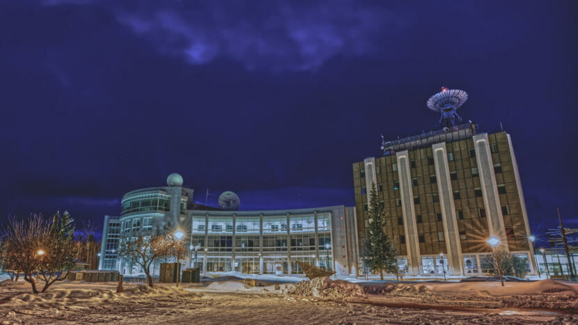
The Elvey Building (right) on the University of Alaska Fairbanks campus is home to the Geophysical Institute and Alaska Satellite Facility. The Akasofu Building (left), houses the International Arctic Research Center. (McKade Sorensen/Alaska Satellite Facility)
A German American scientist has flown from Fairbanks to present at a conference in Chicago about satellite research of the Himalayas, as well as Central and South America.
If that all sounds rather global, well, that’s exactly the kind of collaborative and far-reaching work happening at NASA’s Alaska Satellite Facility, based at the University of Alaska Fairbanks’s Geophysical Institute.
Franz Meyer is a professor of remote sensing at UAF and the Satellite Facility’s chief scientist. Like many other researchers, he’s at the American Geophysical Union’s annual conference this week.
As Meyer explains, the work he’ll present is about the benefits of using satellites to map what’s happening on the ground in flood-prone areas, even if they’re covered by trees or clouds.
Listen:
The following transcript has been lightly edited for clarity.
Franz Meyer: It has these capabilities to penetrate through clouds and observe during day and night. So the communities in, say, Central, South America and Hindu Kush Himalaya, they are very interested in using these datasets and using them mostly for disaster management, food security and ecosystem stability monitoring. So, you know, there’s a local interest, of course, for local food security. These events affect the availability of food resources in the area, and also livelihoods. You know, how many people and what population is affected, etc. But on a global scale, one of our other partners in these projects, for instance, is the U.S. Department of Agriculture, and specifically the Foreign Agricultural Service. They need to know impacts of weather events on agriculture to understand things like food availability, market prices for different crops, etc., for these bigger events, like the monsoon rains in the Hindu Kush Himalaya. It has global implications on prices and availability of certain resources.
Casey Grove: Tell me about why that particular type of satellite is valuable for the work that you’re doing.
Franz Meyer: So radar remote sensing is useful because at microwave wavelength, signals can penetrate through the atmosphere, even during cloudy conditions. The 24/7 capabilities is great for Earth observation. So we put these radar systems on satellites and let them image and look at the surface. And we can use repeated observations to look for changes of the earth environment, both changes of the structure such as deforestation, agriculture growth, urban sprawl, etc. But we can also look very closely at surface displacement. If you think of, you know, volcanic eruption, or active volcanoes, or earthquakes or permafrost domes, the ground in these areas is going up and down and moving with the geophysical activity. And radar is just really good at measuring distances. And so by looking at and tracking distances over time, we can measure millimeter to centimeter scale surface displacements that relate to a lot of natural hazards and to a lot of the geophysical phenomena that we have here in Alaska.
Casey Grove: Gotcha, yeah. So now I’m going to ask you, why is someone based in Fairbanks doing this kind of work? And, I mean, maybe that gets to the technology and how the satellites work, and why the Alaska Satellite Facility is where it is. But why you? Why Fairbanks?
Franz Meyer: Part of this is because of the Alaska Satellite Facility. ASF was created originally as what’s called a ground station. So we operate a number of NASA-owned communication antennas to communicate with Earth observation satellites. And because these satellites are passing usually over the pole, the further north you are in latitudes, the more often you can see these satellites. So putting a ground station at high latitudes makes sense, because you have more contact, and you can download more data and an uplink more commands to the satellites than in lower latitudes. And so Fairbanks was picked at the time in the 1990s because it was the northernmost U.S. city that had stable power.
Casey Grove: Franz, I wanted to ask you just about the the blue dish on top of the Geophysical Institute. I know that the Satellite Facility uses other dishes, and that’s not the only one. But that’s kind of an iconic thing at this point, right? When you look up at West Ridge at the University of Alaska Fairbanks and you see that, it’s just part of that skyline, right?
Franz Meyer: Yeah, Casey, that’s a very good point. So, you know, a lot of people in Fairbanks and maybe in Alaska recognize the blue dish on the university campus on top of the GI building. It was put on the roof in the 1990s. We, overall, we operate currently four dishes, but this is the one that’s known to most people. It was actually replaced a few years ago, upgraded to have more broadband capabilities and be able to download more datasets. And one of the funny things we got from from the community here in Fairbanks is to make sure that the dish is blue again. It, sort of, was so iconic, that people didn’t want that to change. So that was one of the main input we got from Fairbanks itself was to make sure that the new dish that we put up there is blue. And of course it is again.
Casey Grove: Why was it blue to begin with?
Franz Meyer: So I was not around at the time, but my understanding is that it was to have it blend in more with with the sky and be a little bit less visible. You know, people didn’t initially like the idea of having this dish on the building. And so that helped, a little bit, alleviate people’s concern. But I think now it’s just an established part of the skyline here in in Fairbanks.
Casey Grove: Yeah. Well, so, we’ve talked a little bit about the past for the Alaska Satellite Facility, and then what you’ve been working on here, you know, currently that you’re gonna go present at the AGU conference. What’s the future for ASF? What, you know, I guess in the near term, what are you looking forward to?
Franz Meyer: Yeah, so, ASF, actually already over the last few years, we have been preparing ourselves for a very large upcoming mission that is being launched by NASA. There is a mission that’s called NISAR. So that mission is a collaboration between NASA and India. And it’s going to be launched in 2024. And it’s going to provide unprecedented data for monitoring dynamic signals on the planet. It’s going to provide unprecedented data volumes. The mission will provide about 50 petabytes of data per year. And so over three years, to give you sort of a scaler, this mission alone will provide more data than NASA currently holds in all of our archives combined. And we at ASF are the ones that will hold all these datasets. We’re also a downlink station for NISAR, so we’ll bring some data directly down through the dishes in Fairbanks into our archives.
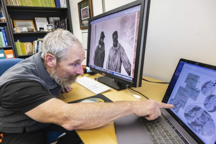
Professor of geophysics Matthew Sturm points to the Sourdough expedition’s path in summiting Denali 1910 from studying newly found photographs located at the Elmber E. Rasmuson Library archives. (JR Ancheta/UAF-GI)
There’s new proof of the success of a pioneering ascent of Denali. Historic photographs from the 1910 Sourdough expedition were found this fall at the University of Alaska Fairbanks.
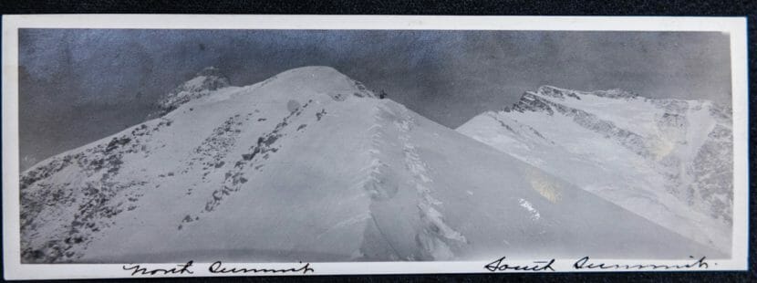
The black and white images provide hard copy evidence that Alaskans Pete Anderson, Billy Taylor, Charlie McGonagall and Tom Lloyd — known as the Sourdough expedition — got members to the top of Denali’s 19,400-foot North Peak in April 1910 — a feat that’s long been subject to skepticism.
“They went,” said UAF geophysics professer Matthew Sturm, who found the photos. “They did the climb, but they were not good about documenting it.”
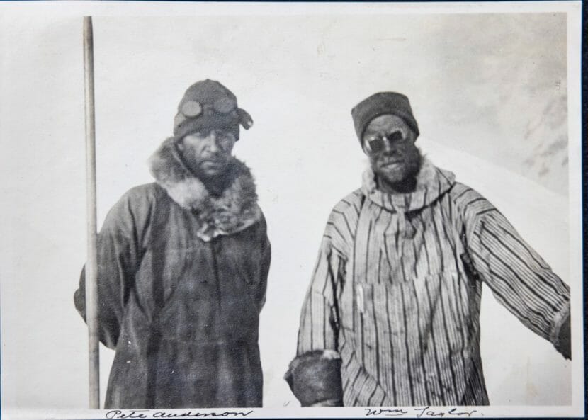
In this photo, previously unpublished as far as is known, Charlie McGonagal, left, and Pete Anderson, two of the four-man Sourdough expedition that ascended Denali’s North Peak, are shown in a mislabeled photograph. (Photo from UAF Rasmuson Library archive)
Sturm says he came across the Sourdough expedition photos in October while doing research for an unrelated mountaineering book at the UAF Rasmuson Library archive. He says he was looking through a box of materials and found a folder with a label that included the words 1911 McKinley climb.
He said he “got a tingly sense that maybe something good could come of this,” even though the date on the folder was off by a year.
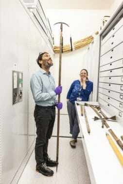
Museum of the North Director Pat Druckenmiller and Senior Collections Manager Angela Linn with the alpine stock used by Pete Anderson and Bill Taylor 1920 ascent. (JR Ancheta/UAF-GI)
Sturm says one of the photos in the folder shows two climbers he immediately recognized.
“I’m a bit of an amateur history buff for climbing in Alaska and the Yukon, and I thought — whoa, that’s Charlie McGonagall and Pete Anderson from the Sourdough climb,” he said.
Sturm says he worked with University of Alaska Fairbanks archive and Museum of the North staff to confirm the identities of the pictured Sourdough climbers, including Taylor and Anderson, who he says made it to the north peak’s summit.He says he figured out where the photos were taken by comparing them with modern images of the mountain.
“We could place them quite high on the route,” he said. “The highest one is near around 16,000 — and we’d never been able to place them anywhere near that before — for marvelous sort of insight into an event that has been revered by some climbers and doubted by others for a hundred and ten years.”
Sturm says the photos add to another piece of evidence that the Sourdough expedition climbed Denali’s North peak: a spruce flag pole the climbers set up a little below the summit, which members of the 1913 Hudson Stuck expedition reported seeing. They were the first to reach the top of Denali’s higher south peak.
A climber is seen in the distance at about 13,000 feet on what today is known as Karstens Ridge. Indentations to the left are believed to be from a 14-foot spruce flagpole. (Photo from UAF Rasmuson Library archive)
“I think it moves it from shadowy, maybe it did or didn’t happen, right into the mainstream,” he said. “It happened.”
Sturm says the Sourdough expedition photos were donated to the UAF archive in the 1980s by the daughter of an early 19 hundreds Fairbanks newspaper editor who was friends with Sourdough expedition climber Billy Taylor.
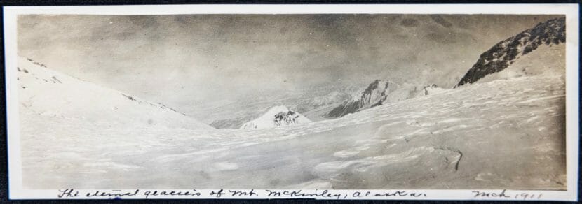
This photograph, made at about 16,500 feet, looks down the 20,310-foot mountain. Matthew Sturm and colleague Philip Marshall used maps and digital software to pinpoint the locations where the photographs were made. This photo is mislabeled as March 1911. (Photo from UAF Rasmuson Library archive)
“She donated a lot stuff to the archives, and they logged it in, and it would have taken an expert to know what it was,” he said.
Sturm says it remains a mystery why the photos weren’t used by expedition members to prove their summit claim. Sturm plans to write an article for a mountaineering journal about the photos.
Close
Update notification options
Subscribe to notifications
Subscribe
Get notifications about news related to the topics you care about. You can unsubscribe anytime.