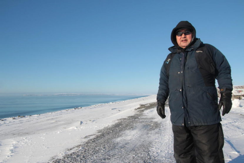
Eugene Asicksik, on the berm he and others built between village and the waters of the Norton Sound: “At least we try and defend ourselves and maybe give us more time to beat the storm back a little.” (Photo by Isaac Kestenbaum/Frontier of Change)
“Twenty years from now, this place would probably be under water,” says Rhoda Asicksik, who lives in the western Alaska coastal village of Shaktoolik. “That’s what really, really concerns me.”
Asicksik and most of Shaktoolik’s 350 residents want the federal and state governments to move the community away from the barrier spit on which it’s built – and which is in danger of being engulfed by the ocean or being swamped by waves driven by powerful storms.
“It’s so scary — too scary — to live here in Shaktoolik, because we have virtually no way of escape.” Asicksik said.
Her husband, Eugene Asicksik, Shaktoolik’s mayor, believes the best short-term solution is to improve infrastructure and build a mile-long berm the locals built on the seaward side of the village that he recently showed to a visitor.
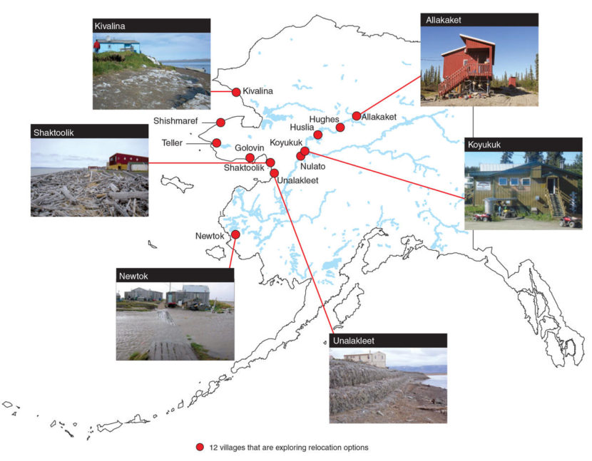
Shaktoolik, Newtok, Shishmaref and Kivalina are generally considered most at-risk of coastal erosion, flooding and other climate change-related damage. They’re among at least 12 Alaskan villages that are considering relocation or other strategies. (Public Domain photo by NOAA)
“We’re standing on the berm now,” Eugene Asicksik told a documentarian during a visit to Shaktoolik and other Alaska Native villages earlier this year. “The berm goes all the way past the dump. At least we try and defend ourselves and maybe give us more time to beat the storm back a little.”
Shaktoolik is one of four coastal Alaskan villages considered most at-risk from such climate-change impacts as receding sea ice, rising sea levels and powerful storms. Newtok, Kivalina and Shishmaref all are working to relocate to safer locations. Shaktoolik has opted to stay where it is – at least, for now.
“Basically what we’re trying to stop now is becoming an island,” Eugene Asicksik said in a telephone interview last week.
Asicksik says he and other locals built the berm in 2014 after years of working with bureaucracies more accustomed to dealing with the aftermath, rather than the lead-up, to disaster. Like the one that’s eating away at the sandy spit on which Shaktoolik was built in 1967, after an earlier relocation.
“We’ve already lost 50, 60 feet, since we relocated here,” he said.
That, combined with the worst-case storm surge scenario, worries Joel Niemayer, federal co-chair of the Denali Commission, which President Obama tapped to coordinate a response to the threat.
“That just terrifies me,” Niemayer said. “It just terrifies me.”
Editor’s note: many thanks to independent producer Isaac Kestenbaum for sharing excerpts of his interviews with Eugene and Rhoda Asicksik, conducted as part of the Frontier of Change project.
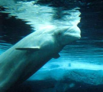
Beluga coming to the surface to breathe. (Creative Commons photo by Eva Hejda)
The Alaska Ocean Observing System recently rolled out a new information hub that’s all about beluga whales. The Cook Inlet Beluga Ecosystem Portal is a one-stop shop for beluga data that its creators hope will help scientists and the public make more informed decisions in the future.
From aerial views of Alaska’s coastline to environmental data to social statistics, the new beluga ecosystem portal has a lot of information.
“So, the intention of the portal is to provide a user-friendly location that anybody from a researcher to an environmental manager to the general public can go and access information that’s freely available,” said Stacey Buckalew, a project coordinator with Axiom Data Science, which she described as a technical arm of the Alaska Ocean Observing System (AOOS). “It puts it in a user-friendly interface so you don’t have to be an expert in GIS or computers to be able to navigate the portal.”
The portal collates data from a number of sources.
Beluga whale populations have been on the decline in Cook Inlet for many years.
“It pulls information primarily from a Cook Inlet beluga whale siting database that was funded by the National Marine Fisheries Service (NMFS) that integrates about 10 years of their aerial surveys of beluga whales as well as land-based beluga whale surveys by a number of other projects,” Buckalew said.
The portal also includes environmental data not specific to whales, like ocean temperature trends over time, water salinity stats and more.
“We are expecting that it’s really going to help with ecosystem-based management,” said Holly Kent, Director of Administration and Outreach for AOOS. “Like, well, where do the beluga normally hang out? And what time of year and what kind of ocean conditions are happening when they’re in this particular area? That might help us to make a plan about when we should have ship traffic going by, for instance, or something like that.”
There are a few stakeholders AOOS hopes will be able to use the portal immediately, like the Alaska Coastal Impact Assistance Program, Alaska’s Comprehensive Wildlife Conservation Plan, and the National Fish Habitat Action Plan, among others.
Online information hubs like this one have been gaining in popularity in recent years for groups like these, said Buckalew.
“It’s a new way that we’re accessing technology in the scientific world and also in the public arena as there’s so much information available,” she said.
For Kent, it’s a step in the right direction from the days of calling agency after agency asking the same questions over and over again and poring through books and papers to find information.
“So, it could take weeks or months to get all that information together. But now, anybody at an agency or anywhere else can go right to our website and they can do all of that. They can look at it, they can download it. It’s a huge time saver and it also shows information that maybe people didn’t know existed,” Kent said.
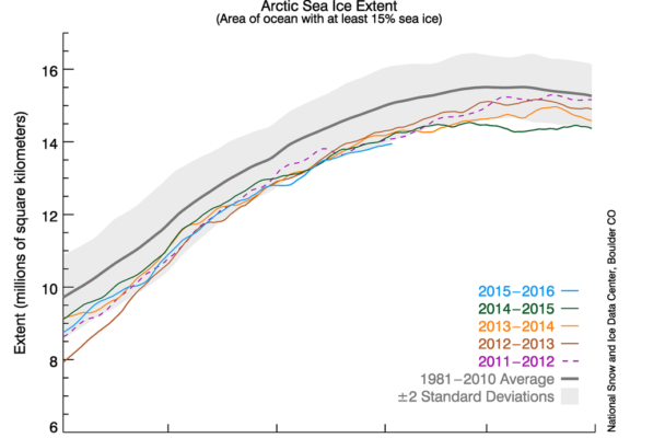
The graph above shows Arctic sea ice extent as of February 3, 2016, along with daily ice extent data for four previous years. (Image courtesy of the National Snow & Ice Data Center)
The satellite used to record sea ice data in the Arctic malfunctioned in April, and scientists are scrambling to calibrate a month of missing data.
In mid-March, the National Snow and Ice Data Center reported the lowest maximum sea ice extent in satellite history.
“It was a record low in our satellite record, which is quite consistent,” explained NSIDC lead scientist Ted Scambos. “We work on it a lot to make sure we can compare it, one year to the next.”
NSIDC first started recording sea ice data in 1978.
Julienne Stroeve is an NSIDC scientist who studies sea ice conditions in the Arctic. Stroeve said she and her fellow scientists noticed a glitch in their data in early April.
“We started getting false ice concentrations in parts of the Arctic where you wouldn’t have sea ice,” Stroeve explained, “so it was biasing our extent.”
“The good news is they’ve found another satellite in that same type of series,” confirmed Amy Holman with the National Oceanic and Atmospheric Administration. “They believe the data (are) compatible enough that we can continue the data record,” Holman said.
The satellite Holman is referring to has been recording sea ice data for a year now, which Julienne Stroeve said should be enough time to cross-calibrate. Consistency is key, Stroeve said.
“You want as long of a data record as possible to really see how much this change we’re seeing is due to natural climate variability, for example, or how much is due to anthropogenic warming.”
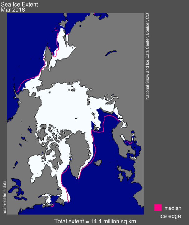
Arctic sea ice extent for March 2016 was 14.43 million square kilometers (5.57 million square miles). The magenta line shows the 1981 to 2010 median extent for that month. (image courtesy of the National Snow & Ice Data Center)
To help make that distinction, NSIDC captures an image of sea ice extent in the Arctic every day and posts daily updates online. The agency has since suspended the updates and removed all of April’s data from NSIDC’s archives.
While the malfunction was a bit of a shock, Stroeve said it was bound to happen.
“It wasn’t surprising that this happened because the satellite was pretty old,” Stroeve said, “so eventually the sensors do degrade and start giving bad data.”
The satellite that malfunctioned was launched 10 years ago. The one they’re relying on now was launched nine years ago. Stroeve said there is a backup to this backup, but that one is still on the ground.
“Congress took away the funds for the Air Force to launch it, which is very unfortunate,” Stroeve said. “Obviously, we’re hoping that pressure can be put on Congress to launch that other satellite.”
For now, Stroeve and her colleagues will continue cross-calibrating data, with the hopes that the one they’re using now will stay online until Congress approves funding for the next series of satellites.
It begins with a growl. Then there’s a crack — a slurpy, sucky, crunchy noise. A guy is on the phone, and his pal interrupts him and says, “It’s starting, Adam, I think. Adam? It’s starting …” The two are up on a bluff, overlooking a giant ice field. They are standing next to time-lapse cameras. What happens next is astonishing: An enormous frozen, icy hunk of our planet suddenly opens, splits into bits and then sinks right before our eyes into the sea. It happens so, so quickly. And the scale of it? That’s the part that shocked me. When they superimpose part of Manhattan Island onto the ice at the end of the clip, you think, “Uh oh.” This is a peek into something monstrous.
The video comes from photographer James Balog’s film, Chasing Ice. The two guys on the bluff at the beginning are part of Balog’s Extreme Ice Survey team, which maintains scores of time-lapse cameras overlooking glaciers in Greenland, Iceland, Alaska, Canada, the Rockies and the Himalayas. During daylight hours, they watch and record. Then they share what they see with scientists and National Geographic, and turn the footage into movies and TV shows.
Losing All The Ice In The World? Let Me Calculate …
What they’re seeing, of course, is ice disappearing from mountain tops, from ice fields, from the poles. Seeing it go this quickly in so many places, raises the obvious question: How long will it be before there isn’t any ice left? We’ve had such moments before in earth history; it’s certainly possible. We have lived in a gentle age where, every winter, one can take a trip to someplace white to see a snowy mountaintop, a distant glacier creeping down a slope, or an iceberg in the distance. Come summer, the whiteness retreats. It’s a lovely balance. But how long will that last?
When Henry Pollack (a professor emeritus of geophysics at the University of Michigan) was asked, he answered, “Losing all the ice in the world? I think sometime between a thousand and 10,000 years encompasses most probabilities.”
A thousand years is not a lot of time. As Craig Childs says in his book, Apocalyptic Planet, 10 centuries ago Europeans were busy building cathedrals. Chinese merchants were sending flotillas to trade with Africans. “I was thinking we had more time,” Craig says.
Konrad Steffen thinks Craig is right. A University of Colorado climatologist, Steffen figures (or figured, a couple of years ago) that Greenland might be iceless in 10,000 years, but Antarctica (being much bigger) will take a lot longer to turn bare.
But that’s an endpoint. It’s the middle passage that has so many scientists worried. Steffen tells Childs, “Greenland and Antarctica are very remote, and were considered to be big ice boxes that responded not very fast to climate change. We never developed a mechanism to observe them until we had satellites and lasers. Now we see some surfaces lowering up to 50 meters per year.” He repeated that number, to make sure Craig heard. “Fifty — five-zero — meters per year.” That’s a vertical drop of about 150 feet. In two years, that’s 300 feet. Then 450. Year after year — enormous piles of ice melting into the sea.
A lot of water. Coming our way.
Copyright 2016 NPR. To see more, visit http://www.npr.org/.
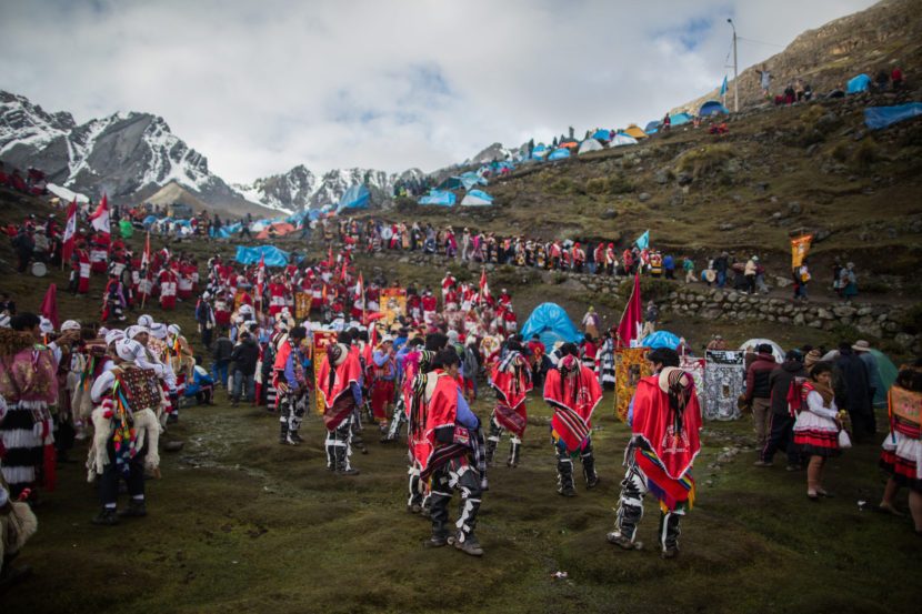
The yearly festival is called Qoyllur Riti — Snow Star in the Quechua language. Wearing traditional garb as well as special outfits made for the event, worshipers travel many miles by truck, then face a steep six-hour hike to get to the site. Sebastian Castañeda Vita
On Sunday, May 22, over 100,000 Peruvians are expected to arrive at a site in the Andean highlands near the peak of Ausungate, in the southeastern region of Cusco. They may have traveled hundreds of miles to get there. At an altitude of 16,500 feet, they’ll camp out, sing, dance and pray at the holiest — and one of the biggest — religious festivals in the Andes mountain chain. It’s called Qoyllur Riti, which means “snow star” in the local Quechua language.
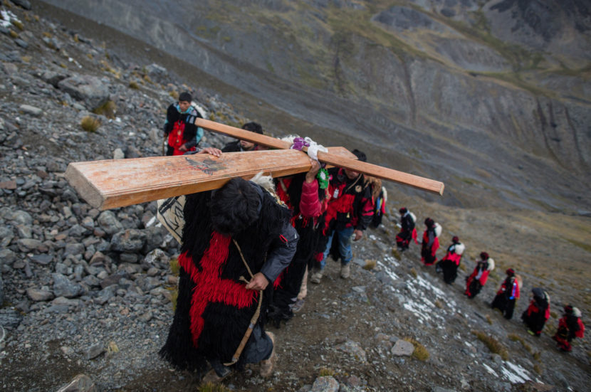
These days, the festival is an example of how climate change is affecting far more than daily life and agriculture. The mountains here are considered sacred by the worshippers and known as “apus,” or mountain spirits, gods. The tradition is for each province represented at the festival to carve out heavy chunks of ice from the glacier — symbolic of water and life — to bring back to their communities.
But things have changed.
“We can’t take snow down from the glacier anymore,” says Walter Mamami, a participant from the Canchis province. “The glacier is getting smaller. We now stop at the foot of the glacier.”
Each province represented at the festival used to carve out heavy chunks of ice from the glacier — symbol of water and life — to bring back to their communities. Sebastian Castañeda Vita
The festival itself is a combination of native and Catholic traditions. It celebrates the reappearance of the Pleiades constellation in the night sky, marking the start of the Andean new year and the harvest season. There’s a Christian context as well: According to a legend, in 1780, a fair-skinned boy appeared to a young shepherd who lived in the mountains, then turned to stone when suspicious villagers came after him. The belief is that the boy was Jesus.
That was a time of tension between the local peoples and Spain, which ruled Peru from the 16th century until the 1820s. Spain tried to quash the Indian language and culture. But in the case of the festival, the two cultures, Spanish and Andean, became intertwined.
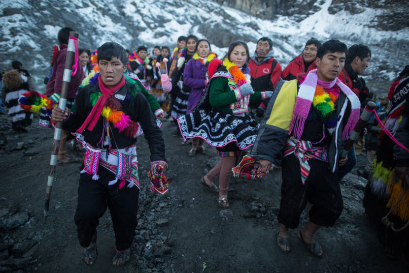
I visited the festival last year, following a group of official guardians of the Qoyllus Riti tradition, known as pablitos in Spanish or ukukos in the local language.
The pilgrimage itself is a test of endurance, a penitence of sorts. It takes days to arrive as villagers travel in open trucks most of the way, stopping in every village along the way to pray, dance and sing. There’s lots of coca-leaf chewing and nonstop music to keep the deeply devoted pilgrims going with little or no rest. Worshippers disembark in Mahauyani, the furthest trucks can go, before hiking another six hours to cover the final steep 6 miles to their destination.
The festival has both native and Catholic traditions. Sebastian Castañeda Vita
On the vast plain in the glacial basin of Sinakara, surrounded by snow-covered peaks, a cacophony of round-the-clock music and prayers blares from loudspeakers at the chapel on the site. People come wearing their community’s traditional dress as well as special outfits made for the festival. “Hairy” woolen robes worn by the ukukos are a reminder of a mythical bear, believed to live in the surrounding mountains. Meanwhile colorfully dressed male dancers bounce around carrying what looks like a stuffed baby llama on their backs.
“The glacier receded a lot,” Jaime Rios Farfan, from the Acomayo province, told me after he returned from the main ritual at the foot of the glacier — 1,500 vertical feet higher than the camp site — held at sunrise. “We prayed and asked Apu Qollqupunko [the name of the peak], that the glacier not recede any more, that it not disappear.”
At the celebration in years past, each community had its own area in the snowfields where it would carry out its rituals and prayers. Participants from the province of Paucartambo said only muddy land remains in its reserved area.
“It’s a sad reality,” says Rios Farfan.
If and when the glacier disappears, “It will threaten peaceful coexistence between the groups,” says Javier Felix, an anthropologist, speaking of possible tensions between those communities that might still have a sacred area on the glacier and those that don’t.
He lamented that many of the younger “guardians” didn’t appear to understand the importance of the glaciers to the spiritual traditions. “The elders understand,” he adds.
What the elders can’t understand is why no one seems to care about earth’s changing climate.
“The big factories and all the garbage are destroying the ozone layers. Over here while it used to be all white, there are more and more rocks,” admits Rios Farfan.
Indeed, last year at the festival, local chiefs criticized the world’s disrespect for Mother Nature.
Copyright 2016 NPR. To see more, visit http://www.npr.org/.
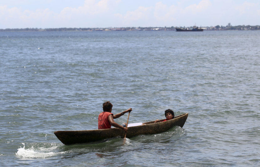
Two young men ride in a dug out canoe just off shore in Honiara, Solomon Islands, in 2012. Rick Rycroft/AP
In what is being billed as a “window into the future impacts of global sea-level rise,” scientists have documented how the ocean swallowed up five small islands that were part of the Solomon Islands archipelago northeast of Australia.
The six Australian scientists combined satellite images and interviews with locals to examine 33 islands. They found that during a period from 1947 to 2013, five vegetated reef islands had disappeared and six other islands had severe shoreline recession. Two villages have been destroyed and Taro Island, which is inhabited, is likely to become “the first provincial capital globally to relocate residents and services due to the threat of sea-level rise.”
“‘The human element of this is alarming. Working alongside people on the frontline who have lost their family home — that they’ve had for four to five generations — it’s quite alarming,’ the study’s lead author, Simon Albert of the University of Queensland, told CNN.
“… The Solomon Islands are a sparsely populated archipelago of more than 900 islands that lie east of Papua New Guinea, and as low-lying islands are particularly vulnerable to sea-level rises.”
“In March, James Hansen, a NASA scientist who is extremely influential in the study of climate change, estimated that seas could rise by seven meters in the coming century, a figure that would likely decimate coastal communities, if proved accurate.
Losing Ground, a report issued by the nonprofit news organization ProPublica in 2014, demonstrated that large swaths of the Louisiana coastline are being lost to rising sea levels, and a 2011 study conducted by the U.S. Geological Survey determined that the state’s wetlands were being lost at a rate of “a football field per hour.” South Florida, the Carolinas, and the Jersey Shore are also in danger of losing land due to sea level rise, according to an interactive map created by Climate Central, an organization of scientists.”
Discovery reports that in the Pacific, the rise has been “in the 3 to 5 millimeters per year range.”
Copyright 2016 NPR. To see more, visit http://www.npr.org/.
Close
Update notification options
Subscribe to notifications
Subscribe
Get notifications about news related to the topics you care about. You can unsubscribe anytime.

9(MDEwMjQ0ODM1MDEzNDk4MTEzNjU3NTRhYg004))
9(MDEwMjQ0ODM1MDEzNDk4MTEzNjU3NTRhYg004))
9(MDEwMjQ0ODM1MDEzNDk4MTEzNjU3NTRhYg004))
.jpg)