Climate Change

Northwest Passage cruise marks turning point in Arctic tourism

Crystal Serenity at North Cape in Norway
The Crystal Serenity at North Cape in Norway. (Photo courtesy Crystal Cruises)

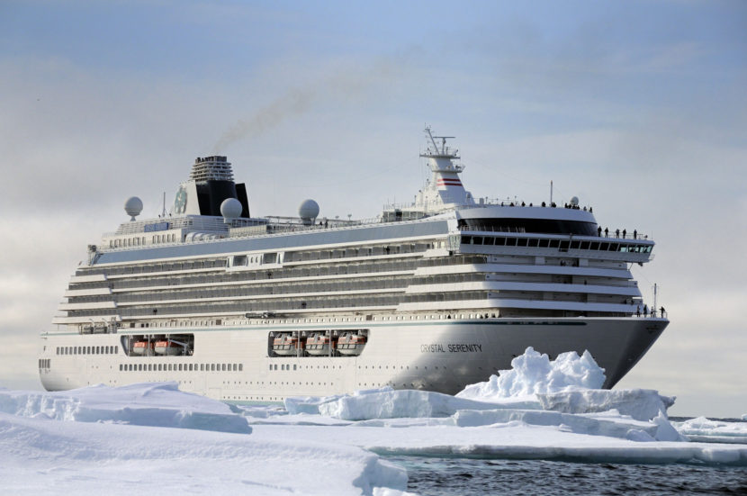
On Aug. 16, the Crystal Serenity will steam out of Seward on a historic trip. The vessel will be the first big luxury liner to chart a course through the Northwest Passage, stopping in Kodiak, Unalaska and Nome before cruising through Canada’s far north to Greenland and then south to New York. The unprecedented voyage is generating excitement — and trepidation.

Cruise ships have been plying Arctic waters for years, but the Crystal Serenity will be the largest by far to chart a course through the Northwest Passage. The luxury ship will carry more than 1,000 travelers and 620 crew members on a journey that will take an estimated 32 days, and comes at a cost of $21,000 per passenger.

It marks a turning point for tourism in the Arctic, which has seen a steady increase in ship traffic as a warming planet yields more and more ice-free water in summer.

For some, it’s an exciting shift. In Nome, Harbormaster Lucas Stotts said there’s a lot of enthusiasm for the arrival of the ship, which will actually have to moor offshore, as it’s too big for the harbor.

“For us, 800 to 1,000 passengers is an awful lot of folks coming ashore when we’re used to seeing the pocket-sized cruise ships or the expeditionary cruises that have anywhere between 100 and 200 people on board only,” Stotts said.

Others are looking on the unprecedented trip with some caution.

David Aplin with the World Wildlife Fund’s Arctic Field Program said the region has opened up to traffic so rapidly that he’s concerned our reach there is outstripping our understanding of the place.

“As the ice recedes and we create a new ocean at the top of the world, what we’re finding worldwide is that we’re unprepared for that increase in shipping traffic,” he said.

Aplin and others say safety is the biggest concern when it comes to Arctic travel. Insurance company Allianz Global keeps tabs on international shipping, and its latest report shows that Arctic travel is relatively risky. Losses at sea dropped overall last year, but because of new traffic, the number of incidents in the Arctic jumped to 71 —  a nearly 30 percent increase. It’s a decade high.

And mounting a mass rescue operation thousands of miles from the nearest deepwater port is difficult. Same goes for containing oil spills. The Coast Guard has been planning for a potential mass casualty event in the Arctic for years and is planning a drill near Nome, though it won’t happen until after the Crystal Serenity departs.

There are other concerns about impacts to a fragile and stressed Arctic environment, and to the Native communities who rely on it.

Andrew Hartsig is the director of the Ocean Conservancy’s Arctic Program. He said cargo ships are usually looking for the shortest, easiest routes, but that’s not necessarily the case for cruise ships.

“A tourism company is often seeking out the very places that are kind of most dramatic or seeking out congregations of animals, because that’s what the passengers want to see,” Hartsig said.

John Stoll, the Crystal vice president in charge of managing the Northwest Passage voyage, said the company has been carefully planning this trip for three years. The ship has been outfitted with new ice-detecting equipment, including forward-looking sonar and thermal imaging technology. And once it’s in Canadian waters, an icebreaker on loan from Great Britain will act as a support ship, sending up helicopters for real-time ice recon. The RRS Ernest Shackleton will also carry emergency rations and a team of experts guides who will run special Zodiac expeditions for guests.

“We want to be the cruise line that sets the example for how to do this and how to do it right,” Stoll said.

He said Crystal has also planned carefully to minimize impacts. They’ll be exceeding international guidelines on wastewater discharge, he said, and they’ve been working with the tiny Arctic towns they’ll visit to make sure they won’t overwhelm the communities.

“I think Crystal from this standpoint has an obligation to do what we can to introduce the world to this part of the world,” Stoll said. “It’s phenomenal and it’s something that people shouldn’t miss.”

Still, some are concerned about what Crystal’s trip heralds. Austin Ahmasuk is with the Kawerak Corporation’s Marine Program, which aims to give a voice to Native villages as the world continues to talk about increasing Arctic traffic. He said there’s reason to worry about tourism’s impacts on subsistence resources.

“People in northwestern Alaska, on the coast, we’ve been mariners for a very long time and we make substantial use of the marine environment for subsistence food items, for culture, for living,” Ahmasuk said. “And it is very important to us..”

Despite that, Ahmasuk said, it’s easy for Native communities to be left out of the conversation about the opening of the Arctic.

“We want to make sure that the environment is not damaged, we want to make sure that our communities are able to sustain themselves, and we want to be able to participate in some decision making,” Ahmasuk said.

When it comes to this trip, Hartsig and others said Crystal Cruises has done a solid job of planning. They said they worry about other operators who’ll come along later.

It’s a mixed bag, Hartsig said. The only reason tourism can happen so far north is because of a warming climate, but maybe that fact will inspire visitors to care more about the environment.

“For a lot of people, the Arctic is out of sight and out of mind, and if you have vessels like this taking people up to the Arctic to see firsthand this environment that maybe being an optimist about it, maybe that will be the thing that really registers with people,” Hartsig said.

There is, at least, a lot of interest. According to Crystal, the Serenity is sold out for this sailing and is filling up for another trip in 2017.

Smartphone apps encourage local involvement in a changing climate

Screenshot of observations from the LEO Network. (Image courtesy of Mike Brubaker)

A handful of apps is making it easier for rural communities to report on climate change in Alaska. With a swipe of a smartphone, locals can submit environmental observations, and there’s even an app aimed at preventing further change.

Mike Sloan pulls his smartphone out of his pocket. It takes a few seconds, but finally, the LEO Reporter app appears on his screen.

“Slow internet…” Sloan explains.

The screen on his smartphone shows the state of Alaska speckled with different colored dots, each representing a different observation.

Because we’re in Nome, it automatically zooms into an aerial view of the town. Sloan taps on a little light blue dot just off the coast. It’s a post from January 1, 2013.

“Actually, it was a post I did,” Sloan admits.

Sloan is the Director of Tribal Resources for Nome Eskimo Community. He’s also a Local Environmental Observer or LEO.

The Alaska Native Tribal Health Consortium created the LEO Network back in 2012 as a way for locals to document unusual environmental events like coastal erosion, wildfires, or even stranded snowmachiners.

“We had a strong winter wind that broke off the sea ice in front of Nome and moved it offshore [and] there was a snowmachiner trapped on the ice floe,” Sloan explains, adding “they were able to save him.”

After Sloan submitted his observation to the LEO Network, it was then tagged with a similar event in the Canadian Arctic. Sloan says the LEO Reporter app makes it easy for anyone to connect the dots, more specifically across Alaska.

“Say, if we have bird die-offs in Kodiak, we can go to LEO, look for bird observations, and it will pull up any other bird observations around the state.”

Five-hundred miles southwest of Nome, residents of St. Paul Island in the Pribilofs are using a similar app. It’s called the Bering Watch Citizen Sentinel App. Pamela Lestenkof co-directs the Ecosystem Conservation Office on St. Paul Island.

“Back in St. Paul, it’s our hunters, our beachcombers, and our fishers,” Lestenkof explains, “they’re the ones that are out there on the land, so they’re the first [that would] see a stranded marine mammal or dead birds.”

Locals have been sharing observations on Facebook for years, so Lestenkof says a database of those observations just made sense.

“And then once it’s uploaded in our database, we can publish it to Facebook,” Lestenkof says, “so there’s incentive for them to share it.”

But not all apps are aimed at observing changes. Gino Graziano helped develop one aimed at preventing them.

“Let’s see here… where did I put it?” Graziano says as he swipes through his smartphone. “There it is. It’s Alaska Weeds ID.”

Graziano teaches classes on invasive species at UAF’s Cooperative Extension Service in Fairbanks. He and his colleagues teamed up with the US Fish and Wildlife Service and the University of Georgia to develop the Alaska Weeds ID app that helps people identify weeds native to their area and report non-native or invasive ones.

The app takes you through a series of descriptors, like leaf shape and leaf arrangement.

“And then, it will ask if the leaves are smooth or do they have little teeth or spines on them or hairs,” Graziano says.

Finally, it asks about flower color and flower arrangement.

“And you end up with what type of species it is. So, we end up with a couple of different options and we can pick bird vetch from that,” Graziano says as an example.

If you do come across an invasive plant like bird vetch, which has invaded Alaska’s interior, you can send a report with a photo, description and location directly from your phone.

“And then a message actually goes to me,” Graziano admits.

If the plant is a serious threat and on public property, Graziano would contact a local land manager to remove it. Western Alaska is still largely free of invasive species, and Graziano hopes this app helps keep it that way.

“That’s really the key to invasive species management—is getting on it early,” says Graziano.

Ultimately, that’s what all these apps are hoping to do. Climate change is already affecting western Alaska, but locals can now help document those changes and, with the help of their smartphones, be more aware of what’s to come.

What these drones have detected could mean hazards for the Bering Sea

Saildrones Inc. CEO Richard Jenkins turns his back (unwisely?) on two of his creations in Unalaska. Photo: John Ryan/KUCB.
Saildrones Inc. CEO Richard Jenkins turns in Unalaska. (Photo by John Ryan/KUCB.)

Orange drones were launched in Dutch Harbor last summer to measure sea ice retreat. Now Saildrones are back in the Bering Sea with a new mission and new features.

One of them is to record North Pacific right whale calls to help track its migratory patterns. There are only 30 North Pacific right whales in U.S. waters. The other new feature will help determine how many fur seals and pollock live in parts of the Bering Sea.

The pollock fishery there is the largest in the U.S.

“Is it going to be a winner or a loser over the next decade in terms of the effects of warming, ocean acidification and loss of sea ice?” asks Douglas DeMaster, a science director at the National Oceanic and Atmospheric Administration Alaska Fisheries division.

DeMaster says scientists are concerned about the fur seals, which feed on pollock, and the diminishing stocks of pollock.

“It’s something the fishery needs to plan for and adapt to. And the only way to do that is with good information,” DeMaster said.

https://vimeo.com/167481038

In addition to testing the temperature, oxygen and salinity of the water, the Saildrone will also be using echo sounder technology. DeMaster calls it “a sophisticated fish finder.”

“It’s basically a ping, a sound impulse that’s sent through the water column and it’s reflected off of fish,” he said.

NOAA has used it on research vessels before but never on the Saildrone. Scientists will be able to sit from the comfort of their office or even in a coffee shop, as some of the data is collected in real time. In September, they’ll pluck the Saildrones out of the water when the season changes. They run off battery and solar power. It’ll take six months to a year before scientists can draw solid conclusions from the data.

Christopher Sabine, the director of NOAA’s pacific marine environmental lab, says pollock stocks have dropped before. The temperature of the Bering Sea warmed up in the early 2000s.

“Then it got cold again and the fish stocks came back,” Sabine said. “We’re now swinging back into a warm period again and we’re looking at potentially three years for this to manifest itself in the fisheries side of things.”

Since the Saildrone were launched two weeks ago, some startling information has already come back. Sabine says temps in the lower Bering Sea are about five degrees warmer than normal.

Activists remember oil and gas buyback in Kachemak Bay

The Homer Spit on Kachemak Bay.
(Photo courtesy of KBBI)

The environmental nonprofit Cook Inletkeeper sponsored a panel discussion to commemorate the 40th anniversary of the Kachemak Bay oil and gas lease buyback. The buyback prevented oil and gas development in the Bay and protected it as a critical habitat area.

“It was a story. It was a David and Goliath; a little town in Homer at the end of the Sterling Highway, is under pressure from those big oil companies,” said Frank Tupper, who helped found the Kachemak Bay Defense Fund.

In one corner was David: a motley crew of commercial fisherman, Homer’s budding environmental movement — including Tupper — and other Homer residents desperate to protect Kachemak Bay. In the other were oil companies and the state of Alaska, which in December 1973 held a Lower Cook Inlet lease sale that opened up the bay to drilling and production activities.

What followed was a three-year battle fought in all three branches of state government and all aspects of the community. On May 25, Cook Inletkeeper sponsored a panel discussion to commemorate the 40th anniversary of these events.

“It was a local, human-scale fight over our human destiny with great characters and great arguments on all sides,” said Tom Kizzia, editor of the Homer News at the time,” said journalist, Tom Kizzia.

“Homer really changed as a consequence of what happened in that period. I think you can see a lot of what Homer became, was seeded and started to grow at that time,”

The seeds of environmentalism flourished from the fight, and the community became centered on tourism and fisheries, rather than oil and gas.

Loren Flagg was the commercial fisheries area biologist for Fish and Game when the lease sale was announced, and had all of two days to prepare comments.

“At that time the bay was producing 5 million pounds of shrimp a year, 2 million pounds of king crab, a half million pounds of tanner crab, and, of course, salmon, halibut. It was extremely, extreme(ly) valuable resources,” said Flagg.

But Gov. Bill Egan supported the sale, so it went ahead, much to the surprise of Homer residents. The sale had been announced through the usual governmental and industry channels, but not in a way that reached community members. Ken Moore fished crab, herring and salmon in the bay. He says fishermen felt like they didn’t have a say in the matter.

“No effort to find out if the people whose front yard it was all going to be in wanted it there. Or it didn’t seem that anybody really cared whether they did or not, it had happened already. And that just added insult to injury when you discovered what was going on,” said Moore.

Frank Tupper was making ends meet as a self-proclaimed hippie at the time, when a friend came by his trailer to tell him about the pending lease sale.

Frank Tupper was one of the founders of the Kachemak Bay Defense Fund. (Photo by Jenny Neyman/KBBI)
Frank Tupper was one of the founders of the Kachemak Bay Defense Fund.
(Photo by Jenny Neyman/KBBI)

“Neither one of us could believe that that would be possible, that people were not that stupid, that they wouldn’t just do it just for the dollars. Naïve we were, but, still, that’s what we thought because of this beautiful, intrinsic area that we live in. So I think I said to Chuck, ‘Well, dammit, there’s two of us, let’s get going.’ From the citizen side of it that was the beginning of going out and just beating the streets and talking to people, ‘Do you know what’s coming, do you know what’s coming?’” said Tupper.

Such was the grass roots of the community campaign that eventually gained national attention. Activists established the Kachemak Bay Defense Fund, led by Tupper. They joined forces with the North Pacific Fishermen’s Association, led by Moore, to spread the word of the oil incursion into the bay and raise money for a legal battle.

A popular tactic was to hold shrimp and crab feeds, serving up information and donation forms along with the shellfish.

“I would hold up a quart of oil and I would say — after they were wiping their mouths with the butter and the garlic and everything — I said, ‘Now, which would you prefer in the bay?’” said Tupper.

The fund helped pay for legal challenges to the leases. The issue made it to the Supreme Court. Warren Matthews was an attorney for the plaintiffs. They brought three challenges: Failure to give notice — they lost on that one; failure to make a reasoned decision that the lease sale was in the best interest of the state; and failure to conduct a study of potential impacts to be shared with affected communities. The court found merit in those two claims, but not enough to reverse the sale.

“A majority of the court said, ‘Well, you’re right, but do we want to disturb all these other leases that have been made in the past?’ They answered, ‘No. Therefore, we’re not going apply this ground to you, either,’” said Matthews.

But political tides were changing. Republican Jay Hammond was elected governor in 1974, in part on his conservationist platform to protect fisheries.

Homer fishermen, environmentalists and others had been fighting to protect Kachemak Bay from development after the state of Alaska held a lease sale for oil and gas exploration.

“We were fighting for our homeland; we were fighting for the bay, the intrinsic beauty of the area. So it wasn’t just a bunch of people with an ‘ist’ at the end — conservationist, environmentalist, developmentalist. It was people. People from a little town that had a common goal, and we fought like hell,” said Frank Tupper, of the Kachemak Bay Defense Fund.

Tupper’s group raised money to bring a legal challenge to the leases. Though the Supreme Court agreed with some of their arguments, it offered no practical relief, not wanting to step on a slippery slope that could affect many other leases already issued.

That left the state’s lawmakers and administration to settle the issue. Gov. Hammond submitted a bill to the Legislature in 1976 calling for a one-year moratorium on oil drilling in the bay, in which time the state could negotiate with the oil companies to buy back the leases. After that year, the state could reacquire the leases through eminent domain. Going forward, Kachemak Bay would be protected as a critical habitat area.

It was not an easy sell in the Legislature, with many Democrats still loyal to Gov. Bill Egan, who authorized the sale, or supportive of industry development in the state. Republican Legislator Clem Tillion, from Halibut Cove, was one of the main champions of the bill, both to protect fisheries and because the oil industry only paid 1 percent severance tax at the time. New legislation would impose taxes on the oil industry similar to what Texas required.

In his time in the Legislature, Clem Tillion helped pass a bill that protected Kachemak Bay from oil and gas drilling.
(Photo by Jenny Neyman/KBBI)

“Why would I give up one fish for something that doesn’t pay me anything? Those are my grandchildren and great-grandchildren’s resources. But I’m certainly not going to give it away,” Tillion said.

Chancy Croft was a Democrat lawmaker, but on the same side of the issue.

“By ’75 you had a Republican governor and a Legislature that was overwhelmingly Democrat. And, so, the question was, ‘Were a group of Democrats going to say that the former Democrat governor of Alaska was wrong in what he did?’ It turned out a majority were willing to say that,” Croft said.

As the clock wound down in the 1976 legislative session, Tillion was short three votes to get Hammond’s bill passed. Ironically, the oil industry provided the extra push needed.

The jack-up rig George Ferris had been towed to Mud Bay, along the Homer Spit, for repairs after it was damaged at Cape Kasilof early that year. By August, rumors were flying that the rig’s iron legs were stuck in the mud. In May, Shell Oil attempted to move the rig, but the legs failed to retract and the rig got swamped by the tide, spilling diesel fuel into the bay. The oil boom meant to contain any possible spills was stuck on deck. Another boom brought in to contain the spill turned out to be already dirty and released its own sheen into the water.

Kizzia, editor of the Homer News at the time, covered the fiasco.

“To this day you can find plenty of quotes from industry officials about the care that they were going to take if drilling went ahead. And as soon as there was actual trouble all the promises evaporated,” said Kizzia.

Most anyone on the fence about protecting the bay was pushed over by the resulting outrage.

“One of the biologists with Chevron testified that it would not be possible to spill enough oil to do harm in Kachemak Bay,” said Loren Flagg, the commercial fisheries area biologist for Fish and Game at the time. “As the Legislature was getting ready to vote, the George Ferris. And that was enough for the Legislature to change their votes.”

Homer was indelibly changed by these events, and those involved learned lifelong lessons.

“Trust but verify. Don’t take everything you hear,” said Flagg.

“Don’t give away that which lasts forever for something that’s going to be here a short time,” said Tillion.

“The belief in people power, in self-advocacy, in the strength that you as an American citizen has,” said Tupper.

The panel discussion panel discussion to commemorate the 40th anniversary the Kachemak Bay oil and gas lease buyback took place on Wednesday, May 25 at Islands and Ocean Visitor Center in Homer. Cook Inletkeeper plans to make a full recording of the discussion available on its website, at inletkeeper.org.

Editor’s note: In 2014, Soldotna Sen. Peter Micciche sponsored legislation that removed the area around the deep-water dock on the Homer Spit from the critical habitat area, allowing drill rigs to dock at the Homer port. Cook Inletkeeper objected to the change, but there was overwhelming political support and the legislation passed.

Bureaucracy slowing response to climate change ‘disaster events’

Decades of coastal erosion and storm surges have brought the Chukchi Sea to within a few feet of some homes, as shown in this 2010 photo. (Photo courtesy of State of Alaska)

Janet Mitchell says she and many others in Kivalina were encouraged last year when President Obama gave a shout-out to her village, and the peril it faces, after a flyover during his visit to Alaska.

“… On my way here, I flew over the island of Kivalina, which is already receding into the ocean,” Obama said in a Sept. 2 speech in Kotzebue.

Mitchell is Kivalina’s city administrator. She and others have been working for years to get state and federal agencies to help move the village to higher ground, where it won’t be threatened by flooding from waves whipped up during the powerful storms that slam into western Alaska late in the fall.

That’s what residents of Kivalina told Obama in one of the meetings he held with Alaskans during his three-day visit to the state, which he alluded to in the Kotzebue speech: “… The waves sweep across the entire island, at times from one side to the other.”

Mitchell says her Inupiaq forebears wouldn’t have built a village on the exposed site at the end of an 8-mile-long sandy island on the northwest-Alaska coast that’s barely above sea level. But she says the federal Bureau of Indian Affairs did that just over a hundred years ago because it seemed like a handy place for boats to offload supplies.

“This was the easiest spot to drop the material and build a school,” she said. “And we’ve been here ever since.”

Mitchell says it wasn’t long before the people of Kivalina began trying to move their community. She says state and federal agencies have provided some help, but that it seems they’ve just begun to learn how to respond to this new type of slow-moving disaster.

“Oh, very much so,” said Joel Niemeyer is the federal co-chair of the Denali Commission, which the president has tasked with overseeing the village-relocation effort.

“The failure mechanism … you could say is a disaster event over a long period time – not over hours, but over years,” Niemeyer said. “And there are no congressional authorities for that.”

Niemeyer says lessons-learned in places like Kivalina should enable those agencies to respond more ably in the years ahead, as more coastal communities face erosion and more powerful storm surges energized by a warming climate.

“What’s happening in Alaska is the start of climate-change effects,” he said, “and this could well be occurring in the Lower 48.”

Niemeyer says he hopes Congress will soon grant agencies additional authority so other communities won’t have to cope with both climate change and bureaucracies that aren’t prepared to respond to it.

“Weeks or months” before NOAA knows what killed whale

Carol Fairfield, Bureau of Ocean & Energy Management, takes samples during a necropsy of a fin whale in Resurrection Bay, Seward, Alaska. Jennifer Gibbins/Alaska SeaLife Center
Carol Fairfield of the Bureau of Ocean & Energy Management takes samples during a necropsy of the fin whale. (Photo courtesy of 
Jennifer Gibbins/Alaska SeaLife Center)

It could take weeks or months before scientists know what killed a fin whale stuck on the bow of a Holland America cruiseship. The whale carcass was found Sunday when the cruiseship docked in Seward.

Julie Speegle, spokesperson for the National Oceanic and Atmospheric Administration, says the endangered juvenile fin whale was about 50 feet long. It was moved to a nearby beach where a two-day necropsy took place.

Speegle said the lead pathologist took a number of tissue samples to determine the cause of death.

“Some of the samples she took were intended to be tested for exposure to harmful algal blooms, which means if those tests (come) back positive it could be related to the unusual mortality event of large whales,” Speegle said.

Last year, nine fin whales were found dead in Southcentral Alaska waters. Speegle said NOAA doesn’t know what caused the whale deaths, but algal blooms — caused by warming ocean temperatures — are the leading theory.

“The harmful algal blooms have a toxin in them that get into the phytoplankton, which the whales eat, which then introduces the toxin to the whale.”

Essentially, poisoning the whale.

Russ Andrews, Carol Fairfield and Laura Morse participated in the necropsy. The whale's body will be buried on the beach. Later, the bones could be dug up and re-articulated for display. (Photo courtesy of Jennifer Gibbins from the Alaska SeaLife Center)
Russ Andrews, Carol Fairfield and Laura Morse participated in the necropsy. The whale’s body will be buried on the beach. Later, the bones could be dug up and re-articulated for display. (Photo courtesy of Jennifer Gibbins/Alaska SeaLife Center)

Speegle says the fin whale discovered Sunday could have died from natural causes. A predatory killer whale could have harmed it, or it could have died from illness.

There’s also the possibility the cruise ship struck it at sea. Speegle says Holland America reported that they didn’t notice anything when they entered Resurrection Bay.

Holland America could not be reached for comment.

Site notifications
Update notification options
Subscribe to notifications