Chum salmon migration. (USFWS/Togiak National Wildlife Refuge)
In 2013, researcher Chris Sergeant was doing some routine water quality monitoring in Sitka’s Indian River when he noticed something strange on the oxygen monitor.
“It was getting close to zero — really, really low,” Sergeant said. “And there were fish dying off. Juvenile coho and cutthroat trout. And a high percentage of the adult salmon were hatchery strays.”
The stream was choked, filled with too many fish that couldn’t get enough oxygen. Salmon die-offs like that have been documented for at least a century, but their causes have not been well-understood. Now, a new study by Sergeant and his research team suggests that a booming population of hatchery-raised salmon in Southeast Alaska could put pressure on thousands of miles of salmon streams that are already vulnerable due to climate change.
“We have too many salmon breathing too much oxygen,” Sergeant said. “It’s an unnaturally high population.”
The water in rivers and streams has dissolved oxygen in it, which salmon and other fish breathe through their gills. When those fish can’t get enough oxygen, it’s known as hypoxia. They can suffocate. Or, in less extreme cases, low oxygen can slow salmon down on their strenuous trip upstream.
“They may not make those spawning grounds in time or have enough time to spawn,” Sergeant said. “So there’s a lot of really subtle effects in addition to just massive die-offs.”
Scientists have long-warned that hatchery salmon can compete with wild fish for resources, including oxygen. And for more than half a century, hatchery production across Alaska has boomed, especially for pink and chum salmon.
Those populations are supposed to return to their hatchery when they spawn, but they commonly stray into wild streams. According to the study’s authors, that could put wild salmon — including more desirable species like chinook, coho and sockeye — at a higher risk of smothering.
The study maps more than 10,000 miles of wild salmon habitat in Southeast Alaska that are close to hatchery release sites, creating the potential for overcrowded streams.
And salmon’s risk of hypoxia is made worse by human-caused climate change. Rising water temperatures across the region have been linked to salmon die-offs in recent years, and warm water holds less oxygen.
When hot temperatures are accompanied by drought, salmon streams are even more primed for hypoxia. That’s because an ideal salmon habitat is rough and fast-flowing. That kind of water is oxygen rich.
“The more the water tumbles and foams, like a rapid, the more opportunity it has to exchange with the atmosphere,” Sergeant said. “That tumbling motion of the water is basically injecting oxygen.”
Climate change is expected to bring more precipitation to Southeast Alaska overall, but the region still faces a growing risk of drought. Extreme rainstorms are likely to be punctuated by longer dry periods, especially in summer. And declining snowpack in the mountains could also cause drought.
According to Ryan Bellmore, a US Forest Service researcher who co-authored the study, snowpack is like a bank account for the watershed.
“And we’re more likely to go into the red,” Bellmore said.
Water is saved in the high mountains in the winter and then melts gradually throughout spring and summer, feeding the rivers and streams. Without it, salmon streams could dry up and slow down in the summer heat, which could lead to low oxygen levels.
And as climate change puts pressure on Southeast Alaskan watersheds, cramped conditions may continue to strangle wild salmon.
Aiden Key stands in his backyard along the Mendenhall River. Juneau’s record breaking glacial outburst flood on Aug. 5, 2023 swept away most of his land. He worries that the eroded bank will make his home more vulnerable to future floods. (Anna Canny/KTOO)
Standing at the edge of what used to be a huge, tree-lined backyard along the Mendenhall River, Aiden Key poked at a thick layer of glacial silt with the toe of his boot.
“A few more of these and you’re looking at beach front property,” he said. “Nice, sandy beaches.”
Key says he used to sit on a deck chair and watch bears and porcupines come through his yard. But now those chairs are gone, along with most of the land where that wildlife used to roam. It was all swept away earlier this month in Juneau’s record glacial outburst flood.
The land that remains is battered. Tree roots stick out from the steep drop off at the edge of the bank. The plants in the garden are wilted, and black landscaping tarp sticks out in patches across the lawn.
Key says he’s been wary of the river ever since he bought the house in 2020.
“I remember just staring at the river and thinking, wow, that is a force,” he said.
Now, pieces of other houses are propped up against his back porch. They washed up there during the flood. From his yard, Key can see a neighbor’s house hanging off the bank, with one side that’s collapsed.
Houses on River Drive as waters recede from the record glacial outburst flood on Aug. 6, 2023. (Mikko Wilson/KTOO)
There’s no way to fully plan for a disaster like this month’s record glacial outburst flood. But Key — like many others along the river — thought insurance would provide a safety net. He thought wrong.
When he bought the house, he says his insurance agent told him flooding wasn’t something to worry about. He wasn’t in a designated flood zone. But Key bought a flood policy anyway, along with the required homeowner’s policy.
Now, neither policy will cover the damage from the flood. And he’s worried that the eroded bank has made his house even more vulnerable — and protecting it will likely cost tens of thousands of dollars.
Homeowners insurance excludes Alaska’s most common disasters
The lack of coverage was a surprise to many homeowners like Key. But it’s not a surprise to local insurance agent Emil Mackey. That’s because insurance is designed to protect property — and in insurance terms, that doesn’t necessarily mean what people expect.
“Property is typically a structure or private goods that are on the property, not the land itself,” he said. “That’s where insurance typically stops.”
If Key’s house had been flooded, he might have gotten some money. Since it wasn’t, he’ll get nothing.
Key took the extra precaution of getting flood insurance, but many of his neighbors along the riverbank didn’t. And with a standard homeowners policy, there’s no payout for a disaster like this — no matter how the damage happened.
Trees piled up in the Mendenhall River after the Aug. 5 glacial outburst flood caused rapid erosion of the river’s banks. (Mikko Wilson/KTOO)
Mackey says that even though homeowners need insurance to get a mortgage, a standard policy won’t cover some of Alaska’s most common disasters — things like earthquakes, avalanches, landslides, floods and all kinds of erosion.
“Because homeowner’s insurance excludes a lot of different things,” Mackey said. “Flood and earth movement are the two big ones that we really need to worry about.”
Those events can cause catastrophic losses, and insurance companies generally want to spread the cost of those losses among many policyholders. Mackey says it’s harder to do that in Alaska.
“The private market just cannot respond to these risks,” he said. “We’re too small of a state with not enough population to respond to it.”
Riverside homes lacked flood insurance
The average Alaska homeowner may not know about all those exclusions. Kris Dorsey’s condo on Riverside Drive was condemned after the flood destroyed its foundation.
She thought that some of the damage might be covered by her homeowner’s insurance policy.
“In the moment when you’re in the office, signing all the papers, and you’re reading page after page of policy,” Dorsey said. “I think it’s hard to even imagine what’s not in the policy sometimes. Until you have something like this happen.”
In the days after the flood, Dorsey says she spent hours sending emails and making phone calls to her insurance agent. Her adjuster, in Texas, had never even heard of a glacial outburst flood. Eventually, her claim was denied.
Fallen trees line the banks of the Mendenhall River where flooding eroded land underneath a condo and swept away the house next door. (Katie Anastas/KTOO)
It caught her off guard.
“I feel like insurance has a responsibility to disclose these things more,” she said. “To make sure customers are aware of exclusions.”
The denial was especially stressful for Dorsey because she won’t get any money for additional living expenses. Dorsey and her family had just ten minutes to pack up and evacuate from their home, leaving many of their belongings behind. They’re not sure when they’ll be able to return.
Her home insurance policy could offer payments for living expenses — but only for a covered loss. In other words, not for a flood.
Dorsey didn’t have flood insurance for her condo unit. The building didn’t have it either. Most people purchase flood insurance based on historic flood maps, and the Mendenhall River had never flooded like this before.
A ring camera on Kris Dorsey’s balcony captured the rapid erosion that undermined her condo buildings foundation. The most severe damage from this year’s glacial outburst flood was caused by erosion, instead of standing water. That’s a gray area for insurance coverage (Photo courtesy of Kris Dorsey)
But even if they had, it still may not have helped. Just like in Key’s back yard, the most severe damage to homes from the flood was caused by eroding river banks, not standing water. Which means it still might not be covered.
That’s because flood insurance makes exclusions for damage caused by earth movement — things like earthquakes, landslides and erosion.
Dorsey says she’s not sure if she’ll purchase a flood insurance policy going forward. A couple of days after the flood, a different insurance company reached out to try to sell her flood insurance.
“And I almost felt like they were trying to trick me into buying something that wouldn’t have worked,” she said.
You may still want flood insurance
Still, Mackey says he does recommend flood insurance to everyone in Juneau, even outside of historic flood zones. It covers a lot of the gaps left by a regular homeowners policy. For many homes that only have water damage, it should cover the costs of repair.
While it’s much harder to convince insurers to cover damage from erosion, Mackey says people with flood insurance might get some money by taking their insurance company to court. He says that if erosion happens concurrently with a flood, it may still be covered.
The remnants of a destroyed house beside the condo buildings at 4401 Riverside Drive after the glacial outburst flood on Aug. 5, 2023. (Mikko Wilson/KTOO)
But that won’t be an option for people like Dorsey, who only had a standard homeowners insurance policy. She says she’s overwhelmed by the costs she’s facing for repairs.
“There’s no way to plan financially for this,” she said.
This fall marks Dorsey’s first season of retirement after nearly thirty years as a teacher. Her husband, who is also a teacher, had hoped to retire, too, at the end of this school year.
Instead, Dorsey says they might need to pick up extra jobs.
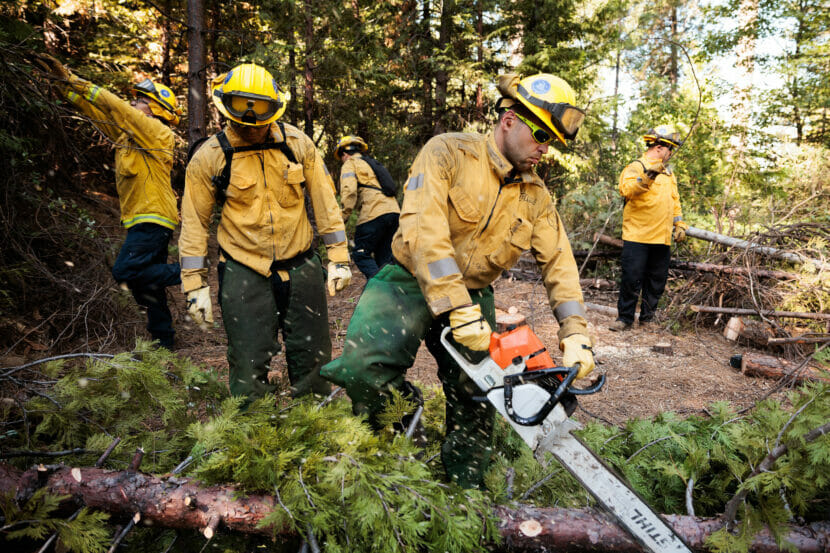
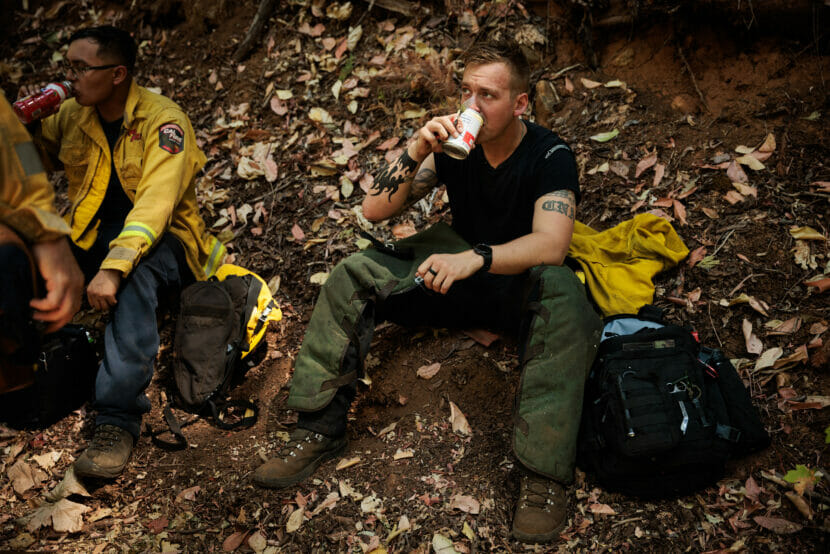
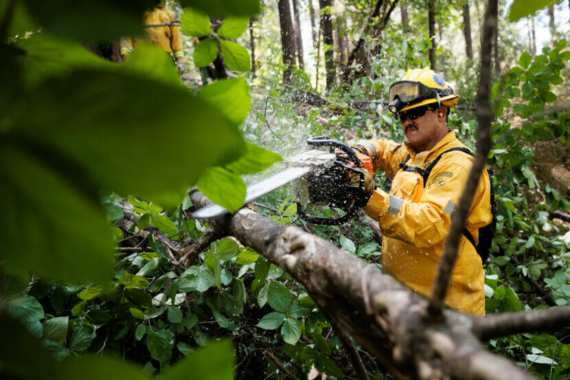
Members of the California National Guard’s Task Force Rattlesnake clear brush and small trees to reduce the likelihood of a high-intensity wildfire. (Max Whittaker for NPR)
NEVADA CITY, Calif. — Jaleel Brown had only been on the job a few weeks, chainsawing for California’s Task Force Rattlesnake, when he raised his hand to fight the Jones Bar Road fire.
“I didn’t know I was getting myself into. And that’s probably the craziest fire we’ve ever had here. And I had to ask the captain like, ‘Hey, this is how every fire is?’ ” he says.
A Guardsman for almost a decade, Brown had been considering leaving the military when he learned of the Task Force — and a different kind of soldiering.
That wildfire burned 705 acres west of Nevada City, Calif., in August of 2020, one of 8,648 fires in the state that year. What made it crazy for Brown was the terrain.
“We had to hike into the fire. We ended up at the bottom of the [river] drainage. We had to cut uphill and uphill — it went like forever cutting uphill,” Brown said, looking exhausted just from the memory.
Endless fire season
Recent images from Maui have shocked Americans with the worst death toll from a wildfire in over a century. But they’re familiar to communities of Western states, where a warming climate has made fire an existential threat. After California lost over 4 million acres to fire in 2020, the state funded Task Force Rattlesnake, to assist the California Department of Forestry and Fire Protection (Cal Fire).
“Fire season is almost a thing of the past. It’s year round,” says Carl Trujillo, a Sgt. 1st Class in the California Army National Guard.
“Even if there’s not fire, it’s prepping for fire and it’s treating the landscape to try and mitigate the impact that the fire has when it does come because it is going to come,” he says.
Cal Fire used to rely on prison inmates for firelines, which involved a lot more supervision. With the Task Force Rattlesnake guardsmen, it’s a military operation, with a practiced chain of command. After setting up the program as an emergency response in 2019, it’s now grown to 14 crews of National Guardsman who are salaried year round.
Members of the California National Guard’s Task Force Rattlesnake gather in Nevada City, Calif., to begin their day. (Max Whittaker for NPR)Members of the National Guard’s Task Force Rattlesnake clear brush and small trees to create a fireline, to deprive any fast-moving fire of fuel. (Max Whittaker for NPR)
“In the past, [Cal Fire] could depend on the National Guard to step up when they were called on and help fill any gaps. But as climate change has taken hold and changed fire behavior, there’s been a need to lean forward more proactively, and that’s a big role that Task Force Rattlesnake plays,” says Trujillo.
With the strain of COVID emergencies, civil unrest around the country, and the Guard’s regular overseas duties, the creation — and funding — of the task force has actually helped provide a degree of structure and reliability.
Nonetheless, climate change disasters are straining Guard troops nationwide, not just in California.
California National Guard Sgt. Jaleel Brown tosses a small tree aside as Task Force Rattlesnake work on fire prevention. (Max Whittaker for NPR)California National Guard Sgt. Tyler Bingham pauses for lunch while brush clearing with Task Force Rattlesnake. (Max Whittaker for NPR)
“In 2021, the National Guard spent 172,000 personnel days fighting fires, and that’s compared to about 18,000 personnel days in 2019. So it’s gone up significantly,” says Erin Sikorsky with the Center for Climate and Security. She tracks how climate is engaging military forces worldwide, including the U.S. Army National Guard. The strain on the Guard makes her wonder what would happen if the U.S. were at war.
“Many of those same troops are the ones that would be called upon in case of a conflict,” she says. “There would be a challenge there if they were being deployed at the levels they have been in recent years domestically and needed on the front lines.”
Fighting fires before they happen
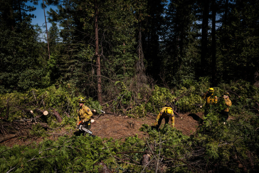
In California it’s been a mercifully quiet year so far, which means more days for Task Force Rattlesnake to work on prevention.
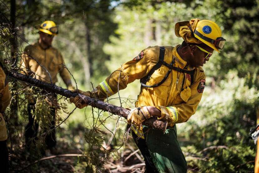
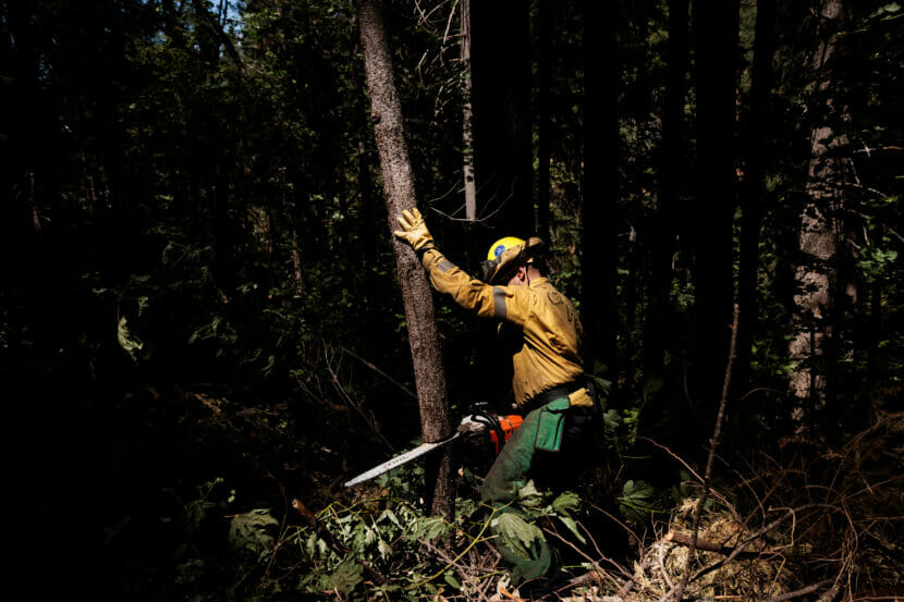
Just outside Nevada City, a crew walks up an abandoned logging road that smells of red cedar and damp earth. They’ve been reopening the road for weeks, for access and also as a potential fire-break to protect the houses further up the hill. With chainsaws axes and chippers they remove deadwood that could fuel a fire, and cut down “ladder trees” the short 10 or 20 footers, that could help a fire climb up to the giant cedars and ponderosa pines that seem to touch the sky.
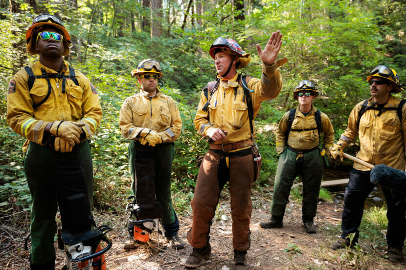
California National Guard Specialist John McMahan working on fire prevention as part of Task Force Rattlesnake. (Max Whittaker for NPR)Cal Fire Captain Eric Ayers briefs members of the California National Guard’s Task Force Rattlesnake before they spend the day clearing brush and small trees, all part of fire prevention tactics. (Max Whittaker for NPR)
Capt. Eric Ayers has worked 34 years with Cal Fire, and he’s supervising the Task Force on this summer’s day.
“If we were to have fire in here today, without this fuel reduction being done, the fire would be too intense, and it’s going to ladder up these trees and all the timber in here is going to be fully consumed,” he says.
Ayers is a third generation woodsman. His grandfather logged these woods. Centuries before that, Native Americans did controlled burns to keep the forest healthy. But now after decades without either, and with houses built further and further into the woods, Ayers says the job is urgent — and endless — across California.
“It’s kind of like painting the Golden Gate Bridge. You do the initial paint, you get to one end and you gotta go back and redo it,” he says.
But it’s work these guardsmen say they enjoy. Brett Carl joined Task Force Rattlesnake in 2020, after two years of doing COVID response for the National Guard. Sawing trees and lugging brush until he’s dog tired is more what he had in mind when he joined.
“It’s manly right? Can’t get more manly than that!” he says with a laugh. “I feel better about myself mentally, physically every day once we get out here running the chainsaw.”
Carl says the Task Force is an attractive transition from the military as well, setting up a possible career in fire fighting, which appears to be a growth industry as North America keeps posting record high temperatures.
California National Guard Specialist Brett Carl cuts down a small tree while working on fire prevention with Task Force Rattlesnake. (Max Whittaker for NPR)
Copyright 2023 NPR. To see more, visit https://www.npr.org.
Slow developing blueberries in a Douglas Island yard in early July 2021. (Photo by Matt Miller/KTOO)
Lisa Sadleir-Hart has filled her freezer with berries from her backyard in Sitka for more than 25 years. But this year, that freezer will be emptier.
“The crop looks terrible,” Sadleir-Hart said. “I hardly have any on my bushes.”
She said her bushes developed differently as spring turned to summer.
“I noticed that leafing out of the salmonberries seemed to take longer. It happened later,” Sadleir-Hart said. “And then boy, we sure didn’t have the number of flowers and buds that we did last year.”
Scientists and harvesters alike believe that berries have declined in Southeast Alaska in recent years, as human-caused climate change has reshaped the environment. A new project at the Sitka Sound Science Center will closely monitor berry plants throughout the seasons, to help both recreational and subsistence harvesters plan for the future.
In Southeast Alaska, and across the state, climate change is bringing more rainfall, less winter snowfall and hotter temperatures. According to the project’s lead researcher Alex McCarrel, those changes disrupt berry development because a berry plant’s life cycle is precisely tuned to its environment.
Each stage of development corresponds with the way the weather unfolds throughout the seasons.
“When the leaves are budding out, or when the flowers are going to be blooming,” McCarrel said. “When can we expect the berries to ripen? Or when is that best week you want to be picking berries.”
The study of those seasonal life stages is known as phenology. And it’s the foundation of some of the most important interactions in nature.
For example, a flower will typically bloom when pollinators are awake and hungry. And a knowledgeable harvester will typically know what time of year a bush will be most full of berries.
“Timing is everything,” McCarrel said. “And that is changing.”
To track those changes, McCarrel and collaborators at the U.S. Forest Service have deployed 16 trail cameras that are pointed at berries all season long. The cameras take thousands of time lapse photographs that can capture the precise timing of each critical life stage.
Each camera is placed next to a monitoring device that records precipitation, humidity and soil temperatures across a variety of microclimates in Sitka. McCarrel can pair that climate data with the photographs at the end of each summer to see how changes in the environmental conditions shape berry development.
The project also engages harvesters. Throughout the summer, volunteers like Sadleir-Hart noted how many ripe berries they could pick in the five minute time period, returning to the same patch once a week. Those records give McCarrel a more concrete idea of when maximum berry yield occurred for each bush.
By recording that data year to year, McCarrel and her team can start to identify patterns and trends that link specific climate conditions to changes in berry availability and timing.
That data is especially valuable for protecting food security. Sadleir-Hart, an educator for the Sitka Local Food Network, said that many rural Alaskan households rely on wild berry harvests.
“You know what berries cost in the grocery store,” she said. “They are not going to be able to replace that.”
But without data, it’s challenging to develop concrete adaptation and mitigation strategies. McCarrel said that the results of this research could help to solve that. Her hope is that the data could be used to inform new harvesting strategies.
“They can make decisions like, ‘I guess I’ll have to go out one week earlier than I did 10 years ago,’” McCarrel said. “Or I might need to look for better berries, higher up. Another 500 feet of elevation, because my spot is getting too hot.”
And if berry harvesters know how to change, it could help keep their freezers full.
It was scorching hot across much of the planet this summer. Asia, Africa, and South America had their hottest July’s ever. Temperatures in Beijing and other parts of northern China hovered around 100 degrees Fahrenheit for weeks, with some cities topping 120 F on the worst days. (Kevin Frayer/Getty Images)
And it wasn’t even close: the month was a whopping 0.4 °F warmer than the previous record set in 2019, and well over 2.1 °F hotter than the 20th century average.
“Most records are set in terms of global temperature by a few hundredths of a degree,” says Russell Vose, a climate expert at NOAA’s National Centers for Environmental Information. But this one, nearly half a degree Fahrenheit, was “bigger than any other jump we’ve seen.”
That was not what Vose expected to see. “I am rarely surprised, that’s what my friends tell me. And I was surprised by this number.”
The intensity of July’s heat is certainly exceptional, says Sarah Kapnick, chief scientist and climate expert at NOAA who worked on the report. It’s also part of a long, clear pattern of planetary warming going back decades, driven primarily by humans burning fossil fuels. It’s only likely to get hotter. “The next few years will be the coolest of my life if the world continues to emit greenhouse gasses,” Kapnick says.
July’s record-breaking temperatures were not subtle. Intense heat waves gripped many regions of the world. In the U.S, Arizona, New Mexico, and Florida posted their hottest months ever since NOAA started taking records in 1880. Northwestern China experienced some of the hottest temperatures ever, topping 122°F. Unseasonably hot weather also settled in across the Southern Hemisphere; even in the depths of winter, temperatures exceeded 100°F in some parts of Chile and Argentina.
The oceans ran an equally high fever. Off the coast of Florida, temperatures at the sea surfacetopped 100°F. Alarmed scientists rushed to protect or move coral nurseries to deeper, cooler water. Some parts of the North Atlantic Ocean hovered 7 to 10°F above the long-term average. The central Atlantic, the birthing ground for hurricanes, also experienced off-the-charts heat, raising the risk of more intense storms this season.
“Oceans also are key factors for regulation of climate by soaking up heat,” says Rajiv Chowdhury, a global health and climate expert at Florida International University, but “these useful impacts on land temperature become far less impactful when the oceans heat.”
Many scientists were alarmed not only by the intensity of the heat but also how long it lasted. “That’s what kills, the duration of heat,” not just the heat itself, says Pope Moseley, an intensive care physician and heat expert at Arizona State University. When heat persists—especially if nights stay exceptionally warm as they did in many heat-stricken zones last month—people’s bodies don’t get a chance to cool down.
Phoenix strung together 31 days of daytime temperatures that exceeded 110° F. The heat index, which takes both air temperature and the dangerous effects of humidity into account, topped 100° F for 46 days in Miami.
This year is shaping up to be one of the hottest years—and possibly the hottest ever—in recorded history. Next year could be even worse, says Gavin Schmidt, a climate scientist at NASA. An El Nino event, which raises planetary temperatures, is intensifying right now. “Not only is 2023 going to be an exceptionally warm and possibly a record year, but we anticipate that 2024 will be warmer still,” he says.
Any one super-hot month, or even year, solidifies a clear pattern: a steady upward march of global temperatures over decades. The last nine years have been the hottest ever seen. Each of the last five decades has been hotter than the one before.
“A year like this gives us a glimpse at how rising temperatures and heavier rains can impact society and stress critical resources,” says Kapnick. “These years will be cool by comparison by the middle of the century if we continue to warm our planet as greenhouse emissions continue.”
There are glimmers of progress. Global demand for fossil fuels could be nearing its peak, according to a 2022 analysis from the International Energy Agency, while countries from the U.S. to China are adding renewable energy sources, like solar and wind, at an unprecedented clip.
Copyright 2023 NPR. To see more, visit https://www.npr.org.
Suicide Basin, the birthplace of Juneau’s annual glacial outburst floods, sits about two miles above the terminus of Mendenhall Glacier. On Aug. 5, 2023, nearly 13 billions gallons of water drained from the basin, triggering the most destructive glacial outburst flood in Juneau’s history (Anna Canny/KTOO)
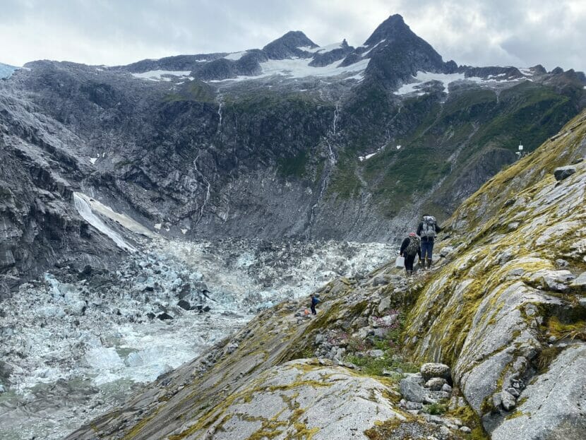
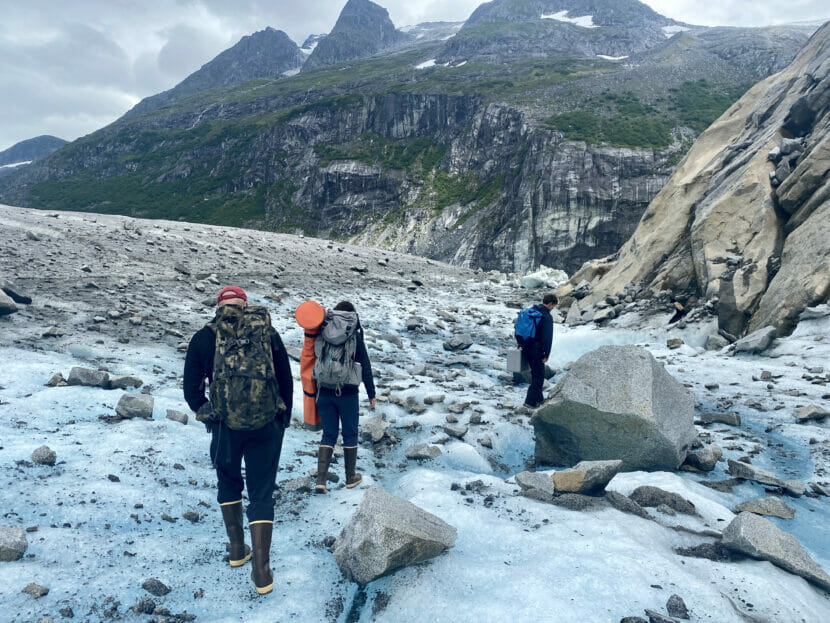
Three scientists shuffled across the vivid blue ice of the Mendenhall Glacier, following a silty channel carved between a steep mountain slope and the glacier’s edge. They wove around dripping, house-sized blocks of ice, heading toward a trail near the mouth of the channel.
An icy chute ten feet deep sits slightly downhill, at a precipice high above the glacier’s terminus. Three days earlier, a torrent of water had carved the chute after forcing its way through the ice dam that holds water in Suicide Basin — the source of the flood and the place where the scientists were going.
The scientists began a steep ascent up the face of the mountain, scrambling over loose boulders to the lip of Suicide Basin. Moving away from the blue expanse of the glacier, they stood at the edge of a deep, bowl-shaped valley, dwarfed by three steep peaks surrounding it.
Before the flood, this valley had been filled to the brim with 13 billion gallons of water. Now it was empty.
Eran Hood, Ed Neal and Abby Watts follow the icy path up a channel where waters from Suicide Basin coursed through on their way to Mendenhall Lake (Anna Canny/KTOO)
The team’s leader, University of Alaska Southeast hydrologist Eran Hood, peered down at the jumble of ice lining the bottom.
“This is crazy. I’ve never seen it collapse down so far,” Hood said. “I think something has fundamentally changed.”
There were just a few gray-green pools of meltwater at the bottom. But dark high-water marks stained the rock face more than 100 feet up, evidence of the water that had accumulated here for months before emptying suddenly.
The basin drains like this every year. The glacier, which blocks its mouth, acts as a dam. Throughout the spring and summer, the basin fills with rain and meltwater until the water builds enough pressure to crack through the ice. Then it works its way through those cracks and out under the glacier, triggering the start of a glacial outburst flood.
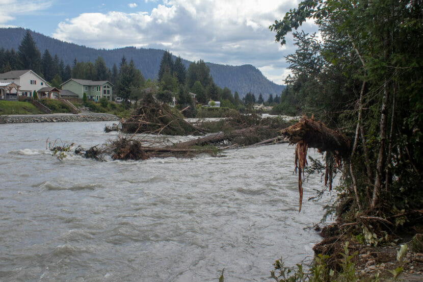
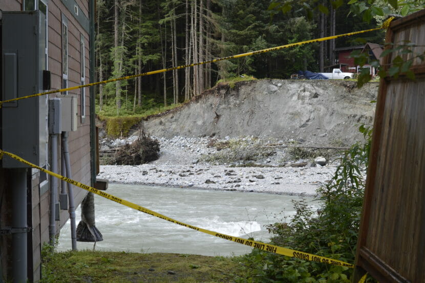
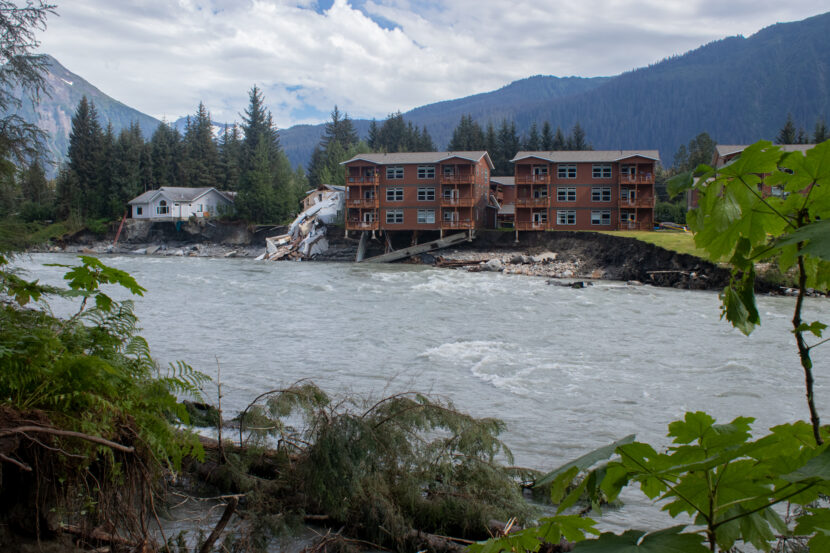
Most years, the flooding has been minor. But this year, it tore through the Mendenhall Valley with more force than ever before, gnawing through the riverbank and undermining homes that once seemed safe. Two homes were swept away completely, and dozens of people have been displaced.
For decades to come, the neighborhoods downstream in Juneau will be at the mercy of the ever-changing basin. Hood and his team went up to learn more about how, precisely, the basin is changing — and about what those changes might mean for future floods in Juneau.
A new lake
The floods started in 2011. But Hood, who has been studying the glacier for more than two decades, remembers a time before that.
“The entire basin was once filled with the glacier,” Hood said. “So there was no room for water.”
Then, about a decade ago, a piece of the glacier broke off and rapidly receded up the hill, exposing the basin. The remnants of that retreat are still visible at the basin’s head, where a last, large chunk of ice still perches on the cliff. That chunk is now known as Suicide Glacier.
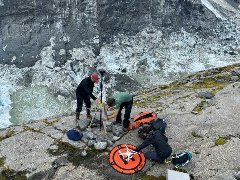
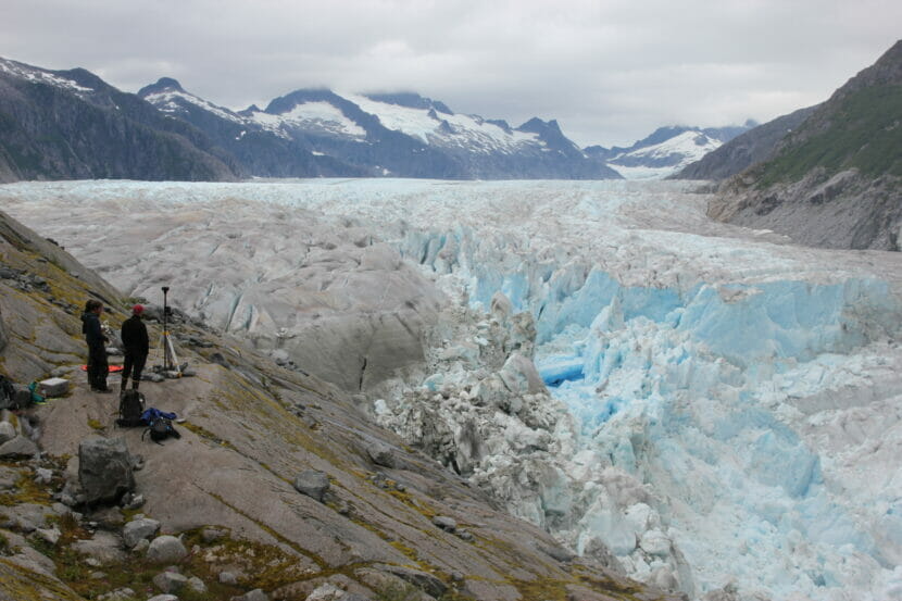
At the basin’s edge, Hood and research assistant Abby Watts assembled a tall, black tripod and laid out a miniature helipad, for a drone. The drone took off with a whir and flew to the far side of the basin.
By doing repeated drone flights, researchers can build a 3D model to estimate the volume of water held in Suicide Basin. The basin is almost entirely empty after the flood on Saturday, August 5th, 2023 with just a few remaining pools of meltwater at the bottom (Anna Canny/KTOO)
For about three hours, the drone flew back and forth across the basin, taking thousands of overlapping photos to capture every crack and crevice on the surface of the basin. Using a process called photogrammetry, Hood’s team can use the photos to build a three-dimensional map of the basin.
Understanding the basin’s shape matters because that determines how much water it can hold — and that partly determines how badly the river can flood. The National Weather Service builds its glacial outburst flood forecasts based on the volume of the basin.
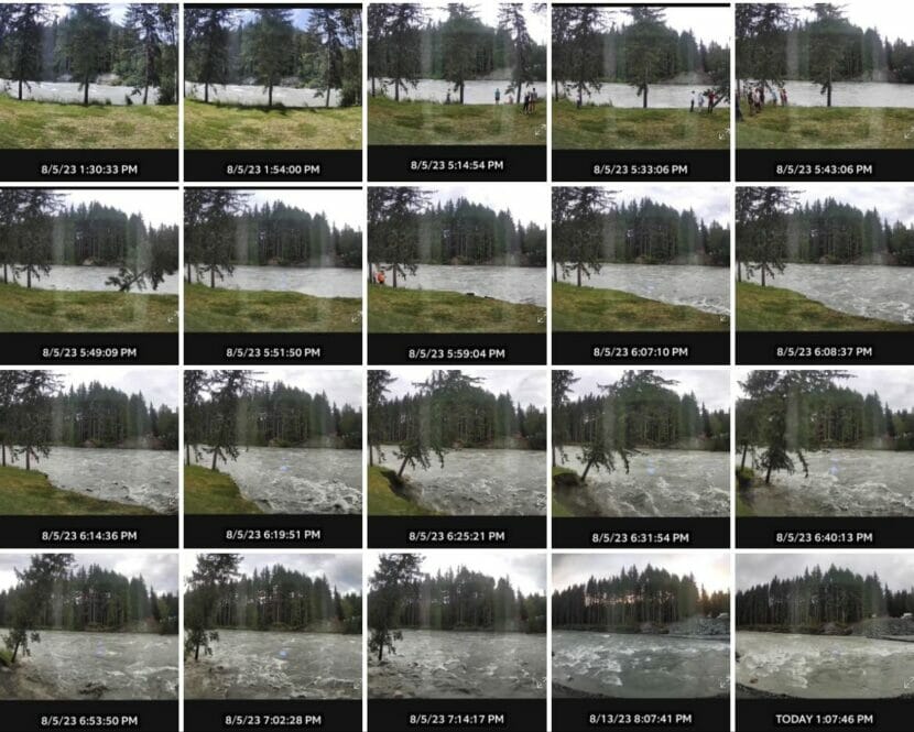
This year, those forecasts were off. The initial flood warning from the Weather Service predicted a peak flood stage of over 10 feet by Sunday morning, which would cause only minor flooding. The actual peak was nearly 15 feet — three feet higher than the river had ever flooded before.
An unsolvable problem
Figuring out the size and shape of the basin is complicated, because it’s changing all the time — one of its sides is made out of ice. Scientists believe the basin is growing. They estimate that the amount of water it can store has increased by about 15% over the last five years. But they’re not sure exactly how it’s growing.
There are a few different factors that might come into play. On one end of the basin, the vivid blue on the glacier’s face indicates frequent calving. Large chunks of ice break off onto the bottom of the basin, adding to the existing jumble of icebergs left behind by the Suicide Glacier’s retreat.
Scientists believe the ice has been melting faster and faster in recent years.
“The more all of this ice sitting in here can melt, the bigger this flood can be” Hood said.
At the same time, the calving from the glacier’s face may have allowed the basin to get wider, therefore holding more water. That means there’s both more meltwater and more space to store that water. That’s one theory about why this year’s flood was so much bigger.
“But then, the dam is decreasing in height because the glacier is melting away,” Hood said. “So we’ve got these two competing factors.”
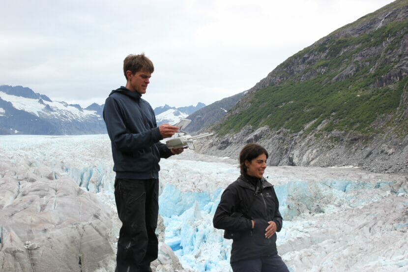
Eran Hood holds a drone remote, with the Mendenhall Glacier in the background. The drone survey will help Hood and his team determine how changes in the glacial ice shapes flood potential in Juneau (Anna Canny/KTOO)
So it’s hard to nail down how much water the basin can hold — and that’s still just one variable that determines how bad flooding can be. The trickier part is understanding how that water drains from the basin.
Hydrologist Ed Neal of Alaska Hydroscience sat watching the drone from a boulder, facing the roughed-up surface of the glacier.
Beneath that ice, he said, water is always flowing. Even if the basin’s volume stayed constant, the way the water gets out could change — and that’s just as important for knowing how bad a flood will be.
“Say you got X amount of water. If you let it out of a garden hose, it’s gonna take a long time to drain,” Neal said. “If you let it out of a firehose, it’d take a short time to drain it.”
Usually, the dam at Suicide Basin releases more gradually. As water pressure builds up in the basin, it creates small cracks in the ice that let the water leak out slowly under the glacier. Over time, the water melts those channels larger and larger, increasing the flow.
But there are also many existing stream channels, deep under the glacier, that feed into the Mendenhall River all year long. If the water draining from the basin were to tap into one of those, it could release much, much faster.
Blocks of ice left behind by last weekend’s glacial lake outburst flood in Juneau, Alaska. Flood waters coursed through this channel before raising water levels downstream in Mendenhall River (Anna Canny/KTOO)
One theory about the ferocity of this year’s flood is that the calving at the glacier’s face might have exposed those existing channels to the basin’s water. But pinpointing the drainage channel is nearly impossible.
“Somewhere in there, under that jumble of icebergs, is where the water released,” Hood said. “We’d love to study that. But it’s not accessible.”
This leaves scientists with what is, for now, an unsolvable equation. With the drone survey, they can only find one variable. Which means that predicting Juneau’s outburst floods will remain a bit of a crapshoot.
Worse to come
Glacial outburst floods are not exclusive to the Mendenhall Glacier — Andean and Himalayan communities have seen outburst floods that killed thousands of people. One recent study estimated that 15 million people globally are threatened by them.
Human-caused climate change is largely to blame. Retreating glaciers around the world have created unstable lakes that are dammed by ice or sediment. When those dams fail, they can send huge walls of water crashing down populated valleys.
So far, warming temperatures have not made the floods more frequent. But they have accelerated glacial melt, which is creating new glacial lakes and making existing lakes bigger. That means when glacial dams fail, the potential for devastation is greater.
The Mendenhall Glacier dams water in Suicide Basin. As the glacier calves, it could be creating more storage space for water. That could cause bigger glacial outburst floods in the future (Anna Canny/KTOO)
The Mendenhall Glacier has been receding for centuries, but warming temperatures fueled by human pollution have made it thin and retreat much more quickly.
“If the glacier hadn’t receded, there would be no outburst flood,” Hood said.
While the larger phenomenon of glacial outburst floods is driven by climate change, Hood said this year’s hot summer didn’t contribute much to the severity of this year’s flooding — and big storms don’t add much water to the basin, either.
But Juneau’s glacial outburst flooding could be made worse by other climate-driven changes. Extreme rainfall is becoming more frequent across Southeast Alaska. If a glacial outburst flood were to coincide with a drenching rainstorm — if the river were already swollen with water when the basin emptied — that could be bad.
“Now, you might have a 50-year flood happening every year, or every other year,” Neal said. “If you stack that on a big rainfall peak, you’re gonna start having some serious energy.”
And that’s not far-fetched. This time last year, Juneau was drenched by an atmospheric river.
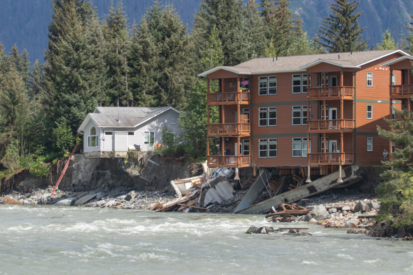
A house and condo buildings in the 4400 block of Riverside Drive hang precariously over the Mendenhall River after their foundations were eroded away during record high water from a glacial outburst flood on Saturday August 5th, 2023. (Mikko Wilson/KTOO)
Meanwhile, many of the homes along the river were built on soft, loose sediments that erode easily. In this year’s flood, it was rapid erosion rather than inundation that caused the worst damage.
And Hood says the threat posed by glacial outburst floods will hang over Juneau until the Mendenhall Glacier melts down to the point where it can no longer dam the basin. That will likely take decades — and Hood would be surprised if Juneau doesn’t see even worse floods before it happens.
“It’s unlikely that we would have experienced the largest flood within the first 10 years or so,” Hood said.
So the hundreds of residents who live along the bank of the Mendenhall River can’t know what’s coming from year to year — but they should expect something worse than what happened last weekend, eventually.
The results from Hood’s drone survey aren’t in yet, but he says one thing is for sure. High above Juneau, the basin keeps growing.
Close
Update notification options
Subscribe to notifications
Subscribe
Get notifications about news related to the topics you care about. You can unsubscribe anytime.


9(MDEwMjQ0ODM1MDEzNDk4MTEzNjU3NTRhYg004))
9(MDEwMjQ0ODM1MDEzNDk4MTEzNjU3NTRhYg004))