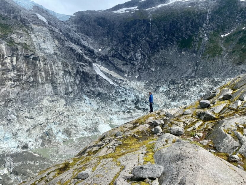
Researcher Eran Hood stands on the lip of an empty Suicide Basin just a few days after it drained to create a record-breaking glacial outburst flood in August 2023. (Photo by Anna Canny/KTOO)
The National Science Foundation has awarded a team of researchers that includes Juneau scientists $990,437 to study glacial outburst flooding from Juneau’s Mendenhall Glacier.
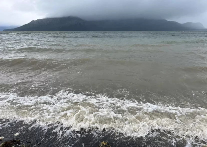
A glacial outburst flood is caused when a glacial lake releases its water into a river. For the last two years in a row, such flooding has caused significant damage to homes in Juneau. The lake, called Suicide Basin, formed on the side of Mendenhall Glacier.
University of Alaska Southeast Geophysics Professor Jason Amundson said the research will focus on the basin, glacier and the flow of water into Mendenhall Lake. But he thinks the information they gather will help hydrologists understand the timing and flow of water down the Mendenhall River and into surrounding neighborhoods.
“There’s so much variability from one year to the next, and part of that is that it’s so hard to just observe the basin,” he said.
Studying the shape of the basin and how it changes could give them a better sense of how much water could be released each year, and potentially how quickly.
He said this work is going to take some time, so it may not help those who want to know what this year’s glacial outburst flood will look like.
Environmental Science Professor Eran Hood is the other UAS researcher on the team. He and Amundson have been studying the formation of Suicide Basin and its outburst flooding for years.
“Basically we have not had a lot of funding to work on the Mendenhall outburst flood, largely because, for a decade or so, it was never big enough that it created a serious hazard,” Hood said. “So there was no real sense of urgency in terms of people funding research on it.”
But now that the flood is causing extensive property damage in Juneau, he said it’s urgent that a larger team is committed to understanding it.
And that research could influence the formation of local policy.
“There are a lot of ideas being tossed around in terms of building levees or building walls along the river,” Hood said. “Well, any of those engineering solutions to mitigate the flood hazard will be helped by or informed by any numbers that we can come up with in terms of the potential future flood volumes.”
Hood said that even with the information they have now, it will be easier to predict if other communities near glaciers may see this type of flooding in the future.
“If we go back in time 30 years — now, and we have the same capacity to model then that we do now, we could have looked at the Suicide Basin there and said, ‘Hey, this is a place where a nice marginal lake is likely to form that could lead to outburst floods.’ Nobody did that,” Hood said. “And so we had no warning of it.”
The five-year grant will allow researchers to understand Suicide Basin’s formation more deeply, how its evolution will impact future glacial outburst events, and what indicators could forecast glacial outburst flooding in other communities.
Researchers from the University of Alaska Fairbanks and Carnegie Mellon University will join the two UAS professors on this project, and the team plans to take on graduate and undergraduate students.
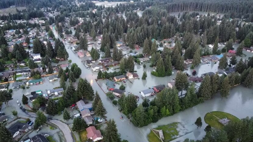
Water fills the streets and floods houses in the Mendenhall Valley early the morning of Tuesday, August 6, 2024. (Photo courtesy of Rich Ross)
Human-fueled climate change is making natural disasters like floods and landslides in Alaska more common and destructive. While property owners can purchase federal flood insurance, they might be out of luck if a landslide inundates their home.
One Southeast Alaska lawmaker has a proposal to offer a state flood insurance alternative that may include coverage for both floods and some landslides.
State Sen. Bert Stedman, R-Sitka, said the state needs to offer its own flood insurance alternative because the federal government’s current policies are inadequate and expensive for many Alaskans.
“They’re getting ripped off by the federal government on flood insurance. They’re getting that economic shotgun held to their head on how they can rebuild their properties that’s frankly unfair,” Stedman said.
He proposed a bill that would create an Alaska Flood Authority to manage a state flood insurance fund. His aim is to provide more coverage at a lower cost to homeowners as human-fueled climate change makes disasters like these a more frequent reality in Alaska.
Stedman is a Republican who represents communities like Sitka and Wrangell, which have experienced destructive or deadly landslides in recent years. The bill’s language includes “mudflow” as a type of flooding, which means certain landslides could potentially fall under the proposed state coverage.
His proposal comes after two large flood disasters last year in different parts of the state. Juneau experienced record-breaking flooding from the annual Suicide Basin glacial outburst and lower Kuskokwim River communities faced historic breakup flooding that inundated homes and community services.
Stedman said the Alaska-specific flood insurance policy would be a cheaper alternative to the federal program because it would be tailored to insure just the state’s floods, not the nation’s.
“There’s a lot of problems with the federal flood insurance program,” he said. “The first order of the day is to get the subject matter in front of the legislators and start educating them so they understand the premium ripoff that our citizens have been paying for decades.”
Most standard homeowner insurance policies do not cover flood damage. Flood coverage is typically a separate addition. Pretty much the only place you’ll be able to find that type of coverage is through the NFIP, or the National Flood Insurance Program. The federal government offers its own flood coverage because private insurers have historically shied away from it.
In some coastal communities in Alaska, homeowners are required to have the additional flood coverage. Stedman said that can get really expensive.
“The concern that we have is, especially along the coast, we’re pushed into this federal flood insurance program, but the rates that they charge are excessive,” he said.
The bill’s language says the authority wouldn’t be allowed to charge a rate that is “excessive, inadequate, or unfairly discriminatory” and the rates would be determined based on historical flood and damage data. There’s no fiscal note on the bill yet, but Stedman estimated it will cost the state several million dollars in seed money.
Emil Mackey is an insurance agent in Juneau and knows his way around what policies are available for residents in Southeast. He’s excited about some aspects of the bill, but has doubts that the rates of a state program would actually be lower.
“What you have to understand is the National Flood Insurance Program is subsidized by the federal government,” he said. “If we create this, the only way to do that is to also subsidize the program. And I just don’t see the need.”
But what he does see the need for is landslide insurance. The mudslide language in Stedman’s bill is a start.
Getting landslide insurance in rainy and mountainous regions of Southeast Alaska is historically difficult. Mackey chalked it up to the growing frequency of destructive landslides in the region, and how that’s changing the way insurers view risk.
“Where the need is, is really for landslide insurance because we don’t have any insurers in the state that do landslides and I would like to see something like this,” he said.
Stedman said he hopes that landslides are a part of the discussion as the bill moves through the legislature, but they are not the main focus of the legislation.
The legislative session begins on Tuesday, Jan. 21.
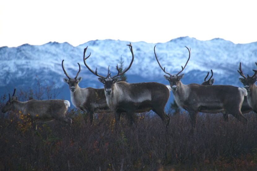
A group of Western Arctic Herd caribou pause in front of mountains in Kobuk Valley National Park during fall migration in 2016. The Western Arctic herd, one of the largest in the world, has been in decline for the past two decades. The 2023 census shows that the decline is continuing. The population is now only about a third of what it was in 2003. (Photo by Kyle Joly/National Park Service)
The Arctic tundra shifted this past year from capturing carbon to releasing it, which means it’s now contributing to rising global temperatures, according to the 2024 Arctic Report Card from the National Oceanic and Atmospheric Administration.
Rick Thoman, a climate researcher at University of Alaska Fairbanks, edited the report and said the NOAA report card also documents rapid declines in caribou herds.
“Particularly the large migratory herds, including the Western Arctic herd, have shown significant drops in population numbers, and they’re not recovering,” Thoman said. “Now it’s not all bad news. Some of the smaller coastal herds that don’t migrate as far have numbers [that] have rebounded in recent years from lows a decade or two ago.”
He said declining numbers are due to several factors connected to climate change. More precipitation in the winter can interfere with caribou feeding, and warmer summer temperatures mean bigger plants grow that crowd out the lichen that caribou eat.
Thoman said surface air temperatures are increasing across the Arctic, and precipitation is increasing, especially in winter, because even modest rising temperatures increase the amount of water the air can hold.
He also said the average extent of sea ice in the fall was the lowest on record, and that has led to increased ocean traffic.
“We had many, many transits of the Northwest Passage. And so the port of Nome [has been] very busy, as we’ve seen the last few years,” Thoman said. “A lot of traffic along the northern sea route.”
He said the uptick in vessel traffic means an elevated risk for a significant accident in Alaska coastal waters.
One big piece of good news from the report is that ice seals are still doing well, according to Thoman.
“Yes, we’ve had a decrease in sea ice, and we’ve had a couple of really low years there, 2018 and ‘19 in the Bering Sea.” Thoman said. “But overall, the health of ice seals is still pretty good. So I think that’s good news for Alaskans.”
The Arctic report card from NOAA incorporated research from October 2023 to September 2024. Next year will be the 20th year they’ve produced the report card consecutively.
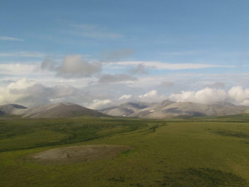
Green summer tundra and the rolling Mulgrave Hills in northwestern Alaska’s Cape Krusenstern National Monument are seen on July 11, 2011. The Mulgrave Hills are the farthest west extension of the Brooks Range. Arctic tundra, which for thousands of years was a net sink for atmospheric carbon, is now a net emitter, adding to the greenhouse gas load that is warming the earth, according to the 2024 Arctic Report Card released by the National Oceanic and Atmospheric Administration. (Photo provided by the National Park Service)
For millennia, the tundra regions of the Arctic drew in carbon from the atmosphere and locked it in permafrost.
That is the case no more, according to an annual report issued on Tuesday by the National Oceanic and Atmospheric Administration.
The tundra regions have become a net carbon source rather than a carbon sink, the result of permafrost warming, increased wildfires and other effects of climate change, said the 2024 Arctic Report Card, a NOAA project with nearly 100 collaborating scientists from different organizations in Alaska and elsewhere.
The sink-to-source switch means that carbon-based plant and animal matter that has been stored in permafrost for thousands of years now streams into the air because of warmth-induced decomposition, said Brendan Rogers, a scientist with the Woodwell Climate Research Center and one of the Arctic Report Card’s co-authors.
The fear is that the change will exacerbate the warming caused by carbon gases that envelop the planet and hold in warmth, creating what is called a greenhouse effect, Rogers said on Tuesday.
“There is a concern, of course, with the amount of carbon that’s stored, especially in permafrost. As climate warms, as those soils warm, that could be released. The scientific consensus is that some of that will be released. It could be the equivalent, for example, to a major greenhouse gas-emitting country,” Rogers said at a news conference, held by NOAA at the American Geophysical Union’s annual meeting in Washington, D.C.
The annual report card describes changes in a region of the world that has warmed up at nearly four times the global rate.
The tundra regions’ switchover from sink to source has occurred over at least the last two decades, according to the report card. While there have been some recent years when the tundra region functioned as a net carbon sink, on average it is a net carbon emitter, Rogers said at the news conference.
Permafrost, wildfires and the relationship between them have converted the tundra regions, according to the report.
In Alaska, average permafrost temperatures across an array of long-term monitoring stations were the second highest on record, the report card said. The temperatures were the highest ever recorded at about half of the Alaska sites, the report card said.
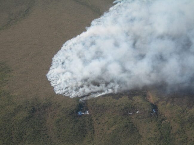
Smoke from the Noatak Grand Canyon Fire, burning in tundra in Alaska’s Noatak National Preserve, rises into the air on June 8, 2012. Wildfires, which are becoming more intense in Arctic regions, can expose permafrost and cause it to thaw. (Photo by Dan Stevenson/National Park Service)
Permafrost need not be thawed to emit carbon gases, Rogers said in an interview prior to the report’s release. As soil warms, even if temperatures remain below freezing, microbes become increasingly active and increase their expulsion of carbon dioxide, he said. Such carbon gas respiration is a byproduct when microbes break down organic matter.
Wildfire as a direct and indirect carbon emitter
Wildfires factor into the sink-to-source switchover because of their direct emissions and their effect on permafrost, the report card said.
Wildfires in circumpolar regions have emitted an average of 207 million metric tons of carbon annually since 2003, it said. Those fires are getting more intense, and this year’s fires north of the Arctic Circle emitted the second-highest amount of carbon yet recorded, the report card said.
Wildfires are normal in the boreal forest, which can regrow and absorb carbon from the air through photosynthesis, Rogers said at the news conference.
“What’s the challenge right now is, of course, in areas of permafrost, that those fires will remove the insulating soil organic matter. That permafrost can thaw and lead to longer-term emissions,” Rogers said. “And we’re just seeing this general intensification of wildfires since the mid-20th century, so that they’re emitting that carbon into the atmosphere.”
Concerns about fire unlocking permafrost carbon prompted a new policy in one area of Alaska, the Yukon Flats National Wildlife Refuge. Through consultation with the Woodwell Climate Research Center, a Massachusetts-based research organization, the refuge identified about 1.6 million permafrost-laden acres where fires, if they broke out, would draw responses to limit their burning. Past practice in those areas was to allow fires to burn naturally. The sites put into that classification were identified as holding a type of ice-rich permafrost called yedoma that is considered particularly vulnerable to thaw.
There was no fire suppression this year on any of those newly identified yedoma sites, but one fire that did draw a response burned over a separate area that does likely contain that type of ice-rich permafrost, said Jimmy Fox, the refuge’s superintendent. The Ed Berg Slough Fire flared up in June at a site that had not burned in recent years, and a quick response by firefighters limited it to about 4 acres.
The site would have qualified for the new classification had it not already been designated for what is considered a “modified” firefighting response, Fox said.
“Fortunately, although the fire did not start in a new yedoma protection area, researchers will likely be able to evaluate the event and what effect the suppression may have in protecting yedoma and at what cost,” Fox said by email.
Ted Schuur, a permafrost expert at Northern Arizona University and one of the report’s co-authors, emphasized the long-term nature of the switch.
“What we’re describing is a long-term, 20-year trend towards this increasing source from the tundra region,” he said at the news conference. That trend will be sustained even if there are occasional years when the tundra does soak up more atmospheric carbon than it emits, he said.
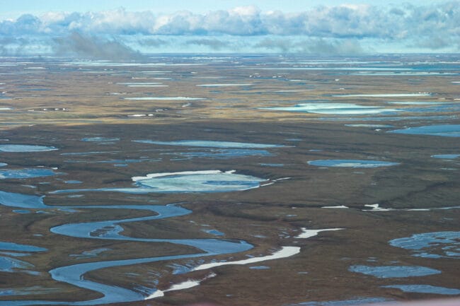
A few snow drifts remain on June 18, 2004, on the Arctic coastal plain of the National Petroleum Reserve in Alaska. The amount of atmospheric carbon absorbed by the Arctic’s tundra region in the summer is now outpaced by the amount of carbon dioxide emitted through permafrost warming and thaw, wildfires and winter carbon dioxide releases, according to the 2024 Arctic Report Card. (Photo by Craig McCaa/U.S. Bureau of Land Management)
Winter emissions, which occur when there is little or no sunlight to enable plant photosynthesis, are particularly high, said Schuur, who has documented the phenomenon in the Denali National Park area and elsewhere in Alaska.
This year’s emissions of carbon dioxide and methane, both of which are greenhouse gases, hit a new record, primarily because of wintertime, Schurr said. He noted that wintertime carbon emissions from tundra had not gotten much study in the past. “So in places that we’re hardly paying attention, we see records being set, and we think it’s very important,” he said.
Continued warming in the air and water
Beyond explaining how the tundra regions have shifted from being net carbon sinks to net carbon emitters, the report card described a continuing long-term trend toward a warmer and wetter Arctic.
Arctic annual surface air temperatures for the 12 months ending in September 2024 ranked second warmest since 1900. An August heatwave set new daily records in several sites in northern Alaska and Canada, the report card noted. The last nine years in the Arctic were the nine warmest on record, the report card said.
The past summer was also the wettest in the Arctic on record, it said. Despite above-average snow accumulation in the past year across the Arctic, the snow season was compressed in some places. In parts of Arctic Canada, the snow season was the shortest in 26 years, and overall, Arctic snowmelt is occurring one or two weeks earlier than it did historically, the report card said.
The sea ice minimum extent reached in September was the sixth lowest in the satellite record. All 18 lowest annual minimums have happened in the last 18 years.
Arctic greening, a satellite-based measurement of the northward expansion of woody shrubs and other plants as the environment warms, was the second highest on record, the report card said. The greening trend has been measured since 1990. Even though that new plant growth results in more intake of atmospheric carbon dioxide during the growing season, that amount of absorption is outweighed by the amount of carbon emitted from the ground and from the plants themselves during the dark non-growing season, the report card said.
There were regional variations and outliers.
One was the Chukchi Sea off northwestern Alaska. Most areas in the seas around the Arctic Ocean had August sea surface temperatures that were 2 degrees Celsius to 4 degrees Celsius, or 3.6 degrees to 7.2 degrees Fahrenheit, warmer than the 1991-2020 August average. However, the Chukchi was 1 degree to 4 degrees Celsius, roughly 1.82 degrees to 7.2 degrees Fahrenheit, cooler than that past average.
Melt on the Greenland Ice Sheet was a bit of an anomaly from the more long-term trend. This year’s loss of Greenland ice was the smallest since 2013, the result of more snowfall than usual, the report card said.
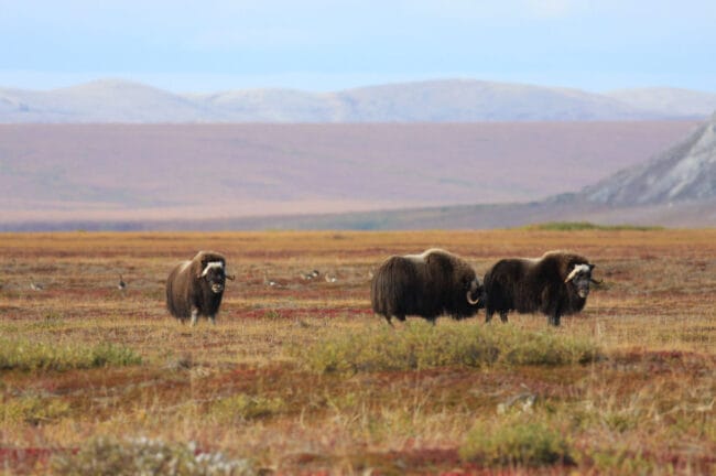
Muskox and geese roam vegetated beach ridges in front of the Igichuk Hills in Alaska’s Cape Krusenstern National Monument on Aug. 31, 2008. Tundra plants absorb atmospheric carbon in the summer, when they use sunlight to photosynthesize, but they emit carbon dioxide in the winter, when the daylight is gone. (Photo provided by the National Park Service)
Each year’s report card focuses on some specific Arctic species, and this year’s document described warming effects on tundra caribou and Alaska’s ice-dependent seals.
Uncertain future
NOAA has released the Arctic Report Card every year since 2006. Next year’s report is scheduled to be the 20th in the series. That means 2025 “will be a big event for the Arctic report card,” said Twila Moon, a lead editor of this year’s report and a scientist at the National Snow and Ice Data Center in Colorado.
That report is already in the works, she said at the news conference.
“The Arctic report card is a year-round effort, and we’ll be thinking about the next one as soon as we wrap up this one,” she said.
But the fate of the annual report card and NOAA itself are uncertain in the incoming Trump administration
NOAA, including its National Weather Service, is one of the federal agencies that may be slashed by the incoming administration. The conservative Heritage Foundation’s blueprint for remaking the federal government, called Project 2025, proposes deep cuts to NOAA and privatization of many of its functions, including those of the National Weather Service. There are fears among scientists that the incoming administration’s cost-cutting plan led by billionaire Elon Musk and former presidential candidate Vivek Ramaswamy will gut NOAA and its services.
President-elect Donald Trump has long opposed action to combat climate change, which in the past he called a hoax, and he has cast doubt on climate scientists’ reports.
NOAA Administrator Rick Spinrad, speaking at the news conference, expressed optimism nonetheless about the agency continuing its work to document climate change in the Arctic and elsewhere and to help people combat and adapt to it.
NOAA, he said, is a “mission agency” with science that responds to needs that continue to grow with intensifying events like wildfires, floods, drought and coastal inundation.
“In fact, the argument I would make is that now more than ever, the need, the requirement, the demand signal, if you will, is higher than ever before,” he said.
There can be changes to make the investments more efficient, but studies have shown that “the return on those investments is extraordinary, in many cases, 10-to-1 in terms of protection of lives and property,” he said.
“This report is now more than four years old; it’s still getting thousands of unique hits a month on the IARC website,” Thoman said. “And so that told us that this kind of report had enduring value to people in Alaska and beyond.”
IARC teamed up with the University of Alaska Fairbanks and Thoman’s employer, the Alaska Center for Climate Assessment and Policy.
More than 35 people were brought on to contribute to the project — double the number of the first version. Key contributors like IARC’s Brian Brettschneider returned to the project while several new names entered the mix.
The cover, an aerial shot of a 2023 landslide in Wrangell that killed six people, sets a poignant tone for the report. As the name suggests, Alaska’s environment is changing — and its creating new challenges for Alaskans. Thoman said the wording of the title was intentional.
“We specifically did not want ‘Alaska’s Changing Climate’, because the impacts of that changing climate are what people really feel,” Thoman said. “Those are the kinds of things that impact people, and they impact our land and our resources right down to what’s for dinner tonight.”
To help a wide audience understand those changes, sections like winter precipitation begin with the broad statement, “most of Alaska is seeing more mid-winter snow.” Typically, such statements are followed up with a very simple explanation like, “This increase is driven by warmer temperatures that enable air to hold more water vapor.”
Thoman said he worked in tandem with ACCAP’s science communications lead, Heather McFarland, to break things down to the simplest terms.
“Heather will go through and say, ‘That’s jargon, I don’t understand this,’ ‘Oh, that’s good,’” Thoman said. “Heather will do that with text from other experts as well, to get that into the style that you see there.”
A page in Alaska’s Changing Environment 2.0 featuring observations made by Bobby Schaeffer in Kotzebue. (From IARC)
While not new, Indigenous voices are now sprinkled throughout the report. The insights provide anecdotal evidence of the changing environment, like a story shared by Seldovia’s Stephen Payton.
“Elders also say to wait to pick until after first frost, but now the berries are ripe before that point,” Payton shared at an Alaska Berry Futures listening session.
These changes are prompting questions about how Alaskans should respond, both at the local and legislative levels.
“We certainly hope and expect that this information will help to inform some of those discussions, because we’re providing this information in a non-technical way that anybody that’s interested can get to,” Thoman said.
Printed copies of “Alaska’s Changing Environment 2.0” are headed to the American Geophysical Union’s annual meeting in Washington D.C next week. Digital and web versions are available at IARC’s website.
Storm front coming in to Wrangell on August 25, 2024. (Colette Czarnecki/KSTK)
During a phone call on Thursday, U.S. Senator Lisa Murkowski said that Wrangell’s been on her mind one year since the deadly landslide. She said the disaster is something people can’t easily shake if they’ve seen it.
“This summer, when I was there visiting my folks, we went out on the boat and saw it from a further distance and different perspective,” the Republican lawmaker said. “It’s just this very physical reminder of a scar and a wound.”
Coincidentally, Murkowski said she spoke with the Senate Appropriations Committee about disasters and proposed legislation that fiscally supports updated monitoring systems for all natural disasters on Nov. 20, the one year anniversary of the landslide that killed six people.
“To talk about just some of the disasters that we’ve seen in Alaska in this past year – Wrangell and Ketchikan with the landslides, but previously the deadly slides in Haines and Sitka, and the floods up north,” she said.
The talk was mostly about the need for better weather forecasting through additional sensors. She said she’s been working on a bill with Democratic Sen. Alex Padilla from California for several months.
If passed, the Improving Atmospheric River Forecasts Act would direct the National Oceanic and Atmospheric Administration to create an accurate forecast system to better predict the timing and predictability of atmospheric river storms. Atmospheric rivers are known as “rivers in the sky” and can vary in size and shape. They can cause excessive rain, floods and landslides, like in Wrangell last year. State geologists found excessive rain in a short time was a major contributor to that event.
“Because we just introduced it right at the end of this year, it’s at the point where we’re not having hearings on new bills,” Murkowski said. “What we wanted to do was get it out there in the public for consideration.”
She said they’ll reintroduce it when the new Congress convenes in January.
This support would also improve monitoring systems for other natural disasters throughout the nation, like a bill introduced earlier this year on earthquake hazards mitigation.
“So it’s drought, it’s floods, it’s hurricanes,” Murkowski said. “It is tornadoes, it’s landslides, it’s fires – fires are everywhere.”
She said the legislation is sparking conversation and feedback.
“As we work to advance this next year, we will be reaching out to communities that have been impacted that know and understand in real time, why this would be beneficial,” Murkowski said. “So it goes both ways. They can contact us, but we’ll also be reaching out to them.”
She said she’ll be able to talk about this with Wrangell’s Borough Manager Mason Villarma when he’s in Washington D.C. on Dec. 3.
Close
Update notification options
Subscribe to notifications
Subscribe
Get notifications about news related to the topics you care about. You can unsubscribe anytime.