Climate Change

Alaska glaciologists reflect on a rapidly changing icescape

Mendenhall Glacier on Friday, Feb. 21, 2025. (Photo by Clarise Larson/KTOO)

Listen to this story:

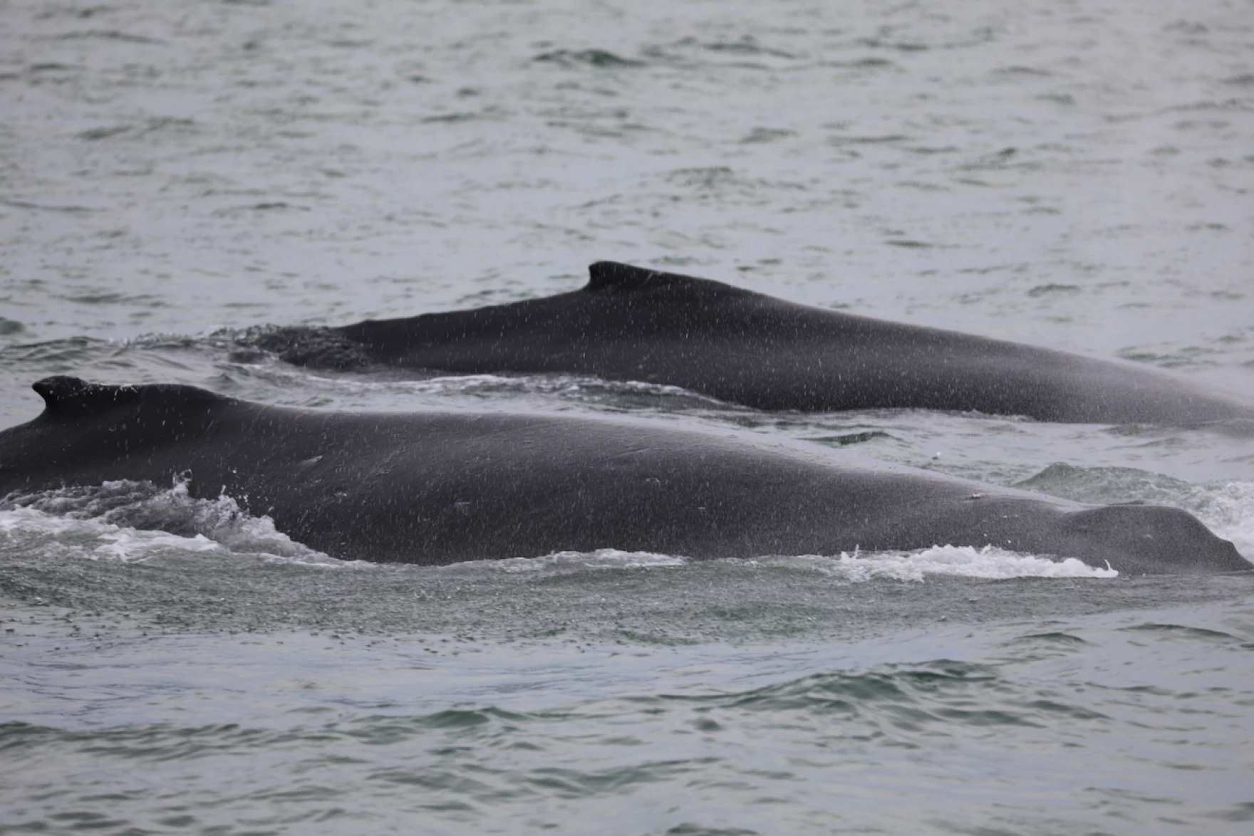
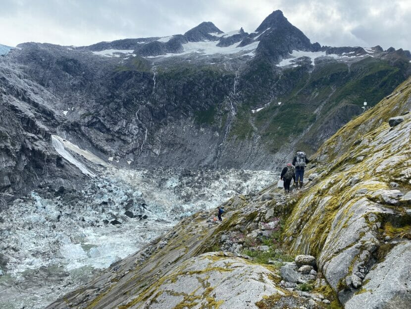
Glaciers shape the land and lives of Alaskans — carving mountains, funneling cold freshwater into rivers, carrying nutrients to the sea and reflecting sunlight back to space. 

Friday marked the first-ever World Day for Glaciers, a day observed by the United Nations to sound the alarm on the accelerating pace of global melting. Scientists who study Alaska glaciers spoke about their research to uncover how these rapidly changing systems affect our world. 

Kiya Riverman studies what makes glaciers flow as a glaciologist and associate director of the Juneau Icefield Research Program. 

“Often we have this sense that glaciers are this really static thing,” she said.  

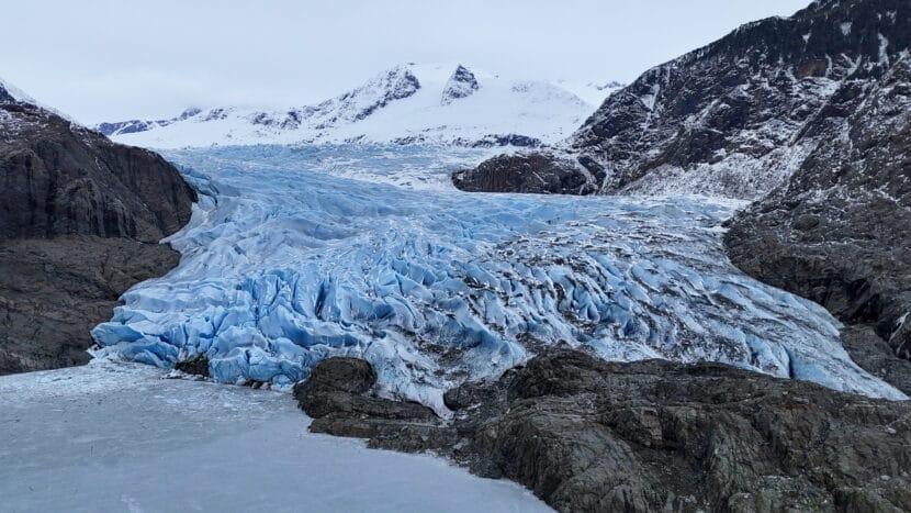
Before and after pictures show glaciers retreating, sure, but usually over the span of years and decades. It’s much faster than that, she said. 

“They’re almost like living, breathing creatures that change a little bit every day,” she said. 

They speed up in the heat of the day, and slow down as they cool at night. 

Glaciers make up an area of land in Alaska nearly equal to the size of West Virginia — but we’re losing them quickly. The state is warming two or three times faster than the global average, and glaciers here have shrunk more — in gigatons per year — than anywhere else since the turn of the century.

As the ice melts, the average global sea level rises. Although this doesn’t directly affect much of Southeast Alaska, where the land is rising faster than the sea as it sheds the weight of glaciers. That’s called isostatic rebound, and it’s one reason why rising seas won’t lap up to every coastal community the same way. 

Riverman said it’s challenging to predict and quantify the extent to which melting glaciers cause sea level rise.

“So we know that glaciers are changing, we know that the ocean is changing, but how those two impact each other is kind of the edge of the field still, and that’s a problem” because low-lying areas by the sea will get hit hard and that will impact millions of people worldwide, Riverman said. Alaska’s glacial meltwater has already contributed significantly to sea level rise, and scientists predict that will continue

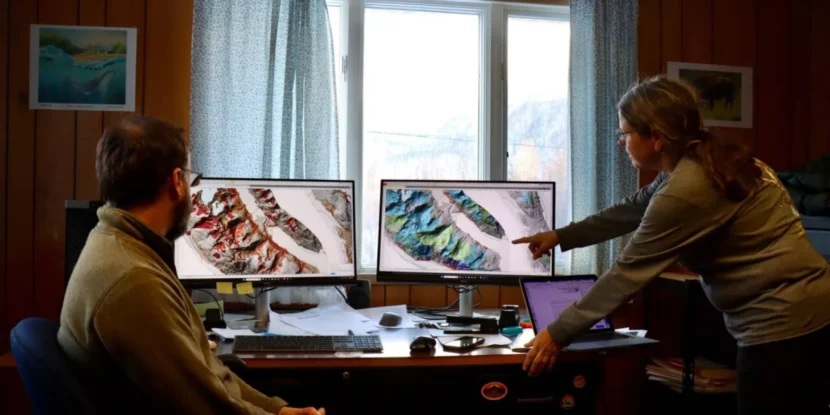
To understand what’s happening under the ice, Riverman and her team ski out onto the Juneau icefield every summer and put out seismometers that measure vibrations. 

They strike the ice surface with a sledgehammer or shoot it with blank shotgun shells.

“We use those miniature earthquakes to study how thick the ice is and what materials sit underneath,” she said.

She also uses radar to pinpoint where pockets of water have formed, since water lubricates the ice and makes it flow faster. 

Other scientists look at glacier mass, a measure of how much glacier matter there is. Louis Sass is part of the oldest study of glacier mass in North America as a glaciologist with the U.S. Geological Survey’s Alaska Science Center. It’s called the Benchmark Glacier Project, and it started tracking a few of Alaska’s glaciers — Lemon Creek in Juneau, Wolverine on the Kenai Peninsula and Gulkana in the Alaska Range — in the 1950s and 60s.

Back then, Sass said, it wasn’t clear whether Alaska’s glaciers were retreating continuously, or if they had just retreated some after the Little Ice Age and then stabilized. 

“People didn’t really know what was happening, because people hadn’t paid really close attention,” Sass said. “There were just very few glaciers that had any sort of picture record or enough data.”

Sass and his team venture out to the same survey sites each spring and fall to calculate the change in mass. They dig pits into the snow or take cores and weigh it. Then they drill long stakes down into the glacier to measure the levels of snow and ice. This is all very similar to what was done back in the 1960s, Sass said.

But now, using satellite imagery, they calibrate that data with the elevation changes of those survey sites as they slide down toward the ocean — since ice melts faster at lower, hotter elevations. The sliding poses a research challenge, Sass said. 

On Wolverine Glacier in the Kenai Mountains, “a sinkhole opened up, and that section of the glacier just sort of disintegrated, and the ice beyond it all melted away” so they lost the survey site stationed there, Sass said. “We’ve had to replace sites that have disappeared on all the glaciers now, as they melted out — and it’s changing so much faster.”

Suicide Basin, the birthplace of Juneau’s annual glacial outburst floods, sits about two miles above the terminus of Mendenhall Glacier. On Aug. 5, 2023, nearly 13 billions gallons of water drained from the basin, triggering the most destructive glacial outburst flood in Juneau’s history. (Anna Canny/KTOO)

Rapid melting has created a relatively new problem for people who live in the path of the freezing water’s path: glacial outburst floods. 

In Juneau, Suicide Basin is a pool contained in steep rock and dammed by Mendenhall Glacier. During the summer, the pool fills with meltwater and puts pressure on the ice dam until it suddenly breaks and drains into Mendenhall Lake, which then floods parts of the neighborhood in the surrounding valley. 

Jamie Pierce is a hydrologist at the U.S. Geological Survey who monitors Suicide Basin. 

Equipment stationed in Mendenhall Lake shows Pierce early warning signs when a flood is coming. 

“Water temperature will plummet, that’s a big one,” he said. “Then, of course, the lake stage will start rising precipitously.”

One summer day in late June of 2018, when he was setting up some monitoring gear in Suicide Basin, he thought he was witnessing the dam break in real-time. Bubbles started to rise up to the water’s surface among floating icebergs. It was noisy — crackling and popping. 

“And then all of a sudden, a massive iceberg started to overturn, and it kind of set off a chain reaction,” Pierce said.

The glacier calved off a chunk of ice roughly 100 feet deep and 200 feet long. Pierce and his colleagues thought it was going to trigger the big release. It didn’t, but it showed the huge scale of change the glacier is going through, and meant that the ice dam went quite deep. 

Major questions remain about Alaska’s glaciers. How long will they last? How big can glacial outburst floods get? And what will happen when the ice is gone?

Researchers are chasing answers to help Alaskans navigate a rapidly changing relationship with ice.

Alaska hunters, researchers say whales and fish are changing their migration patterns in the warming climate

Two humpback whales feed in Beaufort Sea, northeast of Point Barrow. (Kate Stafford)

Catching salmon in the North Slope village of Kaktovik was unheard of not too long ago. But resident Robert Thompson says some fishermen now see salmon more regularly. About five years ago, he caught a dozen salmon – a small but noticeable number.

“Before it was unusual, and people would talk about it, that somebody got a salmon,” Thompson said. “Now it’s fairly common.”

Fishermen, hunters and researchers gathered at the Alaska Marine Science Symposium in Anchorage in January to discuss how several fish species and marine animals are changing their migration patterns in the warming climate. That includes humpbacks gaining new ground up north, bowheads expanding their diet and salmon observed in the Arctic.

Salmon are spawning in the Arctic

Elizabeth Mik’aq Lindley is a graduate student from Bethel who grew up fishing for salmon. Now she studies Pacific salmon in the Arctic.

In 2023, she and other researchers installed temperature loggers at the depth of salmon nests in several rivers – including the Anaktuvuk River, which runs through Gates of the Arctic National Park and Preserve.

“If it gets too cold, the stream can freeze straight through to the bottom, into these nests, and embryos will freeze and die,” Lindley said.

Anaktuvuk River is seen from above On Sept. 14, 2023.
Anaktuvuk River is seen from above On Sept. 14, 2023. (Peter Westley)

Temperature also influences incubation and when embryos will hatch and start making their way to the ocean.

But in a year of tracking the water temperature, the researchers never saw it get below freezing. They also estimated that salmon emerged around August. That’s later than in other parts of the state, but it’s the optimal time for the Arctic. While more data is needed to see if salmon populations are growing in Arctic rivers, the conditions seem survivable.

“Salmon are spawning in the Arctic,” Lindley said, “and it does seem like it’s thermally survivable, thermally possible and plausible that they can incubate and emerge at the right time, given these temperatures.”

Bowheads are expanding their foraging grounds

The warming environment has also been affecting bowhead whales.

Traditionally, bowheads travel south to spend their winters feeding on krill in the Bering Sea. But with ice conditions reshaping the zooplankton community, the animals have been delaying that migration — or even staying in the Chukchi and Beaufort Seas all winter.

Marine ecologist Clarissa Ribeiro Teixeira looked at the whales’ baleen plates to better understand the change. Elements that make up baleen plates – stable isotopes of nitrogen and carbon – can offer a window into an animal’s diet and movements. Each plate grows continuously and has information from about 20 years of the whale’s life, she said.

Marine ecologist Clarissa Ribeiro Teixeira speaks during the Alaska Marine Science Symposium on Jan. 30, 2025.
Marine ecologist Clarissa Ribeiro Teixeira speaks during the Alaska Marine Science Symposium on Jan. 30, 2025. (Alena Naiden)

Teixeira and her colleagues sampled baleen sections from 11 whales harvested on the North Slope over two decades. They also looked at the ice conditions during those years. What they discovered was that after 2016, when there was very little ice, bowheads shifted their behavior.

“The reduction in the sea ice cover may have influenced the prey availability distribution for these animals, motivating bowhead whales to explore new foraging habitats or include a wider composition of their prey sources into their diet,” she said. “That’s amazing, because it shows how resilient these individuals are, right?”

Humpbacks are frequenting the Arctic

Less ice might also mean new territory for humpback whales.

Kate Stafford, who is an oceanographer and a professor at the Marine Mammal Institute at Oregon State University, studies bowheads in the Arctic. But in 2021, she and her late colleague Craig George saw a whale that, to their surprise, turned out to be a humpback – a species that was once rare in the Utqiaġvik area.

“You just never know what you’re going to find,” she said. “We all need to take our eyes off of our phones and watch the water.”

Birds surround a humpback whale in Beaufort Sea.
Birds surround a humpback whale in Beaufort Sea. (Kate Stafford)

Stafford says data from local whalers and aerial surveys points to more humpbacks visiting the area.

In Utqiagvik, humpbacks were sighted only twice before 2021 and two or three times in years after that. Then, last fall, researchers saw more than 25 whales feeding close together for two days in a row.

“We came across what I would call Humpback Palooza,” Stafford said. “Just dozens of humpback whales, which was crazy.”

Researchers took photos of whales and uploaded them to Happywhale, a citizen science project that helps identify whales using a technology similar to face recognition. Several of the whales seen near Utqiaġvik matched whales seen in Hawaii breeding grounds.

Young humpbacks usually follow the migration patterns they learn from their mothers, Stafford said. Because researchers observed multiple mother-calf pairs, the whales might return to the area.

“This does suggest, at least to me, that humpbacks are here to stay near Utqiaġvik, at least so long as there’s something to eat,” she said.

Kate Stafford speaks during the Alaska Marine Science Symposium on Jan. 30, 2025.
Kate Stafford speaks during the Alaska Marine Science Symposium on Jan. 30, 2025. (Alena Naiden)

Utqiaġvik whaler Michael Donovan said he did not witness Humpback Palooza, but he has seen a few humpbacks during his fall hunts. He said that he and other whalers are worried the humpback whales might be competing with bowheads — a staple subsistence resource for his community — for krill and copepods.

“They’re an invasive species, you know. They come in and eat the same food that our bowheads eat,” Donovan said.

Donovan and other hunters say they support scientists studying species that are growing their presence in the Arctic’s warming waters. Meanwhile, Stafford said scientists rely on people like Donovan for their research.

“The hunters and whalers, they’re really good naturalists, they’re really good observers and biologists,” she said. “They need to understand the seasonality of animals, the behavior of animals, how the environment impacts animals.”

Stafford says that local hunters contribute so much to her research, she’s grateful when her work can help them, too.

Alaska’s glaciers are melting faster than anywhere else

The Mendenhall Glacier on Friday, Feb. 21, 2025. (Photo by Clarise Larson/KTOO)

Every year, hundreds of thousands of tourists flock to Glacier Bay National Park in Southeast to see towering ice formations hanging over the water.

But that ice is melting. And fast.

A new report published last week in the journal Nature examines the trend here and in 18 other regions across the globe, including the Alps, Andes and Himalayas. Researchers concluded that the world’s glaciers have lost about 5% of their ice since 2000 – and that they’re melting faster than ever.

But Alaska takes the cake. The report says the state’s glaciers have shrunk by more than 8% over the same time period – the fastest of any region. All told, Alaska alone accounts for the largest chunk, or nearly a quarter, of global glacier loss.

“Alaska is ahead of the curve in terms of losing its glaciers,” said report co-author Tyler Sutterly, a scientist at the University of Washington’s Polar Science Center.

Alaska has a lot of glaciers to lose

It’s an important finding that Alaskans and visitors alike can see with their own eyes, Suttlery added.

“You go to the ice fields in Alaska, you can see visually the bathtub ring of where those glaciers were a few decades ago and where they are now,” he said. “All a glacier expert does is take that stuff that you can see by the eye, by going to these ice fields, and just putting it all together.”

Alaska is warming two to three times faster than the global average, according to the 2023 National Climate Assessment. And the state has a lot of glaciers to lose. According to the National Park Service, Alaska is home to nearly 20,000 glaciers, which cover an area nearly the size of West Virginia.

The vast majority of melting is happening in mountainous, coastal regions like Southeast, where glaciers are more concentrated. Glacier Bay National Park, for instance, has lost about 20% of its glacial area since 1985.

“A phenomenal metric for measuring climate change”

The new report in Nature is the result of a collaboration between dozens of international scientists who study glaciers and how they’re responding to climate change. Sutterly says the goal was to compare, contrast and combine more than 200 regional estimates of glacier weight to develop one of the most comprehensive understandings of glacier loss worldwide.

“Tens of thousands of glaciers taken together are a phenomenal metric for measuring climate change,” Sutterly said.

Scientists use a range of methods to get that measurement. Satellite imagery can be used to create three dimensional pictures of glaciers. Radars and lasers fired from space help measure changes in topography. And another method, called gravimetry, gauges earth’s gravity field to shed light on things like ocean circulation and the growth and loss of glaciers.

Scientists have conducted similar research on the massive ice sheets in Greenland and Antarctica. But this project instead looks at the smaller glaciers that are found in more places.

It’s a more challenging task, Sutterly said, because they’re smaller, more difficult to see from space, and located in less accessible places. Think: the ragged mountains that tower over Haines, Skagway and Gustavus. But they’re also crucial sources of information – and have major impacts on nearby ecosystems and communities.

“So these are individually smaller, but are huge parts of the landscape, and are very important for freshwater resources, tourism, river health,” Sutterly said.

Communities in Southeast Alaska are mapping their landslide risk. It’s complicated.

Members of the Haines Planning Commission examine new maps that illustrate landslide risk in the area. The maps are meant to inform future development and planning decisions. (Avery Ellfeldt/KHNS)

If you drive north on Lutak Road in Haines, you’ll see snow-covered peaks towering over the ocean below. If you look closer, you might notice something else: vertical gashes running down the mountain face. They mark places where landslides – or maybe avalanches – have struck, taking trees, soil and rocks down with them.

Patty Brown chairs the Haines Planning Commision. She pointed to one of the slide paths while out for a drive on a cold, clear day back in January.

“There’s probably been a history of different slides reshaping what that whole face even looks like,” Brown said. “All this is slide, slide, slide.”

new report aims to address that reality by mapping the local landscape and pinpointing areas that might be more prone to slides down the line. The goal: providing homeowners and the local government with a science-backed tool that can be used to gauge landslide susceptibility, and to plan accordingly.

The multi-year effort, which was paid for with federal funding, began after an atmospheric river dumped record levels of rain on Haines in 2020. The storm washed out roads and triggered landslides, including one that killed two beloved community members.

“It was associated with such a radical weather event,” Brown said. “Those are going to keep getting more dramatic and be beyond what we predicted. So we better have some kind of an inventory of what to expect.”

The 2020 event and resulting maps are part of a bigger story about intensifying natural disasters – and how communities across Alaska and the U.S. are responding. As climate change and development fuel more destructive disasters including floods, slides and wildfires, local governments are trying to get ahead of the problem without also threatening homes and livelihoods.

Mapping efforts  and pushback  across Southeast

The Haines report is composed of three different maps, which were published in January by the Alaska Department of Natural Resources. The maps were made using light detection and ranging technology, also known as lidar, which researchers attach to planes, drones or helicopters to fly over a study area. The lidar sends down light pulses that bounce off the trees, buildings and the ground. The time it takes for the pulses to return provides detailed data about the landscape and what’s on it.

“So you can think of it kind of like a flashlight that’s shining down. Where does that light hit? Where does it pass through?” said report co-author Jillian Nicolazzo, a geologist with the Landslide Hazards program at the Department of Natural Resources.

The data is then used to create the maps, which local governments, communities and homeowners can reference when making crucial decisions about where to build housing, roads, schools and more.

“If we’ve identified an area that might be susceptible to landsliding, and in 15 years someone wants to put a subdivision in that area, well, hopefully they’ll see that we’ve identified it as a higher hazard area, and they’ll take a closer look,” Nicolazzo said.

Haines is not the only community interested in mapping the risk. Similar projects have been completed or are underway in more than half a dozen other communities in Southeast, in part due to four fatal landslides in the last decade. Those disasters happened in SitkaKetchikan, Haines and Wrangell.

But the efforts aren’t without controversy. Efforts to map physical hazards have sparked opposition in Alaska, but also in other places, like New Orleans and Oregon. The pushback has typically come from homeowners who don’t want the state or local government to label their properties as high risk out of fear it will drive down their property values and make it more difficult to get insurance.

Ron Heintz is a senior researcher at the Sitka Sound Science Center, a nonprofit that’s played a key role in confronting landslide risk in Southeast. He said the issue routinely comes up during conversations about landslide risk in Alaska.

“Everybody wants to see a hazard map, and they want to see if they’re exposed to any sort of hazard. But they don’t want any sort of official acceptance or understanding of these hazard maps,” Heintz said.

Take Juneau. In 2020, the local assembly commissioned new hazard maps, which placed some neighborhoods in landslide zones for the first time. The move drew widespread concerns that the maps would drive down property values or impact insurance. Later, in 2023, the assembly decided against formally adopting the maps and eliminated landslide restrictions from the city’s land use code.

Todd Winkel is a Haines resident who owns property right next to the fatal 2020 slide. He said people in Sitka warned Haines residents to push back against potential risk mapping after the disaster.

That was partially due to worries over real estate. But Winkel said it was also because people felt the mapping would only be beneficial if the local government focused on helping landowners mitigate the risk. Winkel agrees. He said Haines should focus instead on reducing the threat in areas that are clearly landslide-prone.

“If you’re not going to do anything, don’t risk assess it,” Winkel said.

Risks can hide in plain sight

The Haines Planning Commission, for its part, hopes the maps will help the community better gauge and respond to the risk, both during future extreme weather events and when making long-term planning decisions.

That could include encouraging people to consult an engineer before developing somewhere that’s landslide prone, said Derek Poinsette, the planning commission’s vice chair.

Poinsette emphasized that the commission does not currently plan to use the maps for regulatory purposes, such as vetting building permits – and that the maps have a few important limitations.

Key among them is that they do not predict where slides will happen in the future. Instead, they identify areas that may be more susceptible to slides due to the slope angle, vegetation and more. Another caveat, he said, is that the maps rely heavily on lidar, which provides important information but is not the same as verifying the risk in the field.

“This isn’t the last word on any specific area,” Poinsette said. “Getting out there on the ground and actually taking soil samples and drilling cores and things like that is what ultimately needs to happen to do a final engineering type assessment for any location.”

Back in the car, Brown, the commission chair, said there is a long history of landslides in Haines, and that the community is highly attuned to that reality. Still, she said, the deadly landslide in 2020 made at least one thing clear: the risk can hide in plain sight.

“It was a forested slope, and we like to be confident – ‘Oh, it’s got plenty of vegetation holding the soil.’ But it’s steep. Once something’s really forested, I think you lose track of how steep it actually is under there,” Brown said.

“Part of what we have to pay to live in such a beautiful, dramatic landscape is sometimes, the drama looks like this,” she added.

The threat is only growing as temperatures rise – and weather grows more extreme – with climate change.

Landslide researchers have more clues about what caused Wrangell’s devastating 2023 slide

Wrangell’s landslide 11 months after on Oct. 13, 2024. (Colette Czarnecki/KSTK)

It’s been over a year since a landslide devastated the Wrangell community, killing six people. Last month, geologists presented their work from a visit to the slide over the summer.

Margaret Darrow, a professor of geological engineering at the University of Alaska Fairbanks, has been studying the landslide with her colleagues. She said their research is still in the works, but they’re inching closer to answers.

“My greatest hope is that whatever we find from this work will be able to tell the community of Wrangell why this slide might have happened, where it happened, where other slides could happen, so that you could use it in community planning,” Darrow said.

So far, they’ve found that the slope held an unusual amount of loose material waiting to be set in motion – and that the muskegs on top of the ridge may have played a role in doing that.

A surprisingly large volume of loose material

Their soil and rock samples are still being processed, but so far the researchers can say that the soil where the landslide happened is unusually loose. It sits on top of glacial sediment, which acts like a barrier against water. That could have been a huge contributor to the slide.

Annette Patton, a geologist at Oregon State University, said there was a surprisingly large volume of the loose material.

“A lot of the hill slopes around Southeast Alaska have really thin soils because it’s just so steep and material can kind of slide right down,” she said. “But part of why this landslide was so large is because there was actually a very anomalously thick layer of very loose material.”

She said the team looked at records of old landslides in the area. They think the 2023 landslide — which took out about 200 trees — happened right below what they think was an older slide.

“We just wanted to show this as an example of the fact that there is a lot of movement and activity that’s happened on this hill slope since the last glacial maximum,” Patton said. “And there’s a lot that we don’t understand about exactly how that might play out.”

She said there was a large storm the day of the landslide of a type known as an atmospheric river, but it wasn’t out of the ordinary for Southeast Alaska.

“Something notable here is that it wasn’t a really extreme storm,” Patton said. “It had a return period of about one year. So it’s like a big winter storm, but the kind of storm that maybe happens at least once a year.”

But the rainfall monitoring was done only at the airport, 11 miles away from the landslide and at sea level. That monitoring system recorded a little over an inch of rain during the six hours before the slide. Some Wrangell residents said they recorded three inches of rain that day, closer to the slide.

“These are really common types of storms,” Patton said. “Most landslides are triggered by atmospheric rivers here in Southeast Alaska. But not all atmospheric rivers trigger landslides.”

But Patton said there was a lot of water on the slope — and it mobilized all of that loose material.

More than twice as big as any known Wrangell slide

Her colleague, Josh Roering, a professor at the University of Oregon, said that the U.S. Forest Service started paying attention to landslides in the 70s, and a lot of their research came out of Wrangell and Prince of Wales.

“You’re really in the epicenter of a lot of amazing discoveries that have continued to affect how we think about these processes that led to the Forest Service mapping landslides every year across the region,” he said. “The map for Wrangell includes 256 landslides.”

He said it’s helpful to look at all the surrounding landslides in order to contextualize the massive one from 2023.

“It was more than twice as big as the next biggest slide that’s happened on Wrangell,” he said. “This was truly an extreme, anomalous event in terms of size, compared to what has happened here before. So this really led us to ask the question, ‘What is so different about that setting that allowed it to behave so differently?’”

He said they were also able to use the LIDAR data from the State Division of Geological and Geophysical Science. The department surveyed the area months before the landslide happened. The department also surveyed the area after the slide.

Roering said the first thing they noticed was some large ledges, or steps, exposing the bedrock.

“These are really big steps,” he said. “Looking at it from the road does not prepare you for how big they are in person.”

He said the erosion wasn’t consistent throughout the slide — most of it happened at the steep bedrock steps. And they even found living blueberry bushes right below some of those cliffs.

Roering said that implies the slide came down and almost launched from one ledge down to the next — which would only be possible if the soil was liquefied. And that would take an enormous amount of water .

“This field work occurred in August of 2024 so about six, seven months ago, and it was still really, really wet,” he said. “It hadn’t rained in a while, weeks before we were there. Yet there’s still what we call seepage – a lot of drainage from the landscape above the scarp that was coming into this side.”

The muskegs on the ridgetop

Roering said they wanted to know where the water came from, so they used previous LIDAR data to find the path from the top of the ridge to the beginning of the slide.

“As we follow these flow paths, they go up another set of bedrock ledges, and then they get up on top of the ridge,” he said. “We spent a lot of time up here on this ridgetop muskeg, trying to imagine the plumbing system for how this works, how the water goes up and down, how it spills out in some places and not others.”

He said they put in hydrologic sensors that test water levels that will help them understand when and how much water gets channeled down from the ridgetop muskegs. The researchers will get the sensors 14 months after installing them. They’ll see if the water levels remain constant or fluctuate a lot during the time period.

Roering said the muskegs only form here in areas of flat land — not where the ridge is too steep. And they can hold a lot of water and channel it downhill.

“In some ways, having channels to take that water out is a good thing, but in a lot of cases, having channels funnel water to one location where there’s a lot of loose material is obviously a really bad thing,” he said.

Roering wrote in an email that the likelihood of another landslide happening in the same area is low because the scar left behind doesn’t have much material left to be mobilized.

The researchers also gave tips for recognizing when a landslide might be about to happen — like sudden changes in water flow or color. Another indicator would be sound — some have compared it to a falling jet or a tornado. The researchers said that once people hear a landslide, they only have moments to get out of the way.

They also encouraged people to pay attention to weather forecasts, as landslides usually happen during intense rainfall. People can report a landslide on Alaska Landslide Reporter, an app that the state of Alaska recently released.

How a warming climate is part of a shift in sled dog genetics

Sled dogs line up along the frozen Kuskokwim River for the start of the 2025 Holiday Classic sled dog race on Jan. 16, 2025. (MaryCait Dolan/KYUK)

In an archival video of the 1988 Kuskokwim 300 Sled Dog Race or K300, the start line of the race looks distinctly of its time: spectators wear aviator glasses, turtlenecks, and a lot of teal. But it’s not just the people that look different from today, it’s also the dogs.

Broad-chested sled dogs bark at the start line, black and white fuzzy arctic coats alive with energy. Decades later, the dogs at the 2025 start of the K300 Race Committee’s Season Opener look different. They sport slender builds and thinner fur of brown and black.

Spectators gather and dogs bark eagerly at the 1988 Kuskokwim 300 start line. (KYUK File)

The tradition of dog mushing has changed a lot throughout its rich history in Alaska. While some changes come from development in the sport, others have been forced by a changing climate. One part of the story is told in the DNA of the dogs themselves.

It’s a shift Carl Erhart has noticed. His personal history with mushing goes back to his grandmother, a Koyukon Athabaskan Alaska Native from Tanana.

“She was the one who originally had dogs back then for transportation,” remembered Erhart. “Everybody had dogs.”

Erhart, a third-generation musher, lives in Fairbanks with his team of 35 dogs. He and his wife, Jennifer Probert Erhart, train and compete in global competitions. They’ve raised their kids on the sport and Erhart said that he cooks for his dogs daily. To say it’s a huge part of their lives would be an understatement. Dog sled racing is their life, as is true for mushers across Alaska.

But growing up in Tanana, Erhart heard stories about a different time. His dad remembers days when dogs pulled sleds to haul wood and water, protect from predators, and travel between villages. Back then, most families had a small team of three to five Alaskan malamutes, and later Siberian huskies, built for the Alaskan cold with thick fur coats and strong builds.

“But these weren’t race dogs by any means,” Earhart distinguished. “These were your companions, your work dogs, you know. A lot different, a different breed than we have now.”

Today, Erhart’s dog team and the life he leads as an Alaskan musher is a game of telephone away from what it was mere generations ago. A series of, in some cases, literal mutations have re-molded the mushing his dad remembers.

“How dog mushing and racing kind of came about in the villages a long time ago was exactly that. In the springtime, they would have carnivals and festivals where everybody gathered,” Erhart said. “And then it would just be human nature to say, ‘Hey, I bet my team is faster than yours.’ ‘Well, oh no, I bet my team is faster than yours.’”

As snowmachines were introduced and commercial goods became a more reliable supplement to subsistence, the tradition survived primarily as a competitive sport. And that posed a problem for work dogs.

“Those dogs could survive the elements really well, not burn a lot of food to stay warm,” said Erhart. “And they were really strong, but something they lacked was those big Siberian huskies don’t have good stamina, so they can’t go on long, long runs like we do nowadays.”

Suddenly, new traits emerged as favorable in the sled dog gene pool. A dog that was lean and fast and could muster a lot of energy was the kind of dog you needed to win a race. Around the early 1900s, the breeding game began.

The Alaskan husky, with ancestral roots in the native village dogs of Alaska’s interior and coast, began being bred selectively to yield a faster race dog. But Erhart said that at the same time, a shifting set of climate conditions played a role in what traits could make for the most competitive canine athlete.

“And then global warming kind of comes around, right? And we get less favorable snow conditions in the winter, and then we’re a little bit warmer in the spring. So now, when we’re having these races, these old Alaska(n) huskies, we’re having to perform in this hotter climate,” Erhart said.

A 1940s Pictoreels film depicts Chinook sled dogs , a popular breed at the time, frolicking in New Hampshire snow. (Courtesy of Pictoreels)

Genes from dogs in climates around the world entered the mix to match the Arctic’s shifting conditions. The Alaskan huskies have been mixed and matched with Irish setters, greyhounds, German shorthaired pointers, and Saluki hounds.

“And the result of that is you have dogs that can perform well in hot, humid weather,” Erhart said.

On the Yukon-Kuskokwim Delta, musher Myron Angstman was a long-time competitor in the K300 and now chairs the race’s committee.

“The basic dog in Bethel in the 1970s was bigger, thicker. Heavier dogs with way more hair, and those kinds of dogs had existed in the villages for a long time,“ Angstman recalled.

Angstman said that in the K300 race specifically, you can still find some dogs that have lineage from breeds along the Yukon River. Less stocky than the Bethel village dog, he said that they were some of the earliest successful dogs in long distance racing, and had the kind of sleekness usually attributed to sprint dogs.

But Angstman remembers when a wave of sleeker breeds hit races in the ’70s, ’80s, and ’90s. Often, the faster breeds of dogs would come in with teams from Anchorage or Fairbanks. They quickly changed the game.

“And they’d look at the dog and they say, ‘Boy, that’s a fast dog,’” Angstman remembered. “And so rather than breed those, interbreed those with the slow dogs from the villages, they would often just breed the ones from Anchorage and Fairbanks with another Anchorage, Fairbanks dog. So they did a whole team full of faster dogs. And so the changeover was quick and dramatic.”

Mushers Maurice Andrews (left) and Aaron Alexie take off in the mass start of the 2024 Akiak Dash on Jan. 27, 2024. (Josiah Swope/KYUK)

But breeding for a warmer climate has had a ripple effect. The modern breeds can’t all be kenneled outside like the Alaskan malamute or the Siberian husky can. Some of the fastest dogs need to live in the house, which Erhart said isn’t feasible for someone like him with kids and grandkids. He said that it has caused a shift in the sport and who can do it.

“I’m like, ‘Yeah? At what cost to the Alaska(n) Husky are you the best right now?’” Erhart said. “Your dog literally cannot live outside. So in definition, it’s not an Alaska(n) husky sled dog. It’s a pet dog that’s fast.”

What was meant to keep a tie to the old ways has in some ways caused a divide. The tradition looks different than it once did, but there are also other domino effects at play when it comes to mushing and climate change.

The process of fueling dogs has changed as salmon crises build along the Yukon and Kuskokwim rivers. And shifts in the training of the sport are a new piece of the champion’s puzzle as snow has become more of a question than an Alaska staple. We’ll dive into those developments in stories to come.

This story is part of a series looking at the development of sled dog racing and the impact of climate change on mushing in the lead-up to the 2025 K300 race on Feb. 7. Stay tuned for the next parts of the series on KYUK 640AM and online at KYUK.org.

Site notifications
Update notification options
Subscribe to notifications