Climate Change

Although everyone has moved, Newtok’s relocation is far from over

Families first started moving from Newtok into new homes in Mertarvik in 2019. (Emily Schwing/KYUK)

The village that people know as Newtok is basically a ghost town today. What’s left of the public school has been packed into more than two dozen shipping containers. It will get shipped south later this year.

No one lives in any of the houses that remain in Newtok. The only thing still operating there is the diesel generator that keeps the local cell phone tower powered.

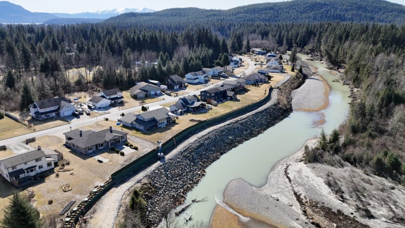
Newtok had to move because the permafrost under the community was deteriorating. As a result, the ground was sinking and the banks of the Ninglick River were eroding rapidly – about 70 feet of land washed away each year. It’s all the result of a changing climate. And in August 2024, the Newtok Village Council voted to evacuate the last of Newtok’s residents. The community had become too dangerous.

The ground under Newtok has been eroding for decades.
The ground under Newtok has been eroding for decades. (Emily Schwing/KYUK)

In the fall of 2024, the final residents of Newtok moved from the low lying tundra near the Bering Sea coast to higher, safer ground on a bluff 9 miles away. It’s an effort that’s been ongoing for decades, involving several federal and state agencies, private partners, and the local tribal government.

Another move

This wasn’t the first time people who called Newtok home were forced to move. Andy Patrick, 77, is one of the oldest living residents who still remembers the old village, Kayalivik.

“One day I was probably in the sled, I don’t know, probably two years old,” Patrick remembered. “I see dogs in front of me and I feel the wind. I looked back and asked my granny, and she told me, ‘We are moving.'”

Andy Patrick is one of only two people in Mertarvik who remember life in Kayalivik, an old village where people lived before they were forced by the federal Bureau of Indian Affairs to move to Newtok in the 1950s.
Andy Patrick is one of only two people in Mertarvik who remember life in Kayalivik, an old village where people lived before they were forced by the federal Bureau of Indian Affairs to move to Newtok in the 1950s. (Emily Schwing/KYUK)

When Patrick was a toddler, the United States government sent a barge loaded with construction materials up the Ninglick River. The goal was to build a school that would be operated by the U.S. Bureau of Indian Affairs (BIA). It got stuck near present-day Newtok, so the BIA decided to stay put and build the school there.

Even 70 years ago, Patrick said that Elders knew it wasn’t a spot that would be good for permanent settlement because the low-lying ground wasn’t stable.

“That’s what my grandma used to tell me,” Patrick said. “It’s going to start wobbling.”

Over the next three decades, it became clear that the Elders were right. In 1984, a consulting firm assessed erosion along the river bank on behalf of the Newtok tribe. The cover letter to the report stated: “Relocating Newtok would likely be less expensive than trying to hold back the Ninglick River.”

Just like the land, homes in Newtok were also deteriorating for many years. None of them were ever designed or built to withstand the harsh climate along the Bering Sea coast, which is known for driving wind and rain, unpredictable blizzards, and dramatic storms, particularly in the fall.

Xavier Paniyak felt the impact firsthand.

“When bad weather hits, I used to deal with it all the time. My floor always used to flood,” Paniyak said. “When I walked you could hear the water, like a squishy sound, and toward spring, when the weather started getting warm, you could smell that black mold and white mold aroma.”

Xavier Paniyak says he's happier and healthier in his new house in Mertarvik after moving across the Ninglick River from Newtok in 2024.
Xavier Paniyak says he’s happier and healthier in his new house in Mertarvik after moving across the Ninglick River from Newtok in 2024. (Emily Schwing/KYUK)

A new house

Planning for this most recent move, away from Newtok, got underway in the 1990s.

One of the biggest barriers to a complete relocation has been building enough housing at the new village site, Mertarvik.

Newtok residents started moving to Mertarvik back in 2019 and continued to do so, slowly, as houses became available.

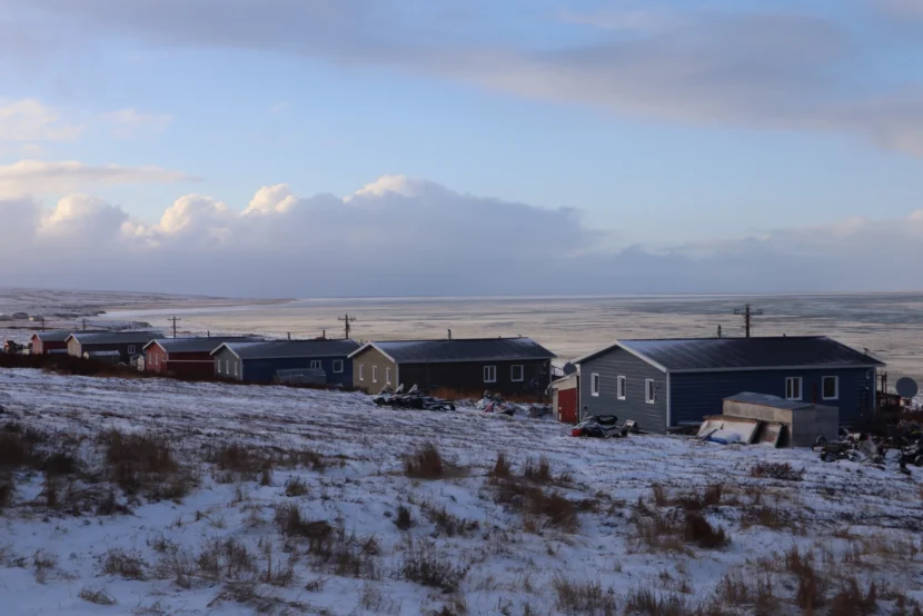
In 2024, Paniyak and his daughters finally got their turn to head across the Ninglick River. “I’m very, very, very much at home now. And this is for my kids. I’m not doing it for me,” he said.

Now, his family lives in a big blue house with a red metal roof at the end of Mertarvik’s new main road. The move has been revolutionary. His new house isn’t moldy. He’s had asthma for years, but he said that a lot of his symptoms are going away.

“Even my girls noticed I’m not grabbing for my rescue inhaler,” Paniyak said. He used Albuterol inhalers regularly back in Newtok because the mold in the walls of his old house affected his breathing. “[Now] I feel way better,” he said.

Three designs

Three different organizations have designed and built housing in Mertarvik. There are significant differences between Paniyak’s new house, built by the Association of Village Council Presidents, Regional Housing Authority, and his next door neighbor’s.

“I’m only gonna start paying when they fix this thing up,” said Philip Carl, who lives next door. His house was designed and built by an Anchorage-based company that the Newtok Village Council hired. Carl said that he stopped making payments to the tribe a few months ago because of the house’s poor condition.

Carl and his wife, Frieda, have noticed lots of problems, including water damage and gaps developing between the tops of the walls and the ceilings. There’s mold coming through the wood paneling on the ceiling, around window casings, and in the corner along the floor in one of the bedrooms. Frieda said that she does what she can to clean with bleach regularly to keep it from spreading.

Fifteen people live in her four-bedroom house. It’s less than three years old. While she said that she’s relieved her family is safe from the erosion over in Newtok, Frieda doesn’t think that her family is healthy in their new house in Mertarvik. She’s set up three air purifiers in her house to keep the air clean, but it’s not a permanent fix.

Frieda Carl and her granddaughter, Faith, are two of the15 people that live in a new house in Mertarvik that has some serious problems.
Frieda Carl and her granddaughter, Faith, are two of the15 people that live in a new house in Mertarvik that has some serious problems. (Emily Schwing/KYUK)

It’s not only the new houses that have problems. As the population in the new community has increased, the critical infrastructure, including water, sewage treatment, and electricity, has all been challenged in the last two years. These are all problems a move from Newtok was supposed to solve.

This reporting was supported by the Alaska Center for Excellence in Journalism.

Mendenhall Valley residents prepare for annual glacial outburst flood

Benjamin Coronell and S'eiltin Jamiann Hasselquist with the Juneau Tlingit and Haida Community Council fill sandbags in the parking lot behind Thunder Mountain Middle School. (Photo by Alix Soliman/KTOO
Benjamin Coronell and S’eiltin Jamiann Hasselquist with the Juneau Tlingit and Haida Community Council fill sandbags in the parking lot behind Thunder Mountain Middle School. (Photo by Alix Soliman/KTOO)

Dozens of Juneau residents in the glacial outburst flood zone filed into the Mendenhall Valley library on Saturday afternoon to learn how to prepare for flooding expected later this summer. 

Members of the Juneau Lions Club walked residents through the new flood map website made by UAS researchers and handed out weather alert radios. Local insurance providers talked about how FEMA’s National Flood Insurance Program (NFIP) works. The program is still operating, but that might change given the Trump administration’s past statements about weakening the agency. 

Reuben Willis, a State Farm insurance agent in Juneau, explained that the price for NFIP is based on FEMA’s risk zone maps, last updated in 2020. He recommended that homeowners lock in lower pricing before FEMA updates the city’s maps again. 

“If they change your zone and put you in a higher-risk zone, which would allow them to require us to charge a higher premium, if you purchased the policy you’re grandfathered in,” Willis said. 

He added that if homeowners with NFIP policies sell their place in the future, that grandfathered price transfers to the new owners. A new policy takes 30 days to go into effect, so Willis said Mendenhall Valley homeowners should consider applying now to protect their assets from potential flooding this year. Catastrophic floods hit neighborhoods during the first week of August the past two years.

Elizabeth Figus, a Valley resident whose home on View Drive flooded in 2023 and 2024, said that NFIP made a huge difference for her financially and shared tips for how to document losses after a flood. 

“If you are feeling stressed out after a flood, you might be urged to just throw stuff away,” Figus said.

But instead of tossing damaged property, she recommends taking photos of everything before moving it and cataloging each item — even small things like cleaning supplies. 

Residents who already have NFIP insurance raise their hands at the flood preparedness workshop on June 7, 2025. (Photo by Alix Soliman/KTOO)

Laird Jones has lived in the Valley since 1982. His place is on Skywood Lane, near the library. He said his home was spared during last year’s record-breaking 16-foot flood, but that could change if a future flood breaches 17 feet. Last year, he watched the water level rise too close for comfort.

“The ditch was full of water, and we had a salmon swimming by in the ditch,” he said.

He said FEMA maps put his home in one of the lower-risk zones, so when he got a quote for flood insurance, it was just under $360 per year. 

Insurance providers said that’s the base price for the program, but it can be around $2,000 for those in higher-risk zones. The standard policy covers $250,000 for residential structures and $100,000 for belongings inside.

In the parking lot behind Thunder Mountain Middle School, staff from the city and Tlingit and Haida, along with a handful of volunteers, filled free sandbags for residents to stack against their homes. The U.S. Army Corps of Engineers donated the bags, and the city and tribe evenly split the cost of the sand — about $18,000. Another sandbag event will take place on June 14. Tlingit and Haida will also host Community Emergency Response Team trainings on June 14, 21 and 28.

Anton Rieselbach, a program associate at the Juneau Economic Development Council, attended the event to talk with people about a survey to capture how the 2024 flood affected the community. 

“We want to figure out the gap between the amount of help that’s been given to flood victims and the amount of impact that they actually incurred,” Rieselbach said. “We also want to try to figure out some of the social impacts of the flooding — for example, is this flooding causing people to try to leave Juneau in higher numbers than usual? Is it causing people to have negative mental health experiences or any other health issues?”

He said getting a comprehensive picture of the issue will help inform future flood responses. So far, roughly 60 people have responded to the mail-in survey, and Rieselbach said the council is aiming to get 150 responses by the end of the month.

Juneau Assembly delays second extension of Mendenhall River levee

HESCO construction on Riverside Drive on April 2, 2025. (Photo by Alix Soliman/KTOO).

The Juneau Assembly voted to wait on a second extension of Juneau’s Mendenhall River levee until after this flood season. 

Assembly Member Greg Smith said the project to protect additional homes from annual flooding faces engineering and funding obstacles that can’t be solved before the flood expected later this summer.

“We don’t seem to have a way to fund this fairly this year, “ Smith said. “We don’t have a way to armor the bank and ensure the barriers are going to be properly installed this year… We want to do as much as we can, but this one just doesn’t seem to make sense to me.”

The city’s lawyer said there isn’t enough time to permit reinforcements for another section of the riverbank this summer. Without boulders to armor the bank from erosion, city officials said they aren’t confident that a second levee extension would hold up against a flood.

City officials also said the affected property owners would also need to vote on whether to create another local improvement district to divide the cost — estimated at more than $2 million

The levee extension, called phase 1B, would go from Kax̱dig̱oowu Héen Elementary School to Brotherhood Bridge on Glacier Highway. City Manager Katie Koester said the intention would be to protect 96 homes and commercial properties from an 18-foot flood. 

The likelihood of such a catastrophic flood is unknown, but the volume of water would have to be 50% higher than last year’s record-breaking 16-foot flood. 

“There would be 96 parcels if we did not do 1B that would flood in a 18-foot event. We would attempt to mitigate the impact on 30 of those parcels,” she said. 

Koester said this year the city will use large sandbags called supersacks to protect 30 properties on Meadow Lane that could see more water due to an initial levee extension that the Assembly approved last month.

The Assembly will consider the extension again next season, once city staff draft a plan to pay for it.  

UAS launches glacial outburst flood website for Mendenhall Valley residents

Water fills the streets and floods houses in the Mendenhall Valley early the morning of Tuesday, August 6, 2024. (Photo courtesy of Rich Ross)

Researchers launched an interactive glacial outburst flood website today to help Juneau’s Mendenhall Valley residents plan for annual floods. It’s a project of the University of Alaska Southeast and the Alaska Climate Adaptation Science Center. 

The website features flood inundation maps the city published earlier this month. Instead of being sliced into multiple 2D image files, the maps are stacked in layers on an interactive viewer. Residents can now scroll over their property to see the projected water depth for different flood heights.

That detail is new to the public. Eran Hood, an environmental science professor at UAS who led the project, said it will ideally help people understand the risk to their home when the National Weather Service puts out a flood forecast. 

“Well the main outcome is just to allow people to have more information to plan ahead,” Hood said.

A screenshot of the interactive map showing 5 feet of water projected on View Drive at a 16-foot flood with the HESCO barriers.

The website includes historical data and other information, like how Suicide Basin formed to create the floods and how scientists make flood forecasts. That information was already public, but Hood says it wasn’t accessible before.

“All of that stuff was somewhere, but it wasn’t in places where people probably ever would have found it,” he said. 

Now it’s all in one place.

Hood came up with the idea for the website. With a $30,000 grant from the Alaska Climate Adaptation Science Center, he hired a programmer named Sean Fagan to bring it to life. They hosted forums with residents to receive feedback on the website before launching it and incorporated suggestions to make things easier to understand. 

Hood says the new site compliments the National Weather Service’s Suicide Basin monitoring webpage, which is still the go-to spot for emergency flood information.

Middle school teacher in Juneau’s Mendenhall Valley brings glacial outburst science into the classroom

Thunder Mountain Middle School students hold up their glacial outburst flood projects beside their teacher, Jess Stanley. (Alix Soliman/KTOO)

Listen to this story:

Thunder Mountain Middle School sits beside Mendenhall River, which has surged over its banks and devastated homes in the Valley twice over the past two years. Floodwaters came close to inundating the school last year.  

Eighth grader Vivian Esmiol just learned why.

“The root problem is, well, it’s the Suicide Basin, which is between the Mendenhall Glacier,” she said. “It’s like a little area where water can build up, and the reason why it formed in the first place is because global warming, as we all know, has been melting down the glaciers.”

She described how rain and glacial meltwater collect in the basin over the spring and summer, causing pressure to build up against the ice. 

“Then, at once, it can burst through, like, an entire large amount of water,” Esmiol said. “That’s how these floodings are happening and why they’re happening yearly.”

The Mendenhall Glacier dams water in Suicide Basin. As the glacier calves, it could be creating more storage space for water. That could cause bigger glacial outburst floods in the future. (Photo by Anna Canny/KTOO)

She learned all of this in Jess Stanley’s Earth science class. Most students said they didn’t know what a glacial outburst flood was before taking the class.

“I came in absolutely clueless,” Esmiol said. “I’m surprised I didn’t even know about this stuff in the first place.”

Now, the students know all about the science behind how it happens, and what’s being done to protect their school and neighborhoods. They mapped the river, plotted rainfall and snowpack and learned about how the melting Mendenhall Glacier affects downstream communities. Local scientists even visited their class and walked them down to the river.

Stanley said this was her first year teaching Earth science at Thunder Mountain Middle School. Her goal was to engage the students on a topic that was close to home. 

“I just wanted to have an opportunity for the kids to learn something place-based, something that’s here — literally in the backyard of our school,” she said.

That approach to teaching about the climate clearly made an impression on the students. Allie Simonson is a seventh grader in the class. 

“I think it’s really cool we get to learn about something that’s happening right now. Because in school, usually you learn about stuff that’s gonna happen in the future or happened in the past,” Simonson said.

Now, when the students gaze out the big picture window in the common area at the end of the hall, they see bulldozers and a huge pile of sand by the river. The city is extending the levee further downstream to protect their school alongside several businesses and homes from possible floods that could be higher than those in the past.

Aiden Key stands in his backyard along the Mendenhall River. Juneau’s record breaking glacial outburst flood on August 5th, 2023 swept away most of his land. He worries that the eroded bank will make his home more vulnerable to future floods. (Photo by Anna Canny/KTOO)

Stanley said a row of trees is getting chopped down near the track and a gravel road has gone in for heavy machines to build the HESCO barriers that make up the levee. 

Ryder McMillan, an eighth grader, said the class learned about that project, too. 

“We talked a lot about HESCO barriers and how they’re being built,” he said. “The most interesting fact that I learned was that they’re really expensive to build, and you wouldn’t assume that because … you think they’re just like, little green blocks with a bunch of sand in them.”

In their notebooks, the students sketched HESCO barriers, including the small outflow pipes to drain rainwater. They also wrote their lingering questions about glacial outburst flooding — some that adults don’t have answers to yet. 

“Nobody really knows what we’re going to do to permanently fix the solution with the Suicide Basin flooding yet,” Esmiol said. “Of course, we have those HESCO barriers up. But besides that, people are still working on it. People are still making ideas, and that’s going to take a while.”

HESCO flood barriers line the Mendenhall River on Wednesday, April 2, 2025. (Photo by Clarise Larson/KTOO)

In the meantime, Esmiol said people should try to plan for flooding. For the last two years, the major outburst flood has occurred during the first week of August.

The students are taking what they’ve learned beyond the classroom. They’re making posters about how Valley residents can prepare for floods, featuring QR codes that link to more information. They plan to tack them up around town this summer. The kids say to pack an emergency kit, sign up for the city’s emergency alerts, and when the floodwater comes, don’t swim in it.

Murkowski introduces bill to renew funding for landslide projects nationwide

An aerial photo of a massive landslide that's come down onto a glacier from snowy mountains.
Haines pilot Paul Swanstrom spotted this massive landslide on the Lamplugh Glacier near Glacier Bay on June 28, 2016. (Photo courtesy Paul Swanstrom)

Sen. Lisa Murkowski introduced a bill last week that would reauthorize funds for landslide monitoring work across Southeast Alaska, including in Haines.

At issue is the National Landslide Preparedness Act. The legislation was originally passed in 2020 and has provided millions of dollars each year to agencies including the U.S. Geological Survey for landslide-related work.

But the funding was only approved through 2024. So Murkowski is working to reauthorize it, but this time through 2035.

“We must do everything we can to safeguard our communities and protect Alaskans from fatal natural disasters, and that is why I will continue to advocate for the reauthorization of this bill,” Murkowski said in a statement.

State officials say the original funding has played a major role in fueling Alaska’s efforts to respond to landslide risk, which is intensifying with climate change. Southeast has seen four fatal landslides over the last decade, including one that killed two people in Haines in 2020.

With the exception of some dollars from FEMA, “pretty much the entire” state landslide program is funded by the USGS, said Jillian Nicolazzo, the acting manager of that program, which is within the state Department of Geological and Geophysical Surveys.

“Without the USGS funding, we don’t have another pot of money to use,” Nicolazzo said.

The state has taken on a range of projects as a result of the national funding. Perhaps most important is a statewide inventory on where landslides have happened. Nicolazzo said that project is nearly complete, and will feed into a broader, national database.

Nicolazzo said it’s an important first step toward better understanding where landslides have already happened – and where they’re more likely to take place in the future.

“If we can see that a certain soil type, or a certain slope angle with a certain soil type have had more landslides, then maybe we can say the susceptibility is higher in those conditions,” she said.

The federal funding has also fueled work focused on Southeast weather stations.

Most towns already have weather stations at their airports. Those are critical for aviation purposes but insufficient for monitoring landslide risk across a broader area. Take Wrangell, where a landslide killed six people in 2023.

“People who lived by the Wrangell landslide said there was a lot more rain than what had been recorded at the airport,” Nicolazzo said. “And they suggested that the weather patterns had also been different than what had been recorded at the airport.”

The program helps maintain existing weather stations, including several in Haines. The station on Beach Road, for instance, needs maintenance. Nicolazzo said it looks like some animals have nibbled on wires, and that a bear may have disrupted some solar panels.

But the program also funds the construction of new stations. Nicolazzo said that could happen in Ketchikan and Petersburg this summer.

The reauthorization bill has been introduced in both the U.S. Senate and House of Representatives. The House Natural Resources Subcommittee on Energy and Mineral Resources is set to hold a hearing on the legislation this coming Tuesday.

Site notifications
Update notification options
Subscribe to notifications