Environment

The U.S. saw vivid northern lights as far south as Florida — and more could be coming

The Aurora Borealis lights up the night sky over Monroe, Wisconsin on Tuesday night.
The aurora borealis lit up the night sky over Monroe, Wis., on Tuesday night. The northern lights were visible as far south as Alabama and Florida (Ross Harried/NurPhoto via Getty Images)

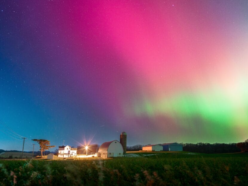
Geomagnetic storms brought the northern lights to much of the U.S. on Tuesday night, painting the sky in vibrant hues of green and pink.

The Aurora Borealis was spotted in a large swath of states, including Idaho, Iowa, Missouri, New Mexico, New York, Oklahoma, South Dakota, Tennessee, Texas and Washington state. Northern lights were visible as far south as parts of Florida and Alabama, a relatively rare occurrence that highlights the severity of this week’s storms.

“Well, we had activity tonight — a lot of geomagnetic storm activity,” Shawn Dahl, service coordinator at the National Oceanic and Atmospheric Administration’s (NOAA) Space Weather Prediction Center, said in a video on X.

The aurora borealis glows above rural Monroe County, Wis., as a strong geomagnetic storm from recent solar activity pushes the northern lights unusually far south on Wednesday.
The aurora borealis glows above rural Monroe County, Wis., as a strong geomagnetic storm from recent solar activity pushes the northern lights unusually far south on Wednesday. (Jeremy Hogan | Getty Images)

A geomagnetic storm happens when charged particles from the sun’s atmosphere interact with the Earth’s magnetic field. In addition to creating dazzling displays of color, such storms can disrupt technology on Earth, from satellites and GPS to radio communications and the power grid.

Tuesday’s activity was the result of a phenomenon called coronal mass ejections (CMEs), massive blasts of plasma and magnetic field from the sun’s outer atmosphere that grow in size as they hurtle towards Earth.

Two CMEs arrived on Earth on Tuesday, Dahl said.

The aurora borealis lights up the night sky east of Denver on Tuesday.
The aurora borealis lights up the night sky east of Denver on Tuesday. (Trevor Hughes | USA TODAY Network via Reuters)

The resulting storm reached G4 levels, the second-highest on NOAA’s five-step scale, and created a magnetic field that was “not only eight times stronger than what’s normal but … also favorable for continued activity,” Dahl said in a later update.

Forecasters are awaiting a third and final CME, which they expect will arrive on Earth at midday Wednesday and be even stronger than the previous two.

“That was the most energetic and strongest of this activity out there in space,” Dahl said. “It was traveling significantly faster than these other two, and we think that’s going to pack even a stronger punch than what we’ve already experienced.”

The Space Weather Prediction Center says the aurora may become visible “over much of the northern half of the country, and maybe as far south as Alabama to northern California.”

The Met Office, the U.K.’s national weather service, says the aurora may also be visible over parts of Britain on Wednesday night, though it is likely to be obscured by cloud cover — as was the case in Michigan on Tuesday.

Luckily, Americans in northern states won’t have to wait long for another chance to get a glimpse.

NOAA's Space Weather Prediction Center 'aurora viewline forecast' shows the swath of the northern U.S. in which the northern lights might be visible on Wednesday.
NOAA’s Space Weather Prediction Center “aurora viewline forecast” shows the swath of the northern U.S. in which the northern lights might be visible on Wednesday. (NOAA’s Space Weather Prediction Center)

How to see (and photograph!) the northern lights 

A dark setting is essential to see the aurora, so it’s important to get away from light pollution if you want a good glimpse of the northern lights. It’ll be easiest to see between 10 p.m. and 2 a.m. local time, according to NOAA.

A person watches the northern lights over Hulah Lake in northern Oklahoma on Tuesday.
A person watches the northern lights over Hulah Lake in northern Oklahoma on Tuesday. (Andy Dossett | USA TODAY Network via Reuters)

It is difficult to predict the exact timing and location of the northern lights, but you can sign up for different services that alert you when an aurora may be visible in your area. For example, a citizen science platform called Aurorasaurus allows users to report when and where they see an aurora, and gives estimates on how visible an aurora is in a given area.

Another option is an app called My Aurora Forecast & Alerts, available for download on both iOS and Android devices. This is a location-based app that gives viewing probability and forecasts.

Smartphone cameras are better at capturing the full array of an aurora than our naked eye, so be sure to go out with your phone to view a fuller spectrum of colors. If your phone camera has a night mode option, it’s best to switch it on when photographing the northern lights. You can also switch your phone camera to manual mode and adjust the exposure settings to get the perfect picture.

The aurora brightens the sky over Putnam Lake in Patterson, N.Y., on Tuesday.
The aurora brightens the sky over Putnam Lake in Patterson, N.Y., on Tuesday. (Frank Becerra Jr. | USA TODAY Network via Reuters)

Why we are seeing more northern lights 

Auroras have been happening more frequently in the United States for a while, and will continue to do so for several months. This influx of shimmering colors comes because the sun is reaching the peak of its 11-year cycle and, therefore, its solar maximum. The solar maximum causes solar eruptions, and this increase of activity brings ions, or electrically charged particles, closer to Earth. This stream of particles is known as the solar wind.

As solar winds get closer to Earth, the charged particles collide with gases in the Earth’s atmosphere. When they collide, light is emitted. The light emits at various wavelengths, creating a colorful display throughout the night sky.

When the sun is at its solar maximum, the number of solar eruptions increases, which is why there are more auroras in the sky. Usually, this activity only takes place near the Arctic Circle, but since solar activity is strong right now, viewing areas have expanded to other regions, like the Midwest.

Juneau’s avalanche forecasters prepare for winter snowfall

Mike Janes climbs up a weather tower to re-install snow sensors ahead of avalanche season. (Photo by Will Mader/KTOO)
Mike Janes climbs up a weather tower on Mount Roberts to re-install snow sensors ahead of avalanche season. (Photo by Will Mader/KTOO)

Listen to this story:

Juneau’s avalanche forecasters are gearing up for winter. The state Department of Transportation and the local electric utility re-installed scientific instruments to help them predict avalanche risk at their largest research site in town. 

Last month, avalanche forecaster Mike Janes rode the Goldbelt Tram, pulled on a harness and climbed a metal weather tower on the north-facing slope of Mount Roberts in the pouring rain.

“It gives us a baseline,” Janes said about the research site. “Here’s what the snowpack at this elevation in a sheltered area is doing.” 

Janes works at Alaska Electric Light & Power. He sets up sensors that will help predict the threat of avalanches once Juneau’s famous rain turns to snow. 

Mount Roberts and Mount Juneau loom over downtown. The steep slopes are marked by avalanches and landslides; their history is written in vertical chutes and tree rings. Avalanches are frequent in Juneau, but only a few have been disastrous. 

In 1962, an avalanche hit dozens of homes in the Behrends Neighborhood downtown. In 2008, a massive avalanche took out AEL&P’s main power line to Juneau, forcing the city to rely on diesel generators for two months. Since then, the utility has built barriers to protect its energy infrastructure from future slides. 

Janes said avalanches occur when a weak, unstable layer of snow forms, causing the layers of snow that accumulate on top to slide off. The instruments he installs on Mount Roberts will help him understand when that weak layer forms and where in the snowpack it is. 

Watch a video about avalanche forecasting in Juneau:

First, Janes attached a snow height sensor to a pole about 15 feet up the tower. It sends down sound waves, which bounce off the snow and back to the sensor, measuring the snowpack’s height. 

Then, he hung a string vertically from the tower that has nodes spaced 10 centimeters apart. That measures the various temperatures throughout layers of snow.

Next, Janes pointed to an instrument sticking off the side of the weather tower.

“That right up there — probably one of our most important instruments — that white cylinder with the black top,” he said. “That’s a heated tipping bucket, and that measures precipitation.”

It’s heated to melt snow, so forecasters can measure how much water is in the snowpack. Two more are lodged down the slope to measure water that’s melting beneath the snowpack.

Then he pointed to a small double-cylinder sensor called a net radiation meter. 

“That particular sensor is important for understanding when we’re getting weak layers forming at the surface that are going to become problems later,” he said. 

Earth gives off heat called long-wave radiation, which travels up through the snow and air and gets reflected back down to Earth by clouds that act as a thermal blanket. But on a clear night, that heat escapes into the atmosphere and can cause the top layer of snow to cool quickly, creating a sugar-like surface. 

“If that stuff gets buried, then it becomes like a future weak layer that avalanches can run on,” Janes said. 

This year, AEL&P, the Alaska Department of Transportation and other agencies will feed all of this data, and more, into a Swiss snowpack model. 

Patrick Dryer is an avalanche and geohazard specialist at DOT. He said using the Swiss model could help Alaskans better predict how layers of snow are forming at high elevations.

“That’s especially relevant in Alaska, where we have limited high elevation monitoring sites, but we have miles of roadway that we’re forecasting for,” Dryer said. 

He said using the emerging technology can help them make more informed decisions. Those decisions include things like setting off explosives to trigger avalanches before they become destructive, or putting barriers up to protect infrastructure in areas where avalanches happen frequently. 

But Dryer said there’s a lot of variability between where they collect data and all of the places where avalanches can occur. Plus, snow dynamics change, so no prediction is perfect. 

Learn more about the history of avalanches in Juneau with KTOO’s series, Alaska’s Avalanche Capital.

Alaska aims to regulate its own hazardous waste

Dead batteries are common household hazardous waste items that are accepted at Juneau’s hazardous waste facility. (Photo by Rosemarie Alexander/KTOO)

Alaska might soon regulate its own hazardous waste if the U.S. Environmental Protection Agency authorizes the Alaska Department of Environmental Conservation’s new hazardous waste program.

Alaska is one of only two U.S. states without an authorized program, the other being Iowa. That means the EPA regulates the generation, storage and disposal of the state’s hazardous waste. 

Lori Aldrich, the manager of the state’s new hazardous waste program, said the team consists of six DEC employees, including her, who have been training to take on the responsibility for the past three years. If the program gets federal approval, she said the team will take the lead on permitting, inspections and clean-ups instead of the EPA. 

“Honestly, for Alaska, it doesn’t mean that much change, except that you’re going to have somebody at ADEC here to call,” Aldrich said.

The state Legislature adopted new hazardous waste regulations in 2023 that went into effect this summer. For the most part, the state’s rules now mirror the federal rules under the Resource Conservation and Recovery Act.

According to the most recent EPA data, 2,729 tons of hazardous waste were generated in Alaska in 2023. The three largest producers were the Petro Star Valdez Refinery, Eielson Air Force Base — a Superfund site in Fairbanks — and a company that handles hazardous waste and spills. Together, they were responsible for 57% of the hazardous waste generated in Alaska that year.

Aldrich said Alaska’s generation rate is quite low compared to most other states, and one reason is that petroleum, on its own, is not categorized as hazardous waste. 

She said businesses commonly toss things like cleaning solvents, paint and oil contaminated with other chemicals, which are hazardous wastes. Some things are hazardous due to their toxicity, while others are hazardous because of how they react. 

For instance, “cylinder gas is a hazardous waste if you’re throwing it away, because it could blow up,” Aldrich said.

She said that if the program gets approved, her team will start with a lot of outreach to educate Alaskans about what counts as hazardous waste. 

“Getting people to manage it properly and to make sure that it’s not impacting health or environment here in Alaska is what’s the most important part of our job,” she said.

Aldrich said that almost all of the hazardous waste in Alaska is shipped to disposal facilities in the Lower 48, and that her team would only be in charge of the waste when it’s within state boundaries. 

The public comment period on the state’s application to the EPA is open until December 8.

NOAA cancels funding for data collection crucial to tsunami warning systems

A sign marking a tsunami evacuation route in Sand Point, Alaska on July 29, 2025.
A sign marking a tsunami evacuation route in Sand Point, Alaska on July 29, 2025.  (Theo Greenly/KDSP)

The National Oceanic and Atmospheric Administration is halting a contract that makes it possible for the federal agency to accurately monitor for potential tsunamis in Alaska – and quickly warn at-risk communities.

The Alaska Earthquake Center for decades has collected data from seismology stations across the state and directly fed the information to NOAA’s National Tsunami Center, in Palmer. If the data indicates an earthquake that could lead to a tsunami, the Tsunami Center sends out a warning message within minutes.

Or at least that’s how it worked historically, including on Thursday morning, when an earthquake struck between Seward and Homer.

But that’s about to change. In late September, the federal agency advised the Alaska Earthquake Center that it does not have funding available for that work.

“We are anticipating direct data feeds to stop in mid-November,” said Mike West, the Alaska State Seismologist and director of the Alaska Earthquake Center, which is part of the University of Alaska Fairbanks’ Geophysical Institute.

The news comes amid the Trump administration’s effort to dramatically slash federal spending – including by proposed cuts to key weather and climate programs within NOAA.

West said the change is a big deal. NOAA’s National Weather Service holds the federal responsibility for tsunami warnings, and has historically been a primary supporter of seismic data collection in Alaska. But the agency doesn’t actually collect much of that data itself.

“Without this contract,” West said, “they lose data from dozens and dozens of sites all around the state, and specifically – or maybe more urgently – a handful of sites out in the Aleutians and the Bering that have been there for decades specifically for this purpose.”

The potential fallout isn’t isolated to Alaska. West provided an example: the 1946 tsunami that originated near the Aleutians, and killed more than 150 people in Hawaii.

“The tsunami threats from Alaska are not just an Alaska problem,” West said.

The contract was supposed to re-start October 1. But after funding did not arrive as expected, West reached out to the agency on Sept. 23. A NOAA official advised him via email a week later that the agency did not have the budget to support the long-standing contract.

West said the Earthquake Center is grappling with the situation but that its NOAA data feeds and tsunami-specific work will wind down in November.

“We are not going to continue operating those stations in the Aleutians that are entirely NOAA supported,” he said. “We’re not going to just keep doing it.”

NOAA did not respond to a request for comment. NOAA Tsunami Warning Coordinator David Snider declined to comment for this story.

Juneau Assembly weighs cost of buyout for View Drive residents in flood zone

Don Habeger and Wayne Coogan walk on the top of a privately made berm that failed to protect Habeger’s home from flooding on View Drive in August 2025. (Photo by Clarise Larson/KTOO)

Listen to this story:

View Drive is the street hardest-hit by Juneau’s annual glacial outburst flood, and remains unprotected by the city’s temporary levee. The Juneau Assembly is hoping to avoid paying a portion of the cost for a federal program that would offer buyouts to those residents.

A federal buyout for View Drive would pay residents to leave, demolish their homes and transform the land into a park. But first, the city has to decide whether to sponsor it. At this point, it’s not clear if the Assembly will vote to do so. 

Mayor Beth Weldon was cautious at Thursday’s special Assembly meeting, where experts presented the city’s options.  

“I don’t think anybody’s ready to commit to anything tonight,” she said.

Brett Nelson is Alaska’s conservation engineer at the Natural Resources Conservation Service, or NRCS. The federal agency oversees a recovery buyout program. At the meeting, he explained that the City and Borough of Juneau would be responsible for 25% of the cost. 

If all 18 eligible properties participated, it would cost an estimated $25 million. That means the city would be on the hook for up to around $6 million. But he says it’s unlikely every household would take the deal.

The Assembly voted unanimously to request a waiver to pay. Nelson said it’s worth making the request, but he’s not sure it’s realistic that NRCS headquarters would approve it. 

“I’ll say this: it is not very often used,” Nelson said.

If the cost is not waived, the city could seek funding from other sources besides Juneau taxpayers, such as nonprofits. But there is one restriction on the city’s portion:

“The 25% cannot be from another federal source unless that other federal source comes with congressional language specifically indicating that it can be used as a match for federal dollars,” Nelson said.

He said it would take around a year to complete the process and that the agency would prefer to offer the buyout option to residents before the next flood, which is expected next summer. 

“This is an emergency program and we’d like to move as expeditiously as possible,” he said.

If the city does take on the project, NRCS will appraise the 18 homes on View Drive and then residents will choose whether to take the deal or stay. Nelson says there are two appraisal options: they can be done based on the value now, or as of the day before the 2024 flood — and the agency is leaning toward the latter.

That appraisal decision will apply to every eligible property and affect the overall price tag of the project, since homes are worth more before they’ve been damaged by repeated flooding. 

Engineers say that while a couple of properties on View Drive might benefit from a barrier, the whole street can’t be protected by the HESCO barriers that make up the temporary levee protecting most other Valley neighborhoods.

Mike Records is a hydraulic engineer at the Army Corps. He compared the hazard of putting HESCO barriers on View Drive to the danger of a mariner taking a dinghy across Lynn Canal during a storm. 

“View Drive basically sits on a moraine from the retreat of the Mendenhall Glacier, so that moraine is extremely porous,” Records said.

He said that means water would seep under a temporary levee and form a pool. That’s what happened to a property at the end of the street where residents decided to erect their own berm ahead of the flood this August.

“You’re building a reservoir — potential reservoir  — with homes in the middle and no way out,” Records said, referring to how View Drive is a dead-end street with a single entry and exit point.

He said he recognizes that it’s unfair not to protect View Drive residents who’ve faced flooding over and over, and that they’re in a “horrible situation.” But from an engineering perspective, he said the only way to protect households that decide to stay is to implement a long-term flood solution

Nelson says parcels that get bought out become restricted from development forever, so households that participate in the program couldn’t return to their former properties — even after a long-term solution is built. He says NRCS has already determined View Drive is eligible for a buyout and that federal funding would likely be available soon after the government shutdown ends, if the city decides to sponsor it.

Army Corps agrees to pay for HESCO barrier expansion, expedites long-term outburst flood solution

Mayor Beth Weldon and Daryl Downing, a program manager at the U.S. Army Corps of Engineers, sign the assistance agreement to enhance the temporary levee on Oct. 30, 2025. (Alix Soliman/KTOO)

Listen to this story:

The U.S. Army Corps of Engineers announced Thursday that it will pay the full cost to extend and repair Juneau’s temporary river levee meant to protect almost all Mendenhall Valley neighborhoods from glacial outburst floods in the near-term. And it will expedite its process to choose a long-term solution that will protect the entire Valley. 

The existing temporary levee is made of HESCO barriers — steel and mesh baskets filled with sand. It protected hundreds of homes from flooding by a slim margin during the record-breaking glacial outburst flood in August. At a special Juneau Assembly meeting Thursday, members signed an agreement accepting assistance from the Army Corps to enhance the temporary levee. 

After signing the agreement, Mayor Beth Weldon referenced a quip Assembly member Ella Adkison made moments before. 

“The Army Corps is going to do phase two and pay for it. So we truly appreciate the assistance, and as Miss Atkison says, there’s no take-backs,” Weldon said.

The agreement expands the levee both upstream and downstream, protecting many more homes and businesses along Mendenhall River. Phase 2 will go from Back Loop Bridge to just before Juneau International Airport. The city estimates the expansion will cost around $19 million to build. The agreement means the city will no longer have to debate controversial ways to pay for construction.

Daryl Downing, program manager at the Seattle District of the Army Corps, says the agency will cover HESCO design and installation, as well as armoring the banks. 

“What is not covered is going to be any sort of outreach the City and Borough of Juneau will need to do to secure rights of entry or any permitting requirements for these efforts,” Downing said. “Once the Corps installs these measures, they get turned over to the City and Borough of Juneau for operations and maintenance, and then removal as well.”

The Army Corps will also help repair the existing stretch of the flood barrier, which leaked and slumped during the flood this summer — sustaining about a million dollars in damage — and build it higher for the next flood. 

The agency aims to complete that work by July 15, 2026. For reference, the glacial outburst flood has struck during the first two weeks of August in each of the past three years. 

None of this funding will retroactively cover the cost to build Phase 1 of the levee — which is estimated at around $6 million. The Assembly passed a controversial funding scheme called a local improvement district, or LID, earlier this year to split 40% of the cost among more than 400 homeowners in the flood zone. 

At Thursday’s meeting, the Assembly voted not to close out the Phase 1 LID. The only Assembly member who objected was Nano Brooks. He asked if it would be possible to use some funds from the recently reappropriated $5 million that was pulled from the Capital Civic Center to reduce the residents’ portion. 

City Manager Katie Koester said that money could be used to care for future repairs and maintenance of the HESCO barriers. 

“In the end, it’s really your decision how much you want to use taxpayer dollars versus property owner dollars,” Koester said. 

Long-term solution in sight

The Army Corps made another major announcement Thursday.  It aims to finish its technical report, recommend a long-term flood solution, and design it by the end of May 2026. That’s several years faster than the process agency staff outlined at a public meeting in July.

John Rajek is the chief of the geotechnical and engineering services branch at the Alaska District of the Army Corps. 

“We plan on developing a preliminary design of the preferred flood control alternative, we’re going to prepare a planning-level cost estimate that’s going to help everybody understand the financial implications and basically help make informed decisions on the path forward,” Rajek said. “And then the third element is, we’re going to complete a draft environmental assessment of that alternative.”

Those options are a dam, a permanent levee, a bypass channel along the river, a tunnel to drain Suicide Basin or relocating buildings from the flood zone. 

Rajek says that in December, the Army Corps will hold a charette — a major planning meeting with federal and local agencies — to discuss the options and pick one.

Anonymous sources engaged in the agency’s process told KTOO that a tunnel through Bullard Mountain to drain Suicide Basin looks like the preferred option at this point, but Army Corps staff refused to comment. 

The Army Corps is seeking public comment on the long-term solution, which closes at the end of next month. The public affairs office requests comments to be submitted to public.affairs3@usace.army.mil.

Site notifications
Update notification options
Subscribe to notifications