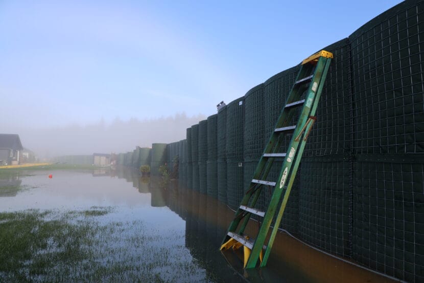
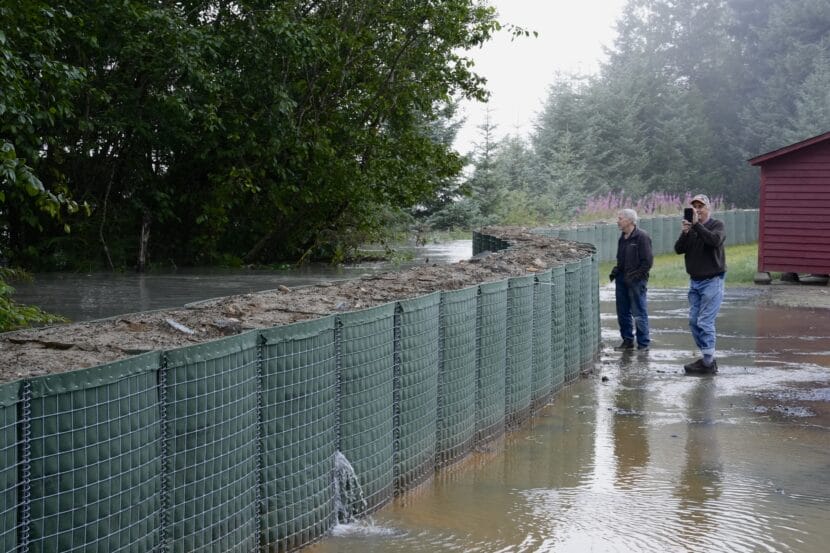
A ladder leans against HESCO barriers in the Mendenhall Valley on Wednesday morning, Aug. 13, 2025. (Photo by Clarise Larson/KTOO)
The flood reached a record-breaking crest of 16.65 feet at about 8:00 a.m. Water continues to seep into Valley neighborhoods.
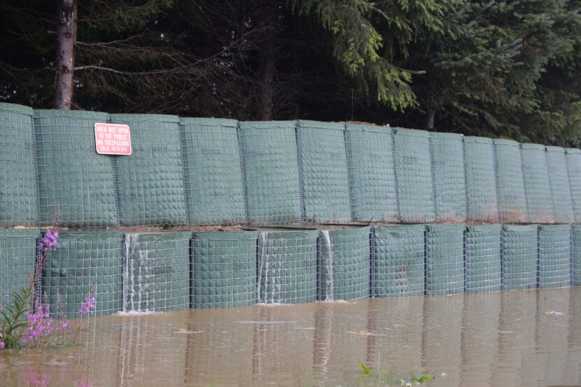
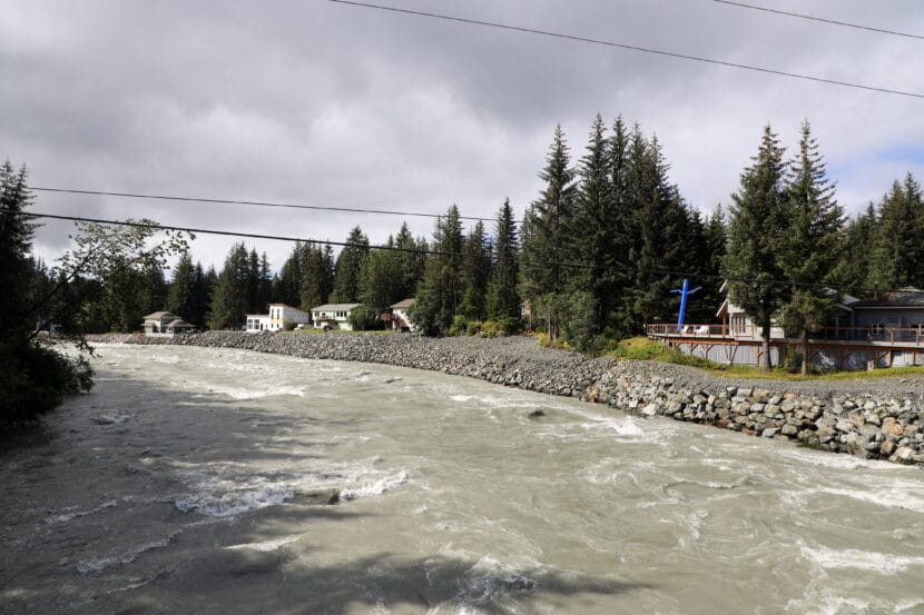
The HESCO barriers stacked in backyards along the river are blocking many homes from flooding, but water is seeping under and through the barriers on parts of Marion Drive, Killewich Drive, Meander Way and Riverside Drive. View Drive is flooded — that street is not protected by a barrier.
Some roads along the river have pooled with water, with multiple homes pumping water out of their crawlspaces. Alaska Electric Light & Power has cut power to some flood-affected streets.
Despite seepage, Ryan O’Shaughnessy, the city’s emergency program manager, says “there is no reason to believe there is imminent failure” of the HESCO barriers.
Some residents are reporting that water is reaching their properties when they hadn’t in prior floods. The city is helping residents pump out water from yards that have flooded.
The city is deploying supersacks to one section of the barriers where it appears a tree struck it — but no water has broken through at that point. The city continues to ask people to stay away from the area, and recommends evacuating immediately.
Water seeps between HESCO barriers installed along the Mendenhall River on Wednesday morning, Aug. 13, 2025. (Photo by Clarise Larson/KTOO)
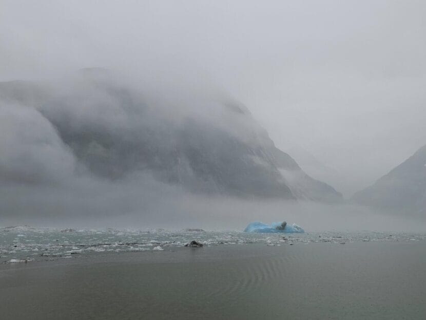
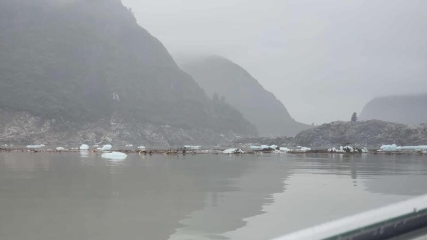
Ice and debris float in Tracy Arm on Monday, Aug. 11, 2025 following Sunday’s landslide. (Photo courtesy of Christine Smith)
Early Sunday morning, Sasha Calvey awoke to a roar.
“I look out of the tent, and then I see a massive wave coming, like, inches away,” Calvey said.
Calvey was camped with two friends, Billy White and Nick Heilgeist, on Harbor Island, an uninhabited islet in Holkham Bay. It’s at the convergence of two of Southeast Alaska’s most-visited fjords, Tracy Arm and Endicott Arm.
Calvey, White and Heilgeist had spent the past 78 days kayaking the Inside Passage from Washington. The three hoped to spend the final two weeks of their trip making their way to Glacier Bay.
It was 5:45 a.m. Sunday when their plans abruptly changed.
Calvey scrambled to wake up White and Heilgeist. The three are professional guides who have been taking a summer off from leading trips through the San Juan Islands. They’d pitched their tent in the woods, far from the high tide line.
They emerged to find much of their gear had vanished, swept away by the rush of water. Calvey’s kayak was floating a quarter mile off shore. White’s rested on a cliff. Heilgeist’s was in a tree.
“It was just pure chaos out of nowhere,” Heilgeist said. “All of it was just gone.”
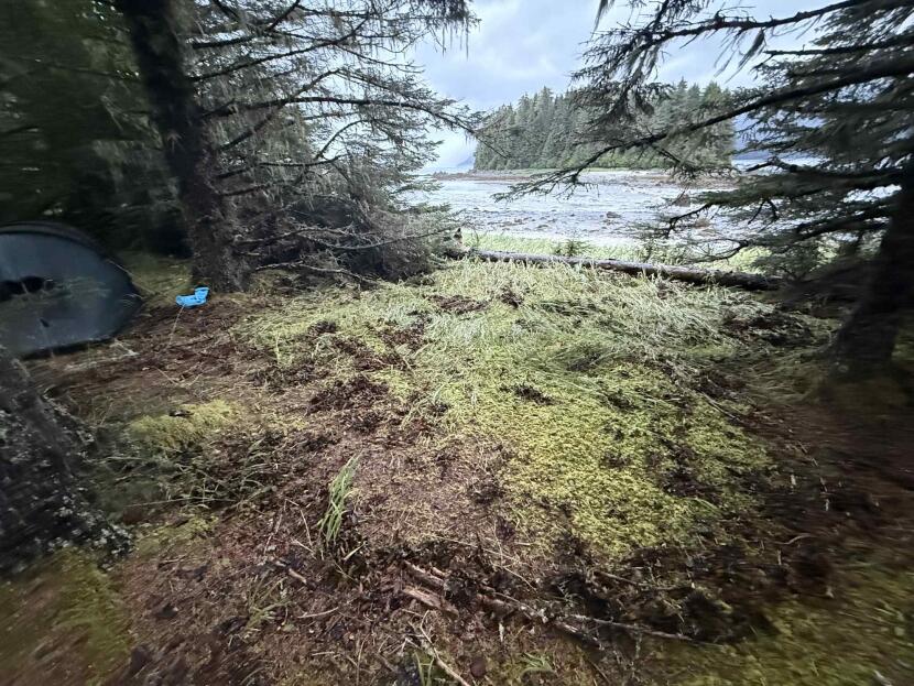
The kayakers were camped in the woods on Harbor Island, well above the high tide line. (Photo courtesy of Sasha Calvey)
‘Something was really different, and wrong’
Miles away, anchored near the entrance of a fjord known as Fords Terror, Christine White saw water moving backwards. She knew the area well — she’d been taking clients there aboard her small cruise ship, the David B., for nearly two decades. On Sunday, she saw the tide quickly rise and fall by roughly 10 feet.
“When we started seeing the water rising again on what should have been a falling tide, we knew something was really different, and wrong,” she said.
Smith reached out to a seismologist she knew, who consulted with colleagues at the Alaska Earthquake Center and the U.S. Geological Survey.
Smith was onto something. Seismometers across North America had rattled just a few minutes before.
“Honestly, I think of it as the side of a mountain collapsing,” said Michael West, the Alaska state seismologist.
Details of the remote landslide were uncertain in the immediate aftermath, but West said early indications are that a truly impressive amount of rock and debris tumbled down — tens or hundreds of millions of cubic meters.
“We’re talking about a cube of rock, that is, you know, a couple football fields on each side,” West said.
A truly colossal tsunami
Southeast Alaska has seen a growing number of fatal landslides near populated areas in recent years. But Sunday’s landslide was something quite a bit different. Rather than a top layer of soil giving way, in this case, large masses of bedrock came down, West said.
When all that rock fell near the end of Tracy Arm, where South Sawyer Glacier reaches tidewater, West said it set off a truly colossal tsunami. One photo, taken by Heilgeist after the trio was rescued by a charter yacht, shows an island deep in the fjord scoured of almost all vegetation.
A lone tree remains atop Sawyer Island, right, in Tracy Arm following a landslide-induced tsunami on Sunday, Aug. 10, 2025. (Photo courtesy of Nick Heilgeist)
“We’ll get better height estimates in the days to come, but even posts floating around on social media make pretty clear it was at least 100 feet tall in some areas near the source,” West said.
The wave continued to resonate for hours, he said, not unlike water sloshing in a bathtub. It even showed up on a tide gauge in Juneau, 75 miles north and around a few corners, with fluctuations of a foot or so evident several times in the hours after the landslide.
Smith, the captain, said she saw downed trees and scoured shorelines as the David B. made its way up Tracy Arm on Monday. Allen Marine tour boats had to turn around on trips up the fjord on Monday, according to Juneau-based operations manager Stuart MacDonald, though nearby Endicott Arm was free of debris.
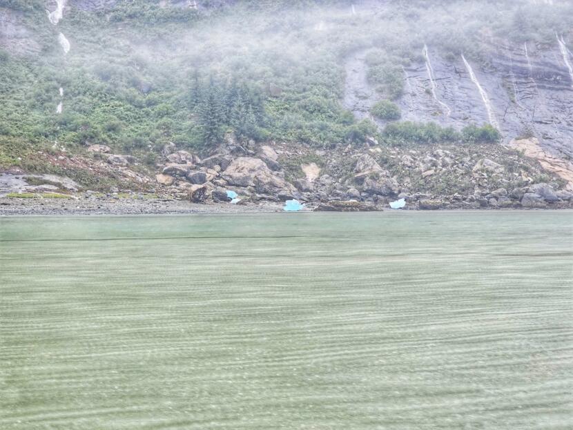
A shoreline in Tracy Arm shows the destruction left after a tsunami in this photo taken Monday, Aug. 11, 2025. (Photo courtesy of Christine Smith)
West spotlighted one early, intriguing piece of evidence — a series of small tremors before the bigger slide.
“Modest earthquakes, but hundreds or thousands of very small ones,” West said. “This landslide had a very clear precursory sequence, and that is not something we have often observed.”
Alaskans were lucky the slide happened when it did, West said. It was early in the morning — around 5:30 a.m. local time — so there weren’t tour boats or cruise ships in the fjord when the mass of rock fell.
“It is hard to imagine that, in front of the landslide itself, anything would survive,” West said.
Tsunamis like this ‘won’t always be in remote places’
West said the incident gives scientists a chance to learn more about how massive landslides like Sunday’s happen and what havoc they can wreak.
“We are in the rare position of being able to have these events that don’t have truly catastrophic impacts, sometimes just because we can tuck them away in remote places. But they won’t always be in remote places,” he said. “What they do present is a phenomenal opportunity to learn and better understand how these things work, so that when it’s in Whittier or Seward or Hoonah or Elfin Cove or wherever else, we’re better prepared for that.”
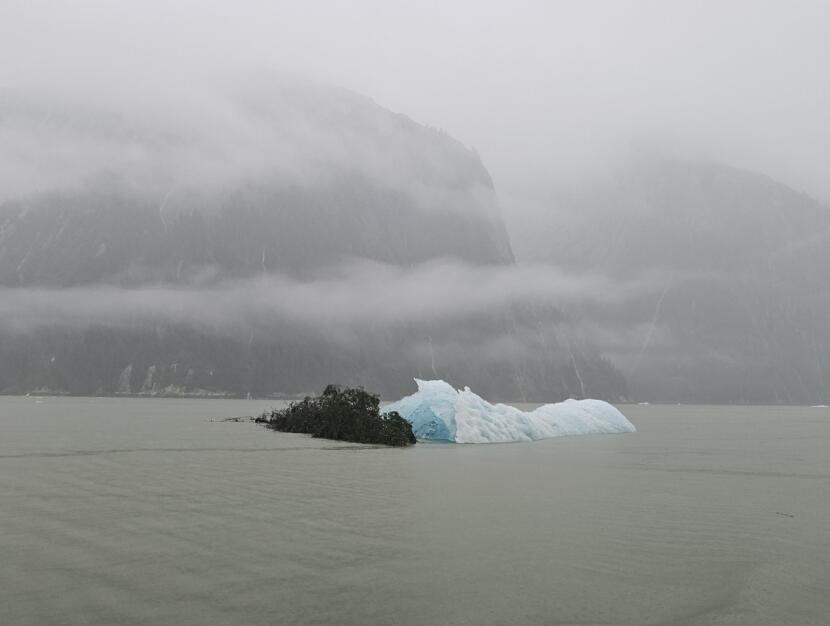
A tree and iceberg float in Tracy Arm following a landslide and tsunami on Monday, Aug. 11, 2025. (Photo courtesy of Christine Smith)
For the kayakers, the episode is a reminder that “sometimes, stuff just happens,” Heilgeist said.
The trio was rescued by a charter yacht, the Blackwood, which heard their distress call on a marine radio. A tender fought strong currents as the kayakers loaded what remained of their belongings onto the vessel. The crew welcomed them with blankets and showers, even taking them up Tracy Arm to see the damage the tsunami had left behind.
“Sawyer Island only had one tree left on it,” Heilgeist said.
For White, the entire experience feels “surreal,” she said, but she said the group is holding up well. More than a dozen Juneauites reached out to offer housing or logistical support. And while the group is raising money to replace the lost kayak and gear, White said she’s grateful they escaped any physical harm.
“I’m just glad that we’re all healthy and safe,” White said.
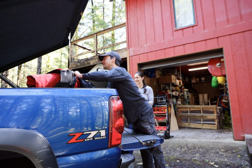
Malachi Thorington and Elizabeth Figus pack their truck as they evacuate their home on View Drive ahead of the Juneau’s glacial outburst flood on Tuesday, Aug. 12, 2025. (Photo by Clarise Larson/KTOO)
Listen to this story:
Juneau’s annual glacial outburst flood started Tuesday morning and is expected to peak Wednesday morning. Experts predict it could be the largest flood on record.
This year, the flood will test a temporary levee that the city installed this spring. But not every street in the flood zone is protected by the barrier.
As Malachi Thorington and Elizabeth Figus packed their blue chevy truck Tuesday afternoon to stay at a friend’s house, the sound of the rising river rushes behind their house.
The first floor of their home flooded the past two years. Thorington said he knows the drill now.
“Just kind of dealing with the present, at the moment, basically going into damage mitigation mode. Try not to feel anything, just try to go as mechanical as possible,” he said. “There will be things that are lost, and I really hope that other people have taken this seriously.”
The City and Borough of Juneau issued an evacuation advisory Tuesday morning as glacial outburst floodwaters began to rise in Mendenhall River. Some residents are heeding the warning, but others are hunkering down at home. Everyone is waiting to see whether preparations made over the past year will protect their homes from a third catastrophic flood.
Water rushes down the Mendenhall River on Tuesday, Aug. 12, 2025. (Photo by Clarise Larson/KTOO)
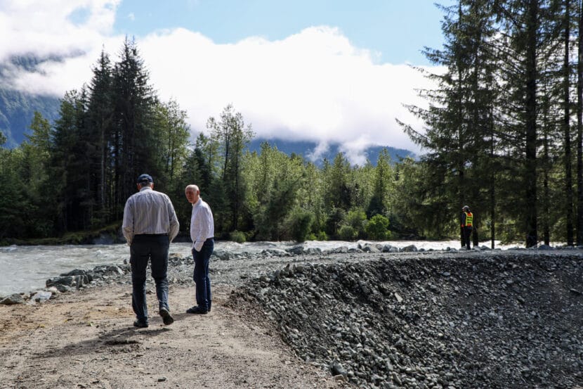
At the end of View Drive, a colossal man-made berm separates Carol and Don Habeger’s house from the cold rushing water.
Walking along the berm, they see a young spruce on the other side of the river crash into the torrent. Along with a couple of neighbors, the Habegers spent the past month erecting the levee around their home of more than 20 years. The city constructed a separate temporary levee farther downriver.
Don Habeger and Wayne Coogan walk on the top of a man-made berm built at the end of View Drive on Tuesday, Aug. 12, 2025. (Photo by Clarise Larson/KTOO)
“We are trying to save our property — we are trying to save our equity,” he said.
Imagine 400 truckloads of boulders, rocks and fine sand stacked around 12 feet high. The couple plans to stay home, even as the river is projected to reach a record-breaking level of 16.6 feet.
“I was going to invite folks, but I don’t want the liability,” he said.
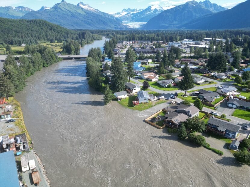
The Mendenhall River started flooding annually more than a decade ago, but for a while it was treated as more of a curiosity than a cause for concern. Then, in 2023, everything changed when a record-breaking 15-foot flood hit the Valley. A couple dozen homes flooded.
The 2024 flood broke the record again, this time cresting at 16 feet, and it was catastrophic. Nearly 300 homes flooded. The federal government declared it a major disaster.
Glacial outburst floods are not uncommon in Alaska, or in other places with glaciers around the globe. But Juneau, Alaska is the only city in the U.S. that lives beneath their threat.
Suicide Basin is the source. It’s a slurry of water, icebergs and silver silt that swells with rain and meltwater in the spring and summer.
Climate change has sharpened the risk of glacial outburst floods. In Juneau, their size has increased as the glacier has melted more rapidly. Scientists today are trying to figure out how big the floods can get.
Environmental Science Professor Eran Hood inspects a man-made berm built by residents at the end of View Drive on Tuesday, Aug. 12, 2025. (Photo by Clarise Larson/KTOO)
At a press briefing Tuesday morning, Warning Coordination Meteorologist for the National Weather Service Nicole Ferrin said the river was already unusually high because of rain from the past few days.
“This will be a new record based on all of the information that we have,” she said.
The city is encouraging residents to evacuate the area, but it’s not a mandatory order. On Monday, the city hung nearly 900 informational door flyers in Mendenhall Valley neighborhoods in the flood zone and launched a flood information hotline.
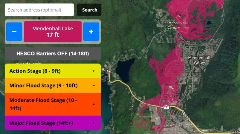
Residents can see whether their home is in the flood zoneby visiting Juneauflood.com. Though city officials say they’re confident the barriers will hold, they don’t want people to test it with their lives. The area includes homes along the river, down Riverside Drive to Safeway, past Glacier Highway and near the Juneau International Airport.
Flood maps on juneauflood.com show residents what areas of the Mendenhall Valley are expected to be impacted at different flood stages with and without the HESCO barriers. (Courtesy of City and Borough of Juneau)
Capital City Fire/Rescue Assistant Chief Sam Russell said emergency responses will become more difficult as the river rises. He asked residents to stay away from the river and bridges as much as possible.
“As the flood goes up, our ability to navigate the waters goes down due to the debris that flows down through it makes navigating the river with a boat very, very difficult,” he said.
At the Floyd Dryden campus, the American Red Cross is prepared to receive people who follow the evacuation advisory.
Loren Jones with the Red Cross heads into Floyd Dryden Campus to open an emergency evacuation shelter on Tuesday, Aug. 12, 2025. (Photo by Clarise Larson/KTOO)
Michael Downs is the Juneau district ranger for Tongass National Forest. He closed down the Forest Service campground on Mendenhall Lake this morning. The few RVs that were there are now parked at the campus.
He said the Forest Service is also managing disaster tourism in the area – people wanting to get an in-person glimpse of the flooding. He said all lakeside trails and roads by the Visitor Center and near Skater’s Cabin are closed. Anyone who violates that could face consequences.
“This year, we just did a Forest Order that they can be fined up to like, $5,000 so [it’s] got a little bit more teeth this year,” he said.
He said on top of being a safety concern, it’s to protect the employees.
“Their homes are impacted, and they work there, and people are oohing and ahhing about their disaster and it’s yucky,” he said. “I prefer people don’t come in there.”
Floodwaters are expected to peak Wednesday afternoon, and then drop through Thursday morning.
The Mendenhall Glacier dams water in Suicide Basin. As the glacier calves, it could be creating more storage space for water. That could cause bigger glacial outburst floods in the future. (Photo by Anna Canny/KTOO)
Hundreds of people in Juneau’s Mendenhall Valley are living on the front line of a climate change disaster they didn’t see coming. This is Outburst, the story of how glacial outburst flooding has escalated faster than human imagination – and public policies to protect people.
The KTOO newsroom takes you from the floodwaters to the glacier’s edge to uncover why the annual floods happen, how they got out of control and what can be done to keep Juneau safe.
Suicide Basin is a slurry of water, icebergs and silver silt between jagged peaks, and it’s the source of Juneau’s annual glacial outburst flood. The Mendenhall Glacier revealed the basin as its retreat reshapes parts of Juneau’s topography.
Researchers say that understanding the basin and others like it is key to a better knowledge of future glacial outburst floods. The second episode of Outburst takes us from the past, when early Mendenhall Valley residents were among the first record keepers of area floods, to the present to hear how scientists are figuring out how big the danger could get.
KTOO’s Alix Soliman is our guide from the basin’s edge to the Mendenhall River floodplains to understand what we know — and which questions are left unanswered.
Mendenhall River Community School next to the Mendenhall River on Wednesday, July 30, 2025. (Photo by Clarise Larson/KTOO)
Update, 3:52 p.m. Tuesday:
The Juneau School District is canceling all extracurricular and school-sponsored events Tuesday and Wednesday.
According to a district press release, this includes the first day of school for high school freshmen at Juneau-Douglas High School: Yadaa.at Kalé scheduled for tomorrow.
The district is also closing Kax̲dig̲oowu Héen Elementary School, Mendenhall River Community School and Thunder Mountain Middle School at 4 p.m. today until the City and Borough of Juneau issues an all clear. District administrators and staff are working in the buildings until the closure.
The district has not yet made a decision on closing schools on Thursday. It will make an announcement by Wednesday at noon. If any schools need to close, the district will close all campuses.
The district will continue to update families through automated calls, texts, emails, the Juneau Schools app and the district website.
Update, 10:45 a.m. Tuesday:
The Juneau School District will make a decision on closing schools by Wednesday at noon. Superintendent Frank Hauser said during a press conference Tuesday the district is requesting families update their contact information in PowerSchool to ensure they receive the most up-to-date information from the district.
Original story:
With school set to begin on Thursday, the Juneau School District announced Monday that it plans to close all schools this week if any campuses are impacted by glacial outburst flooding.
The glacial lake that releases water annually is full. That means the Mendenhall River could flood at any time this week, but it’s not clear exactly when that will happen.
Three schools in the Mendenhall Valley – Kax̲dig̲oowu Héen Elementary School, Mendenhall River Community School and Thunder Mountain Middle School – could experience flooding.
At a press conference Monday, Deputy City Manager Robert Barr said one of the reasons for closing all schools is because of district staff who may live in the flood zone.
“They have teachers, and they have staff that are in that flood inundation, that are going to be in that 17-foot impact area that we’ll be recommending an evacuation for,” he said. “From their point of view, [it’s] hard to operate the rest of the district when their faculty, when their staff, are potentially impacted.”
In an email to KTOO, Juneau School District Chief of Staff Kristin Bartlett wrote additional road congestion from school related traffic and road closures cutting off people returning home as other reasons for the plan.
In a press release, the district said it plans to announce any closures before the school day begins if possible. But it’s also prepared to evacuate schools as needed.
Students and staff will move to a safe location outside of the evacuation zone. Only guardians and emergency contacts listed in PowerSchool will be able to pick up students.
Students who take the bus and live in the evacuation zone may also be taken to a different location for pickup if they attend a school outside of the flood zone. Photo ID is required to pick up students.
The district’s website has information on flood procedures. District leadership says families can receive updates through the Juneau Schools app. The district will also email updates to families through its Blackboard communications system.
Water flows down the Mendenhall River downstream of Brotherhood Bridge, reaching into backyards along Meadow Lane. (Eric Stone/Alaska Public Media)
This is a developing story. Check back for updates.
KTOO’s livestream coverage has ended, but an archive will be available here.
Update, 1 p.m.:
During a press briefing Friday morning, members of the 2025 Juneau Glacial Lake Outburst Flood Joint Information Center provided status updates on flood recovery efforts in the Mendenhall Valley.
Juneau Mayor Beth Weldon and Central Council of the Tlingit and Haida Indian Tribes of Alaska President Chalyee Éesh Richard Peterson both shared their appreciation for local responders and relief that damage in this year’s flood was minimal compared to last year.
An official shared that debris pickup will begin Monday to allow residents more time over the weekend.
According to the city’s website, “Crews staffed by Tlingit & Haida, CBJ, and community volunteers will make a first round of debris collection from flood-impacted neighborhoods on View Drive, Marion Drive, Meander Way and Meadow Lane starting Monday, August 17 at 8 a.m. Please move your debris to the right of way for crews to pick up.”
Sabrina Grubitz, Tlingit & Haida public safety manager, shared resources for residents in need of assistance, including the recovery hotline — 1-844-445-7131 — and ready.alaska.gov where residents can apply for state individual assistance via web application. The deadline to apply is Oct. 14.
Ryan O’Shaughnessy, Juneau’s emergency manager, outlined the city’s initial damage assessment over more than 700 homes in the affected area with breakdowns based on damage level. Sixteen homes saw a relatively small amount of water in a garage or crawl space, categorized as “affected.” Another 25 homes saw a “minor” amount of damage extending into living space but not affecting electrical wiring.
Six homes saw major damage. Of those, only one was within the area protected by the city’s HESCO barrier. The rest are located on View Drive, which is not protected by the barrier.
O’Shaughnessy said there are some unverified homes that have been visually assessed from the public right of way but where city staff have not been able to contact the owners.
“It’s clear that the HESCO barrier project has saved hundreds of homes from that damage,” he said.
Nate Rumsey from the city’s Public Works department said staff are continuing to assess damage to the HESCO barrier. Several areas saw damage due to debris strikes, including a 15-foot section of the barrier by Dimond Park Field House that was most likely taken out by a tree.
South Coast Region Director for the Alaska Department of Transportation Christopher Goins said a section of the Back Loop Bridge was lost during flooding. Crews are starting work on the repair tomorrow but they do not have a timeline for when the bridge will reopen.
Update, Friday 10:30 a.m.:
The 2025 Juneau Glacial Lake Outburst Flood Joint Information Center will hold a press briefing at 11 a.m. Tune in above.
Update, 2 p.m.:
The United Way is set up in Melvin Park in the Valley from 10 a.m. to 7 p.m. Thursday and Friday to help residents impacted by flooding with requests for volunteer help with everything from pulling out wet insulation to moving sandbags. They can also provide meals.
Update, Thursday 11 a.m.:
The 2025 Juneau Glacial Lake Outburst Flood Joint Information Center held a press briefing at 10:00 a.m.
Officials said the river level has fallen to around 5 feet. Back Loop Bridge is still closed after floodwater scoured part of the bank. The Alaska Department of Transportation says the bridge will remain closed while they asses the damage.
No residents lost access to drinking water during the flood and there are no pollution concerns, according to the Alaska Department of Environmental Conservation.
Officials also shared that 30 residents of Riverview Senior Living, which sits along the Mendenhall River, were evacuated during the flood to a local church. About 20 residents stayed with local friends or family.
As the damage assessment becomes more clear, local officials will provide more information on individual assistance on Friday.
Update, 3 p.m.:
Emergency officials issued an alert that the flood threat has ended and evacuated areas are now open to residents only.
Back Loop Bridge remains closed, but power has been restored to most of the affected area.
The river level has receded to minor flood stage.
Update, 10:15 a.m.:
The flood zone remains under an evacuation advisory, but Capital City Fire/Rescue Assistant Chief Sam Russell said during a press conference that emergency responders did not need to make any rescues overnight as waters levels rose.
Ryan O’Shaughnessy, Juneau’s emergency manager, says AEL&P is starting to restore power to affected areas. He also said officials are continuing to assess the HESCO barriers. City officials say the barriers protected homes that would have otherwise been more severely damaged by record-breaking flood levels, even though some flooding still occurred. Damage is still being assessed.
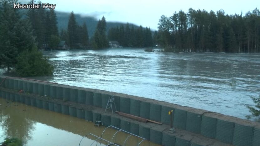
KTOO’s Clarise Larson shot this footage from Meander Way this morning.
Update, 9:30 a.m.:
The water level continues to drop on Mendenhall Lake and River. The current gauge level is 14.5, which means we remain in major flood stage. The National Weather Service says water is receding quickly and should reach minor flood stage later this afternoon.
Once again, the 2025 Juneau Glacial Lake Outburst Flood Joint Information Center will hold a press briefing at 10:00 a.m. KTOO will carry the briefing live on 360TV, on the radio and here via the livestream.
Update, 8:00 a.m.:
The National Weather Service has confirmed that the river crested at 16.65 feet a short while ago and water levels are now dropping.
The 2025 Juneau Glacial Lake Outburst Flood Joint Information Center will hold a press briefing at 10:00 a.m. KTOO will carry the briefing live on 360TV, on the radio and via livestream.
“Today’s briefing will provide an update on the status of the flooding, actions taken by the Unified Command over the last 24 hours, as well as overview of planned next steps,” the media release states.
Update, 7:15 a.m.:
The City and Borough of Juneau wants residents to avoid driving on flooded streets.
The flood barriers continue to hold, but water is being observed seeping around them.
Onlookers watch as water seeps through a HESCO barrier on Riverside Drive near Melvin Park. (Eric Stone/Alaska Public Media)
Update, 6:30 a.m.:
AEL&P has cut power to parts of the Mendenhall Valley as flood waters continue to rise.
Update, 6:00 a.m. Wednesday:
The sun is up over the Mendenhall Valley as the water level on Mendenhall River currently stands above 16 feet — a new record for glacial outburst flood height in Juneau.
The river reached major flood stage around 1 a.m. and is still forecast to peak later this morning between 8 a.m. and noon. There are reports of water seeping under the temporary levee and water on some streets in the Valley.
Send any observations or pictures you’d like to share from your neighborhood to news@ktoo.org.
A KTOO webcam image shows water seeping below HESCO barriers along Meander Way shortly after 6 a.m. on Wednesday, Aug. 13, 2025. (Screengrab)
Update, 7:00 p.m. Tuesday:
The National Weather Service has updated its forecast for when the glacial outburst flood will crest. As of this evening, a crest somewhere between 16.25 and 16.75 feet is expected between 8 a.m. and noon Wednesday.
The initial flood forecast estimated a peak of around 16.6 feet on Wednesday afternoon.
Water levels are expected to go above major flood stage of 14 feet early Wednesday morning.
The district is also closing Kax̲dig̲oowu Héen Elementary School, Mendenhall River Community School and Thunder Mountain Middle School at 4 p.m. today until the City and Borough of Juneau issues an all clear.
The district has not yet made a decision on closing schools on Thursday — the first day of school. It will make an announcement by Wednesday at noon. If any schools need to close, the district will close all campuses.
Update, 11:10 a.m. Tuesday:
During an 10 a.m. press conference, local officials shared public safety updates.
Nicole Ferrin, the warning coordination meteorologist at the National Weather Service in Juneau, said the record peak of 16.6 feet is expected sometime Wednesday afternoon.
“This will be a new record based on all of the information that we have,” she said.
Ryan O’Shaughnessy, Juneau’s emergency manager, asked residents to stay away from the river and bridges. Backloop Bridge will close at 8:30 p.m. Tuesday.
“This is a very dangerous situation,” he said.
On Monday, the city hung nearly 900 informational door flyers in Mendenhall Valley neighborhoods in the flood zone and launched a flood information hotline.
“There’s no need to rush out of neighborhoods, but we encourage folks to take a moment, take a deep breath, and remember that they have a plan,” O’Shaughnessy said. “This is something that we’ve been planning for as a community.”
Capital City Fire/Rescue Assistant Chief Sam Russell said emergency responses will become more difficult as the river rises.
“As the flood goes up, our ability to navigate the waters goes down due to the debris that flows down through it makes navigating the river with a boat very, very difficult,” Russell said. “Please stay away from the river as much as possible.”
Update, 10:45 a.m. Tuesday:
The Juneau School District will make a decision on closing schools by Wednesday at noon. The district plans to close all schools if any campuses will be impacted by flooding.
Superintendent Frank Hauser said during a press conference Tuesday the district is requesting families update contact information in PowerSchool to ensure they receive the most recent updates from the district.
Update, 9:45 a.m. Tuesday:
Juneau’s glacial outburst flood has begun.
Just before 9:30 a.m. on Tuesday, the National Weather Service issued a flood warning and initial flood forecast of around 16.6 feet for Mendenhall River. That record peak is expected Wednesday afternoon.
This comes as the river is already in a minor flood stage due to significant rainfall over the past few days. The weather is expected to be dry Tuesday afternoon and Wednesday.
The forecast is subject to change. Typically it takes a day for the National Weather Service to see how fast the water is moving and adjust the forecast accordingly.
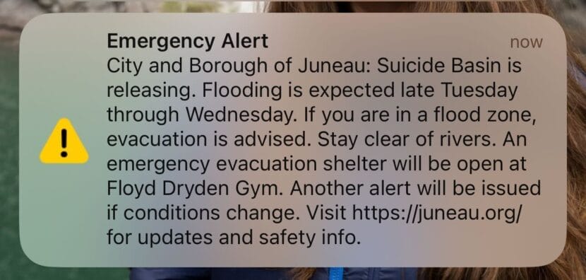
The City and Borough of Juneau issued an emergency alert via text that told residents in the flood zone that “evacuation is advised. Stay clear of rivers.”
An emergency alert sent to Juneau residents on Tuesday morning, Aug. 12, 2025. (Courtesy of Eric Stone)
An emergency evacuation shelter will be at Floyd Dryden Middle School later on Tuesday.
Update, 2:30 p.m. Monday:
City and tribal officials say they will begin hanging informational door flyers in Mendenhall Valley neighborhoods in the flood zone and launch a flood information hotline Monday afternoon.
The door hangars warn residents that the basin is full and that an emergency shelter will be available at Floyd Dryden Middle School once the flood begins. It also includes advice on how to protect property.
Aaron Jacobs, the senior service hydrologist at the National Weather Service in Juneau, gave an update on Suicide Basin at a press briefing late Monday morning. Suicide Basin reached full capacity and began spilling over the top of the glacier Sunday night.
“At this time there is no signs that the release has taken place,” he said.
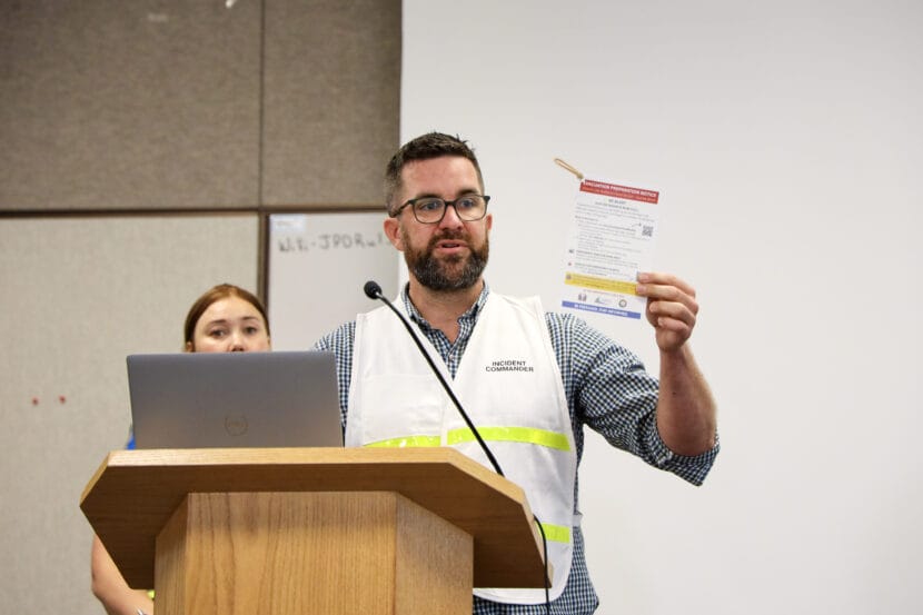
Ryan O’Shaughnessy, Juneau’s emergency manager, displays a flood informational door hangar at a press briefing on Monday, Aug. 11, 2025. (Photo by Clarise Larson/KTOO)
He said Monday’s rainfall will likely continue to raise water levels in Mendenhall River and Lake, which could affect the flood height once water does start releasing. But, he expects the precipitation to slowly drop off through Monday evening and into Tuesday.
“I know there’s been some reports of a waterfall being seen at the face of the glacier, and that is what we’re seeing. There is just a general glacial flow in the runoff that we’re seeing from the precipitation and just the regular melt from the Mendenhall Glacier,” he said.
Ryan O’Shaughnessy, Juneau’s emergency manager, said the city continues to advise people to prepare to evacuate. They have not issued a mandatory evacuation order, but officials highly recommend people leave once the flood warning is issued. This year’s flood will be the first test of the flood barrier the city installed this spring.
“We have a lot of confidence in the mitigation measures that have been put in place — that being said, this is not something that we want to gamble with,” he said. “The message to carry across please, is to ‘Yes, evacuate if you do get that notice.’”
The state’s Department of Transportation & Public Facilities is preparing for potential bridge and road closures along the river. Officials say when and where will depend on the height and timing of the flood.
Original story:
The countdown has begun for Juneau’s annual Glacial Lake Outburst Flood. Suicide Basin reached full capacity and began spilling over the top of the glacier Sunday night.
That means flooding could begin any day.
The National Weather Service issued a special weather statement indicating that it could take up to six days for the basin to release floodwaters into Mendenhall Lake.
Once the water level in Mendenhall Lake begins to rise, the National Weather Service will issue a flood warning. From that point, it will take about 48 hours for the floodwaters to crest in the Mendenhall River.
The City and Borough of Juneau issued an emergency text alert just after 8 p.m. that notified Juneau residents that the basin was overtopping.
“Now is the time to make last-minute preparations, finalize evacuation plans, and pack a go-bag,” the alert stated.
Aaron Jacobs, the senior service hydrologist at the National Weather Service in Juneau, said that the contingency forecast is a 16.5-foot flood — that’s subject to change. Jacobs said to check the Suicide Basin monitoring page for an updated forecast once the release begins and as it progresses.
The contingency forecast is based on estimates that Suicide Basin has expanded compared to prior years and that the ice dam holding back the water is a bit lower.
That forecast is also based on the past few days of increased rainfall, which have raised the water levels in the lake and river. Jacobs said the rain could affect the flood height if it doesn’t flow out to sea before the basin releases.
“So we’re hoping that the basin will not release at this time in the next day or so and then the Mendenhall levels can come back down to more normal levels,” he said.
The city will issue another emergency text alert when the National Weather Service issues a Flood Warning. That will mean that the basin is releasing and the flood has begun.