Weather

Geologists investigating Ketchikan landslide causes, after four fatal Alaska slides in a decade

A deadly landslide in Ketchikan on Sunday, Aug. 25, 2024, seen on the Ketchikan Gateway Borough’s website. (Ketchikan Gateway Borough)

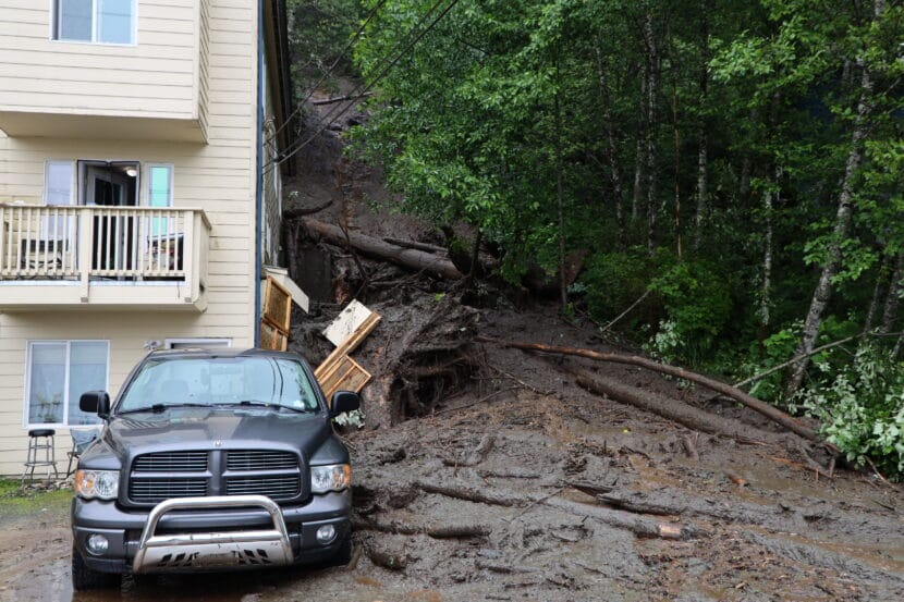
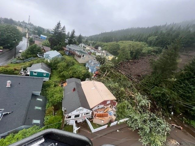
Landslides like the one that killed a man in Ketchikan on Sunday can strike with little warning, sending earth and trees crashing down a mountainside as fast as a car on a highway.

Scientists are still looking into what factors were at play in the deadly Ketchikan landslide, but rainfall saturating the ground, potentially triggered by wind, are common culprits in landslides in Southeast Alaska. There’s also the increased frequency and severity of weather events associated with climate change.

Dr. Gabriel Wolken is manager of the Climate and Cryosphere Hazards Program for the state Division of Geological and Geophysical Surveys. Wolken says landslides are often the result of a complicated series of events.

This interview has been lightly edited for length and clarity.

Gabriel Wolken: Several factors contribute to the development of a landslide, and then triggering is something else, too. Saturated ground can elevate landslide susceptibility, and this causes a reduction in the stresses that hold the soil particles together, the rock together, just inserting water in between different soil particles, and it causes those particles to separate, no longer interlock. And so that’s typically what happens during precipitation events, especially extreme precipitation events, when there is a lot of moisture falling to the ground. And this is especially the case when soils are already saturated.

And then several factors contribute to the development of landslides. You know, rainfall, snowfall, temperature changes, and of course, wind is one of those. Typically, wind’s influence on the development of landslides has to do with the wind’s impact on trees, and then how the tree acts as a lever on the soil,and the different physical interactions that happen at that point.

I just want to underscore that we really don’t know enough about the landslides in Ketchikan to make any sort of statements about the causes, the triggers, at this point, but we’re really investigating it right now. We have many of our folks, partners on the ground, investigating the landslide right now, assessing it, assessing the stability of the slope, and then later, you know, we’ll really dive into trying to understand what actually happened.

Casey Grove: Yeah, that makes sense. So I wanted to ask you about something that has come up. I think it’s been four fatal landslides in the last 10 years or so. And, you know, folks are talking about how it seems like these are happening more frequently. Is that true? And do we have any kind of sense of why that might be?

GW: Yeah, I mean, it does. It does seem that way. I agree, 12 fatalities in the last decade or so is a lot, and this is hard to deal with. And, you know, our thoughts go out to the people who are impacted by these disastrous events. But in terms of determining whether or not landslides in Alaska are occurring more frequently in recent decades or in recent time compared to those in the past, is really quite difficult, if not impossible, to answer at this time, really due to a few factors. And really the most influential, perhaps, is the inconsistencies in landslide reporting. And so it means that we really don’t have a detailed enough historical record in Alaska, the records really don’t go back far enough for us, to be able to fully assess whether or not there has been an increase in landslides in recent time.

CG: Hypothetically, I mean, seeing the effects of climate change on so many different parts of our lives and so many different parts of the terrain out there, would you expect that that could be something that would increase, maybe, the frequency of landslides?

GW: Right, yeah, so again, the caveat is always (that) Alaska is fairly data sparse, and so it’s really hard to answer this question directly. But what is clear is that as the world warms, climate change is making adverse and extreme weather events both more likely and worse.

And so while these areas, such as Southeast Alaska, are already quite damp and windy at times, increases in temperature, precipitation and wind likely will have noticeable effect on the landscape, and that could include a change to what we consider to be the frequency and magnitude of natural hazards right now. And so in other places in the world, there have been connections to increases in the frequency of landslides with increasing temperature and precipitation. That’s entirely likely for Alaska, but we cannot say definitively that that’s that’s indeed the case at this point.

CG: So I appreciate you being the one to step forward and talk to me about this today, and I don’t mean to put this huge question just on you alone, but what are we supposed to do about that? I mean, what can local, state, federal agencies do? What sort of things are underway, maybe already, to help people avoid the adverse impacts of of landslides?

GW: Right, well, I think what’s really important is that we have very good relationships going on right now between state, federal agencies, local government agencies, universities, all really good relationships. We have partnerships in play, and the goal really is to try to work together to make sure that we’re doing all we can with what we have to provide a resilient state, resilient communities, by increasing the knowledge of the conditions that create landslides and to try to just generally make things safer for people.

And what this ends up being is a very challenging area to work, and we cannot with absolute certainty, you know, provide predictions about landslides, or anything even remotely close to that. But what we can do is evaluate landslides that have happened. We can make sure that we’re recording landslides and specific events properly so that we can use that to increase our knowledge and hopefully predict how landslides might occur in the future.

Bering Sea storm brings erosion and flooding to Western Alaska communities

Severe flooding is seen in the coastal community of Kwigillingok on the morning of Sunday, Aug. 18, 2024. (Courtesy Lewis Martin)

A series of large storms have left some Western Alaska communities grappling with flooding and erosion. Some residents report that the flooding is worse than Typhoon Merbok, and that it rivals this year’s historic breakup floods on the Kuskokwim River.

In Tuntutuliak, on the lower Kuskokwim, a community member reported to the National Weather Service that at least two houses had been inundated with water.

In Napakiak, already-rapid erosion marching toward the community’s school has reportedly come within 6 feet of the gym, creating safety concerns for the building. According to Napakiak resident Bethany Hale, water levels began rising rapidly around 1 p.m. on Aug. 18, but appeared to be receding as of that evening.

A drone image shows floodwaters threatening the William Miller Memorial School in Napakiak on Sunday, Aug, 18, 2024. (Courtesy Job Hale)

Upriver in Akiak, community members have reported riverbank erosion of between 10 and 20 feet due to the storm, along with swamped boats and lost fishing nets.

In Bethel, the city government closed the south boat harbor and East Avenue because of flooding. As of the evening of Aug. 18, the Kuskokwim River gauge at Brown’s Slough recorded a level of 9.52 feet, well into the minor flooding stage.

Earlier that afternoon, Bethel Search and Rescue reported water over the roadway at multiple locations along the Bethel riverfront and wind gusts of up to 50 miles per hour.

According to Christian Landry, a meteorologist with the National Weather Service in Anchorage, strong onshore winds have been holding an already swollen Kuskokwim River in place.

“The river wants to pour out and exit into the Bering Sea. It’s having trouble doing that with all of the wave action, and the winds, and all of the new rainfall dropping into the river, so it’s swelling beyond capacity,” Landry said.

The National Weather Service has extended a flood warning for Kuskokwim River communities to include Tuntutuliak and the tundra villages of Kasigluk, Nunapitchuk, and Atmautluak, effective through 6 p.m. on Aug. 19.

A coastal flood advisory for the Kuskokwim Delta was lifted on the evening of Aug. 18. Images posted on social media just hours before showed widespread inundation in Kipnuk and Kwigillingok, where one resident said that the flooding was the worst in more than three decades.

The rain, flooding, and erosion have been caused by the second in a series of storms to hit Southwest Alaska in the past week. The first weather system off the Bering Sea began blasting the region on Aug. 15, tapering off before the weekend.

Earlier this week, a National Weather Service meteorologist said that he believed that the impact of the high winds and surf from the second storm were made more severe by the rare super blue moon that will peak on Aug. 19. According to Landry, meteorologists are still unsure what the impacts will look like for a third storm forecast to hit the region, considered to be the remnants of Typhoon Ampil.

“It appears that this system is going to push mostly to the north of the area. It will bring potentially another round of rain by late [Aug. 20] after noon. However, how potent that wave will be is not entirely certain,” Landry said.

The National Weather Service advises all residents to secure belongings, move items inland when possible, and to be alert and prepared to take action.

Visit the Alaska-Pacific River Forecast Center website for the latest flood advisory updates, or call the 24-hour toll-free Alaska Weather Information Line at 855-937-4977.

Smoke from Canada wildfires tinges the sky over parts of Southeast Alaska

Smoke slightly obscures the view of the Coastal Mountains, including Devils Thumb, from Hungry Point in Petersburg on Aug. 6, 2024. (Photo by Shelby Herbert/KFSK)

Southeast Alaska has almost a full week of sunshine ahead, but those blue skies will be slightly dingy with smoke from wildfires in Canada.

Numerous fires are burning across British Columbia, the Northwest Territories, the Yukon and even as far away as Alberta. And they’re producing just enough smoke to start hazing up the skies in the panhandle — especially in the southern half, which contains Petersburg, Wrangell, and Ketchikan.

But Brian Bezenek, the lead meteorologist with the National Weather Service in Juneau, says it’s nothing for Southeast Alaskans to worry about. A slight haze may be the worst of it — at least for now.

“If it persists for a long time, it may become an issue,” says Bezenek. “But right now, I think it’s more of just a high, thin layer of smoke coming in. Mainly what you’re seeing is the high particles — and unless you’re smelling the smoke, you’re probably not seeing a whole lot at the lower levels.

That’s all to say that Bezenek doesn’t expect that the smoke will affect air travel or inconvenience people in vulnerable groups — like the elderly, children, or those with certain medical conditions.

He says it’s still possible that Southeast Alaskans might get to enjoy a few smokeless and cloudless skies before the rains return. Bezenek predicts that the wave of smoke should abate after a big low pushes it out of the way before the weekend.

Rainfall will intensify Monday night after a wet weekend in Southeast Alaska

A man attempts to clear a drain in the parking lot of the Four Points by Sheraton Juneau on Monday, July 15, 2024. (Clarise Larson/KTOO)

The wet weather that drenched much of Southeast Alaska over the weekend is expected to persist through tomorrow morning. Rainfall will be especially intense this evening in Juneau, Skagway, Haines Gustavus, Hoonah and Tenakee Springs.

“That is when we’re expecting the last batch of heaviest rain to really push through the area,” said meteorologist Sean Jones, with the National Weather Service Office in Juneau.

Heavy rainfall has saturated the ground, elevating the risk of landslides, and rivers and creeks are rising, especially in the northern panhandle. 

The National Weather Service has issued a flood advisory for the Mendenhall Valley in Juneau, especially Auke Lake and Jordan Creek, effective through 10 am Tuesday morning. 

A flood advisory is also in effect for the Chilkat River, as snowmelt and runoff push water levels in the basin higher. 

Jones says this amount of rainfall is pretty typical during Southeast Alaska’s rainy season, which usually begins in the fall. But it comes after a stretch of rain last week, when multiple single day rainfall records were broken across the region.

“Also, this was a long duration event, where we had significant rain totals over multiple days,” Jones said. “So that is part of the reason that it’s more impactful.”

Between 3 and 8 inches of rain has already fallen, and the forecast calls for 1 to 2 more inches before the storm lightens up  on Tuesday morning.

By Tuesday evening, moderate to heavy rainfall may start up again, when an incoming wet front stalls over the central panhandle between Wrangell and Juneau. That could drop an additional 2 to 4 inches of rain on soil that’s already saturated, especially around Juneau and Petersburg.  

Downtown Juneau apartment building evacuated following landslide

A landslide on Gastineau Avenue in Juneau, Alaska on Sunday, July 14, 2024. (Clarise Larson/KTOO)

A landslide on Gastineau Avenue late Sunday morning displaced at least seven people in the Strasbaugh Apartments building. 

According to Tom Mattice, the city’s Emergency Programs Manager, no injuries or major damage to the building has been reported, but city officials recommended residents evacuate as a precaution. 

Heavy rain triggered the slide, which brought down some trees, large debris and mud onto the road. Mattice said two more slides have also occurred in downtown Juneau as of Sunday afternoon, and more are likely as the rain continues. 

“We could definitely see more events over the next couple of days,” he said. “People who live in the affected areas should be thinking about their safety, and if they choose to self evacuate or spend the night at a friend’s house, it’s never a bad idea.”

The National Weather Service Juneau has issued a flood watch through Monday evening, and significant rainfall is expected through Tuesday. 

Police block car traffic on Gastineau Avenue after a landslide in Juneau, Alaska on Sunday, July 14, 2024. (Clarise Larson/KTOO)

“The bottom line is, is if you’re at the base of a big hill, you’re going to see a lot of water coming off that hill. And sooner or later, you may see mud with it,” Mattice said.

City Manager Katie Koester said the city is not evacuating any more people at the moment. 

“This is the beginning of a three-day rain event, so it’s going to get wetter,” she said. “If people have somewhere else safe to stay for the night or a couple, might not be a bad idea. But that’s a personal decision right now.”

Gastineau Avenue was the site of another landslide that displaced residents and heavily damaged a home in September 2022.

According to Deputy City Manager Robert Barr, evacuations for residents of the Strasbaugh Apartments have been voluntary so far per recommendations from the city. The Red Cross is assisting displaced residents. 

This is a breaking story. Check back for updates. 

Denali National Park bars visitors as wildfire burns near entrance

Smokejumpers parachute into position to fight the Riley Fire near Denali National Park and Preserve’s entrance on Sunday, June 30, 2024. (From Bradley Hagstrom/National Park Service)

Denali National Park and Preserve has largely shut down operations because of a wildfire near the park entrance.

Park spokesperson Paul Ollig said the Riley Fire was reported early Sunday afternoon, directly across the Nenana River from the McKinley Chalet and Glitter Gulch.

“All of the public facilities in Denali’s front country are closed and will remain closed until further notice,” Ollig said.

Ollig said the fire burned quickly through black spruce.

“By about 6 in the evening we estimated it was about 350 to 400 acres,” he said.

The Riley Fire is being worked intensely by ground crews as well as helicopters and planes, according to Alaska Fire Service spokesperson Beth Ipsen.

“They were basically just doing runs, just going back and forth on this fire, dropping water, dropping retardant,” Ipsen said.

According to Ipsen, four hotshot crews arriving from the Lower 48 Monday will deploy on the Riley Fire. She said the goal is to herd the flames out of black spruce into higher terrain to the northwest — away from Alaska Railroad tracks, the Nenana River, the Parks Highway and the park entrance.

“There’s a lot of buildings, structures. There’s a lot of businesses,” Ipsen said.

A Denali Borough evacuation notice posted Sunday for people near the Riley Fire. (From Denali Borough)

The Park Service’s Ollig said the agency has taken precautions, including relocating approximately 150 employees from entrance-area housing, and evacuating the nearby Riley Creek Campground. No one is currently being allowed into the park, and the only transportation service is a shuttle to pick up hikers already in the backcountry.

“This is the busiest time of the year in the park, with the highest number of visitors, so the impacts are significant,” he said.

Ollig said visitors already at campgrounds west of the park entrance were allowed to stay Sunday, but that could change depending on fire activity. He said that the cause of the Riley Fire has not been determined, and noted that its timing falls on a major wildfire anniversary.

“We are almost at one hundred years to the day that the 1924 fire swept through this area,” Ollig said.

Ollig said there had not been another significant wildfire in the park entrance area until now.

Site notifications
Update notification options
Subscribe to notifications