Weather

Kotzebue airport reopens as flood damage assessments and cleanup continue

Rescue workers carry children after Tuesday’s flooding in Kotzebue. (From Northwest Arctic Borough Facebook page)

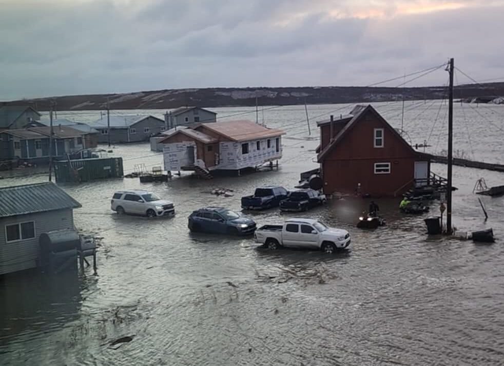
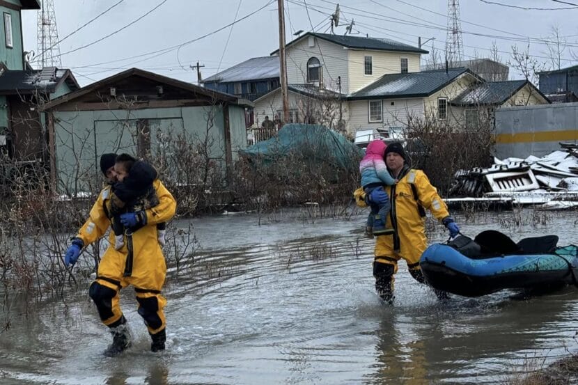
Recovery efforts continued Thursday in Kotzebue, after a storm and severe flooding Tuesday night destroyed buildings and forced 80 residents to evacuate their homes. Emergency responders are trying to assess the damage as winter quickly closes in.

“I think a lot of the debris, what we are seeing, they don’t even know whose it is, whose stuff it is in their yard, because things are floating around,” said Paulette Schuerch, who works with the Native village of Kotzebue. The tribe has been working with the state, borough and city on the emergency and cleanup response.

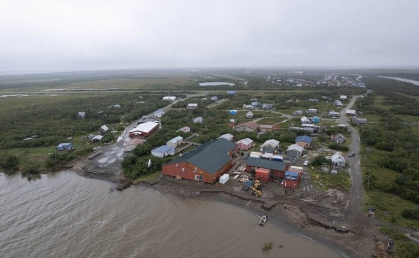
Officials said the flooding destroyed Kotzebue’s dock, several roads and bridges and dozens of structures at multiple subsistence camps. The force of the storm also transported four large dumpsters to a sandbar in Kotzebue’s lagoon.

City officials said two homes were also destroyed, displacing a family of six and a disabled elder. The family sheltered at Kotzebue’s school Wednesday night, and the elder stayed at the Nullaġvik Hotel. Coordinated efforts are underway between the city, Kotzebue’s tribe and local churches to secure long-term housing, supplies and food for the affected residents.

Schuerch said although 80 people evacuated to shelter on Tuesday, a lot more people may have left their homes to stay with family or friends. Many more residents’ homes were damaged. She said while many homes are still standing, they may have unstable foundations, damaged insulation, or other repairs that could cause serious safety issues as winter quickly approaches.

“All the insulation and floorboards really need to be an immediate resolution, because they’re going to freeze,” she said.

The City of Kotzebue is encouraging residents to document storm damage and to submit it to their planning department. It’s required for individuals to receive disaster assistance.

City officials said portions of Kotzebue’s sewer lagoon were also impacted, but need to further assess the damage.

Ten members of the Alaska National Guard are expected to arrive on Friday.

“The airfield is open right now, recently open, but it wasn’t for a couple of days,” said Alan Brown, a guard spokesperson. “Our ability to get there – logistics takes so much more energy and time, and it’s much more complicated the further out you are.”

Kotzebue’s airport opened Wednesday night for limited flights after being closed for more than 48 hours. Representatives from Maniilaq Health Center said an emergency flight coordinated with Alaska State Troopers and the Red Dog Mine was able to deliver critical medication to Point Hope on Wednesday while most planes were unable to fly.

Airport officials said the runway and weather equipment necessary for airline travel was damaged by the flood. The access road to the airport also experienced significant damage. Brown said those things can make a big difference.

“Something happens in rural Alaska of this degree, logistics becomes a real factor, whether or not, you know, we can get supplies in,” he said. “That takes a lot more time.”

State officials and the Alaska chapter of the Red Cross are set to arrive in Kotzebue within the next few days. Officials said more emergency supplies like bottled water, dehumidifiers, fans and building materials will hopefully come in soon.

Gov. Mike Dunleavy declared a state disaster on Tuesday.

Kotzebue flooding declared state disaster as residents recover

Flooding near Kotzebue’s lagoon on Oct. 22, 2024. (Courtesy Micheal Andrew Gudmundson)

The Northwest Arctic community of Kotzebue is starting recovery efforts after a coastal storm caused widespread flooding in the town of over 3,000 people. Gov. Mike Dunleavy issued a disaster declaration Tuesday in response, and emergency efforts are continuing as multiple organizations assess the damage.

Residents began evacuating their homes on Tuesday afternoon as rising water levels threatened numerous structures. Over 80 residents evacuated their homes on Tuesday night. Residents were evacuated by the city’s ambulances, with some people riding in the buckets of bulldozers.

The majority of displaced residents stayed in Kotzebue’s high school gym, and others at the hospital, hotel, businesses or with relatives. The borough and a local restaurant, Little Louie’s, provided pizza and breakfast in the morning.

Representatives from a multi-agency emergency response team say at least one home has collapsed into Kotzebue Sound because of the flooding. Officials say multiple homes may also be too damaged to live in, as winter quickly approaches.

Dozens of tents at a seasonal fish camp on Kotzebue’s northside of town have completely washed away and at least one sled dog team has also been displaced. The city says seasonal structures around the Swan Lake dock have also washed away.

Kotzebue schools and numerous businesses remained closed on Wednesday. The town’s airport runways closed on Tuesday due to excessive ice and winds. Flights were scheduled as of noon on Wednesday – although it was unclear if those planes would be able to land. Photos circulating on social media show Alaska Airlines’ terminal flooded.

Emergency officials are encouraging residents to take photos and save receipts in order to document the damages.

Several other communities have also experienced flooding because of the storm, including the coastal communities of Deering and Shishmaref.

Fall storm brings rain and significant wind to Southeast

Rain runoff runs down a drain in the Mendenhall Valley in November 2022. (Clarise Larson/ for the Juneau Empire)

A strong fall storm will move across the Gulf of Alaska Friday afternoon, bringing heavy rain and strong winds to Southeast communities through Saturday. 

The front originates from a low pressure system that’s currently hanging over the western gulf near Kodiak. It’s already battering the island community with gusts of up to 75 miles per hour. 

National Weather Service Meteorologist Grant Smith said the storm is headed toward Southeast Alaska now. It’ll hit outer coast communities from Yakutat to Prince of Wales Island first, before spreading inland.

“It’s just a front moving essentially from west to east,” he said. “So we’ll start seeing the winds and rain along the coast, beginning this evening. And then once you get into the overnight and the weekend, that’s when the rest of the Panhandle will see the rain.”

Most places can expect rainfall totals between two and three inches at sea level, though there could be more rain on mountain slopes. 

“The moisture amounts are not really all that impressive for Southeast Alaska,” he said. “The strongest winds are going to happen when the front moves through tonight into early tomorrow.”

Communities including Petersburg, Wrangell, Juneau, Hoonah, Gustavus and Yakutat could see wind speeds between 30 and 50 miles per hour as the storm passes through.

Further south, winds could be even stronger, with gusts of up to 60 miles per hour. A high wind warning is in effect from 1 a.m. to 10 a.m. Saturday for Sitka, Craig, Klawock, and Hydaburg. Ketchikan and Metlakatla are under a high wind warning effective from 4 a.m. through 1 p.m. Saturday.

Winds that strong can blow down trees and powerlines, causing property damage and the potential for widespread power outages. 

People are encouraged to secure their vessels or any other loose objects that could be blown around or damaged by the winds

Storm blowing into Southeast halts some cruise ships in Juneau

Visitors brave the rain as they head back to their cruise ships in Juneau on Monday, Sept. 30, 2024. (Clarise Larson/KTOO)

A storm moving through Southeast Alaska is causing high winds and waves for the outer coast and inner channels Monday and will continue into Tuesday. That’s causing at least one cruise line to cancel some port calls in the region. 

Meteorologist Nathan Compton with the National Weather Service Office in Juneau says waves of 5 to 6 feet were expected in inner channels like Icy Strait and Stevens Passage near Juneau as wind speeds increased Monday. 

“We’re currently already seeing storm force winds with occasional dust up to hurricane force in particular, Cape Decision has seen gusts up to 67 knots, which is very, very high,” Compton said. 

Cruise Line Agencies of Alaska confirmed that Holland America Line decided to keep its Eurodam and Koningsdam cruise ships ported in Juneau overnight and into Tuesday evening. Both ships have capacities of more than 2,000 passengers.

The Norwegian Bliss also arrived in port Monday. As of the afternoon, it was still scheduled to leave later in the evening. 

High Wind Warnings are in effect for the southern panhandle and Baranof Island. 

Compton says rain will be heavy at times Monday night into Tuesday, but it’s not expected to cause major hazards. 

“It’s not the typical atmospheric river that would cause any sort of flooding concerns,” he said. 

Wind and rain will continue Tuesday before decreasing Wednesday.

Wet Labor Day weekend kicks off Southeast rainy season

Rain runoff runs down a drain in the Mendenhall Valley in November 2022. (Clarise Larson/ for the Juneau Empire)

Heavy rainfall is coming to Southeast Alaska this weekend, beginning Friday afternoon.

This kind of precipitation can increase the risk of landslides. In a public service announcement, the City and Borough of Juneau advised residents on and around slopes to be aware of their surroundings as the wet weather moves through.

Meteorologist Pete Boyd with the National Weather Service said the storm is moving in from the Gulf of Alaska.

“It’s a long fetch of moisture coming up from the Pacific — an atmospheric river — so that’s going to be feeding in heavy precipitation to the area,” he said.

To the south, Ketchikan, Metlakatla and surrounding communities can expect between two and four inches of rain. 

The central panhandle, between Sumner Strait and Frederick Sound, is where the main swath of precipitation will be focused. Places like Kake, Petersburg, Wrangell and the northern portion of Prince of Wales Island, will be the most drenched. The forecast calls for three to five inches of rain at sea level in those communities, with the potential for up to seven inches at higher elevations.

Sitka is at the northern edge of the front, and could see that heavy rain too as the storm progresses. Further north, Juneau, Angoon, Hoonah and Gustavus can expect between two and five inches of rain, but Haines and Skagway will likely see just one to two inches. 

Boyd says people should prepare for the weekend accordingly. 

“Mariners always check your boats bilge pumps, making sure those are working, keeping an eye on it for people around their homes, check your sump pumps. Check your gutter,” he said. “And any sewer grades around the area. Those are always great to make sure that, especially in the area that they’re clear.”

Despite the rain, no flooding is expected at this time. The most intense rainfall will begin on Friday evening and continue through Saturday afternoon. Rain is expected to lighten up after that but it will remain wet through Sunday, and the forecast calls for more showers throughout next week.

“We’re now just going to see them coming more and more throughout the week,” he said. “So yep, the rainy season is going to be starting up.”

Yukon-Kuskokwim Delta residents brace for fall storms after early floods and erosion

On average, Napakiak residents see about 30 feet of the Kuskokwim River’s bank erode every year. (Gabby Salgado/KYUK)

A series of very strong storms caught many people in Western Alaska off guard last week, including in Napakiak, where the banks of the Kuskokwim River are eroding at a startling rate.

The community was inundated with floodwaters from the Kuskokwim for two days. Signs of the flooding are evident everywhere: snow machines and four-wheelers were still parked on high ground days later. And a crew had to repair the plumbing under the city office after high water damaged pipes.

“Everything was displaced,” said Walter Nelson, as he pointed to where floodwaters from the Kuskokwim, which is also influenced by tides on the Bering Sea coast, rose to about his midsection. He said he’s used to these kinds of events.

“Even if we don’t have a plan for it, there’s ways around it, and that we can tackle it and that’s what we’ve been doing and hope to continue doing,” he said.

In 2020, Nelson, who works for the city, helped devise Napakiak’s 50-year plan. It outlines how the community will retreat from severe erosion along the Kuskokwim River’s edge, which is about a quarter mile from the city office.

Nelson pointed to chunks of broken riverbank, where the sand, mud and gravel disappeared into the silty, grayish-brown water during this most recent series of storms. “It just cracks underneath at high tide, waves just bang this way,” he explained.

This is all happening about 10 feet from the back end of Napakiak’s public school.

“Every year we hold community gatherings for the whole community, meeting place, basketball games, what not, potlucks, potlatches, a lot of good memories are going to be gone …” Nelson said.

Roughly half the school building was demolished last year. A crew is racing to take down the rest of the building this fall before it collapses into the river.

According to climatologist Rick Thoman, these kinds of storms aren’t unprecedented, but they don’t usually arrive on the Yukon Kuskokwim Delta until later in the fall.

“It was a deep low pressure center by late August standards but not at record level,” Thoman wrote in an email.

He said that Bristol Bay saw severe coastal flooding in August in 2005. Back in 1990, Nome also experienced severe weather and saw significant coastal erosion.

On average, Napakiak sees up to 30 feet of riverbank disappear every year. Major storm systems can accelerate that pace, and Nelson, who is 64 and grew up in Napakiak, said he just hasn’t seen this kind of weather in August.

“September is actually where most of the southern and western storms come in. Everything is gonna accelerate, I just know it is,” he said. “But we cannot fight Mother Nature, just be prepared for her.”

Nelsons said the impacts from the remnants of Typhoon Merbok back in September 2022 are still the worst he’s ever seen, but the damage from this most recent storm system is a close comparison – perhaps a little too close for comfort.

Site notifications
Update notification options
Subscribe to notifications