Weather

Elliott Highway closed as the number of wildfires burning in Alaska grows

An aerial view of the Globe Fire on the afternoon of Thursday, June 27, 2024. (From Alaska Fire Service)

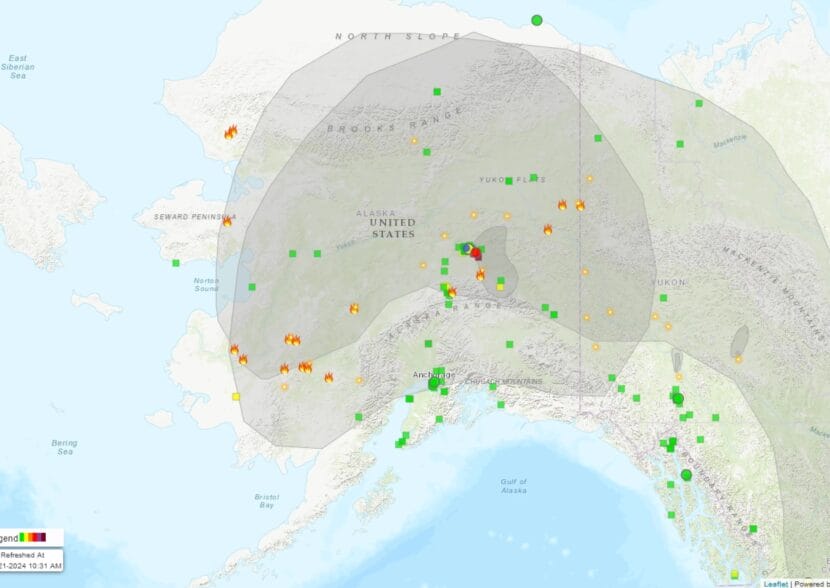
About 140 active wildfires, many in the Eastern Interior, are burning up acreage and sending smoke across the region — with one burning across and closing the Elliott Highway north of Fairbanks.

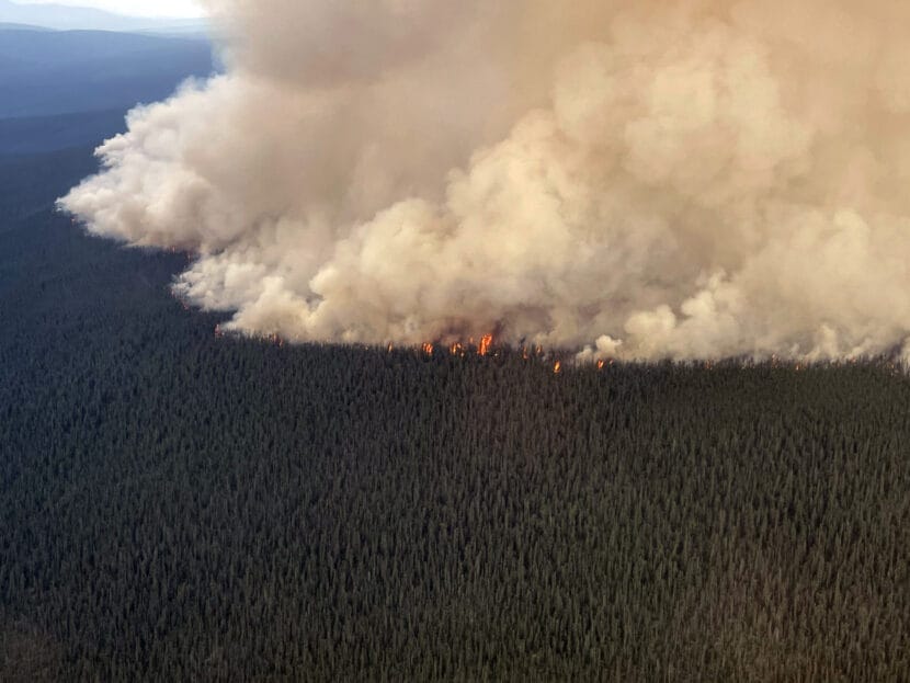
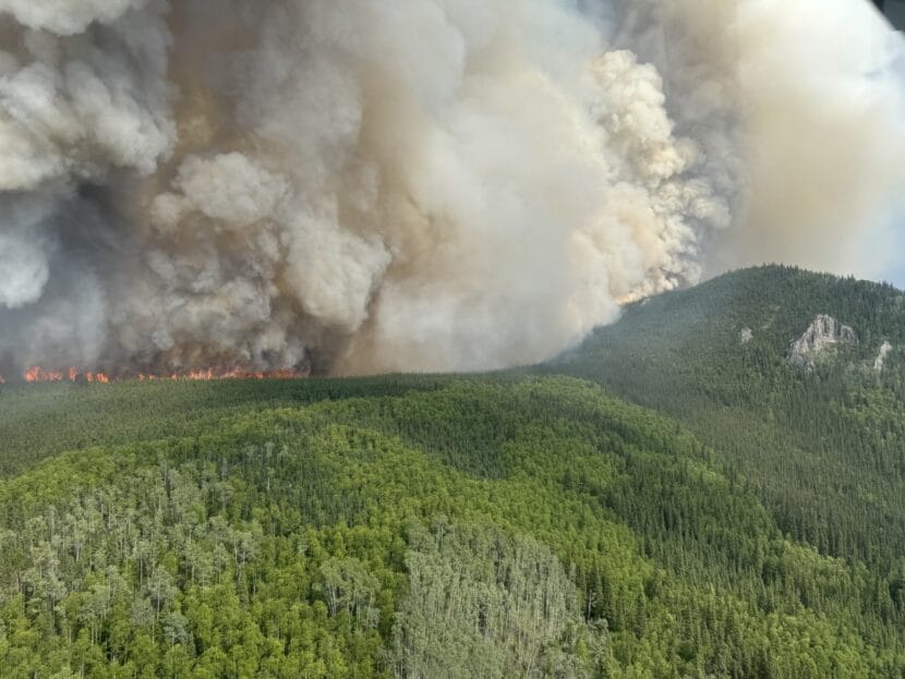
Among about 10 wildfires being fought statewide, the highest priority is the Globe Fire along the highway north of Fairbanks. The fire, which has grown to more than 5,000 acres, prompted an evacuation order between Mileposts 39 to 48, and a highway closure between Mileposts 28 and 48.

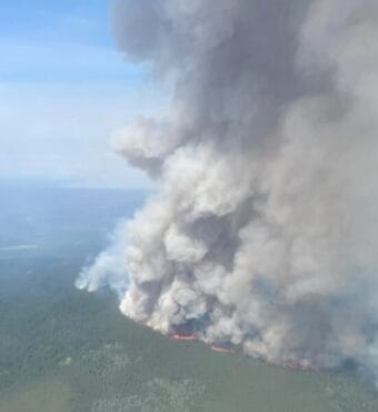
Alaska Fire Service spokesperson Beth Ipsen said the Globe Fire exhibited extreme behavior Thursday. It grew rapidly in erratic winds and hot, dry weather, burning through black spruce.

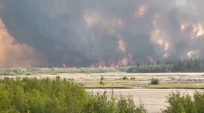
“The fire activity picked up and there was a large column of smoke that collapsed and really impacted the area with hampered visibility, hot air and ash,” Ipsen said.

Ipsen said the fire burned across the Elliott near the Globe Creek Campground. She said the focus is on protecting people and then property.

“There’s cabins, Native allotments, and primary homes in that area,” she said. “I’ve talked to quite a few people that are in Fairbanks, and are really worried about their property, and of course there are some people that decided to stay.”

Ipsen said smokejumpers spent the day checking on residents and structures, clearing surrounding brush and setting up sprinkler systems. Additional firefighters are being mobilized, including two hotshot crews from California that arrived Thursday night.

“And then we are trying to order more crews up there, so it’s going to be increasing, and then also we’re trying to get some heavy equipment,” she said.

Ipsen said the Elliott Highway closure is before the Dalton Highway intersection, so truckers headed to and from the North Slope were among vehicles backed up Thursday. The fire service is coordinating with the state Department of Transportation and Alaska State Troopers on the road closure, which will be lifted when it’s safe.

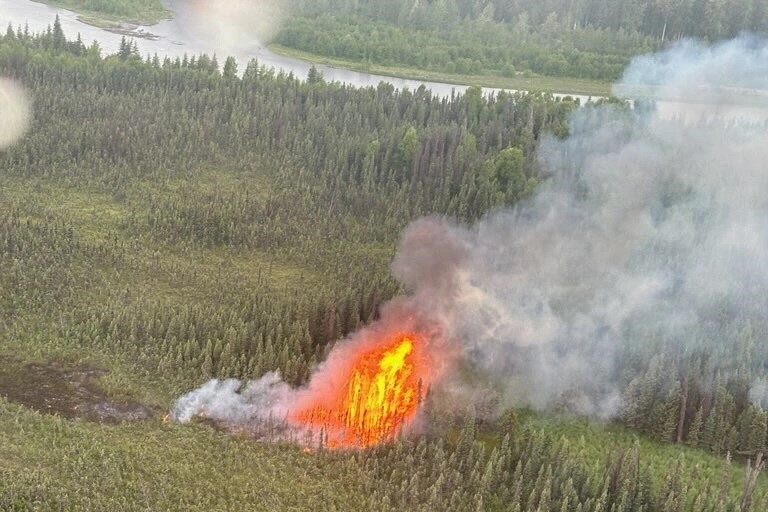
The wildfire situation is intensifying as lightning strikes combined with hot, dry weather continue to create red flag conditions across a wide swath of the state’s mid-section. Alaska Division of Forestry and Fire Protection information officer Sam Harrel said existing fires and new starts have high growth potential.

“Winds like we had on Thursday are just really going to drive them and force them to grow,” Harrel said. “The fuels are very receptive.”

Harrel highlighted a fire that started Thursday night north of Nenana on the Totchaket Slough.

“It has the potential to grow and it’s in a full response area. There’s a lot of cabins and Native allotments along the Tanana River there,” he said.

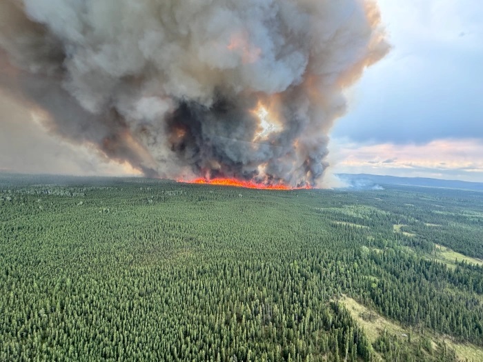
Meanwhile, the hot, dry windy conditions have resulted in significant growth of the state’s two largest wildfires: the McDonald and Clear Fires which have burned together, charring over 100,000 acres on military training lands across the Tanana River from Fairbanks and Richardson Highway communities to the southeast.

Residents along the Elliott Highway are told to evacuate as a fast-moving wildfire grows

An aerial view of the Globe Fire on the night of Wednesday, June 26, 2024. (From Ryan McPherson/BLM AFS)

A fast-moving wildfire near the Elliott Highway prompted officials to ask residents to evacuate Wednesday night between Mile 41 and Mile 43 of the highway.

Alaska Fire Service spokeswoman Beth Ipsen said a state Department of Transportation work camp and a few homes are in the path of the Globe Fire, which was initially reported to be about one acre Tuesday.

“And then on Wednesday afternoon, we got reports that fire activity had significantly picked up and was moving towards the highway,” Ipsen said.

An overflight confirmed the fire’s rapid growth.

“It was estimated at more than a thousand acres and about a mile from the closest structure, and since it’s moving through black spruce, its moving rather quickly,” Ipsen said.

Ipsen said communications are difficult in the area, and Alaska State Troopers are helping.

“(We’re) getting the word out that this fire could impact the road between mile markers 37 and 52, but the residents between miles 41 and 43 are what we’re most concerned about.”

Ipsen said smokejumpers, water and retardant drops have been deployed on the Globe Fire.

Meanwhile, work continues on two other Interior wildfires off the Steese Highway. The Deception Pup Fire near Central and the Flasco Fire near Circle were hit aggressively with water and retardant late Tuesday, and Ipsen said additional resources are being sent in to aid with further suppression.

“More crews, specifically hotshot crews, two hotshot crews out of California that will drive out and help with those fires,” she said. “We’re also getting a Type 3 incident management team from Idaho that’s going to be taking over the effort on a group of fires, including these two fires, in that general vicinity of the Steese Highway.”

Red Flag conditions are forecast for much of the Interior, and wildfire activity has spurred an increase in statewide preparedness to Level 4, just shy of the highest level: 5.

The McDonald Fire burns toward the Tanana River on the night of Monday, June 24, 2024. (From Ethan Paul/BLM AFS)

The state’s two largest wildfires, the lightning-caused McDonald and Clear Fires south of Fairbanks, continue to put up heavy smoke as they burn across military training grounds west of the Tanana River. Fire information officer Terry Solomon said the blazes remain in largely undeveloped areas.

“There’s some different military infrastructure, some survival cabins and things like that,” Solomon said.

A lot of work has gone into protecting private cabins on the southern edge of the McDonald Fire. Solomon said managers are keeping a close eye on the fire’s eastern perimeter along the Tanana River and Richardson Highway.

“We do have engines and some crews that are assigned to monitor the east side of the river, just in case something were to jump the river,” he said.

As of Wednesday, the McDonald Fire was sized at over 62,000 acres, and the Clear Fire was estimated to have burned more than 23,000 acres.

More than 100 wildfires are burning in Alaska, many of them in the Interior

An aerial view of the McDonald Fire burning through black spruce near Salcha on Thursday, June 20, 2024. The fire has since grown to more than 54,000 acres. (From Tasha Shields/BLM AFS)

As Alaska’s wildfire season ramps up, fire officials say the Interior is facing high heat and dry conditions that already have the state requesting Outside crews and aircraft.

Beth Ipsen, a spokeswoman with the federal Bureau of Land Management’s Alaska Fire Service, said Tuesday that about 100 smokejumpers from the Lower 48 are currently in state to fight Alaska wildfires.

“Those are the firefighters, the very experienced firefighters that parachute out of airplanes,” Ipsen said. “They’re (the) ones that we use predominantly for that initial response to fires, especially in remote locations.”

By Tuesday, firefighters were dealing with more than 100 wildfires statewide, many of them in the Interior. The fires are burning about 130,000 acres total, mostly in remote areas. There have been no reports of damage to cabins or other structures, though residents in a couple areas have been told to be ready to evacuate.

Right now, the McDonald Fire is the state’s largest. It had grown to more than 54,000 acres by Tuesday morning and was burning on military land across the Tanana River from Salcha. Officials said the fire is “advancing from treetop to treetop in some areas” through quick-burning black spruce, with 83 firefighters and support personnel working to contain it.

vid_MID_McDonald_119_20240609

“It’s still west of the Tanana River and we’d like to keep it there, because on the other side of the Tanana River are Salcha, Harding Lake and a lot of homes,” Ipsen said.

More than 10,000 lightning strikes were recorded across the state on Sunday and Monday, according to Ipsen, causing a string of fires north of Fairbanks along the Chatanika River. The Fairbanks North Star Borough has issued a Level 2 evacuation-preparedness notice for residents in the area – the second in the “Ready, Set, Go” sequence for approaching wildfires.

The numerous wildfires are affecting Interior driving conditions, with state transportation officials urging motorists in the region to drive with headlights on. Fairbanks public radio station KUAC reported Monday that smoke is also producing air quality advisories in Fairbanks and other parts of the Interior.

In Southcentral Alaska, fire danger has been markedly lower this year, according to Ipsen.

Ipsen said the region has seen traditionally lower temperatures than the Interior, as well as occasional rains. Although more than 1,000 lightning strikes were recorded in the Matanuska-Susitna Borough on Sunday, a small fire near the Willow Airport had burned less than an acre by Monday.

Ipsen said that according to climatologist Rick Thoman, Alaska remains below average so far this year for acreage burned by wildfires. She credited that initial success to quick attacks by fire crews, especially smokejumpers delivered by helicopter in “helitack” flights.

“But we’re getting into the time of the year where with the sustained dry weather, it’s drying the deeper ground layers out, and we’re starting to see some of those fires being a little bit harder to get a handle on,” she said. “And that will continue if we continue to have that hot, dry weather – there’s no big rain forecast in sight.”

The Susitna Fire burns along the Susitna River on Sunday, June 23, 2024 near the Willow Airport. The fire burned less than an acre before it was knocked down by firefighting aircraft. (From Mat-Su Helitack/Alaska Division of Forestry)

Dry conditions in the Lower 48 could also cause the fire crews and support aircraft currently helping Alaska-based firefighters to be called elsewhere, Ipsen said.

Ipsen said Alaska is unique in having a relatively low proportion of wildfires started by people, about 60% versus 80% in the Lower 48. She said Alaskans can assist fire crews by keeping it that way.

“We’re pretty thankful that there hasn’t been a lot of impacts with human-caused fires,” she said. “It’s been mostly lightning-caused fires lately, so we can just have people help us out with that.”

Homeowners can also make homes more resilient to wildfires by cleaning gutters and limbing nearby spruce trees, Ipsen said.

Lightning sparks wildfires across Interior Alaska

A map generated by AirNow.gov shows recent wildfires around the state and the smoke that they generate. (From Airnow.gov)

Wildfire activity ramped over the weekend due to hot, dry conditions and numerous lightning strikes, including over 6,500 Sunday.

“Sunday is definitely our largest amount of lightning for one day this season,” said Sam Harrel, a spokesman for the Alaska Division of Forestry.

Harrel said even prior to Sunday’s lighting, earlier strikes resulted in numerous starts.

“Forty new fires, Friday, Saturday and Sunday,” he said.

Smoke billows up from the 39,700-acre McDonald Fire, burning on military-training land about 30 miles southeast of Fairbanks. (From Alaska Wildland Fire Information)

The new fires were spread across a wide area of the state, from Southwest to the Kenai, Mat-Su and Interior. Among new fires responded to was a 1-acre blaze near the Willow Airport that was hit Sunday night with water and retardant.

“Retardant tanker and air attack responded from Fairbanks, and the tanker was able to make multiple drops with one load of retardant to encircle the fire with retardant, and that allows ground forces to get into place and start to encircle the fire’s edge,” Harrel said.

More forecast hot weather and lightning combined with increasingly dry duff layers has elevated wildfire potential. Harrel said additional firefighters are due from the Lower 48 starting Monday.

“There are three hotshot crews on that flight. On Wednesday, we are expecting another jet load with three hotshot crews on it,” Harrel said.

More firefighting aircraft are also coming from outside, according to Alaska Fire Service information officer Joan Kluwe.

“Water scooping planes and air tankers. There’s also a variety of helicopters,” Kluwe said.

Kluwe said the fire service was working seven fires as of Sunday night, including the McDonald Fire south of Fairbanks where efforts continue to protect cabins on the blaze’s south side.

“They did burnout operations on the west side of those cabins, and then they are also working on creating a contingency line on the east side,” she said.

Meanwhile, Kluwe said a new lightning-caused fire north of the McDonald Fire is also burning on military training grounds. She says the Clear Fire is in an area where there’s unexploded ordnance, which is restricting firefighters to point protection for threatened military assets.

There are over 100 active wildfires burning in the state.

In Juneau, years can pass without a thunderstorm. Why are they so rare?

Juneau lightning
Lightning strikes over Juneau, June 17, 2013. (Photo by Mikko Wilson)

On Tuesday afternoon, Juneau climatologist Rick Fritsch was getting ready for his afternoon shift when the sky darkened suddenly, and the wind picked up. 

“It was rocking the trees, something furious. And my birdhouses were flying, you know, seven ways till Sunday,” Fritsch said. “So I kind of knew that something was up.”

A few minutes later, when he got to the National Weather Service office, a thunderstorm was already in full force. 

“And the office was just buzzing alive with activity,” he said. 

It was an exciting day for Juneau’s meteorologists because thunderstorms rarely happen here. On average, they only happen once about every 2 years. But on Tuesday, all the right ingredients came together. 

Earlier that day, Fritsch’s colleagues had been tracking an unseasonable cold front that was hovering high in the atmosphere just south of Juneau. Meanwhile, on the ground, unsuspecting Juneauites were enjoying a brief moment of sunshine and warmth. 

Now, imagine boiling a pot of water. Cooking up a thunderstorm works much the same way. 

“When it’s a sunny day, and the ground heats up, that’s the element on the stove that’s heating the pot of water from below,” Fritsch said. 

As the water heats up, bubbles of water rise to the top of the pot, while cooler water sinks from the surface. It’s a process called convection. Air does the same thing. 

On warm, sunny days, bubbles of hot air form near the ground and start rising. As they climb higher in the atmosphere, temperatures cool. Especially when there’s a cold front like the one we had on Tuesday.

When the air bubbles cool off, water particles inside them condense and form clouds. This process happens over and over again. Each newly formed cloud pushes the one that came before higher and higher into the atmosphere. 

“And they keep going and going and going,” Fritsch said. “That’s how you build a thunderstorm.”

The clouds stack and combine until, eventually, they form towering, dark gray cumulonimbus clouds. 

These storm clouds are powerful. When they burst, they release a deluge of rain, gusty wind, occasional hail storms — and of course, thunder and lightning.

But the chaos is usually brief. On Tuesday, it lasted just about 30 minutes. That’s because a thunderstorm is its own worst enemy. 

“Basically it kills itself because then it rains out, and it cools the ground underneath it,” Fritsch said. “You take away the heat source. You take away the fuel, if you will, for the thunderstorm.”

And in Juneau, thunderstorms have a couple of other adversaries. 

The first is the ice field. It stands between Juneau and British Columbia to the east, where hot stretches in the summer create massive thunderstorms. Lightning from these storms has sparked some of the Canadian wildfires that have become so prevalent.

But these powerful storms usually can’t make it to Juneau. 

“These thunderstorms grow and grow and grow and they get really exciting. And meteorologists get all tripped out about it, like, ‘Oh, this is really cool,’” Fritsch said. “And then it hits the icefield, you take away the heat, the fuel source, and it just peters out.” 

The storm deflates. 

“All of a sudden it just turns into a rainstorm, a rain shower,” Fritsch said. 

The other adversary, Fritsch said, is Juneau’s northern latitude. 

“We live at 58 north,” he said. “And physically, the atmosphere is thinner the closer you go to the pole.”

At lower latitudes, there is a thicker layer of atmosphere separating the surface of the Earth from space. Which means thunder clouds have plenty of room to grow. Near the equator, they can get up to 50,000 feet, or nearly ten miles, tall. 

In Southeast Alaska, the troposphere — that’s the part of the atmosphere where most weather forms — is only 15,000 to 20,000 feet thick.

“There’s not as much potential or ability for the thunderstorms to really grow to the point where they can manifest, like something in Kansas or Iowa,” Fritsch said. 

So even when thunderstorms do form, they’re typically milder than they might be in the lower 48. In fact, Southeast Alaska has only had one severe thunderstorm warning in Fritsch’s 18 years forecasting here — in Misty Fjords, back in 2019.

“The only time I’ve ever seen it. As a matter of fact, the only time since our weather station has been in existence,” Fritsch. “And that goes back to the 1890s.”

So if you missed Tuesday’s lightshow, you might have to wait a while for the next one.

Widespread high water and flooding continues for lower Kuskokwim communities

Floodwaters rise in Bethel’s Alligator Acres neighborhood on May 9, 2024. (Photo by MaryCait Dolan/KYUK)

Kwethluk remains on flood warning, while Bethel and lower Kuskokwim communities are on flood advisory as the river swells over its banks.

National Weather Service Hydrologist Johnse Ostman said on KYUK morning show Coffee at KYUK on Thursday that high water is widespread throughout the lower Kuskokwim region.

“We’ve seen high water all the way from below lower Kalskag down through Bethel pretty much right to the breakup front, which last night was sitting about two miles downstream of Sunshine Slough between Napaskiak and Napakiak,” Ostman said.

Ostman said the high water isn’t just confined to the Kuskokwim main channel – the tundra is flooding as well. He says he believes that is contributing to the high water throughout the region.

Below is a summary of the flood and ice situations, moving south down the Kuskokwim River: 

Tuluksak and Akiak, which were major points of concern earlier in the week, are still flooding or partly flooding, but Ostman says they’re looking better than they were. Tuluksak continues to have issues with drinking water production after its source pond was inundated in the flooding, while as of Wednesday night (May 8), Akiak’s airport was still surrounded by water.

As of Wednesday evening, Akiachak still had intact ice in front of town, and high water had approached the power plant.

“Even though the water is very high surrounding them, they didn’t have any flood impacts,” Ostman said.

Kwethluk is still experiencing some of the worst flooding in the region. Ostman said that there’s ice running through the area, and that the waterlogged tundra and moving ice may be increasing water levels even more.

“Kwethluk is a real big concern for us today we’re going to be going back up there, taking a look,” Ostman said. “We know that all the whole village has water in it and you know we’re trying to make sure that they know what to do but after speaking with them being on the ground last night with them. They’re pretty prepared and know what their steps are.

Two canoers paddle their way out of the floodwaters in Bethel’s Alligator Acres neighborhood. May 9, 2024. (Photo by MaryCait Dolan/KYUK)

Roads in the neighborhoods around Brown Slough in Bethel are covered with water, and Bethel schools announced early Thursday morning that flooding disrupted bus routes for students.

According to the Kuskokwim River gauge at Bethel, the river level rose around two feet between 8 p.m. Wednesday and 8 a.m. Thursday. The 8 a.m. river level of 10.85 feet puts Bethel well into the minor flooding stage, according to the National Weather Service’s metrics.

Roughly 6 miles downriver of Bethel in Napaskiak, the situation was developing rapidly Thursday morning. Napaskiak resident and Bethel Search and Rescue member Earl Samuelson said as of Thursday morning, ice was jammed in front of town.

“Just looking at the water levels here, we are extremely high right now,” Samuelson said. “All of the low-lying areas are now full of water. Water’s come over multiple places on the bank in front of town, and the north bank and is still gushing in.”

Samuelson continued: “I did an aerial survey with the drone just about 30 minutes ago, it showed that ice jam, the back end of it was right out here by the airport all the way to Oscarville.”

Flooding in Napaskiak on May 9, 2024. (Photo by Kristen Maxie)

As of Thursday morning, water had covered the boardwalk serving as the main access point to the school evacuation point, but Samuleson confirmed the village had a backup plan in place to utilize another boardwalk.

Ostman said Oscarville looks similar to Napaskiak.

“Oscarville has water over their boardwalk this morning. A resident there’s reported that it’s about as high as it was during Typhoon Merbok during that storm they were still able to access their evacuation point which is at the school.”

Ostman said as of Wednesday evening, the breakup front sat between Napaskiak and Napakiak, but that may have moved during the night.

“We had a report last night that they could hear the ice grinding at the breakup front so it it quite possibly as moved down a little bit further.”

Ostman said the National Weather Service plans to fly morning and evening RiverWatch flights where possible.

A man wades down a flooded Sixth Avenue in Bethel on May 9, 2024. (Photo by MaryCait Dolan/KYUK)

“Our plans are just to continue to monitor this until flood threats and flooding has ceased for all villages upstream of the Johnson River.”

But, he said, he doesn’t expect additional slugs of ice from far upriver that could compound the lower river jams.

“As far as we know, there should be no more significant runs of ice coming from the upper Kuskokwim,” Ostman said.

He added that warmer temperatures in the coming days should degrade ice at the breakup front, and also increase snowmelt runoff from the upper river. What impact that could have on lower Kuskokwim communities remains unclear.

Breakup and flood-related information can change quickly, and this article may be updated to reflect more current information.

Share photos or observations with KYUK at 907-543-0223 or by emailing news@kyuk.org.

Site notifications
Update notification options
Subscribe to notifications