Weather

Technology that detects volcanoes and nuclear explosions will listen for avalanches in Juneau

Pat Dryer (left) and Scott Havens (right) install the finishing touches to bring an infrasound avalanche detection system online (Photo by Anna Canny/KTOO)

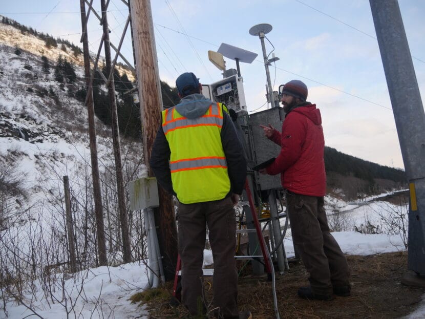
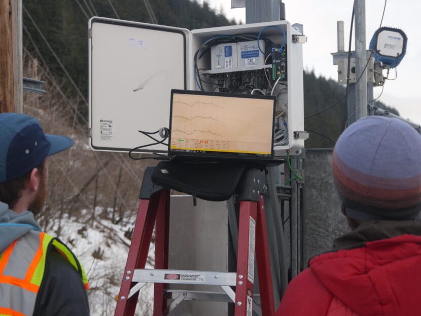
On a sunny February afternoon by the roadside of Thane Road, Scott Havens opened the door of a nondescript, white metal box to reveal a jumble of sensors and computer cables. Then he pointed to the steep slope of Mt. Roberts across the road.

“As the avalanche is coming down, it’s going to create that rumble that we’re picking up,” Havens said.

Humans can’t hear most of the rumbling generated by snow coming down the mountain because it’s infrasound — a kind of sound that’s too low-frequency for our ears to pick up.

Picking up infrasound could help Alaska Department of Transportation track high mountain avalanches that often go undetected. That in turn could improve their avalanche mitigation strategies and shorten the closures along Thane Road every winter.

All kinds of things generate infrasound. Similar detection systems have been used to keep track of volcanic eruptions and illegal nuclear weapons tests across the world. Havens’ company, Snowbound Solutions, is pioneering infrasound for avalanche monitoring using sensors developed with researchers at Boise State University.

The sensors measure the subtle changes in atmospheric pressure that are generated by every sound. On Thane Road, the challenge is distinguishing between noises like helicopters, cruise ships or the humming of the power lines.

“Like, we’re picking up this car that’s coming by us,” Havens said. “As it’s moving through the atmosphere, it’s emitting infrasound. And so with the array, we can basically track where that’s coming from.”

This white metal box houses sensors and communication equipment that will alert Alaska Department of Transportation when an avalanche occurs on the slopes above Thane Rd. (Photo by Anna Canny/KTOO)

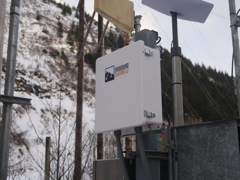
The infrasound detection boxes are arranged in triangles at the bases of different avalanche paths along Thane Road. Each triangle is called an array.

“The array works a lot like your ears. As the sound moves across the array, you can differentiate where the sound is coming from because it’ll arrive at each of those sensors at a different time,” Havens said.

And when the sound can be traced to somewhere up the slope, in an avalanche start zone, they’ll know it was an avalanche.

Snowbound Solutions has already deployed similar systems in Utah, California, Colorado and New Zealand. The system in Juneau, funded by a grant from the Alaska Department of Transportation, will be the first in Alaska.

Pat Dryer is the avalanche program specialist for the Alaska Department of Transportation on Thane Road. He says infrasound is part of the department’s larger effort to develop an avalanche monitoring and warning system on Thane road.

According to Dryer, “hearing” avalanches with infrasound is crucial because it’s often impossible to see them. Most don’t make it all the way down to the road. They happen high up the mountain, where storms can cloud visibility, or they happen at night.

“We’re assuming that avalanches are occurring, or we’re predicting that they are occurring, but not having that positive feedback loop that something is happening,” Dryer said.

Dryer said that over time, the record they’ll build of when avalanches happen and in what weather conditions will help improve their avalanche forecasting.

“We can start to make some assumptions or even predictions of when they’ll occur in the future,” he said. “So that we can better refine our methods of managing that hazard or closing the roadway.”

Dryer and Havens read infrasound signals (Photo by Anna Canny/KTOO)

More data will also help Havens refine the technology so it may be possible to identify avalanches not just by their location, but by their distinct soundwaves. Avalanche infrasound does have a kind of recognizable rumble, but the signal still varies a lot based on the type of avalanche and its size.

“So yeah, we’re hoping to figure out what an avalanche sounds like? Like, what is the kind of characteristic signal,” Havens said. “If we can apply some fancy machine learning or AI algorithms, can we start picking out and classifying these better?”

And in the future, Havens said, infrasound detection could be used to monitor hazards like rockfalls and landslides too.

Trees are expanding north in Alaska’s Arctic as a result of sea ice loss

White spruce trees dot the tundra in the Brooks Range. These trees are better able to survive harsh conditions due to heavy winter snowfall, a result of Arctic sea ice loss. (Photo courtesy Colin Maher)

Trees are gaining ground in the Arctic as a result of climate change. A group of scientists studying tree cover in Alaska’s Brooks Range found that trees are expanding north and at higher elevations, in part due to the loss of Arctic sea ice, which is disappearing because of human-caused global warming.

When sea ice retreats, large areas of open water are left in its place. Warm conditions speed up evaporation, leading to heavier snowfall on nearby land, said Patrick Sullivan, director of the Environment and Natural Resources Institute at the University of Alaska Anchorage.

“You basically have this blanket of snow that covers up small seedlings and saplings, and protects them,” he said.

That thicker snow layer is making it easier for trees to survive in harsh Arctic conditions.

“In the winter in the Arctic, the wind picks up all of these spiky snow crystals, and basically batters trees and other vegetation that stick up above the snow,” Sullivan said. “And so the deeper the snow, more of the population gets protected.”

Sullivan said snow also serves as an insulator, keeping the ground warm enough that soil microbes can continue to churn out nutrients for growing trees.

Permafrost thaw, another effect of climate change, is also at play, said Sullivan. The thick, insulating layers of snow are speeding up the thaw, making it easier for trees to take hold in the soil and grow.

A cross section of a tree with increasingly wider rings.
A white spruce tree core from the Brooks Range shows increasingly wider rings, indicating accelerated growth. Scientists correlated the rings with growing areas of open water due to sea ice loss. (Photo courtesy Colin Maher)

Rapid growth in white spruce trees can actually be linked to periods of open water at sea, said Colin Maher, a postdoctoral fellow at UAA who studies tree rings.

“If you look at the tree ring measurements, you would see an increasing trend in ring widths. They start kind of small, and then they get bigger and bigger. And that’s what the open water looks like as well,” Maher said. “It’s increasing rapidly.”

Roman Dial, a math and biology professor at Alaska Pacific University who co-authored a paper in Science with Sullivan and Maher, studied satellite imagery from around the circumpolar north and found that the tree line is advancing in many parts of the Arctic.

Dial said this shift in the Arctic ecosystem isn’t limited just to trees – animals like moose, beavers, black bears, and even salmon are moving north too. The availability of the subsistence animals that many communities rely on is also changing.

“What does that mean for people who live there? It’s hard to say,” Dial said. “It’s a change. You can talk to people in Kotzebue, and they’re excited about the huge chum salmon runs that they’re getting, but they’re kind of bummed out that the caribou populations are crashing.”

Dial said it also remains to be seen how increased tree cover will affect the climate. Trees serve an important role as a “carbon sink,” storing carbon dioxide, which is a major driver of global warming. But at the same time, dark trees like spruce soak up sunlight instead of reflecting it back the way bare, snowy tundra does. Dial said trees trapping heat like that could speed up Arctic warming.

Scientists explore whether to add a ‘Category 6’ designation for hurricanes

Residents of Tacloban in the central Philippines in 2013, after Typhoon Haiyan devastated the area. Scientists are renewing calls for a new Category 6 designation for the the most powerful hurricanes and typhoons, such as Haiyan. (Aaron Favila/AP)

Hurricanes are rated on a scale from one to five, depending on their wind speeds. The higher the speed, the higher the category. But as climate change makes powerful storms more common, it may be necessary to add a sixth category, according to a new paper published by leading hurricane researchers.

The current five point scale, called the Saffir-Simpson scale, was introduced in the 1970s and is used by forecasters around the world including at the National Hurricane Center in Florida. Under the scale, storms with maximum wind speeds of 157 miles per hour or higher are designated as Category 5 hurricanes.

Category 5 storms used to be relatively rare. But climate change is making them more common, research shows. And some recent Category 5 storms have had such high wind speeds that it would make more sense to assign them to a Category 6, if such a category existed, the authors argue.

The authors of the new paper, James Kossin of the First Street Foundation and Michael Wehner of the Lawrence Berkeley National Laboratory, have been studying the effects of climate change on hurricanes for decades. They propose that Category 5 should include hurricanes with maximum sustained winds of 157 to 192 miles per hour, and that a new Category 6 should include any storm with wind speeds above 192 miles per hour.

Under the new scale, Category 6 hurricanes would be exceedingly rare right now. For example, it might apply to 2013’s Typhoon Haiyan devastated the Philippines with wind speeds around 195 miles per hour. In fact, scientists in Taiwan argued at the time that Haiyan necessitated a new category designation.

Four other storms since 2013 would qualify for Category 6 status, including 2015’s Hurricane Patricia, which hit Mexico, and three typhoons that formed near the Philippines in 2016, 2020 and 2021.

But other powerful storms wouldn’t make the cut. For example, Hurricane Irma had sustained winds around 185 miles per hour when it hit the U.S. Virgin Islands in 2018 as a Category 5 storm. The wind damage from Irma led some residents to suggest that the storm should have been given a Category 6 designation by forecasters, because they felt that they hadn’t been adequately warned about the extraordinarily dangerous wind. But under the new proposed scale Irma would remain a Category 5 storm.

Similarly, Hurricane Dorian had wind speeds of about 185 miles per hour when it made landfall in the Bahamas in 2019. It was, and would remain, a Category 5 storm.

And the new scale would do little to convey the particular danger from storms such as Hurricane Harvey, Hurricane Florence or Hurricane Ida, which fit cleanly into the current wind speed scale, but caused deadly flooding from extreme rain. Climate change is to blame – studies have found that hurricanes and other storms are dropping more rain because a warmer atmosphere can hold more water.

The National Hurricane Center, which handles official category designations for hurricanes that threaten the United States and its territories, has not weighed in on the question of adding a Category 6. The center has done other things to update hurricane forecasts in response to climate change, however, including new storm surge forecasting tools, and upgrades that allow forecasters to predict the intensity and location of storms earlier, so people have more time to prepare and evacuate.

Copyright 2024 NPR. To see more, visit https://www.npr.org.

Alaska’s recent cold snap tested critical infrastructure, including in Mertarvik

The addition of six new homes in Mertarvik means an added draw on power, and a recent state-wide cold snap was too much for the new community’s generators. A three-day power outage has resulted in frozen and broken pipes at the local water plant. (Emily Schwing/KYUK)

A recent cold snap in rural Alaska tested the limits of power plants from Anchorage to the Yukon-Kuskokwim Delta. In Mertarvik, a loss of power meant that other critical infrastructure also saw catastrophic damage.

Multiple social media posts last week called for donations of both bottled water and firewood after the community of roughly 230 people lost power for three days.

“Everything is powered by a generator, but we don’t have a backup generator,” said Calvin Tom, Mertarvik’s tribal administrator.

Tom said that the main generator draws power from batteries that weren’t able to keep up with temperatures that fell to nearly 17 below zero Fahrenheit. That meant that the entire community was without electricity for more than three days.

“For some reason our batteries just drained, so on [Jan. 28] we didn’t have any power all day until the evening. It was all good the following night, and next morning I woke up to no power. So we came to a determination that the batteries were being drained,” Tom explained.

Tom said that they tried a few different methods: insulating the batteries from underneath, lifting them off a cold floor, charging them up and using a space heater to keep them warm, but they simply wouldn’t stay charged and couldn’t keep up with demand.

“The two smaller generators that we are using currently can’t take the load,” Tom said.

In the last year, the population in Mertarvik has increased from just over 180 people to nearly 230. That’s because at least half a dozen new homes were built there last year to house families relocating from Newtok, where permafrost is melting and the land is waterlogged and sinking.

With help from at least one federal agency and the Alaska Division of Homeland Security and Emergency Management, new batteries arrived from Bethel on Jan. 31 and the lights are now on in Mertarvik. But without electricity for a few days, the water plant froze. Now Tom said that Mertarvik is waiting for repair parts to fix broken pipes.

“There’s a little creek, it’s like a fresh spring water. It’s about a quarter mile outside the village and people get their water over there; you just need a four-wheeler or snowmachine to go to it,” Tom said.

According to the Alaska Division of Homeland Security and Emergency Management, both the United States Bureau of Indian Affairs (BIA) and the Yukon-Kuskokwim Health Corporation have shipped pallets of bottled water to Mertarvik. The BIA has also provided a shipment of firewood.

During cold snaps, a spokesperson said that the division often sees problems with critical infrastructure due to spikes in energy usage, just like the one that settled in over most of the state over the last two weeks.

How are atmospheric rivers affected by climate change?

Residents stand along a flooded street in Santa Barbara, California, as a powerful atmospheric river pummels the region. The storm has caused landslides, power outages, and road and airport closures across Southern California. (Mario Tama/Getty Images)

The second atmospheric river to hit the West Coast in as many weeks has stalled over Southern California, dumping more than 9 inches of rain over 24 hours in some areas near Los Angeles. Streets are flooded in Santa Barbara and Los Angeles; creeks are raging like rivers; and rainfall records in Los Angeles County are nearing all-time records.

At least three people were reported to have died due to storm-related injuries, including two people killed by fallen trees. As of Tuesday morning, the severe weather had knocked out power for more than 150,000 Californians.

The National Weather Service said Los Angeles received nearly half of its average seasonal rainfall in just two days, but the storm isn’t over yet.

Areas east and south of Los Angeles could see several more inches of rainfall through Wednesday. That includes San Diego, which was inundated a few weeks ago by a different storm.

Atmospheric rivers are well-known weather phenomena along the West Coast. Several make landfall each winter, routinely delivering a hefty chunk of the area’s annual precipitation. But the intensity of recent atmospheric rivers is almost certainly affected by human-caused climate change, says Daniel Swain, a climate scientist at the University of California, Los Angeles.

Climate change has made the ocean’s surface warmer, and during an El Niño year like this one, sea water is even hotter. The extra heat helps water evaporate into the air, where winds concentrate it into long, narrow bands flowing from west to east across the Pacific, like a river in the sky, Swain says. An atmospheric river can hold as much as 15 times as much water as the Mississippi River.

Human-driven climate change has primed the atmosphere to hold more of that water. Atmospheric temperatures have risen about 2 degrees Fahrenheit (just over 1 degree Celsius) since the late 1800s, when people started burning massive volumes of fossil fuels. The atmosphere can hold about 4% more water for every degree Fahrenheit warmer it gets. When that moist air hits mountains on the California coast and gets pushed upwards, the air cools and its water gets squeezed out, like from a sponge.

Swain estimates those sky-rivers can carry and deliver about 5 to 15% more precipitation now than they would have in a world untouched by climate change.

That might not sound like a lot, but it can—and does—increase the chances of triggering catastrophic flooding, Swain says.

In 2017, a series of atmospheric rivers slammed into Northern California, dropping nearly 20 inches of rain across the upstream watershed in less than a week. The rainfall fell in two pulses, one after another, filling a reservoir and overtopping the Oroville dam, causing catastrophic flooding to communities downstream.

The back-to-back atmospheric rivers that drove the Oroville floods highlighted a growing risk, says Allison Michaelis, an atmospheric river expert at Northern Illinois University and the lead of a study on the Oroville event. “With these atmospheric rivers occurring in succession, it doesn’t leave a lot of recovery time in between these precipitation events. So it can turn what would have been a beneficial storm into a more hazardous situation,” she says.

It’s not yet clear if or how climate change is affecting those groups of storms—”families,” as one study calls them.

It’s also too early to say exactly how much more likely or intense climate change made the current storms on the West Coast. But “in general, we can expect them to all be intensified to some degree” by human-driven climate change, Michaelis says.

Scientists also don’t yet know if climate change is affecting how often atmospheric rivers form, or where they go. And climate change doesn’t mean that “every single atmospheric river storm that we are going to experience in the next couple of years will be bigger than every other storm” in history, says Samantha Stevenson, an atmospheric and climate scientist at the University of California, Santa Barbara.

But West Coast communities do need to “be prepared in general for dealing with these extremes now,” says Stevenson. “Because we know that they’re a feature of the climate and their impacts are only going to get worse.”

Copyright 2024 NPR. To see more, visit https://www.npr.org.

Juneau breaks record for snowiest January ever with more than 76 inches

Jerry Eldemar makes heart-shaped snow sculptures in downtown Juneau on Tuesday, Jan. 16, 2024. (Clarise Larson/KTOO)

Last month was officially Juneau’s snowiest January on record, with 76.8 inches of snow recorded at Juneau International Airport. That breaks the previous record of 75.2 inches set in 2009. 

“It’s been quite a month,” said National Weather Service meteorologist Edward Liske. “And that snow total for this January was also the second highest snowfall for any month on record. The only one that’s higher is February 1965, which was 86.3 inches.”

Juneau’s accomplishment was unique compared to the rest of Southeast Alaska. Snow totals in the capital dwarfed accumulations in nearby communities like Haines, Skagway and Gustavus.

Liske said a cold snap in early January set the stage. During the rest of the month, moist storm fronts from the south converged with the lingering cold air over Juneau, generating two consecutive winter storms.

“Both those storms had this scenario stick around for a good three days,” Liske said. “That was near probably 90% of the snow that we got for the month.”

The first storm dropped 33.1 inches at the National Weather Service Office in the Mendenhall Valley. The second, which happened just a week later, dropped 31.2 inches. 

More than 30 inches of snowfall over the holiday weekend buried the Behrends neighborhood and pushed the urban avalanche advisory to “high.” (Clarise Larson/KTOO)

The snow disrupted travel all month long. It triggered a series of avalanches across town. At least one roof collapsed. And numerous boats sank under its weight. 

The snowfall may seem unusual given that 2024 is an El Niño year. The natural climate phenomenon is usually characterized by wet, warmer weather, leading to more winter rain. 

“But it’s not a hard and fast rule,” Liske said. “If we get the right combination of cold air snaps and these warm wet systems coming up, we can get buried with snow. So we’ve had other El Niño winters where we’ve just been buried.”

Since it stayed cold in Juneau this January, most of that extra precipitation came down as snow.

A brief bout of warmer temperatures and rain last week melted most of Juneau’s snow cover — but only for a brief moment. This week, another shorter storm blanketed the city in more than 13 inches of snow that fell in less than 24 hours.

And more is on the way. The National Weather Service has issued a winter weather advisory effective from 6 a.m. to 6 p.m. Saturday, with the potential for another 4 inches of fresh powder.

Site notifications
Update notification options
Subscribe to notifications