Science & Tech

Yakutat to celebrate return of the terns


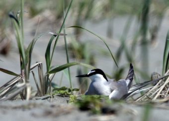
An Aleutian tern nests near a Yakutat beach. The rare seabirds will be celebrated at this year’s Yakutat Tern festival. Image from www.yakutatternfestival.org.

Yakutat is gearing up for an influx of birders.

They’re coming to the northern Southeast Alaska community to celebrate the return of the Aleutian tern, a somewhat rare seabird.

There’s a lot yet to learn about its migration patterns. But what Yakutat residents do know is that the seabirds return every spring.

“We have one of the southernmost known and one of the largest known breeding colonies of Aleutian tern,” says Susan Oehlers, a Forest Service biologist and one of the Yakutat Tern Festival’s organizers.

“So we decided we wanted to have a birding festival highlighting the Aleutian terns as well as the other natural and cultural resources here in Yakutat,” she says.

The tern festival began in 2011. This year’s event runs May 30th to June 2nd.

It attracts bird-watchers from around the state and the Lower 48.

But Oehlers says it’s not all about birds.

“It’s a very family-friendly festival. It’s for birders and non birders. So we have field trips looking at birds, but also all the great scenery we have here like the Hubbard Glacier and Russell Fjord and getting out into the bay,” she says.

Bird-banding and calling sessions are among events planned for kids.

The festival has a focus on Alaska Native culture and will include performances by Yakutat’s Mount Saint Elias Dancers.

Tlingit carver Doug Chilton is the festival’s featured artist. Authors and language experts Richard and Nora Marks Dauenhauer are the keynote speakers.

Festival field trips will take birders to the Aleutian tern’s breeding grounds. But they won’t get too close.

“They are sensitive to disturbance. So we keep a distance from where they’re nesting. But you can still get a pretty close-up view of them and possibly even see one on a nest,” she says.

The Aleutian tern lives in Alaska and eastern Siberia. Researchers are studying Yakutat’s colony to learn more population trends, nesting and migration patterns.

Geologist discovers underwater volcano in southeast Alaska

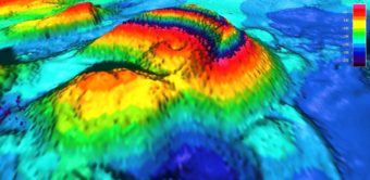
This graphic image provided by Forest Service Geologist Jim Baichtal shows the newly discovered volcano in Behm Canal near Misty Fiords National Monument.

About 10,000 years ago, give or take a couple thousand years, a volcano blew its top in the middle of Behm Canal. The crater is still there, covered by 150 feet or so of ocean. But when the volcano exploded many thousands of years ago, it was not underwater. That’s what makes it so interesting.

Well, that and the fact that nobody currently living knew it was even there until just a few weeks ago.

U.S. Forest Service Geologist Jim Baichtal, who is based on Prince of Wales Island, and Anchorage geologist Sue Karl were looking at some hydrographic surveys, something geologists tend to do.

“When we were done, I noticed the area from Thorne Arm to Rudyerd had been surveyed,” Baichtal said. “I zoomed in and there was this large… some kind of volcano, and two other dome-like structures.”

Karl added that, “This new NOAA survey allowed us to see things that people had never seen before.”

Baichtal and Karl were in Ketchikan recently. They came by KRBD, along with UAS Juneau geology professor Cathy Connor, to talk about the underwater volcano.

Baichtal said that after spotting the cone-shaped mass, he used a special computer program to look more closely at the surveys, and they could see the vent still was intact. They also could tell that it erupted in the air, even though it’s now under quite a bit of water. But, how could they tell that, just by looking at it?

“Because of the shape of the feature itself, it talks about cinders, or some kind of ash that’s airfall,” he said. “It’s an airfall deposit that forms this … cone.”

Karl said a modern example of a similar eruption is Surtsey, a volcanic island in Iceland, which erupted from the sea floor in the 1960s, building itself up and eventually breaching the surface to form the island.

Karl points out that when the newly discovered volcano erupted, sea levels also were lower than they are now, but even with that, “We still have too much depth. We have to call on glacial loading and rebound.”

Okay. What does that mean?

Sprinkles of snow dot precipitous cliffs. Rudyerd Bay area, Southeast Alaska.
Sprinkles of snow dot precipitous cliffs. Rudyerd Bay area, Southeast Alaska, September 2010. (Photo by LCDR Mark Wetzler, NOAA Corps.)

“When you get a thousand feet of ice sitting on the ground, it is very heavy,” she explains. “It actually depresses the earth’s crust. After the glacier melts back, the earth will rebound.”

Like a trampoline, or waterbed, but at a much slower pace.

“So at one time, in Misty Fiords, there was close to 4,000 foot of ice on that site, so the weight of that ice at least pushed down (created) as high as 400 feet of displacement,” Baichtal added.

So, in summary, the volcano erupted within the last 13,000 years, after the ice retreated, as the land was slowly bouncing back, and when sea levels were lower. They figured out most of this stuff just from examining the surveys.

But Baichtal wanted to see it in person, or as close to in person as possible. Luckily, he knows some people who can make that happen: Gary Freitag, with the University of Alaska Fairbanks Marine Advisory Program, and Barbara Morgan with Oceans Alaska. They have an ROV, or remote operated vehicle. It’s a small device that can dive to the bottom of the ocean, get clear video or photographs, and collect samples.

On an unseasonably snowy May morning, they went out with Baichtal on an Allen Marine boat to look for what he calls the “wee beastie on the bottom of the sea.” Using location data from the survey charts, the skipper was able to “park” the catamaran right on top of the crater, and they quickly sent the ROV into the water.

“From that, we could see the angle of the slopes,” he said. “We did one deep dive, about 340 feet down. You could kind of tell the way the thing was put together. The lower material was … lava that was quenched in the marine environment, and the upper stuff was the airfall.”

They also grabbed two rock samples, which will be chemically analyzed to determine a more exact age for the eruption.

Baichtal notes that southern Southeast Alaska isn’t well known for its volcanoes, but there are quite a few in this region.

“We know that we have a lot of volcanoes out in the Aleutians, but if you talk about volcanoes in Southeast, everybody imagines Edgecumbe … when in fact, south of Craig and south of Ketchikan here, we actually have a much larger number of vents and a bigger volcanic complex. It’s just less known,” he said.

New Eddystone Rock with shoals exposed
New Eddystone Rock with shoals exposed August 2010. (Photo by Alan Wu/Wikimedia Commons)

That’s because some are underwater, and those that aren’t are covered by trees. Karl said as people explore more of the area’s wilderness, they’re discovering more vents.

Volcanoes show up along faults in the earth’s crust, so when the fault moves enough to expose magma, that can lead to a volcanic eruption. Since faults don’t go away, volcanic eruptions in Southeast Alaska are possible in the future.

“With the evidence that we have and the geologic age of the things that are there, there is no reason why it couldn’t,” he said. “I wouldn’t be surprised if it did.”

But, Karl said people shouldn’t get anxious about it.

“We have much better technology for detecting the initiation of one of these sorts of things now,” she said. “I don’t think people need to get too worried.”

The newly discovered volcano is very close to New Eddystone Rock, which is what’s left over from another volcano, which may have erupted around the same time frame. They are both near the entrance to Misty Fiords National Monument.

Scientists spot lava flows at Cleveland and Pavlof

Fresh lava flow on the north side of Mount Pavlof
Fresh lava flow on the north side of Mount Pavlof. (Photo by Brandon Wilson)

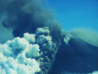
Scientists at the Alaska Volcano Observatory were able to get clear views of two restless volcanoes yesterday. The images show that both Cleveland Volcano in the Aleutian Islands and Pavlof Volcano on the Alaska Peninsula are oozing lava.
Cleveland started erupting earlier this month, with six separate explosions sending up multiple ash clouds. The volcano has been quiet since early last week, but the new satellite imagery shows a lava flow coming out of the southeastern side of the crater. The flow is about 100 yards wide, and a mile long.

Scientists at the Observatory first detected activity at Mount Pavlof Monday morning, but weren’t able to visually confirm an eruption. Monday night, a passing PenAir pilot took a photo that shows a fresh, quarter-mile-long lava flow on the volcano’s northern flank, and steam emanating from the summit.

While the aviation alert level for both volcanoes remains at orange, neither has interfered with air traffic. Only Pavlof has a real-time monitoring network, while Cleveland is monitored remotely, using infrasound sensors and satellites.

Astronauts Go On Spacewalk To Fix Ammonia Leak

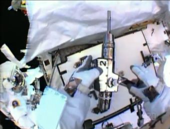
In this image made from video provided by NASA, astronaut Christopher Cassidy, foreground, holds a power wrench as he stows away a coolant pump on the International Space Station on Saturday. Thomas Marshburn is at left. AP

Two astronauts went on a last-minute spacewalk Saturday to replace a pump suspected of being the source of a serious ammonia leak.

It was unclear what caused the ammonia leak, NASA spokesman Rob Navias said, “but the installation of this spare pump package — at least at the moment — seems to have done the trick.”

NASA officials called the spacewalk a success, but said it would take time to see if the leak was indeed stopped. Engineers will review photos the astronauts took at the site.

According to Spaceflight Now, the leak was in the system used to cool “one of eight electrical channels powered by the space station’s main solar panels.”

NASA said the leak never jeopardized the crew at the International Space Station, AP reports, but the agency wanted to fix the problem while it was fresh.

Our Original Post Continues:

As two astronauts make what The Associated Press writes is “a hastily planned spacewalk Saturday to try to fix an ammonia leak in the power system of the International Space Station,” NASA is webcasting.

It’s estimated they’ll be working on the problem for about six hours. The leak is not presenting a danger, NASA says, and the space station still has plenty of power.

Update at 3:08. ET. : New Pump Installed

NASA says astronauts Chris Cassidy and Tom Marshburn replaced a pump controller box suspected of being the source of the ammonia leak. The Associated Press reports they uncovered “no smoking guns” responsible for the problem.

Copyright 2013 NPR. To see more, visit http://www.npr.org/.
Read original article

Astronauts Go On Spacewalk To Fix Ammonia Leak

White House Releases Arctic Strategy

The Coast Guard Cutter Sycamore sits off the coast of Barrow, Alaska, Aug. 12, 2012. The crew of the Sycamore, a 225-foot sea-going buoy tender, travelled to the Arctic Ocean from Cordova in support of Arctic Shield 2012. U.S. Coast Guard photo by Petty Officer 3rd Class Grant DeVuyst.

The eleven page document frequently mentions the Arctic as a region free of conflict and the country’s desire to keep it that way.

The plan lays out three arcing “lines of interest” – to advance U.S. security, pursue responsible Arctic stewardship and to strengthen international cooperation.

Luke Coffey, a fellow at the D.C. based Heritage Foundation, called the strategy welcome news, albeit a bit late.

He cautioned the strategy is very forward looking; it lays out guidelines for future oil and gas exploration and shipping lines.

He said only46 vessels traversed the Northern Sea Route last year.

“Compare that to the 20,000 ships that traveled through the Gulf of Aden off the Horn of Africa,” he said Friday afternoon. “So we are still a long before we start seeing the maritime volume that we’re seeing in some of the warmer climates around the world.”

The strategy says the United States needs to accede to the United Nations Law of the Sea Treaty; something Coffey disputes. He said the country can operate in the Arctic, alongside other sovereign Arctic nations, without signing on to the international agreement.

The U.S. is the only Arctic nation that has not agreed to the treaty.

While the strategy explicitly says security is the number one priority, much of the text focuses on future energy exploration.

Michael LeVine, a lawyer with Oceana in Juneau,said both this administration and the previous one led by President George W. Bush have prioritized oil exploration over the environment.

And while he welcomed commitments to combat climate change, LeVine said it’s tough to balance those promises with promises to continue oil drilling.

“We hope, that moving forward, this administration will stick to its commitment of getting good science and to be prepared before industrial activities are allowed,” he said.

That’s a dig at Shell, which was allowed to proceed with some of its drilling plans despite not having working spill prevention measures.

The strategy says the federal government will cooperate with the state and consult with tribes – which is already policy.

“If they don’t I’m going to be raising a little bit of noise here,” said former North Slope Borough Mayor Edward Itta.

Itta, now a member of U.S. Arctic Research Commission, said the new guidelines are a good first start, but it’s just that. There still needs to be concrete plans developed.

“I’m still somewhat skeptical – until the funding is going to accompany whatever priorities or programs are identified,” he said.

Government officials will travel to Alaska this summer to hold listening sessions and to ask for input on the new policies.

One policy may get lots of attention in the state: Without listing any country in particular, the strategy says the United States should work with other non-Arctic countries that show an interest in the region.

No doubt those countries will have an interest in the vast resource supply.

Arctic scientists take on ‘emerging research questions’

Webcam from the Sea Ice Group at the UAF Geophysical Institute.

Environmental changes from climate warming are hitting the Arctic harder and faster than anyone predicted.  This week, top Arctic scientists have been meeting in Anchorage looking for better ways to investigate and even track the changes and what they could mean.

They are called “emerging research questions,” and the Polar Research Board of the National Academy of Sciences has put together a committee to identify them and recommend how to tackle them.

The committee called on all kinds of other scientists for help – hydrologists, mappers, oceanographers, biologists, weather analysts, sociologists, anthropologists, geologists and more.

Committee co-chair, Alaska anthropologist Henry Huntington, says the emerging issues are ones that scientists did not anticipate.

“Many of the important questions are things we’ve been asking for quite some time and are continuing to answer and refining our answers for,” Huntington said. “The emerging questions are what are the things that are new that we have not really been thinking about or anticipating.”

A really big one is weather, and if a connection can be drawn between changing conditions in the Arctic and extreme weather elsewhere. That has become a specialty for committee member Jennifer Francis of Rutgers University.

“And this past fall, winter and spring have just dished up an unbelievable array of very unusual weather patterns, so the more that happens, the harder it is to say that there isn’t some connection to the Arctic, and to climate change in general,” Francis said.

Francis knows what she is talking about. For the past year and a half she has been poring through past weather records and comparing them to climate models. She’s found that a warming Arctic tends to loosen the jet stream – it wanders more to the south and north and the weather systems fall into patterns.

Image from the American Geophysical Union

“We’re looking at how the waves in the atmosphere, how those have changed in their shape, in their speed of motion, where they tend to be setting up – you know there are some places where we tend to get these big northward swings in the jet stream, which cause these what we call blocking patterns, and we’re seeing that they’re definitely changing over time, and they are seeming to appear in certain places rather than in other places,” Francis said.

The big rushes of warm air that Alaska got a couple of times this past mid-winter are examples of that.  Is this the new normal for air circulation?  That’s the emerging research question.

There are plenty of other ones – the consequences of more freshwater coming into the Arctic and whether the waters will begin to mix more, and what that might do to the deep currents of the North Atlantic.  And then there is the evidence that huge amounts of methane stored in undersea permafrost are entering the atmosphere off the coast of Russia.

Dozens of scientists, dozens more research questions.

Nobody knows much yet about how plankton are changing because of thinner ice, letting more sunlight in instead of reflecting it. So far it looks like it’s leading to more plankton, which feeds the whole food chain, or maybe falls into the sediments because there’s nobody to eat it.  Then there’s the ice itself.

In the past,  part of the summer pack ice has been thicker, formed sometimes centuries ago, but now most of the ice in the Arctic Ocean is thinner, formed within the year, and it acts differently, says sea ice specialist Julienne Stroeve of the National Snow and Ice Data Center.

“The whole marginal ice zone is expanding, and the biological and ecological impacts of the increase in the first year ice is really not something that’s well understood yet,” Stroeve said.

One thing they learned this winter was that first year ice can break up more easily under extreme wind conditions, because that’s what it did in the Beaufort Sea in February.

The committee will meet next in Canada, and hopes to turn in its recommendations for new research directions – and the infrastructure it would require – at about this time next year.

Site notifications
Update notification options
Subscribe to notifications