Zoë Sobel, Alaska's Energy Desk

With Saildrones, researchers learn more about St. Paul’s fur seals

Tracking instruments are temporarily glued to female northern fur seals. (Carey Kuhn/NOAA Fisheries)

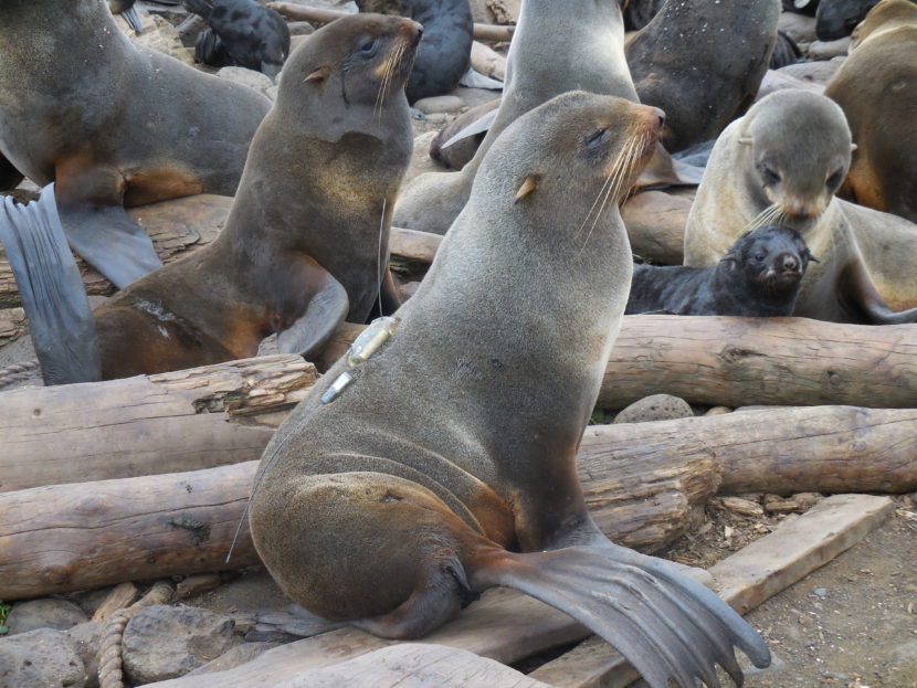
The northern fur seals on St. Paul Island are one of the most-studied marine mammals on the planet, but there’s still a lot scientists don’t know.

For the first time this year, scientists are using a device called a Saildrone to track down more information about the seals. The tool could help solve the mystery of why fur seals on the island have been declining since the 1970s.

Scientists have been tagging fur seals to monitor their foraging trips since the early 1970s. This year, they’ve added a new device: the Saildrone. Ecologist Carey Kuhn says the unmanned, wind- and solar-powered contraption can patrol the Bering Sea and measure the amount of available prey.

“We haven’t had the ability to take a boat out and do these types of large-scale prey surveys during the summer months when we want to know what’s going on,” said Kuhn. “The Saildrone has just been groundbreaking for us.”

Imagine the ocean has a bunch of different grocery stores. In the past, scientists could see which stores the seals were visiting, but they couldn’t see what was in them. Scientists can program the Saildrones to visit the feeding areas fur seals are known to frequent and log how much and what kind of fish are there.

https://vimeo.com/167481038

The summer months are especially important, when fur seal moms try to fatten their pups up for the winter. Different seals have different strategies. This year, Kuhn saw one mother who hunted for six days, traveling more than 160 miles north of St. Paul.

“We know that when an animal spends a longer period of time at sea, the pup spends a longer period of time fasting on shore,” she said. “Then its growth rate isn’t as high as a female who could return quickly and feed her pup more often.”

At the end of the month, Kuhn will return to St. Paul to retrieve the seal tags and weigh and measure the pups.

When all the data is in, the team will be able to see where the seals are getting their food and how much there was. Kuhn says those answers are made possible by Saildrones.

“We really think this is going to change the way that we do science because we’ll be able to do things that we haven’t had the ability to do in the past,” she said.

Kuhn says this is the first step of a larger project. Understanding how northern fur seals respond to changes in the distribution and abundance of fish could explain the mysterious decline of fur seals in the Pribilof Islands.

Alaska prepares for vessel disasters

A helicopter practices dropping an Emergency Towing System on the Coast Guard cutter Morgenthau. (Zoe Sobel/KUCB)

On one of the nicest days of the summer, the Coast Guard cutter Morgenthau needs help. The boat is playing the role of distressed vessel. A local tug slowly approaches its bow while crew members ready the Emergency Tow System. Horns blare and bang. One end of the rope is on the tug and the other on the Morgenthau. On both sides, people scramble to secure the lines for towing.

Coast Guard Lt. Andres Ayure is coordinating the drill. He says the practice helps ensure everything is in working order.

“If you don’t exercise it yearly, then with some time, some of these components could start decaying or start to break down,” Ayure said. “We wouldn’t find out until we have an actual emergency, which is not when we want to find out.”

The city purchased its first Emergency Towing System after the 2004 grounding of the Selendang Ayu. When that ship split in half in rough seas off Unalaska’s coast, six people died and thousands of gallons of oil spilled in sensitive coastal habitat

If you ask conservation biologist Rick Steiner, it’s only a matter of time before the next disaster.

“After that you’ll see all these politicians and people running around in their orange suits, clipboards and hardhats saying we need to do something better,” Steiner said. “All of that will be useless at that point.”

As a member of the Shipping Safety Partnership, Steiner has helped institute some improvements in boating safety since the Selendang Ayu’s grounding. The Marine Exchange of Alaska has added more than 100 monitors to track boats 24 hours a day. Last year, the International Maritime Organization approved shipping buffer zones in the Aleutians to keep vessels further from shore.

But Steiner says there’s still a lot to do. He wants better navigation aids, increased financial liability for shippers, and, most important, all-weather rescue tugs.

Members of the Coast Guard secure the Emergency Towing System. (Zoe Sobel/ KUCB)

“Let’s say you get this portable tow package on the bow of a disabled tanker out at Shemya,” he said. “What then? You don’t have an adequate rescue tug of open ocean, powerful thrust and capability to actually hook it and render ‘a save’ in most scenarios.”

Steiner says the smaller, less busy Prince William Sound has 11 tugs. He’d be happy with three for the Aleutians and he wants to use the $5 billion Oil Spill Liability Trust Fund to pay for them.

It’s impossible to eliminate all risk, but Steiner says preventative measures, like buying tugs, would be economical. Oil spills are expensive to clean up and not very effective.

Ed Page knows about the cost of oil spills firsthand. He spent 30 years in the Coast Guard, three of those cleaning up the Exxon Valdez spill.

“Three years, $2 billion, 10,000 people, picked up 10 percent,” Page said. “That’s not a very good return on investment. So you want to say it’s difficult, yeah, that’s almost an understatement. It’s almost an exercise in futility. You got to give it a shot. Picking up 10 percent is better than picking up nothing, but still, prevention is clearly the way to go. There’s no doubt.”

Cleaning up spills in the Aleutians or the Arctic would be even more costly.

Now Page heads up the Marine Exchange of Alaska which works to improve safety by monitoring the locations of vessels in Alaskan waters. He says the size of Alaska’s monitoring network is massive — 1.5 million square miles — larger than anywhere else in the world.

The statewide tracking system provides automatic alerts anytime a ship slows down or gets too close to shore.

But now Page says, larger vessels, some bigger than the Empire State Building, are traversing Alaskan waters. And he says, there are no boats powerful enough to save them.

“They’ve got 18,000 containers and they carry a tremendous amount of oil,” he said. “If you took the containers off the deck and lined them on the dock end-to-end, they would go 60 miles. If that vessel gets in trouble, there’s nobody who can give them a hand.”

The boats are too big to stop in Alaskan ports. Page says they’re only passing through, just like the Selendang Ayu.

The task of improving maritime safety is ongoing. Page says now they’re working on a new device — a parachute ship arrestor — that would work like a huge sea anchor to slow down and stabilize distressed vessels — providing more time for repairs or a rescue.

As waters warm, Arctic fish populations change

Arctic cod is an important part of the marine food web. (Photo courtesy of NOAA)

A new report shows more fish are moving to Arctic waters. The U.S. Geological Survey and the Bureau of Ocean Energy Management teamed up to create the inventory, which describes more than 100 species of fish found in the Chukchi and Beaufort Seas — including 20 species new to the region.

The Alaska Arctic Marine Fish Ecology Catalog for the Beaufort and Chukchi Seas has been a long time coming. Biologist Milton Love has been working on the project since 2009. He says both Arctic seas appear to be changing.

“We’re starting to see either new introductions of temperate fishes from the south or at least larger numbers of them, particularly in the Beaufort Sea,” said Love.

At this point, Love isn’t sure what these changes mean for fish traditionally found in the Arctic. Since the area has historically been difficult to sample, it’s hard to establish if fish are coming from the south, growing in population, or both.

One species that could be affected is Arctic cod, a major player in the marine food web. Love says the species does better in near-freezing water.

“If ice becomes less predominant over time and waters warm, then perhaps Arctic cod will not do as well,” he said. “There are a number of predatory birds and mammals that certainly feed in great quantity on Arctic cod.”

If those species aren’t able to eat anything else, they could be impacted, too.

Because of the importance of Arctic cod, the team analyzed the effects of a warming climate on the species as well as its major competitor – saffron cod. As temperatures rise, both species will likely shift north. That would expand the range for saffron cod, but restrict the range for Arctic cod.

Love sees a wide range of uses for the new report, from evaluating environmental impacts on the region to monitoring changes in fish distribution and managing fisheries. It also includes traditional Iñupiaq names to improve communication between researchers and local communities.

New 3-D map will help monitor climate change in Alaska

The digital elevation models show the unique boreal forest vegetation patterns alongside the Koyukuk river. (NSF/NGA)
The digital elevation models show the unique boreal forest vegetation patterns alongside Western Alaska’s Koyukuk river. (NSF/NGA)

In Kotzebue a year ago, President Barack Obama called for a publicly available, high-resolution elevation map of Alaska, a map that will help Alaskans monitor the effects of climate change. Now, it’s here.

There are many satellites that orbit the Earth. Typical satellites — like NASA’s Landsat — capture really large images, more than 100 miles across. For this project, the images are much smaller.

Paul Morin, director of the Polar Geospatial Center, says these satellites function like human eyes to help make the 3-D images.

“You can tell when things are close and far away because you have two eyes and they’re separated,” Morin said. “That’s pretty much the same principle, and instead of having two satellites, you have one satellite and it takes two pictures.”

Once there are two good images, those pictures are fed through a super computer. Software is used to find the same objects in both images. From that, the elevation is calculated.

Kenai Peninsula's Wolverine Glacier. (NSF/NGA)
Wolverine Glacier is on the Kenai Peninsula. (NSF/NGA)

Morin says the elevation maps are available online and can document landscape changes.

“It can be used to look at the gain and loss of ice on a glacier,” he said. “It can be used to calculate the extent of watersheds for a lake or for a river.”

Topography on this scale is so detailed it can measure individual trees.

“We have such resolution in this data that people can go in, look at an elevation data set from two years ago and compare it with a data set from today,” Morin said. “And you can see individual trees being cut down.”

Collecting the imagery for this project has taken three years. Now that Alaska is completed, up next is the entire Arctic. Those maps are expected to be finished by the end of 2017.

Should Alaskans fear diseases frozen in the permafrost?

Coastal erosion reveals the extent of ice-rich permafrost underlying active layer in the Teshekpuk Lake special area of Alaska's National Petroleum Reserve . (Photo: Brandt Meixell/USGS)
Coastal erosion reveals the extent of ice-rich permafrost underlying the active layer in the Teshekpuk Lake special area of Alaska’s National Petroleum Reserve. (Photo: Brandt Meixell/USGS)

Russian officials say warming permafrost could be linked to a deadly anthrax outbreak in Siberia this month.

Permafrost can be found almost everywhere in Alaska — from the Arctic coast to Anchorage.

But at least one expert isn’t alarmed about the potential for thawing ground to bring old diseases back to life.

After a Siberian heat wave, anthrax hit the Yamal Peninsula in early August.

The bacterial disease has claimed the life of a child and thousands of reindeer.

Permafrost expert Vladimir Romanovsky of the University of Alaska Fairbanks said melting permafrost and erosion may have worked together to spread anthrax into the water supply.

“Thawing of permafrost can release microorganisms first into the active layer, then into water and air,” Romanovsky said. “They were sequestered there for many, many years — tens of years, even thousands and tens of thousands of years.”

Scientists have talked about the possibility of epidemics caused by thawing permafrost, but until now, it’s only been a theory, Romanovsky said.

If the Siberian anthrax outbreak is traced back to spores in the permafrost, then it would be a troubling development.

“This release of these dangerous microorganisms could actually be spread very easily from the north, because we have lots of birds who are migrating all kind of places in the world,” he said. “So this problem could be not just local problem. It could be global problem.”

More research is needed to tie this anthrax outbreak to warming permafrost, Romanovsky said.

Infectious disease specialist Dr. David Morens, with the National Institutes of Health, isn’t worried about anthrax — or any other disease — surfacing from the ground.

Anthrax is hardy and virtually everywhere, he said.

“Anthrax is sitting in the grass in farms in Texas,” Morens said. “It’s in Asia. It’s in Africa. It’s everywhere. And so the fact that some might be in the permafrost doesn’t really add to whatever the risk is.”

Although anthrax is widespread, the chance of getting sick from it is really small.

The likelihood of contracting anthrax from spores exhumed from the permafrost, is even tinier.

Morens has studied the 1918 Spanish influenza pandemic that decimated rural villages in Alaska. Brevig Mission was hit especially hard.

Spanish flu killed 90 percent of the village over the course of six days.

The remains of victims were buried together.

Researchers have used samples from that mass grave to reconstruct the genetic code of the virus.

But Alaskans shouldn’t be afraid of getting sick as the ground in Brevig Mission thaws, Morens said. Unlike anthrax, Spanish flu is very fragile.

“What came out of the so-called permafrost was just broken pieces of RNA,” Morens said. “Nucleic acid. There was nothing infectious. A ton of it swallowed would have been harmless.”

Freezing and thawing breaks up viruses like Spanish flu, killing them.

“So if we are talking about viruses and deadly things, I would say whatever might be there in the permafrost is not going to be contagious,” he said.

Morens doesn’t fear viruses or bacteria emerging from their cryogenic slumber, but he is concerned about the threat of new diseases.

“All these emerging viruses that are coming on — Zika, chikungunya, severe acute respiratory syndrome (SARS), and all that,” Morens said. “It’s not that they’re being created. It’s not that they’re being dug up from the permafrost. They’re already there. And we human beings do things that invite them to come in, infect us, and cause epidemics.”

Officials in Russia are trying to stop the anthrax outbreak from spreading further. They are incinerating all infected reindeer carcasses and have banned hunting in the region.

Trawling the ocean floor, scientists discover new snailfish

Snailfish can be hard to distinguish. The combed snailfish (top) is found in the Aleutian Islands and the comet snailfish (bottom) lives in the Bering Sea. (Courtesy Jay Orr/NOAA)

While trawling the floor of the Bering Sea and the Aleutian region, scientists have discovered several new species of fish — snailfish. Some were only named last year. Researchers were not looking for them, the trawl was a part of a yearly stock assessment by the federal government that helps set quotas for fisheries.

Snailfish look like overweight tadpoles. They don’t have scales, making them easy to damage. Biologist Jay Orr, of the National Oceanic and Atmospheric Association, says that partly explains why there are so many unnamed species.

“When they come up in the trawls that we use to sample the bottom,” Orr said. “They are tossed about in the nets and pretty well torn up by the time they get to the deck where we do our sorting work.”

But really, the different species are just hard to distinguish. Orr thinks scientists might have avoided identifying them and called all snailfish, snailfish. Now with a special bag attached to the trawl, it’s easier to collect the fish undamaged.

“I was able to see them alive, in good shape and full color.” Orr said. “And began to realize we were seeing different species. And I began to realize we hadn’t seen these species before.”

From the Arctic to Antarctica, there are more than 350 different types of snailfish that live in a variety of environments — from shallow tide pools to the depths of the Marianas Trench. That’s more than four miles below the ocean’s surface, making snailfish the deepest known swimmers in the vertebrate world.

Orr says a lot is still unknown. But it’s important to study snailfish to improve our inventory of the ocean environment.

“To understand biodiversity of the system is to understand how many species are actually out there,” he said. “We can’t really begin to manage the ecosystem until we understand what pieces are there.”

With 86 species of snailfish known to live in Alaska so far, it’s a complex picture for scientists to piece together. But Orr is up to the task. Over his career, he’s discovered 26 different species of snailfish. About a dozen of those still need names.

And now, he’s starting work on a new project — identifying the evolutionary relationships of North Pacific snailfish and piecing together their place in the global snailfish family.

Site notifications
Update notification options
Subscribe to notifications