Western

Gov. Dunleavy says state taking stock of damage from historic Western Alaska storm

A house sits in floodwater surrounded by debris
Major flooding in Hooper Bay on Saturday. (Photo courtesy of Lola Cernek)

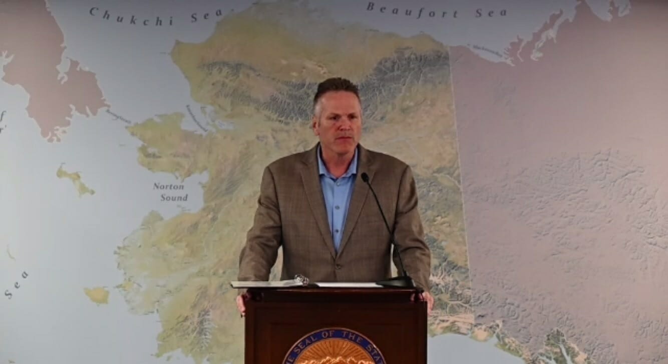
Gov. Mike Dunleavy said Saturday night that this weekend’s historic storm has impacted almost 1,000 miles of Alaska’s coastline, and it continues to batter the state.

He said that state officials have not yet gotten reports of any storm-related injuries or deaths.

“We’re trying to assess exactly what has occurred,” Dunleavy said at an 8 p.m. news conference. “We’ve got a lot of rain. We’ve got wind. And we’ve got surge — storm surge — is going to be the big concern.”

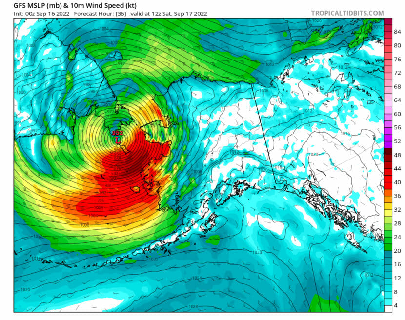
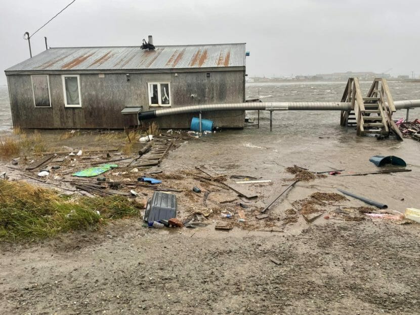
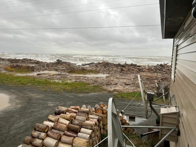
The powerful storm, remnants of Typhoon Merbok, slammed into Western Alaska Friday night, hitting the Lower Kuskokwim area and moving north along the Norton Sound region. It led to widespread flooding and damage, with seas as high as 50 feet and hurricane-force wind gusts up to 90 mph. Communities around Nome and further north are expected to feel their biggest impacts overnight into Sunday, said Dunleavy.

“So folks in Kivalina, places like Deering, even Point Hope, just need to be on alert and make sure they’ve got their personal belongings stored as well as possible and are seeking, if possible, higher land,” said Dunleavy.

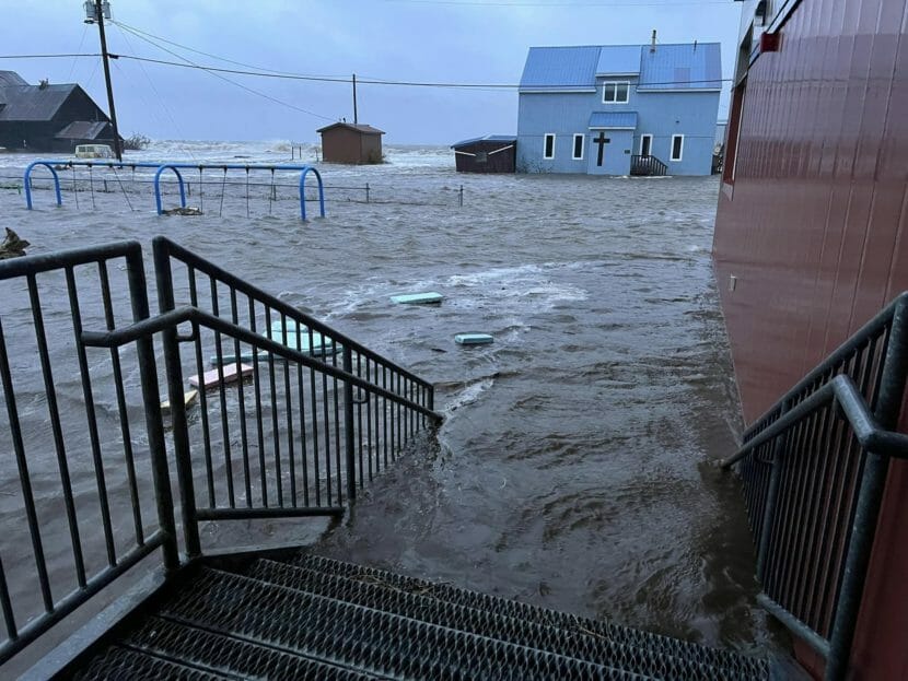
In Shaktoolik, about 125 miles east of Nome, residents said Saturday they were bracing for another storm surge that night, worried after the first completely destroyed the berm that protects them from the sea.

“The state has been in contact with us and they say the worst is yet to come,” Mayor Lars Sookiayak said in an interview Saturday. “So we don’t know what to expect.”

Seen from next to a house, wood and debris piled up at the edge of an angry sea
The storm destroyed Shaktoolik’s berm, all that stands between the village and the salt-water waves. (Photo courtesy of Gloria Andrew)

Sookiayak told the community’s roughly 220 residents to evacuate to the school or a local health clinic early Saturday. The Red Cross reports at least 450 Alaskans are currently sheltering at local schools across multiple communities. Dunleavy said none have been evacuated out of their communities yet.

Dunleavy issued a disaster declaration Saturday morning in response to the storm, and said the state needs to move quickly to assess and respond to the damage, with freeze-up likely just a few weeks away in the more northern areas. He said the state is in contact with the federal government.

“We just have to impress upon our federal friends that it’s not a Florida situation where we’ve got months to work on this,” he said at the news conference. “We’ve got several weeks to work on this.”

Gov. Dunleavy stands at a lectern in front of a map of Alaska
Alaska Gov. Mike Dunleavy speaks during a press conference on a massive storm affecting Western Alaska on Saturday, Sept. 17, 2022. (From Gov. Mike Dunleavy’s office)

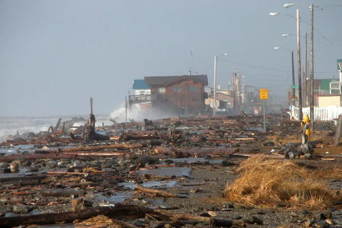
Dunleavy said the state knows there has been significant flooding, plus damage to roads, homes and fuel storage in numerous communities. He said there’s also possible damage to airports, ports, seawalls and water and sewage systems. Among the challenges is that the destruction covers hundreds of miles and dozens of communities, each likely with a unique set of damages and recovery needs.

“It would be something akin to parts of Florida being impacted, Georgia, South Carolina and maybe even further points further north,” he said.

Another reason the assessments need to be done quickly, Dunleavy said, is because the state is tracking another typhoon that’s approaching Japan. If the typhoon’s remnants again move toward Alaska, the storm could land in about seven to 10 days, he said.

“We’re going to keep an eye on that as well,” he said. “But we’re going to move very quickly to do everything we can to get our communities assessed.”

Bryan Fisher, director of the state Division of Homeland Security and Emergency Management, said, so far, the state knows that the Aleutian and Pribilof islands did not see major damage, and commercial fishing fleets had enough warning to get to safety. He said the significant storm impacts started as far up the Kuskokwim River as Bethel, 66 miles inland, and then moved up the western coast and to the Norton Sound.

“This storm is going to be with us for a while. The impacts are going to be felt above Nome, up to Kotzebue and Kotzebue Sound, and communities north,” he said. “So we’re continuing to communicate all day with the communities out there.”

It’s likely the military will be involved in the state’s response to the storm, said Maj. Gen. Torrence Saxe, commissioner with the Alaska Department of Military and Veterans Affairs. He said on Saturday the focus was asking Western Alaska communities about immediate needs.

“Because we are quite literally in the midst of a storm, we are asking the question, ‘What do you need? What do you anticipate you’re going to need?’” he said. “Now all the phone calls today we asked the question, ‘Do you have any injuries?’ ‘None.’ ‘Do you need medical help?’ ‘None.’ But that could change.”

The state is also going to continue to assess whether communities have the food and drinking water that they need.

“We’re assessing everything,” said Dunleavy. “So we’re prepared to deal with this and make these communities whole.”

He also underscored that the National Weather Service’s ability to forecast earlier in the week that the typhoon’s remnants would hit Alaska was hugely helpful.

“I think people did prepare, but you can’t prevent a tropical storm or the remnants of a typhoon — you can’t prevent that from happening,” he said.

Dunleavy said he expects the state to have a better idea by Sunday about the storm’s impacts.

For more on the storm, visit Alaska Public Media’s live blog.

Powerful storm brings widespread damage to Western Alaska: ‘I’ve never seen the water this high’

A photo from the steps of a buildings showing water inundating a community, including a church in the background
A massive storm battering Western Alaska brought floodwaters to the steps of the local school in Golovin on Saturday. (Courtesy Josephine Daniels)

A powerful storm is slamming Western Alaska, with reports of major flooding, high winds and widespread damage in numerous coastal communities.

Gov. Mike Dunleavy declared a disaster for the communities impacted by the storm Saturday morning. By Saturday evening, the state said it had received no reports of injuries or deaths related to the storm.

But damage had torn across hundreds of miles of Alaska’s coastline impacting communities all along the way. Alaskans described water flooding homes and roads. Wind tore off roofs. Houses floated off their foundations. Boats sank.

The water has begun receding in many areas, but further north, the peak of the storm surge is forecast to hit later Saturday night. As levels drop, more damage will be revealed.

Worst storm in living memory

In Hooper Bay, 110 people were sheltering at the school on Saturday morning, according to Vice Principal Brittany Taraba.

Tribal Chief Edgar Tall said at least three houses had moved off their foundations. He said he’s never seen a storm like this.

“Not in my whole life,” Tall said. “Some people that are older than me, since they were children.”

In a video recorded Friday in Hooper Bay, 63-year-old Judy Bunyon also said it was the worst storm she’d seen since childhood. The video showed water flooding homes and wind tearing off roofs. 

In Golovin, Josephine Daniels said she and many other residents were forced from their homes as waters rose Friday evening.

“The storm started to get halfway up the beach around 6 p.m. last night,” Daniels said. “So we moved to the school. Then when we woke up, the water was covering some of the steps at the school — the school is in the center of the village downtown.”

Late Saturday morning, Daniels said the water had stopped rising. The school and everyone inside appeared to be safe, but the building was “still surrounded by water.”

In Chevak, City Administrator Dennis James said the community had lost most of its fishing fleet.

“There are multiple boats and motors that sunk and these are our livelihood — equipment for the livelihood of the people,” he said. “It’s pretty devastating to witness something like this.”

More than 15 families had sought emergency shelter overnight. No injuries were reported locally, but a third of the village had lost power amid extensive damage.

“We’re situated on a bluff, and that’s probably the only saving grace for our community,” James said. “I’ve seen it flooded over to where it looked like we’re on an island, but I’ve never seen the water this high before.”

In Newtok, part of the town is flooded and dozens of people are staying at the school. Joseph John, who works at the town store, said about nine or 10 houses had flooded, and the riverbank eroded between 10 and 20 feet overnight.

Erosion has long threatened Newtok. For decades, the community has been laying plans and securing funds to relocate the entire village to more stable ground.

About a third of the community has relocated to Mertarvik, a new village site nine river miles upstream from Newtok. The rest of the community is expected to move there in the coming years as more homes are built.

John’s main concern now is how much water is going to come back in with the next high tide.

“This is the worst we’ve had in years,” John said.

National Weather Service hydrologist Johnse Ostman said Kuskokwim Delta villages are seeing are also seeing flooding, including Napakiak, Oscarville and Napaskiak. In Bethel, Brown’s Slough has flooded parts of the east side of the city.

Ostman said the National Weather Service also believes there has been flooding in Lower Yukon Delta communities. 

He said that most communities in the Yukon-Kuskokwim Delta should see water begin to recede, but coastal communities can still expect to see high surf.

But Ostman said people should be cautious even as high water recedes. Some places will experience ponding of deeper water, and sinkholes could form under water that appears to be shallow.

‘We’re not done’

University of Alaska Fairbanks climatologist Rick Thoman said Saturday morning that reported damage from the storm was both widespread and intense.

“Nome has just – the water level there has just gone to 10.3 feet, which now makes us the highest water level in Nome since the Great 1974 Storm,” he said. “Obviously, just tremendous damage in Golovin.”

https://twitter.com/AlaskaWx/status/1571185552950689793

With water levels still rising Saturday in the northern Bering Sea, Thoman warned that “we’re not done” with the storm, with further flooding expected in Shishmaref and Kotzebue along the Chukchi Sea — and in Nome, as water keeps moving east into Norton Sound.

Thoman said that one of the more striking aspects of the storm, from a climate perspective, was its arrival so early during Alaska’s winter storm season.

“It’s not that storms this strong don’t happen, but they occur later when there’s larger temperature differences across the region,” he said. And that’s a function in part of this being ex-Typhoon Merbok.”

Early Saturday afternoon, the National Weather Service said the storm was continuing its trajectory up the western coast of Alaska, and the center of the storm was now above the Diomede Islands in the Bering Strait.

Ostman said this storm has been historic in Alaska because of how far north Typhoon Merbok developed.

“These tropical cyclones typically are further south,” Ostman said. “This one developed much higher and was able to track further north.”

Forecasters’ worst-case scenario

National Weather Service climatologist Brian Brettschneider said the reality was like forecasters’ “worst-case scenario.” 

“All those ingredients really did come together this time to create just the unique set of circumstances to maximize the amount of damage,” Brettschneider said. “So not only the strength of the storm, but the trajectory and what we call the fetch, how long the winds are blowing at just the right direction to push water right into vulnerable coastal locations.”

Brettschneider said the scale of the affected region is massive. And the storm slowed as it approached Alaska, intensifying the surges of water it drove ashore.

“High water will be our problem for much of the day,” he said.

Brettschneider said forecasters were able to provide detailed warnings of the storm’s impact in the days leading up to Friday due to remarkably accurate computer modeling of Typhoon Merbok’s collapse during the past week.

“It’s really kind of an impressive display of computational power that it was able to get the strength, the intensity, the direction and the potential impacts several days in advance,” he said. “In this case, you know, the storm is exactly where we thought it was going to be several days ago.”

This is a developing story. For the latest, visit AlaskaPublic.org

Editor’s note: If you live in a community impacted by the historic storm, we’d like to hear from you. If you’re interested in speaking with a reporter, please reach out: news@alaskapublic.org or 907-550-8444. Thank you.

Western Alaska braces for coastal flooding and 90 mph gusts from potentially historic storm

A storm tracking map showing an intense red area covering most of the Bering Sea
An aerial view of the incoming September storm on track to hit Western Alaska today and tomorrow. (Storm track from Rick Thoman with UAF ACCAP, Aug. 16, 2022)

As a significant fall storm approaches Western Alaska, the state Department of Homeland Security and Emergency Management is asking residents to prepare as best they can to protect life and property.

What’s left of Typhoon Merbok is on a textbook track into the Bering Strait, said Ed Plumb, a meteorologist with the National Weather Service Office in Fairbanks.

“The remnants of that [moved] up into the Bering Sea Thursday, and then move northeast and track towards the Bering Strait,” Plumb said, “And then into the Chukchi Sea through Saturday.”

Thursday night, seas were as high as 41 feet in the Western Aleutians, according to the National Weather Service in Anchorage.

Because the storm is estimated to bring high winds and coastal flooding later today, DHSEM is urging communities and residents to make last minute preparations now. Claude Denver, the response manager for the state emergency operations center, said people in Western Alaskan should secure large equipment or loose materials, stock up on drinking water and check on their neighbors in need.

“We expect that there may be up to 90 mph gusts. The same kind of weather conditions that would complicate flying, would complicate any kind of aerial delivery of materials or response. So that’s something to keep in mind. For most communities, while the storm is going on, folks have to employ your local emergency plans in preparation to kind of get through the first 48 to 72 hours of the event,” Denver said.

The strongest wind gusts are expected later tonight along with rapidly increasing storm surge throughout the night.

https://twitter.com/AlaskaWx/status/1570844633458155520?s=20&t=uek9G_8O2K4vbYnU8yS_JA

This applies to communities along the Yukon Delta Coast, the Norton Sound, and throughout the Bering Strait. The peak storm surge could rival the Bering Sea superstorm from November of 2011. But without any sea ice to buffer coastal communities this time around, Plumb says it could cause severe coastal flooding.

“The highest storm surge is going to be in the Northern Bering Sea. We’re looking at storm surge values from 8 to 12 feet over portions of the Southern Seward Peninsula and then down further south, towards the Yukon Delta, 5 to 8 feet,” Plumb said.

Based on historical climate records in Alaska, going back over the last hundred years, this could be the strongest September storm ever recorded in the Northern Bering Sea, according to NWS.

Denver emphasizes that for now, communities should activate their emergency response plans. But once the storm settles down, then the state will respond with the appropriate resources, Denver said.

“We’re really not quite sure what the impact is going to be,” Denver said. “So we really want to make sure that if something happens in a community, if they could reach out to us, the State Emergency Operations Center at (907)428-7100, and let us know what they find; if there’s flooding, if there’s damage, [high] winds, resource needs, if they’ve got people sheltering, if the power is out.”

For more detailed information on what local impacts this storm could have in your community, go online to NWS Fairbanks’ Facebook page.

Storm of the decade forecast for Bering Strait region

Front street in Nome, soaked and covered with debris
The aftermath of the infamous storm that ravaged Nome and environs in October 2004. Here is the east end of Nome’s Front Street just after the storm had passed, littered with driftwood and large rocks. KNOM provided live coverage and emergency advisories throughout the event. (Photo from KNOM file, 2004).

The National Weather Service is forecasting coastal flooding in Nome and across Western Alaska this weekend, with potential storm surge reaching up to 14 feet above normal levels. If this multi-day fall storm hits Western Alaska as predicted, storm surge would reach levels rarely seen over the last 50 years.

Based on the latest forecast from the Weather Service office in Fairbanks, significant storm surge and high wind will affect the coast of Western Alaska from Point Hope south to Hooper Bay starting tomorrow.

The Weather Service currently estimates water levels will rise between eight and 11 feet above normal high tides in the Nome area, with the likelihood of the Council Road being completely covered in water.

The forecast also calls for powerful winds along the Bering Sea coast, with gusts as high as 90 mph possible in some places.

The storm could be just as damaging as the November, 2011 Bering Sea superstorm and have similar coastal flood impacts, according to the Weather Service. The City of Nome announced on social media that the residents in Belmont Point area should be prepared to evacuate if necessary.

Climatologist Rick Thoman with the Alaska Center for Climate Assessment and Policy at the University of Alaska Fairbanks told KNOM via email that the latest information suggests Nome will see some of the highest ocean levels ever recorded since the local sea wall was constructed. Nome’s seawall was completed in June of 1951, according to the U.S. Army Corps of Engineers, but updated to something similar to its current form in the mid-1970s.

https://twitter.com/AlaskaWx/status/1570481928813551616


Thoman said that the timing of tides and the highest storm surges will determine where coastal flooding will be the most severe.

“Coastal flooding is certain this weekend, the only question is how bad,” he said.

Even the UAF research vessel Sikuliaq, which was docked in Nome the afternoon of Sept. 14, left town and headed north ahead of schedule to avoid the worst of the storm.

This post has been updated.

Watch: With the salmon collapse on the Yukon River, families are losing a vital food source and way of life

For the second year in a row, a severe and sudden salmon collapse has affected Indigenous residents on the Yukon River. Subsistence fishing for the two main salmon species, king and chum, has been closed for two summers due to record low runs. Residents of traditional villages are now facing food insecurity because of the collapse. Now, the Indigenous communities on the river whose ways of life have revolved around the fish for thousands of years are also facing a devastating loss of culture. Olivia Ebertz reports from the Lower Yukon.

Climate change has made fuel safety inspections in the Y-K Delta more important than ever

A person on an ATV points at a set of fuel tanks on the tundra
The goal of the fuel inspections is simple: prevent a catastrophic oil spill that would make its way into Y-K Delta rivers, devastate the ecosystem, and threaten a subsistence lifestyle. (Photo by Nate Littlejohn/U.S. Coast Guard Anchorage Sector)

The U.S. Coast Guard recently completed a series of fuel tank safety inspections in communities across the Yukon-Kuskokwim Delta. In the face of climate change, these checks are becoming all the more important as the land beneath the tanks melts.

The goal of the fuel inspections is simple: prevent a catastrophic oil spill that would make its way into Y-K Delta rivers, devastate the ecosystem and threaten a subsistence lifestyle.

In large part, villages were found to be following best practices to prevent oil spills. Most of the issues that the inspectors identified were administrative, like having a written plan for how to respond to a potential oil spill.

“Staying in compliance with things like paperwork may seem extremely tedious, and it is, but it’s really not about the paperwork,” said Petty Officer 1st Class Nate Littlejohn, who works with the Coast Guard’s Anchorage sector. “It’s about getting together and talking about how you would respond to a spill with your community.”

The coast guard conducts semi-annual checks of bulk fuel facilities in Bethel and surrounding communities. In their most recent deployment during the last week of August, Coast Guard and EPA inspectors visited two dozen communities.

The investigators check to make sure that fuel storage facilities have the right containment measures in place, that there’s a system to respond to a spill, and that communities have appropriate equipment to do so. These failsafes are becoming increasingly important as the land that fuel tanks sit on becomes more unstable.

Climate change is creating a series of long term problems that threaten the security of fuel tanks and could cause spills down the line. As the region warms and permafrost begins to melt, the foundations upon which many of these fuel storage tanks sit have begun to slowly sink. According to Littlejohn, in some cases they are already seeing fuel tanks sitting at an angle because of permafrost thaw.

“The aging infrastructure combined with a changing climate is continuing to be a problem,” Littlejohn said. “And we’re absolutely going to see more spills if a solution isn’t provided.”

As the foundations of these storage facilities shift, Littlejohn said that it’s all the more important for communities to inspect them regularly, work to keep them level, and develop design adaptations that take climate change and permafrost thaw into account.

The region is not equipped to handle a catastrophic spill. If that were to happen, it wouldn’t just take an environmental toll. It would also immediately put human lives at risk.

“If thousands of gallons of heating oil are lost in the dead of winter, we have to come up with a solution for how that heating oil is going to be replaced,” Littlejohn said. “How are these folks going to heat their homes? That’s a big concern.”

The Coast Guard intends to return for another round of inspections next year.

Site notifications
Update notification options
Subscribe to notifications