Weather

As Climate Changes, Meteorologists Relying Less on ‘Using the Past to Inform the Future’

The National Weather Service has kept records for than a century on Alaska's weather, but Thoman relies on more recent trends for his 2016-17 winter forecast: the past 10 years of temperature data and 15 years of precipitation data. The data suggest there will be less precipitation next month in the Interior but more along the Arctic Ocean coast, and warmer temperatures..
The National Weather Service has kept records for than a century on Alaska’s weather, but Thoman relies on more recent trends for his 2016-17 winter forecast: the past 10 years of temperature data and 15 years of precipitation data. The data suggest there will be less precipitation next month in the Interior but more along the Arctic Ocean coast, and warmer temperatures.
(Courtesy National Weather Service)

National Weather Service meteorologist Rick Thoman predicts more snow, more cold snaps – more normal winter weather – in Alaska this year now that the El Niño phase that helped make last winter so mild has moved on and been replaced by a La Niña.

At least, that’s what’s happened in previous years. But he says climate change has made forecasting in the Arctic more challenging.

“Well, that is the big problem with using the past to inform the future,” Thoman said.

Experts such as John Walsh, chief scientist with the University of Alaska Fairbanks’ International Arctic Research Center, say climate change always must be taken into consideration when analyzing weather in the far north.

“No weather event is completely independent of climate change,” Walsh said in an interview last year.

Thoman says the weather service has pretty good data collected over the past 65 years on the so-called Pacific Decadal Oscillation, or PDO, cycle that drives El Niños and La Niñas.

But he says meteorologists are relying on data from recent years because climate change is a more recent phenomenon that’s made older data, collected before the Arctic began to warm so quickly, less relevant.

Thoman's "mid-winter" forecast, for November through January, also is based on more recent temperature and precipitation data. It calls for above-average snowfall in the Interior and continued above-average temperatures and snowfall along the Arctic Ocean coast.
Thoman’s “mid-winter” forecast, for November through January, also is based on more recent temperature and precipitation data. It calls for above-average snowfall in the Interior and continued above-average temperatures and snowfall along the Arctic Ocean coast.
(Courtesy National Weather Service)

“So it does shorten our record, and that’s bad, because then we wind up with fewer, say, La Niñas winters to develop these kinds of averages,” he said. “But the tradeoff is that we’re not including winters that are not really appropriate for what we have today.”

The size and location of a large body of warm water in the equatorial Pacific Ocean drive the transition from El Niño to La Niña. And Thoman says researchers are studying other phenomena that occur in lower latitudes that may play a role in La Niña. But he says in the Arctic, it’s the local factors that exert a more powerful influence on the region’s weather.

“The changes are happening so fast in the Arctic – with sea-ice loss, with increased time of no snow cover – that that’s really the driving feature. And the lower-latitude factors are being swamped those big cryosphere changes,” he said.

And because sea ice is sparse around Alaska, and snow comes later and melts sooner, Thoman says this winter is likely to be cooler and snowier than the past few winters. Still, he says it’ll be a relatively mild winter, compared with La Niña winters of years past, because the climate overall is warmer now.

Denali’s dogs: Protecting the environment and preserving heritage

In the winter, Denali's sled dogs ferry park employees through areas closed to motorized vehicles. (Zoë Sobel/KUCB)
In the winter, Denali’s sled dogs ferry park employees through areas closed to motorized vehicles. (Zoë Sobel/KUCB)

Early on a crisp, fall morning a large white truck sits alone in a dirt parking lot at Riley Creek Campground.

Denali kennel manager Jennifer Raffaeli takes six huskies out of the van, fits them in harnesses, and hooks them to a line attached to a green metal cart that looks like a dune buggy. Raffaeli fastens her helmet.

On the trail, the only sound is the wheels whirring along the ground. The six-dog teams pull two humans around trails that wind in and around the campground.

On this day, each team is running about five miles, and then it’s back to the kennel. By the start of the winter season, the dogs will be doing 20-mile days. Over the course of the winter, they will log around 1,500 miles each.

It may seem backward, but Raffaeli says winter is the easiest time to move cargo through the park.

“Swamps and bogs and thick brush are the norm across Alaska,” said Raffaeli. “That’s challenging and slow going, especially if you are trying to move big heavy objects. When the park is covered with snow and rivers are frozen, you can carry huge loads because you’re not trying to carry them on your back. You’re sliding them over snow and ice, and that’s no problem for these guys.”

Pound-for-pound, Raffaeli says sled dogs are the strongest draft animals on the planet. That makes them the perfect tools for transportation through Denali’s designated wilderness — areas of the park that prohibit motorized vehicles.

Jennifer Raffaeli plays with the kennel's newest members. (Zoë Sobel/KUCB)
Jennifer Raffaeli plays with the kennel’s newest members. (Zoë Sobel/KUCB)

Dogs have been a part of Denali for the entire history of the park. In 1921, Harry Karstens was hired as the park’s first superintendent and insisted on having dogs.

“It made perfect sense as you created a two-million-acre park, which is a huge area to try and cover as one person. You were going to need some dog teams to cover that,” she said.

Back then, Raffaeli says dogs were the only way rangers could traverse the park and protect wildlife, like caribou and Dall sheep, from poaching. But over the years, the role of Denali’s sled dogs has changed.

In 1980, the Alaska National Interest Lands Conservation Act, or ANILCA, labeled the original two million acres of Denali as wilderness — the highest level of federal land protection — and gave renewed purpose to the park’s sled dogs.

The Wilderness Act requires that land managers look at the minimal tool for the task at hand,” Raffaeli said. “We’re always asking: Can we accomplish this project with dog teams?”

And if they can, they will. Over the winter, the teams are out for up to five weeks at a time. They haul supplies, support glacier research, and monitor man-made noise.

Plus, Raffaeli believes meeting a dog team in the field adds to the wilderness experience for park users.

“To encounter only a dog team on the trail — no snow machines, no other forms of motorized transport — is a form of peace and quiet and wildness that’s getting more and more rare,” she said. “It’s more and more valuable that we continue that heritage here.”

That’s a heritage that in many ways is fading. Denali’s huskies aren’t just the best method of winter transport. They help preserve what many people remember as daily life in Alaska.

But in a rapidly changing climate, Raffaeli is uncertain about the future of the dogs.

“If we start to get warmer winters with less snow, how does that affect the dogs?” Raffaeli said. “How do we evolve to face that new environment? I think those are really valid questions. But at the core of it all, I hope the dogs are always part of the story because they are such a special part of it.”

Back on the trail, the dogs are finishing their 30-minute morning workout. Raffaeli pulls into the campground parking lot and eases the team to a stop.

She jumps off and ladles water into one tin dog bowl after another. The dogs lap it up. When they are done, they go back in the van. It’s time for Raffaeli to get the next team ready for its five miles on the trail.

There’s no question, the dogs love their job.

How Is A 1,600-Year-Old Tree Weathering California’s Drought?

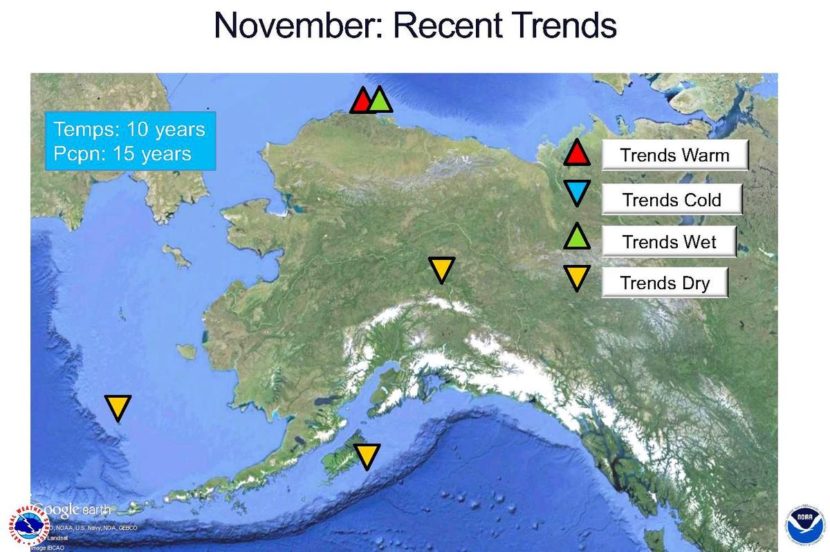
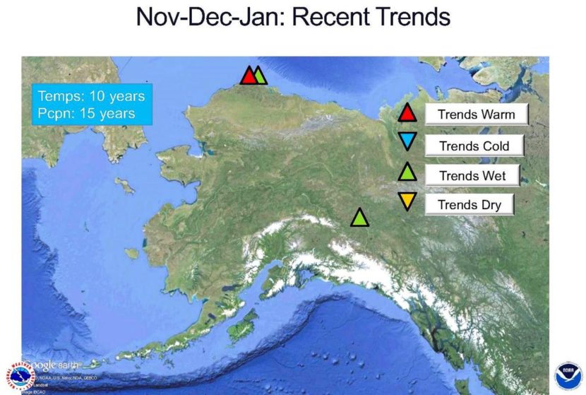
It’s been a brutal forest fire season in California. But there’s actually a greater threat to California’s trees — the state’s record-setting drought. The lack of water has killed at least 60 million trees in the past four years.

Scientists are struggling to understand which trees are most vulnerable to drought and how to keep the survivors alive. To that end, they’re sending human climbers and flying drones into the treetops, in a novel biological experiment.

From a distance, the forests of the Sierra Nevada look blotchy, with patches of dead trees standing right next to healthy green ones.

Nate Stephenson, an ecologist with the U.S. Geological Survey, says the drought and high heat combine to do things he hasn’t seen before. “We don’t really understand a lot of things,” he says, “like exactly how a drought kills a tree, or what’s going on underground. Where is the water flowing in areas we can’t see?”

Stephenson and his team of ecologists pull into a designated spot in the mountains, near Sequoia National Park, with truckloads of equipment they’ll have to carry in. Their mission: to find out what separates the surviving trees from the dead. Their ultimate destination is down a steep slope — through a blanket of pine needles, rotting tree limbs and a few yellow-jacket nests they are careful not to walk on.

The walk is worth it. Looming above is Odin, a green and thriving giant sequoia that’s more than 1,600 years old. The top is 250 feet up. Its base is as wide as a city street. Odin was a sapling when Rome was still an empire and, for some reason, it and many other sequoias are resisting this drought.

In hopes of finding clues to Odin’s survival, Cameron Williams, a researcher with the University of California, Berkeley, is heading up to the top.

“I consider myself a forest canopy biologist,” Williams says as he buckles on a climbing harness festooned with clips, carabiners, and an ascender — a kind of a clamp attached to the rope he will use to climb up.

He practices his emergency communication system: “Aaaaaaaaahhhhhhhhhhhhhhh,” he yells, then laughs. Williams can joke because he’s done this so many times. He and his climbing partner, Rikke Naesborg, also a research scientist at UC Berkeley, have spent hundreds of hours up in this tree. They take meticulous measurements, limb by limb, as though studying a patient etherized on a table. “Every single branch,” says Naesborg.

She takes notes dangling from the rope. “You get used to it,” she says. They check the tree’s growth rate, and how much moisture is in each branch and in the needles and cones.

“It’s very, very laborious,” Williams says.

Todd Dawson, the plant ecologist from UC Berkeley who is in charge of the expedition, says what’s happening to these forests is shocking and abnormal.

“There are a lot more dead trees in this forest than I’ve ever seen since we’ve been working here — since 2008,” Dawson says.

Dawson is like an epidemiologist — studying disease in a large population. In this case, the patients are trees. There are far too many to be able to climb each one, so while some members of the team take Odin’s measurements, Dawson is going to experiment with another approach. He’ll fly a drone around the giant sequoia — carefully avoiding branches on every side — and take detailed images.

“This is the first time for all of us,” says drone jockey Tom Jennings, who works for a company called CloudD8TA. “So we’re taking our time and trying to be very cautious. We’re dealing with the canopy, and that’s a new hazard that I’m not used to.”

The drones will fly to the top of the tree and then down around it in a spiral, taking many different sorts of images.

What the team hopes to do is compare what the climbers see with what the drones reveal. If drones can diagnose a tree as well as a climber can, they could cover a whole forest much faster.

The black drone rises from the ground, equipped with sophisticated cameras. It’s about 3-feet square and looks like something Darth Vader would have on his desk.

It records, basically, the reflected light off the canopy,” Dawson explains. “And that reflected light give us the health of the crown itself — water content and other chemicals like chlorophyll content, which is related to photosynthesis and nitrogen content.” These readings reflect how stressed the tree is.

As the drone slowly descends from the top of Odin, Williams pulls himself up the tree, on a rope the size of his pinky finger. He narrates his climb into a microphone clipped to his shirt.

“So we just reached 160ish feet above the ground,” Williams says. “Looks like a long way down there, and I can hear a drone overhead. Sounds like a giant bee’s nest. Looking around the landscape you can really see a lot of dead trees. Wow. There are hundreds — potentially thousands — of dead trees I can see in this one view.”

Already, from these sorts of measurements, Dawson has found that forests at low and mid-elevations — pine trees, fir, cedar — are suffering the most.

Drought and heat can choke a tree to death, scientists have found, by causing gas bubbles to form in the trunk, and block the flow of water. The stressed trees also close their stomata — the pores they respire through in the leaves and needles. That conserves moisture, but at a high cost. They can’t take in the carbon dioxide they need to survive. In other cases, beetles detect the weak trees and single them out — like predators taking wounded prey on the Serengeti.

So how are giant sequoias like Odin different? It could be that sequoias tend grow where there’s more groundwater, Dawson says. Or maybe it’s the way they shed needles when stressed.

Understanding how different species of trees respond is already helping scientists focus their rescue efforts.

For starters, you might thin the forest in places, removing some small trees and underbrush, Stephenson says. Having fewer straws sucking water out of the ground, means more water, more light and more nutrients for the biggest trees in the landscape, he says. And that would help the survivors weather future environmental stresses.

California’s current drought is disaster, but also a huge natural experiment, the forest ecologists say. Any lessons they can glean from studying Odin — going strong despite the drought — could help them save the rest of the forest.

Copyright 2016 NPR. To see more, visit http://www.npr.org/.

Ripinsky weather station provides data on mountain conditions

Snow caps Mount Ripinsky in Haines in November.
Snow caps Mount Ripinsky in Haines in November. (Photo by John S. Hagen)

If you’re heading into the mountains around Haines this winter, you’ll now have a better idea of what the conditions are like before going out. A weather station installed on Mt. Ripinsky last month is now transmitting data back to the web for anyone to use.

A volunteer crew helped carry around 200 pounds of equipment up Mt. Ripinsky on a sunny September day.

“We’ve been planning this project for about a year and the idea has been in the works for several years,” says Erik Stevens, director of the Haines Avalanche Information Center, which is affiliated with the Alaska Avalanche Information Center. With help from volunteers, he assembled the equipment into a weather station just below tree line at 2,600 ft.

“It’s an alpine weather station,” says Stevens. “It has temperature, wind speed and direction, rainfall and snow depth is what it measures.”

Then, that data is transmitted to the center’s website.

Stevens says the new weather station is useful for a few different reasons.

“One is just safety and preparedness,” says Stevens. “When you’re going out hiking or climbing or skiing on the mountain it’s really good to know what the conditions are like up there before you go out.”

It’s also important for avalanche forecasting.

“So it helps us kind of calibrate our forecast of what we expect to happen for the day and what we think happened overnight,” says Stevens.

There are three areas that the Haines Avalanche Information Center keeps an eye on.

“We call them forecast zones,” says Stevens. “They’re different because the climate is distinctly different in each of these areas. There’s still micro-climates within these areas but in general, the weather is pretty similar within each zone.”

The area closest to town is the Lutak Zone.

“And that’s basically a maritime area right above Haines,” says Stevens. “Mt. Ripinsky, Seven Mile Saddle, 3920, Tukgahgo, around Chilkoot Lake, that’s the Lutak Zone.”

That’s where the new weather station is. As you go further north there’s the Transitional Zone and the Chilkat Pass Zone.

“If you go a little more interior up the highway you get to the Transitional Zone,” says Stevens. “That includes Takhin Ridge, Old Faithful, Flour Mountain, Four Winds, that kind of interior area. Then if you keep going up into the pass, up into BC, that’s the Chilkat Pass Zone. And that’s a much more continental climate, a lot colder and windier, and often a lot more dangerous.”

Stevens says he hopes to eventually have weather stations covering all three forecasting areas. Avalanche information is important for safety. In this region, there have been five avalanche-related deaths in as many years.

“Ideally yeah, we would have a weather station in each zone,” says Stevens. “The more data the better. There’s also some data from the Palmer project. Constantine Mineral Resources has some data up the highway that we have access to. We’re definitely getting there. We’re much more data-rich then we were when we started out six years ago.”

This project was funded with grants from the Chilkat Valley Community Foundation and the Rasmuson Foundation, in addition to private donations of money and used equipment.

“We’ll be looking to upgrade that equipment and replace it as time goes on,” says Stevens. “But for now we’ve got something up and running and we’re really excited about that.”

Stevens says there could be some interruptions in the data going up on the website as they work out some technical issues. Otherwise, it’s all live on Alaskasnow.org.

No El Niño, but sparse sea ice, warm ocean water could mean near-normal 2016-17 winter

A year ago, National Weather Service meteorologist Rick Thoman and many other forecasters and climate researchers knew the winter of 2015-16 was going to be a warm one.

“We had warm sea-surface temperatures all around Alaska in the late fall,” Thoman said. “We had below-normal sea ice. And we had a strong El Niño.”

So, prognostications of the warm Arctic winter to come last year may be in hindsight as close to a no-brainer as it gets for the complex science of weather forecasting. And sure enough, the winter was the warmest on record, warmer than the previous record-setting winter and the unusually warm 2013 season.

A graphic of sea-surface temperatures, or SSTs, around Alaska shows some cooling over the past month in the Gulf of Alaska, but not so much in the Bering Sea. The scale at right shows the temperature-difference anomalies, compared with the norm, in Celsius.
(Public Domain image courtesy of the National Weather Service)

“Last year was pretty easy,” he said. “The climate dice were all loaded toward warm for Alaska.”

But not so this year, Thoman says, largely because the warm-weather-inducing El Niño has faded away and been replaced by a quirky La Nina.

“This year,” he said, “I’m going to have to work for my forecast.”

Thoman says La Niñas generally portend a cooler winter for Alaska, south of the Brook Range, and more precipitation for areas along and near the coasts. But he says that tendency is going to be somewhat moderated this winter, because a couple of factors left over from last year.

“We have continued warm sea-surface temperatures near Alaska, both in the Gulf of Alaska and in the Bering Sea,” Thoman said. He added the seawater isn’t quite as warm as last fall, especially in the Gulf of Alaska. But as for the other factor …

“We have even less sea ice near Alaska than we had last year, at this time.”

Sea-ice extent is one of several factors that climate scientists consider when formulating forecasts. There's less sea ice around Alaska than there was a year ago, but Thoman predicts the winter of 2016-17 will be cooler overall than last winter, largely due to the influence of a La Niña phase that's replaced the El Niño that helped make last winter the warmest on record in the Arctic.
Sea-ice extent is one of several factors that climate scientists consider when formulating forecasts. There’s less sea ice around Alaska than there was a year ago, but Thoman predicts the winter of 2016-17 will be cooler overall than last winter, largely due to the influence of a La Niña phase that’s replaced the El Niño that helped make last winter the warmest on record in the Arctic. (Public Domain image courtesy of the National Weather Service)

For those reasons, Thoman predicts the coming winter in the Arctic will be a bit warmer than normal – both here in Alaska and elsewhere around the region. But he concedes that forecast is mainly based on data from the past few decades when the circumpolar north began to warm at an extraordinary rate.

“Because conditions now are so different than they were, say, in the 1950s and ’60s, we don’t include those older (data), and start, say, in the mid-70s” for a more relevant set of data.

Next week: The challenges of Arctic weather forecasting in a warming climate.

Editor’s note: More information about climate change impact on Alaska is available through the Alaska Center for Climate Assessment and Policy.


Ask a climatologist: Will we have a snowy winter?

The first snow of the year in Anchorage, Oct. 21, 2016. (Photo by Rachel Waldholz/Alaska's Energy Desk)
The first snow of the year in Anchorage, Oct. 21, 2016. (Photo by Rachel Waldholz/Alaska’s Energy Desk)

Last week, Juneau saw its first snow before Fairbanks for the first time in some 70 years. With the exception of the Southern Kenai Peninsula and Southeast Alaska, the entire state is below normal for snow — from Anchorage to Fairbanks to Barrow.

That’s leaving a lot of Alaskans wondering, is this a sign of what’s to come?

Brian Brettschneider is a climatologist in Anchorage who closely tracks Alaska climate data and trends. Alaska’s Energy Desk is checking in with him regularly as part of the segment, Ask A Climatologist.

Brettschneider told me that the late snow doesn’t tell us much about what’s to come. In fact, you shouldn’t believe anyone who tells you they know what kind of snow year it’s going to be.


Brian: We can paint with broad brushes that we think it’s going to be a big precipitation winter, or we think it might be a low precipitation winter. But the shades of gray on that continuum are so large, that I’d really be hesitant — and I think most climate scientists would — to say one way or the other.

Rachel: So we can’t predict snow with any kind of confidence. Can we say anything about temperature?

Brian: Well, globally we’ve had month after month after month of record warm temperatures. Here in Alaska, we’re on track for by far our warmest year on record. So we would expect, given no other changes in atmospheric conditions, that we would continue well above normal. Now, we’ll throw a little caveat in there, and that is, NOAA has re-issued their La Nina watch. And typically, when there’s a La Nina, temperatures in Alaska trend toward the cooler side. So, if that does occur, we might expect some lower temperatures. But that’s far from certain.

Rachel: And if we do have a warm winter, does that tell us anything about the amount of snow we might see?

Brian: If you’re in a really marginal snow area, like Juneau or a lot of places in Southeast, where the difference between 30 and 35 degrees is the difference between snow and rain. Here in Anchorage and in much of mainland Alaska, the difference between, say, 25 and 30 degrees isn’t a snow or rain deciding line. It can be a more wet snow and or a more dry snow.

When temperatures are warmer, the air actually can hold a little bit more moisture, so in some cases you end up with more snow with a little bit warmer temperatures. But that doesn’t necessarily play out everywhere.

Rachel: So Alaskans who are wondering what the winter is going to look like are just going to have to wait and see?

Brian: I tell everyone who asks me — and a lot of people do ask me — “What’s the snow going to be like?” I won’t quite say, “Your guess is as good as mine.” But the probabilities are so difficult, it’s really kind of a fool’s errand to state one way or the other.

Do you have a climate question for Brian? Email akenergydesk@alaskapublic.org.

Site notifications
Update notification options
Subscribe to notifications