Weather

Hermine floods coastal areas in Florida before heading to Georgia

Brian Mugrage watches the weather on TV as he stands in the storm surge inside the Riverside Cafe in St. Marks, Fla., on Thursday. (Photo by Mark Wallheiser/Getty Images)

Updated at 10:15 a.m. ET

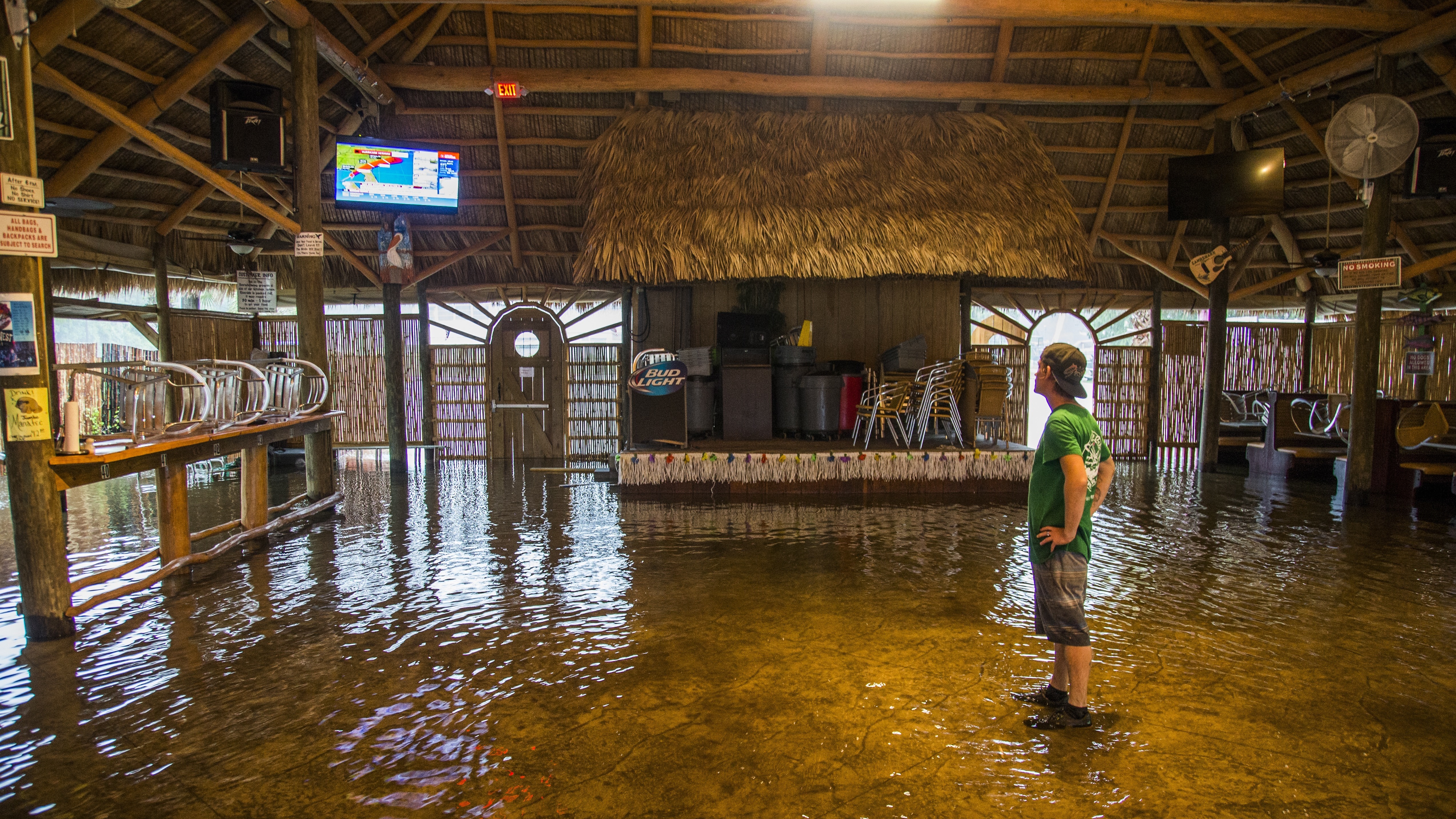
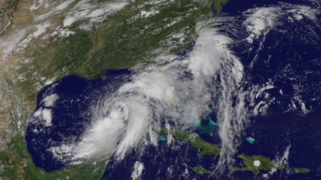
Hurricane Hermine made landfall early Friday morning just east of St. Marks, Fla., as a Category 1 storm with 80 mph winds, but weakened to a tropical storm as it moved further inland.

The National Hurricane Center expects Hermine to produce “a large extent of dangerous winds, life-threatening storm surge and flooding rains well to the east and southeast of the path of the center.”

The storm is expected to cross over southeastern Georgia during the day Friday, pass the coastal Carolinas overnight and move out over the Atlantic Ocean on Saturday, the National Hurricane Center says.

Florida Gov. Rick Scott said at least one person has died, killed when a tree fell on him, The Associated Press reports.

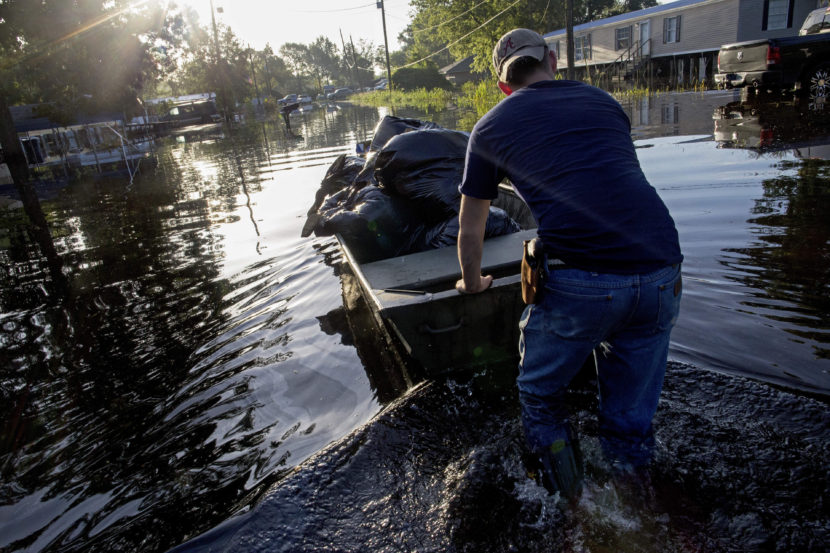
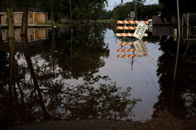
Schools near the Florida coast have been closed so they can be used as staging areas for emergency responders, member station WFSU reports, and many coastal residents have been urged to evacuate their homes. A storm surge as high as 9 feet is expected, NHC forecasters say.

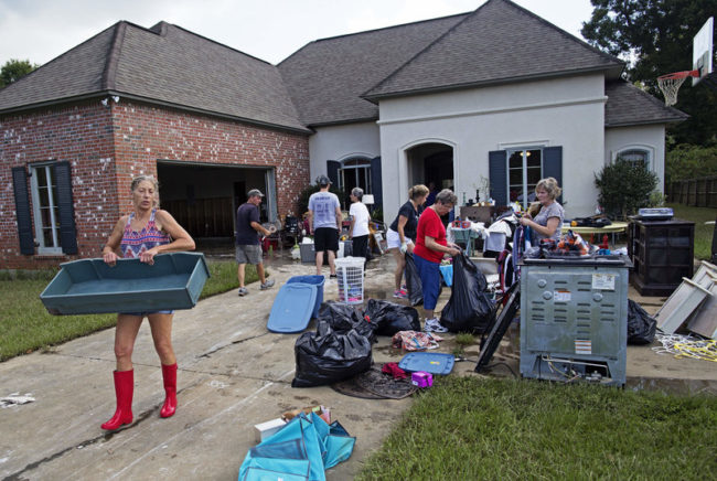
The AP quoted Tallahassee Mayor Andrew Gillum as saying the storm downed trees and knocked out power to some 100,000 residents. Outages also were reported in Georgia and the Carolinas.

As the storm moves east, the Weather Underground’s WunderBlog says rainfall could total 6 to 10 inches across broad swaths of the Southeast, with isolated areas getting as much as 15 inches.

When it swirled ashore in Florida, the storm ended a “drought”: The state had gone nearly 11 years without a hurricane making landfall. Wilma hit Florida in 2005 as a Category 3 storm.

And just by reaching hurricane strength, Hermine broke a three-year streak without any hurricanes in the Gulf.

In a statement Thursday evening, Florida’s governor urged residents to be alert, follow safety plans and evacuate if asked.

“It is still up to every Floridian to do their part to make sure they and their families are ready,” the statement read. “For the first time in over a decade, Florida is facing a hurricane. Hurricane Hermine is going to be here in the next few hours and everyone must take this seriously. Please remember that while we can rebuild your home or your business, we cannot rebuild the loss of life.”

The governors of Florida, Georgia, North Carolina and Virginia all declared states of emergency ahead of Hermine.

In Georgia, the AP reported, some authorities were urging those who live in mobile homes to get to shelters ahead of the storm.

Copyright 2016 NPR. To see more, visit http://www.npr.org/.

Tropical Storm Hermine strengthens as it approaches Florida

A satellite image shows Tropical Storm Hermine forming in the Gulf of Mexico on Wednesday. The storm is expected to make landfall north of Tampa late Thursday night or early Friday morning, the National Hurricane Center says. (NASA/NOAA GOES Project)

Tropical Storm Hermine, in the Gulf of Mexico, is growing stronger as it approaches the Florida coast, the National Hurricane Center says.

The storm, which has been moving very slowly, is forecast to strengthen into a hurricane before making landfall north of Tampa likely early Friday. It’s then predicted to pass overland toward the coasts of Georgia, South Carolina and North Carolina, weakening as it goes.

If the storm does become a hurricane before landfall, it would end a remarkable streak — it’s been nearly 11 years since a hurricane made landfall in Florida. Hurricane Wilma hit Florida in 2005; since then, not a single hurricane has made landfall along the Florida coastline.

It would also be the first hurricane to form in the Gulf Coast since 2013, ending the longest streak of hurricane-free days recorded in the last 130 years.

As a caveat to both those “droughts,” however, we should note that storms that are not hurricanes can cause devastating damage. And a recent article in the Bulletin of the American Meteorological Society, addressing the frequency of major hurricanes making landfall in the U.S., called the definition of such a drought “largely arbitrary.”

Whether Hermine strengthens to a hurricane or not, the National Hurricane Center warns of strong winds and a dangerous storm surge along Florida’s Gulf Coast and says rain accumulation may cause flash flooding in any of the affected states.

There’s also a risk of tornadoes, the center says.

Florida Gov. Rick Scott ordered all state offices in 51 counties to close at noon on Thursday, and Georgia Gov. Nathan Deal declared a state of emergency in 56 counties ahead of the storm.

Meanwhile, Hawaii has dodged a direct hit from one of two powerful storms in the Pacific, as Bill Dorman of Hawaii Public Radio reports for our Newscast unit:

“Tropical Storm Madeline did not make a direct hit on the Big Island of Hawaii. The center of the storm passed south of the island, but high winds and heavy rains did barrel ashore, sparking a flood advisory.

“Madeline was downgraded from a hurricane on Wednesday but remained strong enough to cause damage. About 3,600 customers lost electricity during the day; the Hawaii Electric Light Co. reported most had power restored by nightfall.

“Hurricane Lester remains farther off the coast of the island chain and has weakened — but still remains a potential threat for Labor Day weekend.”

Copyright 2016 NPR. To see more, visit http://www.npr.org/.

As summer ends, daily high temperature records fall around the state

A dog swims in University Lake in Anchorage on Aug. 31, 2016. (Photo By Annie Feidt/Alaska's Energy Desk)
A dog swims in University Lake in Anchorage on Aug. 31, 2016. (Photo By Annie Feidt/Alaska’s Energy Desk)

In climate terms, Wednesday marks the official end of summer. That’s because June, July and August are the hottest months of the year. And in Alaska, it was really hot this summer.

Nine communities around the state broke daily high temperature records Tuesday, including Kenai at 71 degrees, Bethel at 72 degrees and Anchorage at 74 degrees.

Brian Brettschneider is a climatologist in Anchorage who closely tracks Alaska climate data and trends. Alaska’s Energy Desk is checking in with him regularly as part of the segment, Ask A Climatologist.

Brettschneider told Energy Desk editor Annie Feidt that this summer is the warmest on record for the city of Anchorage.

Interview transcript

Brian: For most stations in Alaska it’s been a top five warmest (summer). In a few places, like Fairbanks, it’s the tenth warmest. But very warm from north to south, from east to west.

Annie: Has Anchorage been the warmest, in terms of records?

Brian: Well, not so much in terms of absolute temperature, because we are on the coast and it’s always going to be warmer than the interior. But as far as why we’ve been warmer than anyone else, it’s really because of our proximity to the Gulf of Alaska and the much above normal water temperatures. And also, our low temperatures have been very, very warm compared to normal. We’ve had extended periods of time with low temperatures well above normal.

Annie: And talk about the last week, or the last few days. What daily records have we seen here, especially in Anchorage?

Brian: So here in Anchorage for Saturday, Sunday and Monday, we had high temperatures that were all records. It was 73, 77 and then 72. And that’s the latest we’ve gone into a season with three consecutive days at that temperature, so it really is quite unusual.

Annie: And what about the rest of the state?

Brian: There were a number of places in the state that actually set their warmest temperature for so late in the season. So up on the north slope at Barrow, and Nuiqsut and a couple of other places, they were well into the 60’s, mid to upper 60’s — again, never so warm this late in the season — they had a south wind, an offshore wind. And then along the Gulf of Alaska coast, places like Anchorage and Cordova and Yakutat and a few others, they also set their highest temperature ever measured for so late in the season.

Do you have a climate question for Brian? Email akenergydesk@alaskapublic.org


Salvation Army seeking donations for Coats for Kids

The Salvation Army is collecting coats for school-age children again this year, and they are relying on more individual donors.

The organization is hoping to collect enough money and new or slightly used coats this year to help 3,000 kids from kindergarten to 12th grade.

Salvation Army Capt. Diana Gomes said they distributed 2,000 coats in the city last year, and it wasn’t enough.

“It’s very hard because it’s first come, first served, and the families are in line by the time we open. Like said, by noon (on distribution day), we were done with most of the large coats.”

She says they are hoping for more community contributions because one of the organization’s major donors is supporting other programs this year instead of Coats for Kids.

Salvation Army Communications manager Thomas Brown said they are also anticipating a greater need because of the economic downturn.

Salvation Army officers around the state are receiving more requests for help, especially for seniors, he said..

You can find ways to donate through the Salvation Army Alaska Facebook page. They’re collecting coats through September 24.

Low sea ice and warm water to drive autumn weather

Coast Guard Cutter Healy July 13, 2015
The Coast Guard Cutter Healy patrols the Arctic Ocean during a joint civil and federal search and rescue exercise near Oliktok Point, Alaska, July 13, 2015. The Healy is a 420-foot icebreaker homeported in Seattle. (Photo by Petty Officer 2nd Class Grant DeVuyst/Courtesy U.S. Coast Guard)

El Nino has transitioned to below normal sea surface temperatures in the mid-latitude Pacific.

If that persists, then the condition known as La Nina, typically results in a colder than normal winter for Alaska.

However, National Weather Service climate science and services manager Rick Thoman said low sea ice and remaining warm water around Alaska, will be primary drivers of the state’s autumn weather.

“The Gulf of Alaska, the Bering Sea on up into the Chukchi Sea … much warmer than normal,” Thoman said. “That heat will take a while to dissipate. Sea surface temperatures don’t typically reach their maximum until the end of August or even early September so that’s kinda locked in.”

Warmer seas provide more, potentially rain and snow yielding, moisture to the air, Thoman said.

“That’s one part of the equation,” Thoman said. “The other part of the equation is we had to have the atmospheric conditions. We need storms to be able to turn that moisture into precipitation. Typically in the autumn, that’s not so hard to do.”

Thoman stressed that ocean temperatures and moisture most directly impact coastal weather.

“Once we move inland a little bit, then it becomes more complicated. For instance, across the Interior, if our dominant flow during the fall is out of, say the East or the Northeast from Canada, well… it won’t matter very much that the oceans around us are warm, cause that’s not where our air’s coming from. So it can have a potential effect, but away from the coast, there’s other factors involved.”

Thoman cautions that while the overall fall outlook for Alaska is for warmer than normal, there can still be below normal days, weeks or even a month.

Louisiana Takes Stock Of The Damage After Devastating Flooding

Daniel Stover, 17, moves a boat of personal belongings from a friend's flooded home in Sorrento, La., on Saturday. Max Becherer/AP
Daniel Stover, 17, moves a boat of personal belongings from a friend’s flooded home in Sorrento, La., on Saturday.
Max Becherer/AP

Louisiana is entering recovery mode after devastating flooding killed 13 people and damaged at least 60,000 homes across 20 parishes.

But as Louisana Gov. John Bel Edwards told CNN, that process is “going to take many months.” He added that even though this flooding was “unprecedented and historic,” many are “just now realizing how significant it was.”

The Red Cross said the Louisiana flooding “is likely the worst natural disaster in the United States since 2012’s Superstorm Sandy,” and response efforts are “expected to cost at least $30 million.”

Edwards emphasizes that the state “really needs help.” Here’s more:

“Typically by this point in a storm, I think Red Cross would be receiving a lot more donations, I think there would be more volunteers signing up. Although we have some of that in place now, it would be very helpful if people would donate to the Red Cross, to the Baton Rouge Area Foundation, and also to come volunteer to help people get back in their homes as quickly as possible.”

Standing water closes roads in Sorrento, La., on Saturday. Max Becherer/AP
Standing water closes roads in Sorrento, La., on Saturday.
Max Becherer/AP

The governor’s office said “102,000 have registered for federal help,” as the Associated Press reports. FEMA spokesman Rafael Lemaitre said “more than 25,000 have filed flood claims.”

State officials estimate that 60,000 homes were damaged. But a report from the Baton Rouge Area Chamber, a local economic development group, put the number at 110,000. From member station WWNO, reporter Ryan Kailath explained the discrepancy to our Newscast unit:

“The higher local estimate is actually the total number of homes in the floodplain area, whether or not they’re damaged. The much smaller number that officials keep repeating is the number of homes that have been reported damaged.

“Because payouts can be tied to damages, each side has an interest in setting the number. After Hurricane Katrina, the numbers were still being debated long after the storm, with state estimates much higher than federal ones.”

Raven Harelson, 59, (left) carries a drawer to the trash heap in front the home of Sheila Siener, 58, as friends and family help to clean out the flood damaged home in St. Amant, La., on Saturday. Max Becherer/AP
Raven Harelson, 59, (left) carries a drawer to the trash heap in front the home of Sheila Siener, 58, as friends and family help to clean out the flood damaged home in St. Amant, La., on Saturday.
Max Becherer/AP

Regardless of the number of structures, The Advocate said residents are beginning to dig out their waterlogged homes, creating “massive debris piles” on the streets of Baton Rouge.

“Clothing and children’s toys, along with water-soaked carpeting and sofas and damaged refrigerators and stoves and the bric-a-brac of daily life were stacked outside houses” in the Baton Rouge area, as the newspaper reported.

Mike Johnson told The Advocate that his family home was flooded and “just about everything” was lost. “The hardest part of it is a lifetime of accumulation gone in a couple of hours,” he said. “Now it’s back to the drawing board.”

As Kailath reported on Weekend Edition Sunday, tens of thousands of South Louisiana residents were taken by surprise at the rising floodwaters, despite warnings.

He said “family after family” told him the same tale: “They heard the warnings, and thought — it won’t happen to me.”

That may be because many of areas hit are inland, and not ones that typically experience flooding. “People have a hard time grasping things they haven’t experienced,” Marshall Shepherd, the former president of the American Meteorological Society, told Kailath.

According to Shepherd, “people around the world are going to see more and more weather for which they have no reference point.”

Meanwhile, multiple counties in south and central Texas are threatened with flash flooding, with reports of water rescues.

Copyright 2016 NPR. To see more, visit http://www.npr.org/.
Site notifications
Update notification options
Subscribe to notifications