Sen. Lisa Murkowski in 2014 (Photo by Skip Gray/360 North)
Sen. Lisa Murkowski sent a letter today asking the federal government to extend the comment period for the proposed Pebble Mine in the Bristol Bay region.
The current 90-day public comment period ends on May 30. The senator wants the Army Corps of Engineers to give the public an additional 30 days to weigh in.
Murkowski wrote that the extension is needed “given the length and complexity” of the corps’ environmental impact statement for the mine proposal.
“I make this request for this proposed project as an exception to my general view about the appropriate length of comment periods for EISs under the National Environmental Policy Act,” Murkowski wrote.
She also asked the agency to “redouble” its efforts “to engage in meaningful consultation” with Alaska Natives in the Bristol Bay region.
Many of Pebble’s opponents also have asked for a longer comment period.
In March, the Associated Press reported that the corps project manager handling the permit application said it had not received a strong reason to extend the comment period.
On Wednesday afternoon, corps spokesperson John Budnik said the agency is aware of the senator’s letter but had not yet received an official copy.
“We have taken unprecedented steps to ensure that the public has access to all the information that we have received from the applicant and that information is available for public review as close to real time as we can manage,” Budnik said.
He added, “we carefully scheduled the public comment period to reflect input we received from rural communities and tribes regarding their availability to participate in the public process.”
But Budnik said the agency hasn’t yet made a final decision on whether to extend the comment period, noting it has until May 30 to do so.
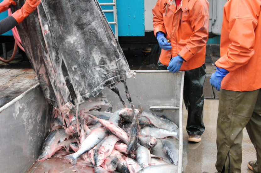
Sockeye salmon delivered in Bristol Bay. (File photo by KDLG)
Six Bristol Bay commercial fishermen are suing a regional seafood association they belong to, challenging over $250,000 in contracts it made with groups that advocate against the proposed Pebble Mine.
The Pebble Limited Partnership confirmed it is paying for the litigation.
The plaintiffs — Trefim Andrew, Tim Anelon, Gary Nielsen, Henry Olympic, Abe Williams and Braden Williams — are challenging the Bristol Bay Regional Seafood Development Association’s recent contracts with SalmonState and the United Tribes of Bristol Bay. Both SalmonState and UTBB are ardent Pebble opponents.
In their complaint, the plaintiffs allege the lawsuit is justified because BBRSDA can only use its funding to market seafood, based on the state statute that allowed for its creation.
BBRDSA leaders said they believe the lawsuit is designed to limit their participation in the ongoing federal public comment period for the proposed Pebble Mine.
“Consumers choose to pay more for wild sockeye salmon because it’s a healthy, abundant, premium wild salmon species from a pristine and unspoiled environment,” BBRSDA executive director Andy Wink said in a statement. “The Pebble Mine could jeopardize that, and at the very least we believe it’s important to engage in the permitting process so that if the mine does proceed, it’s built with adequate safeguards for fisherman, residents, and sockeye consumers.”
BBRDSA characterized its contracts with SalmonState and UTBB as funding for “educational efforts.”
Pebble Limited Partnership spokesperson Mike Heatwole said in an email it is backing the plaintiffs “as they have limited personal funds.”
“There were several fishermen that we’ve gotten to know over the years who were quite angered by the fact that the taxes they pay on their fish landings is not being use to market and promote the fish,” Heatwole said.
Abe Williams, one of the plaintiffs, commercial fishes in Bristol Bay and is also employed by the Pebble Limited Partnership as a regional outreach director. He used to be on the BBRDSA’s board.
“Over many years I’ve addressed these guys in regards to how they are utilizing our funds. There are many of us that said, ‘listen, this organization is doing something it wasn’t designed for,’” Williams said.
Most commercial fishermen in Bristol Bay are required to join BBRSDA. They pay a 1% tax on the fish they catch and sell, which funds the association.
Williams supports the Pebble Mine proposal, saying it would provide needed jobs in the Bristol Bay region. He said he’s proud to work there. But Williams said in participating in the lawsuit, he’s mainly acting in his interest as a fourth-generation commercial fisherman.
“My concerns about the BBRSDA spending the money the way they were was long before I was working at Pebble,” Williams said.
Williams and other plaintiffs are asking a judge to immediately prohibit BBRSDA from using its resources to impact the Pebble Mine permitting process.
Scott Kendall, the attorney representing BBRSDA, argued the contracts fall well within the realm of what the organization is supposed to do.
“It’s the number one issue that could impact the value and marketability and the sustainability of the fishery,” Kendall said. “How, if you are an organization whose sole purpose is to maintain the marketability and sustainability of the resource, do you ignore the Pebble Mine? It would seem to me to be almost absurd.”
Kendall noted the lawsuit was filed during the Army Corps of Engineers’ public comment period for Pebble’s latest mine proposal, which ends May 30.
“If successful, they would muzzle BBRSDA — BBRSDA would be denied the ability to create science and to create comments that would go into the comment period. It’s kind of a one-time shot, and on May 30, that expires,” Kendall said.
Pebble spokesperson Heatwole denied that charge, saying in his statement the lawsuit is not meant to challenge BBRSDA’s ability to comment on the mine.
“Their efforts can continue but it shouldn’t be done with fish marketing money,” Heatwole said.
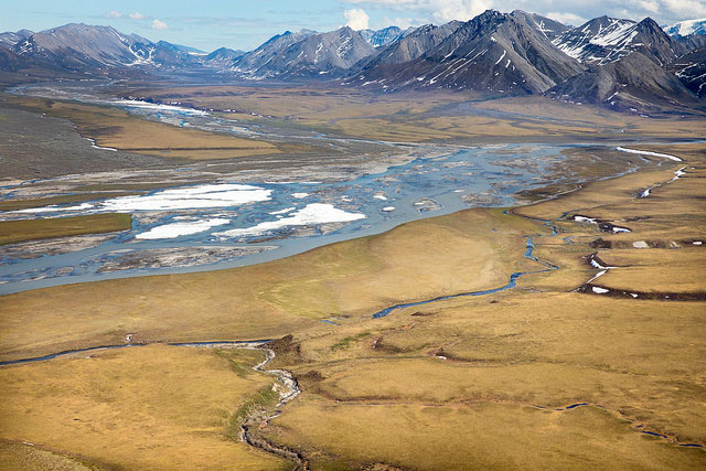
The Canning River, which forms the northwestern border of Arctic National Wildlife Refuge. (Photo: Lisa Hupp/USFWS)
This week, the New York Times published a story uncovering a long-held Alaska secret, revealing that the only exploratory oil well ever drilled in the Arctic National Wildlife Refuge was “worthless.”
Alaska’s Energy Desk reporter Elizabeth Harball talked to Henry Fountain, one of the New York Times reporters who broke the story. This interview has been edited for length and clarity.
Elizabeth Harball: For those who don’t know about this test well drilled in the Arctic Refuge in 1986, Henry, remind us what it is and why it was such a big secret for so long.
Henry Fountain: Well, it’s the only well that’s ever been drilled within the area of the Arctic National Wildlife Refuge. Because it was all proprietary — it was a private deal — the oil companies have kept the information confidential for years. They actually sued the state of Alaska at one point to keep the data confidential. And because it’s the only actual hole in the ground that’s been drilled in ANWR, it’s considered to be valuable information. The times I’ve been to Alaska, it seems like everybody has something to say about “you know, that KIC well — they drilled it years ago. Nobody knows what it said.” So it’s a subject of much interest.
Harball: Many Alaska reporters, including myself, have been fascinated by this secret for a while. It’s just such a good mystery. Do you want to say anything more about what intrigued you about the story and why you decided to try to uncover the results?
Fountain: Steve Eder and I did a story a couple of months ago that looked at what’s been going on with ANWR under the Trump administration. As you’re well aware, the administration has moved to open the area to oil and gas exploration after decades when it’s been pretty much off limits. In doing that story, we kept hearing reports about the KIC well and how that had provided some clues, but nobody knew what the clues were. So it piqued our interest. And then after that story appeared, we started hearing whispers about there might be ways to figure out what was in that well. We were directed to this court case that we ended up writing about, in which the well was a subject.
Harball: You and your co-reporter, Steve Eder, found the answer in Cleveland, Ohio, of all places. Talk me through what led you there.
Fountain: Well, again, it was this 1987 court case. At the time BP owned, I think, 45% of Standard Oil of Ohio. And they were looking to buy the rest of it. So the shareholders of Sohio thought that the offer that BP was making for their shares was low. They wondered if they were getting — their lawyers in particular wondered — if they were getting cheated. And one of the lawyers had realized, “hey, BP had been involved in this drilling project up in ANWR, this KIC well.” And he wondered if maybe they discovered some incredible reserves of oil and were trying to essentially cheat Sohio’s shareholders. So he pursued it through the court with BP, and eventually BP agreed to let him depose a man who was one of their chief petroleum engineers. And that’s where it was revealed, according to all accounts, that the well was not very encouraging, and didn’t have a big finding of huge reserves, and therefore BP was not, in fact, cheating Sohio.
Harball: And that lawyer’s name is Sidney B. Silverman, is that right?
Fountain: That is Sid Silverman.
Harball: And why do you think he decided to talk now?
Fountain: Well he told us, and we put it in our story. He felt because of what the Trump administration wants to do in the 1002 area, that this thing about the KIC well should be part of the discussion, at least. And he knew the secret — he’d been quiet for 32 years. But he felt it was — I wouldn’t say he said it was his patriotic duty, but he did feel very strongly that all the information about this area, or at least whatever information there is, should be on the table. I think that was his motivation.
Harball: In your story, Mr. Silverman calls the well ‘worthless,’ which is fascinating, but also it’s my understanding that a single dud test well doesn’t mean there’s no oil to be found the Refuge — which you say in your story, too. And so if that’s the case, what should we take away from this revelation?
Fountain: It’s true — it’s just one data point and it does not necessarily mean there’s not oil somewhere in the Refuge — significant oil, an economically recoverable amount of oil. The U.S. Geological Survey has done a couple of studies over the years and has estimated that anywhere from a billion or so barrels up to, I think, the highest estimate is 15 or 16 billion barrels, which is Prudhoe Bay size. Nobody really knows. Part of this whole Trump administration process involves a plan to do new seismic studies. And if that were to go ahead — environmentalists and others think that’s not a good idea — but if that were to go ahead, that would provide a significant amount of information that might totally confirm that the KIC well was representative of the entire area, or that the KIC well was not representative of the entire area and, in fact, there are significant reserves there.
Harball: Given everything you said, I’ve been privy to a ton of speculation on whether there will be much industry interest in the ANWR lease sale, when it happens. So what do you think this story sheds light on, amidst the mass of speculation that’s happening right now?
Fountain: It’s a good question. One of the things in all of our reporting from Alaska has been, why aren’t the oil companies more interested? At least from a public standpoint, most of them are not making big statements like, “we can’t wait for the opportunity to explore up there.” So you kind of wonder why they’ve been quiet — whether they know something or they knew something that we didn’t know. I think there will still be speculation, simply because one well is not representative, necessarily, of the whole area. So how much effect this will have, I don’t know. I think there are a lot of other factors involved. Even if there’s plenty of oil, it would certainly not be the cheapest oil to drill for and get. There’s plenty of cheap oil in the Lower 48 these days, particularly with fracking. There might be some concern about reputation, if an oil company aggressively wants to go into the Arctic National Wildlife Refuge, which a lot of people view as a very beautiful landscape, one of the last huge, remaining pristine landscapes in the United States. So there are a lot of factors of why there’s still a lot of speculation.
If you ask anyone at BP about its 3D seismic program at Prudhoe Bay this winter, they’ll tell you it’s a big deal for the oil company.
Take Richard Beavers, a seismic health, safety and environment expert at BP who is helping oversee the program. He said he’s considering getting a tattoo on his arm to remember it by.
“I’m going to get a polar bear,” Beavers said, with “seismic imaging in the polar bear.”
If you’ve heard the term “3D seismic” lately, it was probably in the context of the controversy over oil exploration in the Arctic National Wildlife Refuge. There were plans to do 3D seismic in the Refuge this winter, but those plans didn’t pan out.
But you might still be wondering: What is 3D seismic? And why do oil companies do it?
This winter, a visit to already developed state land next door to the Arctic Refuge provided a good primer on what 3D seismic technology is all about.
The basic purpose of 3D seismic is to look for oil, so it might seem odd that BP is doing it in a place where oil was discovered long ago. But today, Prudhoe Bay is sending a lot less oil down the pipeline than it did when it started up over four decades ago. BP, which operates Prudhoe Bay, has worked hard to flatten production there after years of decline.
The 3D seismic survey is part of the effort to keep the oil field alive for decades to come.
“We’re looking for small pockets of oil that haven’t been produced yet,” said BP’s Robert Pool.
Pool is a seismic acquisition specialist for BP. And on a not-too-chilly March day, Pool acted as a North Slope tour guide, showing a group of reporters how 3D seismic works.
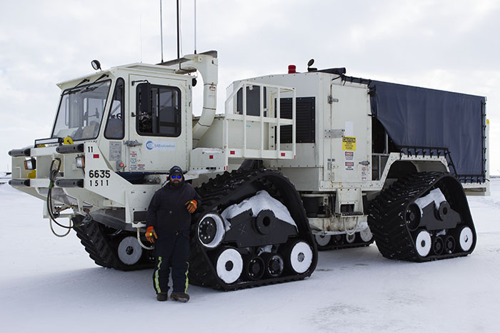
A worker stands in front of a vibe truck being used as part of BP’s 3D seismic program at Prudhoe Bay this winter. (Photo by Elizabeth Harball/Alaska’s Energy Desk)
We exited a bus and stepped on to a snow-covered gravel pad near the heart of Prudhoe Bay. On the flat horizon, there were pipelines, drill rigs and a big olive-green pump station facility. Here, we got an up-close view of one of the key pieces of equipment used with 3D seismic: a vibe truck.
It’s about the size of a cement truck, weighing in at 93,000 pounds. Instead of tires, it’s on wide tracks designed to help protect the tundra. It rolled along at 3 miles per hour. And every 110 feet it stopped, and that’s when the action happened.
A big, flat metal platform slowly descended from the belly of the truck and made contact with the ground. Pistons above the platform began moving faster and faster. Eventually, standing right next to the truck, we could feel the ground vibrating below our feet — a tingling sensation coming from beneath our boots.
“We’re sitting on six feet of gravel,” said Pool. “When we’re out on the actual tundra, you can feel it a little more.”
The vibe trucks perform just one step in a much bigger process. In fact, there are well over 100 workers in vehicles and stations all around the trucks. Some travel in front of the vibe trucks, checking for hazards. Others set up a grid of receiver devices around where the trucks are working. Others, in mobile blue buildings on tracks, direct the trucks and begin the process of downloading the data.
The vibe trucks create sonic energy that travels thousands of feet below the ground, echoes off the rocks below and gets picked up by the receivers that record the data.
“As the energy wave goes through the subsurface, the rocks are in layers, and the layers are based in hardness,” Pool explained, standing over a receiver marked by an orange traffic cone. “A harder layer, the sound wave goes through faster. And a softer layer, it goes through slower.”
The receivers pick up those differences in the sound waves bouncing back. The array of receivers work together to measure the wave front as it blossoms to the surface. BP processes that data with computer programs to create a “cube” of seismic information — that’s the 3D part.
“Our cube is going to be 400 square miles big, of data,” Pool said.
Using the data they collect, BP can piece together a detailed picture of the geology below, helping the company find hidden pockets of oil they haven’t drilled yet. The contractor doing the work for BP is SAExploration, the same company that had been planning on doing a survey in part of the Arctic National Wildlife Refuge this winter.
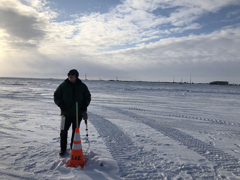
BP’s Richard Pool stands next to a receiver, which picks up sonic waves sent by the vibe trucks. (Photo by Elizabeth Harball/Alaska’s Energy Desk)
According to Pool, this winter’s survey at Prudhoe Bay is the biggest of its kind ever done in the Arctic. It will ultimately sweep over 450 square miles.
“It’s an impressive project,” Pool said.
From January until April, the vibe trucks are traveling back and forth — and back and forth and back and forth — making passes from west to east, all across Prudhoe Bay.
By March 27 — the day of the reporter tour — Pool said the crew had driven a total of 39,800 miles.
“That’s more than once around the world,” Pool said.
The team is working in shifts, pretty much nonstop, 24 hours a day, seven days a week. They even bring fuel out to the vehicles as they work.
That’s so they can squeeze the whole project in to a single winter season. The state only allows the company to do this work when the tundra is frozen and covered with a certain amount of snow, to minimize damage.
“A winter seismic survey does mitigate a lot of your general environmental concerns and impacts,” said Chrissy Pohl, BP’s permitting and regulations adviser for wildlife and environmental studies. “By having these heavy trucks on snow and ice rather than directly on the tundra, you’re hopefully walking away with no visible sign that a survey ever occurred.”
BP works to cut down on other environmental impacts during the 3D seismic program, such as impacts to wildlife.
Because Prudhoe Bay area is polar bear habitat, BP needed federal authorization to conduct 3D seismic there. Before the program started, the oil company did two aerial surveys using infrared technology, searching for potential polar bear dens. Had the company found a polar bear den — which they did not — there would have been a one-mile buffer zone around the den where no 3D seismic would have been allowed.
BP did find three grizzly bear dens in the project area, and those dens have buffer zones, too.
Environmental groups have voiced strong opposition to the prospect of 3D seismic work in the Arctic National Wildlife Refuge, especially when it comes to potential impacts to polar bears. Such opposition has not materialized for BP’s work at Prudhoe Bay.
“Seismic operations in areas that are already industrialized, such as near Prudhoe Bay, are not of great concern,” explained Lois Epstein, Arctic program director with the Wilderness Society in Anchorage. “To us, it makes sense to produce additional oil from areas that already have been adversely impacted by oil development.”
Epstein said her group is against to seismic operations “on sensitive, wild public lands” like the Arctic Refuge’s coastal plain or ecologically rich areas in the National Petroleum Reserve-Alaska.
As for Richard Beavers’ polar bear tattoo, he’s not completely sure he’s going ahead with it. But that’s not the only way he’s commemorating the 3D seismic effort. He’s also growing a beard for the duration of the project, even though he said he’s not really a beard guy.
“I’m done with it. Soon as the survey’s over: April 16, the beard gets shaven off for sure,” Beavers said.
The view of the Chukchi Sea from the Utqiaġvik coastline, October 26th, 2018. (Photo by Ravenna Koenig/Alaska’s Energy Desk)
The long-running saga of offshore oil development in Alaska has taken a new twist: A court ruling handed down late Friday blocked the Trump administration’s plans for oil lease sales in large portions of Arctic waters.
U.S. District Court Judge Sharon Gleason, in an opinion released late Friday, said President Donald Trump exceeded his authority by issuing an executive order in 2017 that reopened large parts of the Beaufort and Chukchi seas to offshore oil leasing.
Former President Barack Obama had banned development in those areas in his second term, saying they were too environmentally sensitive to drill.
But Friday’s decision once again blocks oil development in some 128 million acres of the Arctic and Atlantic oceans, an area twice the size of Colorado. It elicited cheers from conservation groups and condemnation from Alaska’s oil and gas industry boosters, who had hoped for lease sales as soon as this year.
“As of today, the law of the land is that the vast majority of the Arctic Ocean is permanently off-limits to oil and gas leasing. So that’s a really big deal,” said Erik Grafe, an Earthjustice attorney who helped argue the case. “It’s a great victory, and it was one of the great conservation actions of the Obama administration to take the vast majority of the Arctic off the table.”
Alaska Oil and Gas Association President Kara Moriarty said her group is disappointed by the ruling. The trend of on-again, off-again lease sales in Arctic waters isn’t attracting oil and gas investment to the state.
“The message that this sends is that maybe America isn’t open to having this awesome federal opportunity available for lease,” Moriarty said.
She added that she’s hopeful the decision can be appealed and overturned, saying there’s “huge potential” in offshore Arctic waters.
The lawsuit hinged on a single line in the Outer Continental Shelf Lands Act, which governs offshore leasing: “The President of the United States may, from time to time, withdraw from disposition any of the unleased lands of the outer Continental Shelf.”
Environmental groups argued that that language gave presidents the power to withdraw offshore areas from oil development, but not the other way around. The Trump administration argued that the language gives the president implied authority to put offshore areas back on the table.
Gleason, an Obama appointee, ruled in favor of the environmental groups’ interpretation.
“Had Congress intended to grant the President revocation authority, it could have done so explicitly,” Gleason wrote in her decision.
With Democrats now in control of the U.S. House of Representatives, it’s unlikely Congress will act to give Trump that power any time soon. Rep. Raúl Grijalva, D-Ariz., chairman of the House Committee on Natural Resources, praised Gleason’s order in a statement, calling it a “reckoning” for Trump.
But in an interview Monday, Republican Sen. Lisa Murkowski called the ruling “wrong as a matter of law and wrong as a matter of policy.”
“I do understand that there is some ambiguity within the law — I think she has seized on that,” Murkowski said, referring to Gleason. “But I would imagine that this is going to be appealed, and my hope is that they will make the right determination.”
The Trump administration has not said whether it will try to get a higher court to overturn the decision. An Interior Department spokeswoman, Molly Block, declined to comment Monday.
Gleason’s decision was the second one she released Friday in favor of environmental groups. In a different lawsuit, she rejected a Trump administration effort to facilitate construction of a road through a national wildlife refuge on the Alaska Peninsula.
This story has been updated. Reporters Liz Ruskin and Nat Herz contributed.
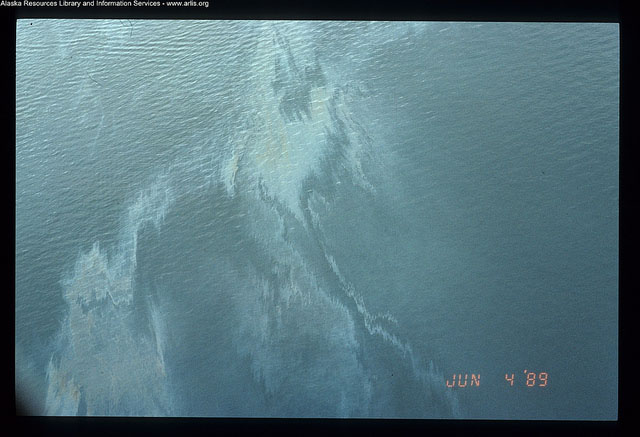
Slick on the water following the Exxon Valdez oil spill on March 24, 1989. (Public domain photo courtesy Alaska Resources Library & Information Services)
A coalition of environmental and public health advocates say they will sue the federal government unless it takes action to restrict the use of dispersants for oil spill cleanup.
The plaintiffs say the federal Environmental Protection Agency is shirking its duty to update its rules so that they reflect the latest science on how dispersants affect the environment. They argue the update is especially urgent now that the Trump administration is moving to expand offshore oil leasing, including in Arctic waters.
The news comes a day after the 30th anniversary of the Exxon Valdez oil spill in Prince William Sound, when thousands of gallons of dispersant were used.
EPA did propose stricter standards for dispersants in 2015. But the agency has not moved to finalize those standards since then. The plaintiffs say they will file suit in 60 days unless the agency renews its work on the issue.
“We’re very concerned about the lack of oversight and regulation that takes into consideration this newer science, and EPA is definitely long overdue in fulfilling their responsibility to regulate these chemicals,” said Pam Miller, executive director of the Alaska Community Action on Toxics.
Alaska Community Action on Toxics is one of the plaintiffs in the case, along with the Homer-based advocacy group Cook Inletkeeper, Nuiqsut resident Rosemary Ahtuangaruak, Louisiana resident Kindra Arnesen and California-based environmental advocacy group Earth Island Institute.
In a statement, EPA said the agency is reviewing the notice of intent to sue, but declined to comment further.
Dispersants don’t get rid of oil. They’re used to help oil dissolve in the water column so it doesn’t stay on the water’s surface or wash on shore.
The American Petroleum Institute, a national oil industry trade group, supports their use. API criticized EPA’s 2015 proposal, saying in a comment letter to the agency that it was “substantially problematic for all stakeholders, including the response community, which is required to carry out an effective spill response.”
Miller has the opposite view.
“I think it could have been much stronger,” Miller said.
Dispersants are highly controversial. Research following their use during the 2010 Deepwater Horizon disaster has deepened concerns about how they affect species and workers.
The Prince William Sound Regional Citizens Advisory Council, a watchdog group, opposes the use of dispersants in Alaska until there is enough evidence to prove they are safe and effective.
Oil spill response teams in Alaska are allowed to use dispersants, but there are standards restricting where and when they can be used. Those standards were updated in 2016, with input from EPA.
Close
Update notification options
Subscribe to notifications
Subscribe
Get notifications about news related to the topics you care about. You can unsubscribe anytime.