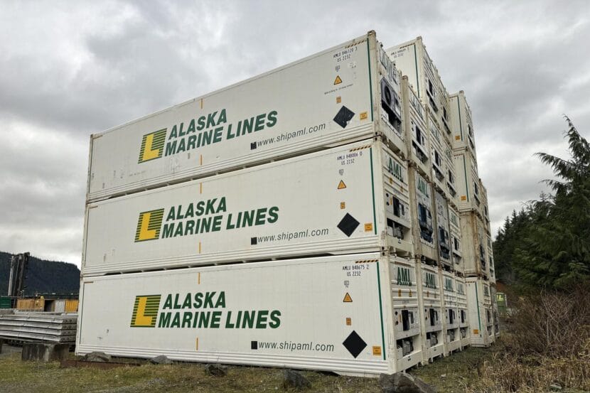
Alaska Marine Lines freight sits at a facility in Thorne Bay. (Hunter Morrison/KRBD)
An Alaska Marine Lines barge that was taking on water off the coast of British Columbia has continued its journey south to Seattle.
The barge was spotted floating lower than normal last week near Bella Bella, about 260 miles south of Ketchikan, on its way from Alaska.
According to an email from Alaska Marine Lines Director of Marketing Ryan Dixon, the barge was damaged during transit but was “secure” and “not sinking.”
Dixon said the barge was not carrying groceries or supplies for Southeast Alaska that could cause supply chain disruptions for the region. The barge also did not contain bulk cargo or petroleum products, according to the email.
On Tuesday, the company announced that a second barge was sent to offload some of its cargo. As of Sunday, both were en route to Seattle.
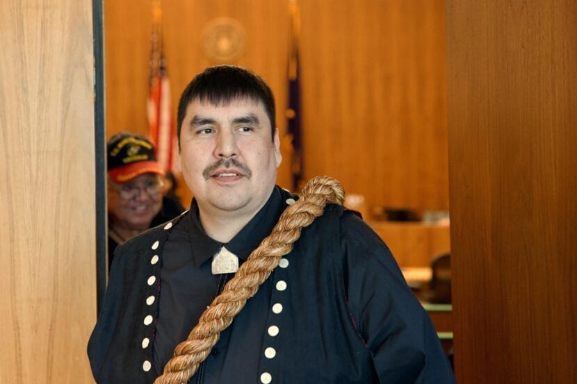
Metlakatla Mayor Albert Smith exits the courtroom at the Robert Boochever U.S. Courthouse in Juneau, Alaska following oral arguments in a fishing rights case on Feb. 15, 2024. (Eric Stone/Alaska Public Media)
A lawsuit from Alaska’s only Native reservation will proceed over the objections of other Southeast Alaska tribes. A federal judge last week declined a request from a coalition of tribes, including the largest in Southeast, to throw out Metlakatla Indian Community’s lawsuit challenging the state’s authority to regulate its fishermen.
Metlakatla Indian Community asserts in its five-year-old lawsuit that the state has no right to regulate the tribe’s fishermen. Its attorneys say that’s because when Congress created Metlakatla’s reservation in 1891, Congress implicitly included a federally guaranteed right to fish in nearby waters.
The case was headed for trial when a coalition of tribes, including the Central Council of Tlingit and Haida Indian Tribes of Alaska, weighed in, arguing it should be dismissed outright.
“They felt this was something that should be resolved between the tribes and not by a federal judge,” attorney Richard Monkman said in an interview.
The tribes argued granting Metlakatla’s members the right to fish in waters near Ketchikan and Prince of Wales Island would violate their rights to their cultural property.
“We would analogize this to other cultural rights, like dances, stories, carvings, other types of rights that all sort of fall under the general category of at.oow, in the Lingít language, or cultural rights, which belong to the clans and belong to the houses within clans,” Monkman said.
Metlakatla’s attorneys, however, argued that the right to fish in those areas wasn’t legally protected — in part because of the Alaska Native Claims Settlement Act. Chris Lundberg is an attorney representing Metlakatla.
“With the exception of Metlakatla, all Alaska Natives participated in that act,” Lundberg said. “In exchange for releasing all claims to aboriginal rights-type claims and claims to land and fishing areas, the tribes received compensation.”
There’s still a long way to go, and it’s unclear when it might go to trial — for one thing, the state has filed a motion to end the case without a trial — but Lundberg said the decision from Judge Sharon Gleason puts the case back on track.
Metlakatla Indian Community Mayor Albert Smith said in an interview he was pleased with the decision and is optimistic about the road ahead.
“Now we are excited about getting back to the main issue: restoring the community’s reserved fishing rights,” he said.
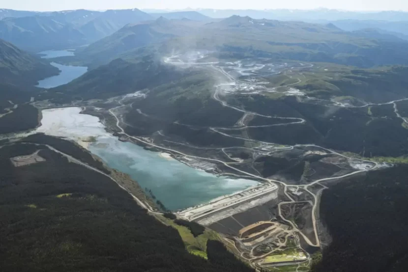
Red Chris Mine’s tailings waste facility and open pit in the headwaters of the Iskut River, a major tributary of the salmon-bearing Stikine River. (Photo courtesy of Colin Arisman)
Southeast Alaska tribes and environmental groups have delivered nearly 30,000 messages to British Columbia lawmakers about transboundary mining.
Earthjustice, the international conservation organization Re:wild and the tribal commission said the letters encourage British Columbia to pause mining developments in the headwaters of the Stikine, Unuk and Taku Rivers that drain into Southeast Alaska.
The Southeast Alaska Indigenous Transboundary Commission represents 14 tribal nations downstream from the mines. Executive Director Guy Archibald said it wasn’t just Alaskans who sent the letters.
“It was people from all over the country and all over the world that recognize that Southeast Alaska is a very unique and valuable place in the world for climate protections, for cultural protections and diversity,” he said.
The environmental groups urged British Columbia officials to freeze “mining activity in this region until SEITC member tribes are given free, prior and informed consent.”
They said the messages point to growing concern over mining in the region. This includes at least eight proposed and operating mines that threaten the transboundary watersheds.
Four mines in the Stikine River watershed
Archibald said there’s many active explorations going on with mines in British Columbia and eight is just the minimum. There are four mines the groups are concerned about in the Stikine River alone. They are Red Chris, Galore Creek, Schaft Creek and Red Mountain Mines.
“These mines pose a significant risk to the Stikine River, and so far, they’ve been permitted without any adequate consultation with the Southeast tribes,” he said.
Previous studies have shown that minimal regulation of mines leads to polluted watersheds. This affects where people who survive on subsistence food can hunt and fish.
British Columbia say they take their obligations ‘very seriously’
The British Columbia Environmental Assessment Office wrote in an email that they take their obligations “very seriously – including with tribes in the U.S.” They said they will continue to fulfill their constitutional obligations by consulting with U.S. tribes when mining practices impact aboriginal rights under the Canadian Constitution. Currently, the office said seven mines are permitted in the transboundary area.
This includes two fully operational mines — Premier Mine and Brucejack Mine — and five permitted for exploration or that have limited construction — Eskay Creek Mine, KSM Mine, Skip Mine, Scottie Gold and Galore Creek.
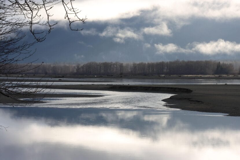
The Chilkat River, outside Haines, in November, 2025. (Avery Ellfeldt/KHNS)
A controversial mineral exploration project near Haines is again changing hands, just one year after the last shakeup.
Vizsla Copper Corp. said Thursday that it’s purchasing the Palmer Project from American Pacific Mining Corp. The project is a zinc, copper, gold, silver and barite exploration site that sits about 14 miles upstream from the Native village of Klukwan.
The new owner said it prides itself on its commitment to working with communities to earn local support – and that it will take the same approach in the Chilkat Valley.
“For us it’s a very straightforward job: Win community and First Nations and government support. And get in and drill some spectacular holes come summer next year,” Vizsla CEO Craig Parry said in a pre-recorded video posted on Thursday.
But as one local tribe sees it, that’s not in the cards.
“I seriously do not believe there is any opportunity to gain community support,” Chilkat Indian Village President Kimberley Strong said in an interview following the announcement.
The deal means Vizsla will acquire 100% of the project along with the project’s long-time local operator, Constantine Metal Resources. Vizsla noted in a statement that it will need to raise $25 million from investors to move forward with exploration.
American Pacific, for its part, will walk away with $15 million in Vizsla stock rather than cash.
The company could also net an additional $15 million, in either cash or shares, on two conditions. First, Vizsla would have to find that the project could yield a certain quantity of minerals. Second, the project would have to become a commercial mine.
American Pacific has been involved in the project since 2022 and became its sole owner at this time last year when DOWA Metals and Mining sold its majority stake. Then, this spring, American Pacific confirmed that it, too, planned to step back from Palmer.
The America Pacific Mining and Vizsla lauded the project as an exciting prospect, particularly amid the Trump administration’s embrace of mining in Alaska and the surging demand for critical minerals.
“The U.S. administration aside, you’ve seen a complete 180 degree turnaround from governments around the world,” Parry said.
He said that’s happening as countries recognize that the global transition away from fossil-based energy – and toward greener technology – will require these minerals.
Still, he emphasized that the project, which has been under exploration for nearly two decades, has a long road ahead.
“It’s crucial to highlight that this is a long way from being a mining project,” Parry said. “And there’s a lot of stages you have to go through to get there, so we’re many, many years away from that.”
The project has long fueled local debate over what a mine would mean for the Chilkat Valley. While some say it would boost the local economy, others contend it’s not worth risking impacts to the Chilkat watershed.
Parry, of Vizsla, acknowledged that the mining industry needs to do a better job of seeking and acting on community feedback. But he says his company has made that a priority, including on its Panuco Project, a silver and gold exploration site in Western Mexico.
“We’ve demonstrated that not only do we listen, but we act on what we hear from communities and First Nations groups and look to work in partnership with those guys,” he said.
The Chilkat Indian Village of Klukwan has opposed the project out of concern that it would contaminate the Chilkat River, which supports runs of all five species of pacific salmon.
Strong, the tribe’s president, said that concern will stand regardless of ownership. She is skeptical about any mining companies that claim to prioritize engagement with tribes, particularly given her experiences with the companies that have already had a hand in the local project.
“The moment we sit down with them, it’s considered engaging with the tribe,” she said. “They’ll come and listen, but they’ll still do whatever they want.”
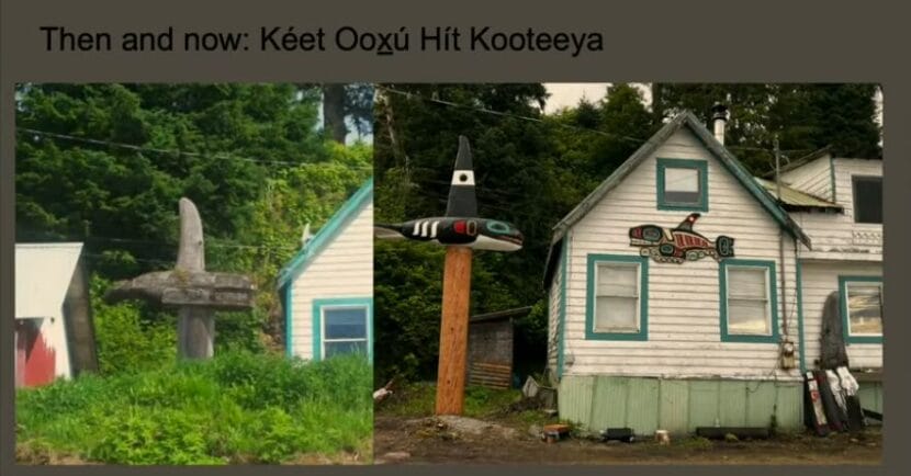
A screenshot from Shgendootaan George’s slideshow shows the kootéeyaa that was raised in the 1980s and the one raised this year. (Courtesy of presentation)
Addressing an audience in the clan house inside the Walter Soboleff building in Juneau, Shgendootaan George laid out the history of three killer whale totem poles that have stood next to her clan house in Angoon. The latest was raised in August.
For George, the history of the Killer Whale Tooth clan house and its kootéeyaa — or totem poles — are intertwined with her own personal history. She was nine years old when they raised a second pole commemorating the 100th anniversary of when the U.S. Navy attacked the village of Angoon.
“This picture is going to make me cry. This is my dad on top of the forklift helping place the killer whale as it goes on to the post,” George said, referencing a slideshow she presented during the lecture. “And this is me and my mom looking out the window.”
The 1882 bombardment destroyed the village, its clan houses, canoes and food supplies – just before winter set in. Six children died.
The memorial kootéeyaa depicted a black and white killer whale sitting on a tall stand. Master Carver Wayne Price carved it at Angoon High School. It replaced a similar pole that stood next to the house and was laid down before George was born.
“Then that’s where I spent the rest of my life after that,” she said. “Growing up with this totem pole next to our house.”
It aged too. She showed a photo of the same pole, with all of its paint worn away.
“And this is where, you know, it kind of ended up weathered and worn and moss growing on it,” George said.
When kootéeyaa begin to disintegrate, that is considered part of their life cycle, and they are taken down and laid to rest.
That also happened to the second pole in 2010. George led that process. The pole was laid to rest like a clan member: it was cremated.
Over the last decade, George also reconstructed the clan house that she grew up in and continues to live in each summer with her family.
And earlier this year, the newest killer whale kootéeyaa, carved by Joe Zuboff, was raised with the help of the people — and their descendants — who participated in the raising and lowering of its predecessor.
“One of the things that is really important to me in the raising of this most recent poll is to really be really thoughtful in thinking about continuity and really connecting with the past and bringing that forward into the future,” she said.
And now that the kootéeyaa is standing, and the house is restored, George has time to reflect on her experience.
“That was probably the biggest thing that I will ever be directly a part of in my life,” she said.
SHI President Rosita Worl attended the lecture, and applauded George and her community for the legacy they have carried forward.
“Look at the knowledge that you have, look at the practices that you can do,” Worl said. “It just warms my heart to see that Angoon has been the center and the stronghold of our culture.”
Last fall, the U.S. Navy issued a formal apology for the bombardment of Angoon, after clan leaders and Worl herself spent decades asking for one.
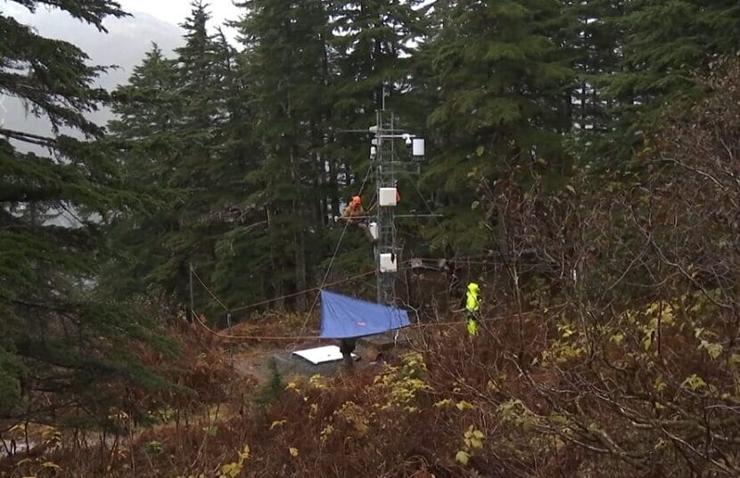
Mike Janes climbs up a weather tower on Mount Roberts to re-install snow sensors ahead of avalanche season. (Photo by Will Mader/KTOO)
Listen to this story:
Juneau’s avalanche forecasters are gearing up for winter. The state Department of Transportation and the local electric utility re-installed scientific instruments to help them predict avalanche risk at their largest research site in town.
Last month, avalanche forecaster Mike Janes rode the Goldbelt Tram, pulled on a harness and climbed a metal weather tower on the north-facing slope of Mount Roberts in the pouring rain.
“It gives us a baseline,” Janes said about the research site. “Here’s what the snowpack at this elevation in a sheltered area is doing.”
Janes works at Alaska Electric Light & Power. He sets up sensors that will help predict the threat of avalanches once Juneau’s famous rain turns to snow.
Mount Roberts and Mount Juneau loom over downtown. The steep slopes are marked by avalanches and landslides; their history is written in vertical chutes and tree rings. Avalanches are frequent in Juneau, but only a few have been disastrous.
In 1962, an avalanche hit dozens of homes in the Behrends Neighborhood downtown. In 2008, a massive avalanche took out AEL&P’s main power line to Juneau, forcing the city to rely on diesel generators for two months. Since then, the utility has built barriers to protect its energy infrastructure from future slides.
Janes said avalanches occur when a weak, unstable layer of snow forms, causing the layers of snow that accumulate on top to slide off. The instruments he installs on Mount Roberts will help him understand when that weak layer forms and where in the snowpack it is.
Watch a video about avalanche forecasting in Juneau:
First, Janes attached a snow height sensor to a pole about 15 feet up the tower. It sends down sound waves, which bounce off the snow and back to the sensor, measuring the snowpack’s height.
Then, he hung a string vertically from the tower that has nodes spaced 10 centimeters apart. That measures the various temperatures throughout layers of snow.
Next, Janes pointed to an instrument sticking off the side of the weather tower.
“That right up there — probably one of our most important instruments — that white cylinder with the black top,” he said. “That’s a heated tipping bucket, and that measures precipitation.”
It’s heated to melt snow, so forecasters can measure how much water is in the snowpack. Two more are lodged down the slope to measure water that’s melting beneath the snowpack.
Then he pointed to a small double-cylinder sensor called a net radiation meter.
“That particular sensor is important for understanding when we’re getting weak layers forming at the surface that are going to become problems later,” he said.
Earth gives off heat called long-wave radiation, which travels up through the snow and air and gets reflected back down to Earth by clouds that act as a thermal blanket. But on a clear night, that heat escapes into the atmosphere and can cause the top layer of snow to cool quickly, creating a sugar-like surface.
“If that stuff gets buried, then it becomes like a future weak layer that avalanches can run on,” Janes said.
This year, AEL&P, the Alaska Department of Transportation and other agencies will feed all of this data, and more, into a Swiss snowpack model.
Patrick Dryer is an avalanche and geohazard specialist at DOT. He said using the Swiss model could help Alaskans better predict how layers of snow are forming at high elevations.
“That’s especially relevant in Alaska, where we have limited high elevation monitoring sites, but we have miles of roadway that we’re forecasting for,” Dryer said.
He said using the emerging technology can help them make more informed decisions. Those decisions include things like setting off explosives to trigger avalanches before they become destructive, or putting barriers up to protect infrastructure in areas where avalanches happen frequently.
But Dryer said there’s a lot of variability between where they collect data and all of the places where avalanches can occur. Plus, snow dynamics change, so no prediction is perfect.