Tourism

Alaska ferry to host long-distance ocean acidification study

Researcher Wiley Evans installed equipment on the Alaska Marine Highway System ferry Columbia, to monitor ocean acidification along the ferry’s 2,000-mile route. (Photo by Leila Kheiry/KRBD)

The Alaska Marine Highway System ferry Columbia will be part of an international science experiment starting this fall when it resumes its weekly run between Bellingham, Wash., and Southeast Alaska.

Equipment has been installed to continuously measure the ocean’s acidity along the ferry’s nearly 2,000-mile route. The goal is to better understand how acidification affects regional fisheries.

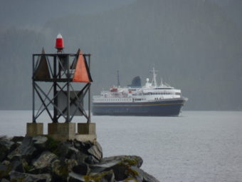
The 418-foot ferry Columbia is docked at Ketchikan’s Vigor Alaska shipyard while undergoing repairs to its propeller system.

That’s not great for ferry passengers, who have been sailing on the smaller Malaspina instead. But, it worked out for a team of scientists who installed a seawater-monitoring system on the Columbia before the ferry is due to resume service.

Wiley Evans is a researcher with the Canadian Hakai Institute, and is the technical lead in the program. Tucked under some stairs in a corner of the Columbia’s car deck, he shows me the newly installed equipment.

Evans said getting to this point took about three years.

“Allison Bidlack from Alaska Coastal Rainforest Center and I started talking about this in 2014,” he said. “In 2015, we did a similar installation on another passenger vessel. That was a glacier tour vessel that operated out of Whittier.”

That was a small catamaran.

“At the time, I felt it was fairly difficult, but now, having been through this installation – that was pretty easy,” he said. “The size of the (Columbia), The fact that it’s a ferry, and they’re very cautious about seawater flowing through the vessel and how it’s moving around the vessel.”

The seawater lines had to be engineered and installed.

Through those lines, seawater enters the system at the bow thruster cavity, and is pumped up to the equipment on the car deck.

“The water first flows through an oxygen sensor, then through a thermosalinograph, which measures the temperature and salinity of the water, and then into these boxes here, these larger boxes,” he said, pointing to some of the equipment. “The first is the wet box. Water goes into the wet box and is equilibrated with air.”

In other words, ocean water is sucked up while the ship is under way, and then is measured for oxygen, temperature and salinity – that’s how much salt it contains. Then it’s pumped into the wet box, where it is sprayed into a little container.

Air in that container picks up carbon dioxide contained in the water. That air then is pumped into dry box, which analyzes CO2 levels. Those levels indicate the acidity of the water.

Separate sensors measure carbon dioxide levels in the atmosphere, to compare that with the seawater.

“What we’re after is trying to understand the time and space patterns in surface ocean CO2 chemistry near shore,” he said. “In this area, it’s extremely data-poor.”

Evans said they hope to discover patterns of CO2 concentrations along the entire Southeast Alaska and British Columbia coastline. And the ferry is the perfect platform for gathering data.

“The fantastic thing about this vessel is it’s going from Bellingham to Skagway and back every week,” he said. “That’s a 1,600-kilometer run. Nowhere in the world is there a ferry system that’s outfitted with CO2 sensors that’s running that scale of a transit. This is really exciting.”

Evans said they expect to see seasonal changes in carbon dioxide, related to temperature; changes related to freshwater sources, such as glacier melt and stream outfalls; and changes connected to areas of large development.

“It’ll be a mosaic of different signals we’ll be seeing along the transit, and really fun to analyze from my standpoint,” he said.

Evans hopes the study can continue at least five years, but he’d really prefer it to last closer to a decade.

“The challenge is really first understanding what the natural variability looks like in this data-poor region, and then making measurements long enough that we can tease out the long-term ocean acidification trend, which is this gradual increase through time,” he said “It’s really hard to see with just one or two years of data.”

Evans said the data will help fisheries management, especially oyster farmers.

For example, a small, local study in Ketchikan has given area oyster farmers a better idea of when to put animals into the water.

“We’ve been able to define a seasonal window of opportune growth conditions,” he said. “That’ sort of starts around March or April, and ends about now.”

Crab also are affected by ocean acidification. Evans said it’s not clear yet how much it affects other fisheries.

“We’re still trying to work out what the links are and who exactly the winners and losers are going to be,” he said “It’s really clear that shellfish are on the losing side.”

The monitoring equipment will run continuously and automatically, so nobody needs to be there watching it. Evans said they do plan on one or two ride-alongs per year to make sure everything is working correctly.

The data will be available daily, though, through an antenna on the bow. It will upload automatically to a website, available through the Alaska Ocean Acidification Network’s site.

Evans said they’re designing it so that non-scientists can understand the data.

Alaska Marine Highway System environmental specialist Christy Harrington said ferry system officials were happy to work with the science team.

“It’ll be the biggest survey taking place in North America, from Bellingham to Skagway,” she said. “The route that the ferry takes is very close to shore compared to other units on board other vessels. It will give them a lot more data that they can use. We’re just very excited to be able to provide the resource for the oceanographic equipment to be on board.”

Evans said the study wouldn’t be possible without partners like the ferry system.

He also mentioned the Canada-based Tula Foundation, the Alaska Ocean Observing System, Alaska Coastal Rainforest Association, University of Alaska Southeast and NOAA.

“One of my colleagues from NOAA, who is sort of the brains behind this equipment, Geoff Lebon, we wouldn’t be able to do this without their support,” he said.

All those partners eagerly await the first data. The Columbia is currently scheduled to resume its regular run in late October.

You can learn more about the ferry study here.

Marine Exchange of Alaska now operating in new waterfront headquarters

Every different colored triangle represents a vessel equipped with Automatic Identification System or AIS that can be tracked by Marine Exchange of Alaska.
Every different colored triangle represents a vessel equipped with automatic identification system, or AIS, that can be tracked in the Northeast Pacific Ocean by Marine Exchange of Alaska. (Photo by Matt Miller/KTOO)

In a new building on the downtown Juneau waterfront, three people are watching rows of large monitors which line the wall of an operations center.

One of the monitors shows the latest marine and weather information from around Southeast Alaska. Another shows an Alaska map with dozens, perhaps even hundreds of colored triangles that represent — in real time — every large vessel traveling through Alaska waters and the Northeast Pacific.

The three-story building adjacent to Harris Harbor is the new location for employees of a statewide vessel tracking system, and it’s not far from their old building.

“Even though it’s only a hundred yards, it’s a big deal,” said Ed Page, executive director of Marine Exchange of Alaska. “I remember myself carrying these some of these servers and ‘I hope I don’t trip in the rain!’”

Page said they kept operating during the recent move, and any related outages probably lasted only for minutes.

“We literally had cables running along the waterfront on the beach, from one (building) to the other to ensure we had never lost any connectivity,” Page said. “Finally, we said ‘OK, we can throw that switch. Now, we’re operating on this side.’ But for a period of time, we had the servers in one building and the operations center in another building.”

It wasn’t ideal to have those servers down for any length of time, especially when they’re used to pull in information from other organizations around the world, like U.S. Coast Guard headquarters and Lloyd’s of London.

Those servers also are used to simultaneously monitor hundreds of vessels in Alaska waters in real time. But Page said they had no other option.

The new building for Marine Exchange of Alaska in downtown Juneau is adjacent to Harris Harbor.
The new building for Marine Exchange of Alaska in downtown Juneau is adjacent to Harris Harbor. (Photo by Matt Miller/KTOO)

Headquarters and operations center for the Marine Exchange used to be located in the nearby Juneau Electronics building next to the Douglas Bridge.

But Page said they began to outgrow it, and the building’s electrical and air conditioning systems couldn’t handle the load from all of those servers.

He said they began setting aside a portion of their revenue years ago to help pay for their own new $4 million building.

The private, non-profit organization tracks vessels using an automatic identification system, or AIS, box that each ship carries on board. It’s like an aircraft transponder for ships.

The Exchange tracks all of the vessels with nearly a hundred remote tracking stations they have built all along Alaska’s coastline.

The real-time data feeds into the operations center that was mentioned earlier by Page.

The organization has clients ranging from vessel owners to marine pilots, tug operators, cruise lines, tanker operators, and fish processing and shipping companies.

They pay a membership fee to see all the AIS information that comes into the Exchange.

Marine Exchange employees stand watch 24 hours a day, 365 days a year.

If any vessel appears to suffer from mechanical problems or deviates from established traffic routes, then an employee will contact the vessel’s crew to find out what’s happening.

Ed Page, executive director of Marine Exchange of Alaska, checks the latest marine and weather information from around the region.
Ed Page, executive director of Marine Exchange of Alaska, checks the latest marine and weather information from around the region. (Photo by Matt Miller/KTOO)

“The fact that you’re monitoring activity influence(s) behavior,” Page said.

Page is referring to extremely risky behavior like exceeding speed limits or straying outside of traffic lanes and getting too close to a dangerous shoreline.

Good information about a vessel’s location also is critical for efficient marine operations.

“Getting cargo off, getting supplies to the vessel, whatever, all dependent when a certain vessel arrives at a certain place,” Page said.

Page used an example of a typical cargo or container ship that that may be coming into port.

“Maybe 10 miles out, the pilot boards the vessel,” Page said. “A couple miles out, a tugboat meets the vessel. And then, closer to the dock, the shore gang, the line handlers show up. And then when it actually docks, the trucks and the cargo movers are there. There’s many different steps. All of that can be much more efficient if you have better information on where the vessel is all the time.”

Nineteen people work at the Marine Exchange of Alaska. Page said their annual budget is over $3.5 million dollars.

An open house of the new building is planned for next Friday and Saturday, Sept. 15 and 16.

No injuries in Sitka’s ‘pretty impressive’ Labor Day landslide

A tour bus with passengers from the Seven Seas Mariner encounters the slide, which originated 200 feet up the hillside, Monday, Sept. 4, 2017. The passengers were later shuttled to their ship via boat. (Photo courtesy Cassie Mendoza)
A tour bus with passengers from the Seven Seas Mariner encounters the slide, which originated 200 feet up the hillside, Monday. The passengers were later shuttled to their ship via boat. (Photo courtesy Cassie Mendoza)

A landslide in Sitka early Monday afternoon stranded people on either end of the road system for about eight hours, but otherwise there no reports of damage or injuries.

The slide happened at around noon on Labor Day, along the 4300 block of Halibut Point Road, Sitka’s only northbound highway connecting downtown to the deepwater cruise ship dock and the state ferry terminal.

Sitka Fire Chief Dave Miller was one of the first on scene.

“It’s pretty impressive,” he said. “The hillside came down maybe 200-feet in elevation down to the road level. It’s maybe 100-150 feet wide. It was a pretty good piece of earth that came down.”

The Sitka Electric Department cut power along the highway while crews worked to clear debris, some of which was pushed against poles supporting the main electrical transmission lines, which had shorted out.

Emergency shelters were available at both the Sitka Sportsman’s Association indoor shooting range and at the state ferry terminal, however few took advantage of them.

Ferry passengers instead lined up in their vehicles on the roadway to wait while the slide was cleared.

Passengers aboard the Seven Seas Mariner were shuttled to their ship aboard private tour vessels operated by Allen Marine.

The Marine Highway scheduled an additional sailing of the Fairweather on Tuesday to accommodate passengers unable to reach the ferry terminal.

Although inconvenient, the slide is small relative to the Kramer Avenue slide in August 2015, which killed three people in Sitka.

Miller said there’s really no comparison.

“Five or six hours and we’re done cleaning it up, where Kramer Avenue was just days and days of cleanup.”

Nevertheless, slides of any size can be hazardous. A slightly smaller slide in 2005 — also along Halibut Point Road — demolished a vacant state maintenance building.

After a beautiful weekend of sunshine, Sitka received more than 2 inches of rain between 4 and 10 a.m. Monday morning.

More rain is expected later in the week.

Second Skagway rockslide in under 2 weeks; ships relocated

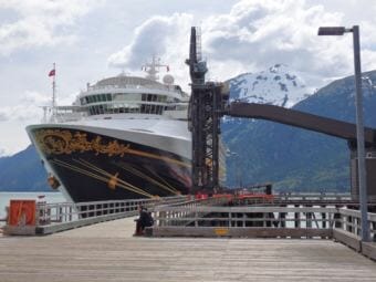
The Star Princess was rerouted to Haines Tuesday morning. (Photo by Emily Files/KHNS)

A rockslide early this morning near the north end of Skagway’s largest cruise dock will close the railroad dock for the rest of the day, the dock’s operator said in a statement.

The slide occurred about 3 a.m., according to a statement from White Pass and Yukon Route Railroad.

After geotechnical engineer assesses the situation, White Pass will decide whether to proceed with ship dockings Wednesday.

This is the second slide near the railroad dock in just a couple weeks. The other rockfall took place Aug. 26.

Four ships were expected in Skagway today.

Two of them, the Star Princess and Solstice, were forced to re-route after the slide. The Star Princess now is docked in Haines, which was expecting no ships today.

The Skagway Assembly is expected to discuss the slide hazard at the railroad dock during its meeting this Thursday.

Cruise ship anchor cut to free humpback whale in Southeast

NOAA-trained marine mammal responders collect a sample from the exhalation of an entangled a humpback whale on Sunday, August 27, near the mouth of Tracy Arm, Alaska. (Photo courtesy of John Moran/ NOAA Fisheries)

A cruise ship in Southeast Alaska cut its anchor free Sunday to release a humpback whale tangled in the ship’s anchor chain.

The National Oceanic and Atmospheric Administration said numerous whales were bubble net feeding in Holkham Bay near Tracy Arm, about 45 miles south of Juneau early Sunday morning.

One humpback struck the ship Wilderness Explorer and became caught in the anchor line about 2:15 a.m.

The Wilderness Explorer is 186 feet long with capacity for 74 guests.

It’s owned by UnCruise Adventures and offers one to two-week tours of Southeast Alaska between June and September.

Company CEO Dan Blanchard said the ship had anchored near Wood Spit about 9 p.m. the night before.

“When the mate came on watch at midnight he noted that there were whales that had moved into the area,” Blanchard said. “We believed they were probably lunge feeding and can’t tell in the dark but one probably lunged and caught the anchor chain as best we can think of.”

NOAA Fisheries was notified of the entanglement just before 3 a.m. and contacted a network of trained specialists.

Alaska Whale Foundation researcher Fred Sharpe and a team of specialists traveled from Baranof Warm Springs to Holkham Bay that morning.

The team used a camera on a long pole to determine the anchor chain was wrapped around the lower jaw of the whale.

Sharpe said the situation was life threatening for the whale and it looked like it had injured itself trying to get free.

“The animal when we got there had been struggling for nearly eight hours and it was just sort of leaning over the chain, kinda draped on it,” Sharpe said. “It was resting. The crew of the Wilderness Explorer had done an excellent job of trying to prevent the animal from being pulled under by the weight of the chain, keep it near the surface and so the animal had the best chance of survival.”

After consulting with entanglement expert Ed Lyman by phone the team decided to cut the anchor chain at the vessel.

That cut was made about 2 p.m. Sunday.

Sharpe said it looked like the whale was able to get free of the remaining chain and he thinks the disentanglement was successful.

The team was able to get DNA samples from the whale’s spout and can learn about the animal’s health and gender.

“The spout is a highly diagnostic health indices,” Sharpe said. “We’ve been working for the past two years with Ocean Alliance collecting spout samples. We can get all kinds of information about stress hormones, reproductive hormones, DNA, potential pathogens, the whole microbiome of the animal. So we have these library of samples of animals that most of them we believe are quite healthy and an animal in distress like this, we can do a comparative analysis and we get some idea of how it might have been impacted by this event.”

Sharpe thinks it is a younger humpback, about 35 feet long, most likely from the Hawaiian population that spends the warmer months in Southeast Alaska.

NOAA Fisheries regional administrator Jim Balsiger said the agency is grateful for the ship reporting the entanglement quickly and the professional response of the Alaska Whale Foundation.

UnCruise’s Blanchard said the anchor is in about 100 feet of water, thinks it can be recovered and the ship can be repaired.

“We’re gonna take it to Ketchikan shipyard on Saturday and have a whole new chain put in and use either our emergency anchor or one we’re having sent up. So we’re gonna be fine either way. We’ll get back down there when the boat goes by and put an underwater camera on it and see what it’s gonna take to get it back up. But, we will plan, or we do plan on retrieving it.”

The ship returned to Petersburg for installation of an emergency anchor after the incident.

Rockslide draws attention to potential hazard looming over Skagway cruise dock

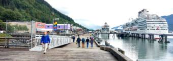
Tourists walk on Skagway’s railroad dock in summer of 2016. The cliff, where a rockslide occurred Aug. 26, is adjacent to Skagway’s biggest cruise ship dock. (Photo by Emily Files/KHNS)

A rockslide near Skagway’s largest cruise ship dock Saturday didn’t injure anyone. But it drew attention to the potential danger of an active slide area neighboring a bustling port.

The dock adjacent to the slide area, called the railroad dock, is owned and operated by the White Pass and Yukon Route Railroad, a major tourist attraction.

The railroad has a train track running down the dock that picks up passengers and takes them on scenic rides.

Towering on the east side of the dock is a steep cliff prone to landslides. On Aug. 25, it rained close to half an inch in Skagway. The next morning at about 6:30 a.m., a rockslide occurred. Two ships, the Volendam and Island Princess, had just tied up to the dock.

“We made the decision to move the ships out of an abundance of care and safety,” said White Pass official Tyler Rose.

The ships were relocated to Skagway’s other two cruise docks. Meanwhile, White Pass reviewed the damage, which Rose says was minimal. A large rock struck and damaged a railing meant to protect the facility.

Rose says in addition to cleaning up the debris, White Pass had geotechnical engineers assess the slide area. White Pass already has fences on the cliff and a catchment in place to shield the dock from slides.

“They’ve done the assessment and basically said the fencing at the upper level served its purpose,” Rose said. “The excessive rains were a large causation…there was obviously an escape that came through there. And the initial analysis was that everything appears fine.”

Rose says the engineers gave the green light for ships to continue tying up at the railroad dock. He says White Pass expects to receive more information from the engineers about whether they should implement additional protections.

“That is an active slide area,” Rose said. “We’ve put mechanisms in place to mitigate that risk, as you can see by the infrastructure that’s been put in that area. We’re monitoring it constantly. We will do what is best to address the safety issues down there because safety is paramount to our organization.”

“It has raised our attention to this issue,” said Skagway Borough Manager Scott Hahn.

Hahn says he’s been approached by some Assembly and community members with concerns about the rockslide. Hahn talked to White Pass on Monday about the engineer’s assessment.

“You never know for sure in any situation, but they felt that it was safe and so that’s good to know,” Hahn said. “I’m also looking into seeing whether we can find someone who does that same type of work in case the Assembly wishes to have a second opinion that.”

Hahn says he would need direction from the Assembly as a whole to seek a second opinion on the stability of the slide area.

For now, Rose says things are back to normal on the railroad dock after the temporary disruption. The dock was scheduled to have at least one ship for the rest of the week following Saturday’s slide.

Site notifications
Update notification options
Subscribe to notifications