
Alaska has the lowest fuel tax yet some of the highest gas prices. We asked Larry Persily, former federal coordinator for Alaska natural gas projects: Why is it so expensive to fill up the tank in Alaska?
Alaska's Energy Desk
State responds to two oil spills at Drift River in Cook Inlet
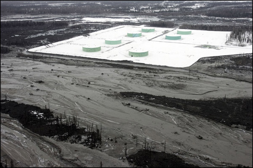
State regulators are monitoring the cleanup of two small oil spills at a storage site on the west side of Cook Inlet.
The spills were discovered at the Drift River Terminal Facility, which is owned by the Cook Inlet Pipeline Company, a subsidiary of Hilcorp Alaska.
Young Ha, of the Alaska Department of Environmental Conservation, says the spills were found after the company began emptying two tanks for a once-a-decade inspection in late June.
Operators mistakenly transferred the oil through a fill line, into the wrong tank.
“Apparently in the past, no one knew that it was actually going into the 20-inch fill line and I guess all this time it was but no one caught that over, it looks like, several decades,” she said.
The company then shut down the tank the oil was being pumped into, without realizing the line still had oil moving through it.
After discovering the problem, operators shut down the line. Then, Ha says they went looking for leaks.
In early July, inspectors found 14 gallons of crude pooled inside a valve box. Then, last week, they found an oil stain covering about 280 square feet of ground.
The company estimates about 28 gallons of oil contaminated the ground, but Ha said that could change.
“You have to really dig it up, dig up the soil. It could be more, it could be less,” she said.
Ha says, so far, there isn’t any evidence that the nearby Drift River was contaminated, or that any wildlife was affected.
Hilcorp bought the facility, and the company from Chevron in 2011. No one from the Cook Inlet Pipeline Company or Hilcorp returned calls on Wednesday.
The company reported that it has already cleaned up the oil from the first spill. Ha says that it will have to dig up and dispose of the contaminated soil found from the second leak.
So far, she says, there isn’t any evidence that the nearby Drift River was contaminated, or that any wildlife was affected.
But, ADEC inspectors will be monitoring the cleanup process and testing on the line to ensure there are no further spills.
Unlikely allies: U.S. and Russia work together on walrus
What brought Soviet Russia and the U.S. together during the Cold War? Walruses.
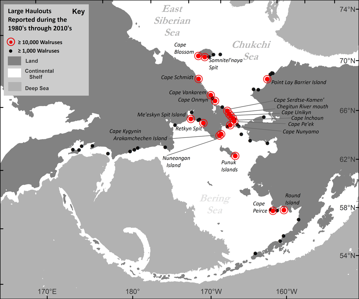
Now a new federal database, created with over a century of information, shows where those animals haul out on both sides of the border. And that’s especially important as sea ice disappears and the animals spend more time on land.
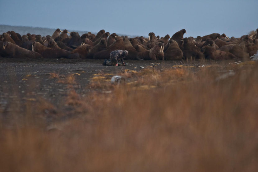
Tony Fischbach says a cacophony of walruses has a lot of bass.
“There’s so many animals there. It really reverberates in your chest, especially when you’re laying in the sand,” he said.
Fischbach is a wildlife biologist with the U.S. Geological Survey. He’s describing listening to more than 10,000 walruses on the beach in Point Lay. When he’s in the field, Fischbach dresses up in an outfit that looks like beach debris to sneak up on the animals to radio tag them.
He says, not too long ago, this spot looked different.
“Well, prior to 2007, we’ve never had large numbers of walruses on the North Western Coast of Alaska,” Fischbach said.
That’s when the sea ice disappeared off the continental shelf of the Chukchi Sea. In the summer, female walruses and their babies spend time offshore hauling out. They float on sea ice to a walrus version of the grocery store, an area full of nutrient-dense food like clams.
But with the melt, they’ve had no choice but to come onshore.
“When they’re onshore, if they get moving, they can develop into a panic, and there can be trampling, injuries and deaths,” he said.
Fischbach says he’s encountered over 100 walruses who died like this, mostly babies.
But this isn’t the only time in history biologists have been concerned about the Pacific walruses. In the 1960s, Fischbach says commercial overharvesting — not melting sea ice — was seen as a potential danger. And to get an idea about walrus population, the United States had to team up with an unlikely ally.
“Even the Cold War was not able to stop this work from happening,” said Anatoly Kochnev in Russian.
Kochnev is the coauthor with Fischbach on the Pacific Walrus Coastal Haulout Database, which holds 160 years worth of information. It’s a historical treasure trove — from old ship logs to joint aerial surveys that happened before the fall of the Soviet Union. Our countries go way back on working together on walrus.
“Walruses are not political and do not respect any political boundaries,” he said.
Knowing that, Kochnev says Russian and American scientists agreed to work together. Our countries collected and shared information on walruses that could shape policy decisions today. All of this when Russia was still a ruled by a Community party.
“In the Soviet era, financing was provided to the scientists and that was provided to do the aerial surveys by plane, and the last one of those was in 1990, and that was the last year the Soviet Union funded the surveys,” Kochnev said.
Since then, Kochnev says Russia has been through some tight economic times, and the funding for projects like this has largely dried up. So, I ask, how is he able to spend months at a time in remote parts of Russia studying walruses? My translator, Elisabeth Kruger, responds to his answer with a laugh.
“He says I know myself how he finds money, and that I don’t need to ask him,” Kruger said.
She works for the World Wildlife Fund. The organization helps pay for Kochnev’s research.
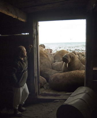
Remember Point Lay — the spot where Tony Fischbach observed over 10,000 walruses hauling out? Just across the Bering Strait is Cape SerdtseKamen’. Kochnev has documented more than 100,000 walruses hauling out there.
And over the years, he says he’s witnessed the effects of climate change firsthand. Polar bears attacking and killing walruses. Something he says biologists hadn’t observed at the haulout before. Just recently, they’ve seen evidence of walruses eating birds.
“That could be an indication that they are finding it more difficult to find food,” Kochnev said. “And that their normal food source is not enough. The walruses predating on birds happened 30 years ago, but it was very rare. Now we’re starting to see it more often.”
Both Kochnev and Fischbach say they hope the haulout database can help illuminate what’s happening to the Pacific walrus. Next year, the feds will decide if the animal should be on the endangered species list. And the database has already received attention from a private company that advises the industry on oil and gas.
Fischbach says the database couldn’t have happened without decades of scientists working across the Bering Strait.
“Even down to the small details,” Fischbach said. “I was having trouble working with the Russian language, representing the Russian script in the database because it’s in Cyrillic. And I’m using Latin script, and the complexity of that on computer systems is really daunting.”
And a Russian scientist — who wasn’t even working on this project — put in the time to lend a hand.
New effort shines a spotlight on ocean acidification in Alaska
Climate change may get all the attention, but it has a less-talked-about but no less troubling twin: ocean acidification.
A growing chorus of Alaskans, from shellfish growers to fishermen, are fretting about the potential impacts to the state’s waters. Now a new collaboration is aiming to bring ocean acidification into the spotlight — with the hope that better understanding it will better prepare the state to adapt.
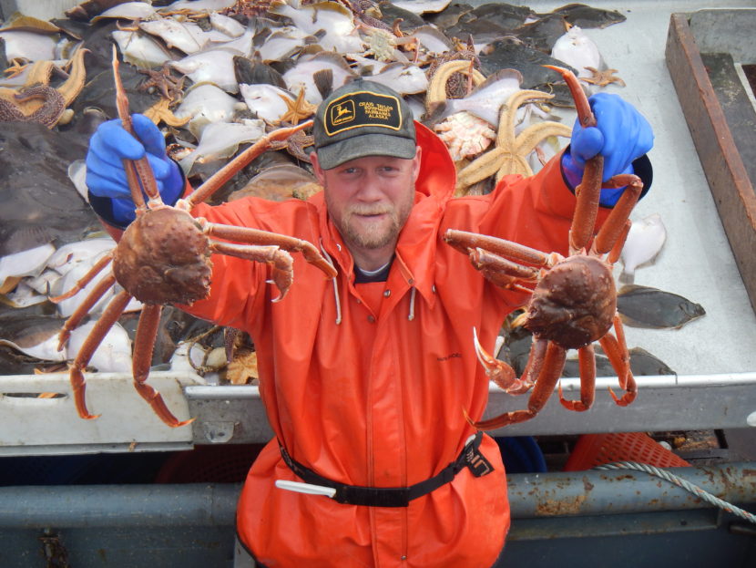
Historically, oceans are basic — that means not acidic. But about a quarter of the carbon dioxide released each year into the atmosphere is absorbed by the world’s oceans. That changes the chemistry of the sea water, making the oceans more acidic. That, in turn makes it harder for ocean-dwellers like crab, oysters, clams, and plankton to form shells — seriously threatening those species.
Darcy Dugan is coordinator of the brand new Alaska Ocean Acidification Network — whose goal is to educate Alaskans and connect scientists across the state. Since the Industrial Revolution, she said, there has been an estimated 30 percent increase in the acidity of waters globally.
“If you assume a “business as usual” scenario for emissions, we’d be looking at the oceans being 150 percent more acidic in 2100,” Dugan said. “That’s also more acidic than they’ve been in the last 20 million years.”
The rapid change may be outpacing sea creatures’ ability to adapt. And Alaska is expected to experience acidification faster and more intensely than its global neighbors because the water here is, as scientists say, ‘cold and old.’ That is, cold water and water from the deep sea is already more acidic.
“These waters naturally store more [carbon dioxide] year round, which means we’re closer to a dangerous threshold to begin with,” Dugan said. “And then as winter storms bring colder water and older water to the surface, the state can intensify.”
Alaska’s Bering, Chukchi and Beaufort seas are all expected to move out of their historic range of variability in the near future. Dugan said the Beaufort Sea is expected to leave its natural range this decade. And that could affect Alaskans’ way of life — because the species most affected by acidification, like plankton, support the state’s most important fish, like salmon
“Right now we have a $5.8 billion seafood industry and the concern is it’s not just commercial species that might be affected by ocean acidification, but the species they eat,” Dugan said. “So once you knock one part of the food chain, the whole food chain could feel the effects.” Plus, she said, about half the seafood in the U.S. comes from Alaska waters.
Dugan hopes a better understanding of the chemistry and ecology of ocean acidification will help the state respond to future changes. That’s where the Alaska Ocean Acidification Network comes in: they are working to connect scientists and communities, from Kotzebue to Sitka, to share best practices for monitoring changes, so the state can respond and adapt to major shifts in the ecosystem.
In August, the Network will host a webinar explaining ocean acidification and its impact in Alaska and present research at the Aleutian Life Forum.
Federal, state researchers map Alaska’s geochemical atlas of rocks and minerals
What’s in the dirt in Alaska?
Federal and state researchers teamed up to make it easier for everyone to find out. For the first time in nearly 40 years, Alaska has an updated atlas of the chemical composition of its earth, rocks and minerals.
The updated geochemical atlas was an outgrowth of another project. Geologists and surveyors were on a mission to find rare earth elements and minerals that could be strategically important to the country.
Melanie Werdon is the acting chief of the mineral resources section of the Alaska Division of Geological and Geophysical Surveys and one of the geological scientists who teamed up with the U.S. Geological Survey, or USGS, to investigate the state’s minerals.
“China was restricting the exports of rare earth elements and they were a large source of that worldwide and it caused an awareness that the United States needs to know more about all of the strategic minerals and metals that it is heavily reliant on for imports,” she said.
That national survey of critical minerals isn’t done yet, but the newly updated geochemical atlas of Alaska was released in June.
The atlas helps determine which parts of the state can be used for metals or mineral production; where the state’s geothermal resources are; and potential geologic hazards to buildings, roads and bridges.
One biologist talked to Werdon about how geochemistry could inform his wildlife research in the northern part of the state.
“He was interested in studying why there were some deformities in moose up there and one of the ideas he had was to look at the chemistry of the area. Look at the alders and see if they had elevated cadmium levels and then tried to correlate that with rocks and moose habitat for eating willows.”
A lot has changed since the last time geologists made a comprehensive map of the state.
Jeff Mauk, a research geologist at the USGS in Denver and one of the authors of the atlas says testing of the soil samples has become more complex.
For example, 50 years ago, labs were well-equipped to test for elements like copper. Now, batteries, cellphones, and laptops require soft metals that were previously unknown.
“Praseodymium, gadolinium, neodymium, those are used in smartphones, for things like speakers and microphones. We weren’t even analyzing for those 50 years ago. We just don’t know about their distribution in the Earth’s crust in Alaska.”
The new atlas isn’t exactly a tell-all book about where to go in Alaska to find things like platinum or gold.
Rather, it maps the distribution of 68 elements that can be found across the state and indicates the mineral resource potential in Alaska.
The atlas also isn’t a comprehensive look at the state’s geology. Mauk says in some areas, it’s difficult to gather reliable data.
“It’s mostly around the Yukon Delta where there’s simply no rocks at or near the surface and because of that there just aren’t a lot of geochemical samples there. Even if there were, it’d be very difficult to interpret, because they really aren’t sampling bedrock. They’re just sampling stuff that’s been washed in from huge distances.”
Mauk says there will be lots of opportunity for researchers to use the maps as a launching point to dig deeper into the dirt.
Why a Bahamas tanker is carrying North Slope crude

A foreign-owned tanker is expected to transport North Slope crude to Asia in the coming weeks. BP has shipped its oil overseas before, but it’s been decades since it was on a tanker built and managed outside the U.S.
State petroleum economist Joyce Lofgren said news about the oil tanker — named Tianlong Spirit — has caused some confusion. She’s received emails from people wondering what all of the fuss is about. They thought Alaska was already able to export crude.
“I don’t think it was the idea of exporting that was the big issue. It was the issue of the foreign flag,” Lofgren said.
Alaska was already exempt from laws that kept other American oil producers from selling overseas. But last year, Congress dropped those restrictions. Now, those companies can sell to foreign refineries, and Alaska producers can transport crude on foreign tankers.
That’s what BP is doing. Tianlong Spirit will haul North Slope crude to Asia and a Bahamas flag is flying from the tanker.
Lofgren said before, if BP wanted to transport crude overseas, it had to use an American-made vessel, staffed with U.S. labor.
“So it’s more expensive, say, than a foreign flagged tanker from the Bahamas,” she said.
BP confirmed its crude is being transported on Tianlong Spirit, headed for an Asian refinery. The company said its own tanker is in dry dock, which is the “primary motivation” for using the foreign flagged vessel.
Lofgren said typically, North Slope crude heads to the West Coast.
“There were some special things happening about that time, and one of them was the maintenance on the North Slope,” Lofgren said. “So there were maintenance issues and some refining issues that made a little more crude available.”
In the past five years, Lofgren said North Slope producers have been selling off their West Coast oil refineries, but she doesn’t think more Alaska crude will make its way overseas.
“You know, I don’t imagine we’re going to see, just my personal feeling, a lot of this because, first of all, Alaska production is so significantly less than it used to be,” Lofgren said.