Arctic

A wilderness guide stumbled upon Alaska’s northernmost glacier — one not marked on any map

The Shublik Mountains stretch parallel to the Arctic coast in March of 2022, about 6 miles from the northernmost glacier in the U.S. (Photo by Matthew Sturm)

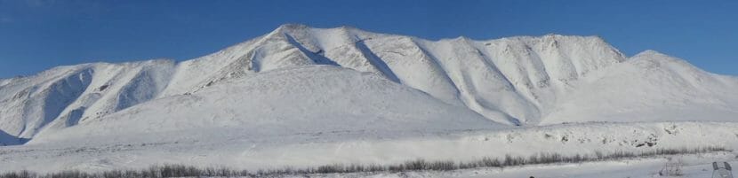
The Shublik Mountains stretch parallel to Alaska’s Arctic coast, with rocky ridges surrendering to miles and miles of North Slope tundra. Talus and boulder fields, as well as occasional short willows, cover the stark landscape, but tucked in between slopes is a glacier — one that, as it turns out, is not marked on a map and is the northernmost in the country.

“Here, in 2022, when it feels like everything has already been discovered, there’s a glacier that doesn’t show up anywhere,” said Zachary Sheldon, who owns Alaska Guide Co. based in Valdez. He was the first person to identify that the glacier wasn’t recorded on a map. “I’m a bit of a glacier nut so it excites me,” he said.

Located at 69.50912, -145.51683, the glacier is 30 miles from the coast and 10 miles northwest of the Brooks Range. According to a USGS publication, glaciers in Alaska haven’t been found north of Brooks Range.

“It is the northernmost glacier in the U.S.,” said U.S. Geological Survey glaciologist Louis Sass. “It isn’t registered or recorded.”

The glacier is around 1/10 of a square mile — or between 50 and 60 acres, said Matthew Sturm, a geophysics professor with the University of Alaska Fairbanks’ Geophysical Institute and the leader of its Snow-Ice-Permafrost Group. Being so small, the glacier is at high risk of disappearing.

“Throughout the world, the smallest glaciers are disappearing due to climate change,” Sturm said. “And here’s this little glacier way up north. … When they were counting the kids in the classroom they forgot to count this little guy.

“It’s just nice to know it hasn’t melted away.”

Discovery

When Sheldon moved to Alaska 15 years ago, he came across the Dictionary of Alaska Place Names, which lists features of the state’s landscape. About 13 years ago, Sheldon started putting all locations from the book into a digital database to catalog the geography of Alaska. Today, the 40-year-old wilderness guide is still working on the same database. He also built a map showing the names of slope runs, the ratings of ice climbs and other details useful to outdoor enthusiasts who want to quickly get a sense of the area.

Last month, Sheldon was tracing the outlines of glaciers so he could have an accurate glacier layer on his map. He was looking at the glacier database and the satellite images from far out. Then he would take a closer look — and that’s how he found the glacier up north.

A screenshot from Caltopo shows the northernmost glacier, which is in the Shublik Mountains and not registered in glacier databases. (Photo courtesy of Caltopo)

Sheldon checked the GLIMS Glacier Database, or the Global Land Ice Measurements from Space, as well as the USGS database and topographic maps but found no record of the glacier.

“This glacier doesn’t exist anywhere, which is what caught me,” Sheldon said.

In the early 2000s, glaciers in this area of the Shublik Mountains were added to the Randolph Glacier Inventory, a global database of glacier outlines, said Sass with USGS. The process relied on fairly coarse satellite imagery, and small features the size of the glacier found by Sheldon show up as 15 by 30 pixels.

“We don’t have the ability to manually verify that the inventory is correct or complete,” Sass said. “This means that the existing inventory is likely missing hundreds or even thousands of glaciers, and likewise, it may be including many features that are not actual glaciers or that are no longer glaciers.”

An effort is underway to improve the global database of glaciers using the higher-resolution satellite images available now, Sass said. However, with such a high volume of data, it isn’t really possible to add a single outline to the existing inventories.

‘We know it’s a glacier’

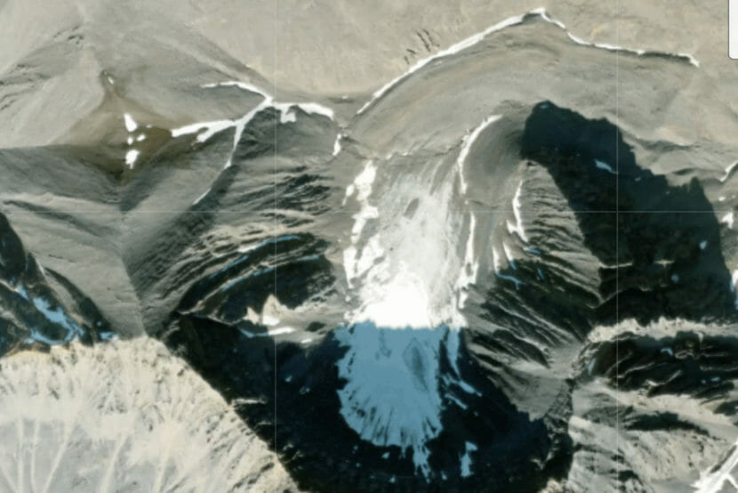
Located this far north, the glacier is probably covered with snow most of the year, so it could have been easy to confuse it with a snowfield, Sheldon said. But the satellite image clearly shows the formation’s glacial features.

The main difference between a glacier and a snowfield is that a glacier is made of solid ice and has internal movement, while a snowfield is made of porous snow and stays in place, said Sturm with the Geophysical Institute.

“The snowfield doesn’t move,” he said. “It changes size, year to year, but it’s just there — there’s no internal flow — whereas glaciers are flowing.”

A satellite image, most likely taken in late summer, shows the lines in the ice of the glacier, indicative of flow, Sturm said.

“The metamorphism of the ice creates foliation like the pages of a book, so we know it’s a glacier,” Sturm said. “If you walked up that thing, you can be walking on what felt like rock most of the way, then you’d walk on glacier ice, then you get to the seedy upper end of it and it’d be snow.”

Most of the glacier is shaded by the mountains, which helps slow the melt. The tongue of the glacier is covered with debris that can also shield the glacier from melting.

The northernmost glacier in the U.S.

What makes the glacier discovery even more exciting to Sheldon is that it’s so far north. While glaciers are not uncommon at much higher latitudes — for example, in Greenland or in Canada — those northern formations are typically surrounded by water that helps them get new snow, Sheldon said.

Sturm said that besides the availability of water sources, better storm tracks also nurture glaciers.

“This is an interesting glacier because it’s neither high nor in a place where there’s a lot of snow,” Sturm said.

But glaciers in the Brooks Range — and north of it — are different from the glaciers farther south in Alaska, Sass said. None of them get much precipitation in the winter, but in summer, the conditions can be fairly wet. And the Saddlerochit and Shublik ranges stick farther north and get slightly more precipitation than ranges farther east, Sass said.

“In the late summer, once the sea ice is out, the north slope of the Brooks Range can be very wet,” he said. “The determining factor for glacier existence up there is whether or not that late summer precipitation falls as snow or rain. That is mostly determined by elevation. That particular feature is only at 4,500 feet, but that is high enough when you are that far north.”

After his finding, Sheldon added the glacier to his map, labeling it as “Northernmost.” He contacted GLIMS, suggesting adding it to their database, but he shared a sense of urgency to do more — for example, to photograph the glacier this summer and take a core sample from it to get it dated.

“Glaciers, 99% of them aren’t growing,” Sheldon said. “Its time is limited.”

This story originally appeared in the Anchorage Daily News and is republished here with permission.

This year’s Arctic Report Card highlights Indigenous perspectives, but is it enough?

An aerial view of Unalakleet in 2019, with open water along the coast. (Photo by Zachariah Hughes/Alaska Public Media)

NOAA’s annual Arctic Report Card, released on Tuesday, shows the changes brought by a rapidly warming Arctic — more rainfall, shorter periods of snow cover, shrinking sea ice and shifting seasons. 

But this year’s report card has something new: a chapter on the consequences of climate change for people who live in the Arctic. It’s a collaboration between scientists, Indigenous knowledge holders and decision makers across Arctic communities in Alaska.

Athena Copenhaver is the executive director of the Study of Environmental Arctic Change. (Photo courtesy of Athena Cophenhaver)

Athena Copenhaver, executive director of the Study for Environmental Arctic Change, said the chapter highlights highlights a different perspective for what is largely a scientific publication.

“It brings in Indigenous knowledge and features the impacts to Indigenous people first and foremost,” she said.

The chapter includes a video, an oral history by the Ahtna Dine’ storyteller Wilson Justin. He describes his experience living with climate change. In the video, he says climate change in the Arctic has already happened, and he reflects on the need for collaboration between scientists and Indigenous knowledge holders going forward.

“The trainwreck already happened. We’re just going to have to figure out how to speak to each other in terms of, not only how we are rebuilding, but what it is we are going to rebuild,” Justin says in the video.

‘We live on that thread of hope’

Indigenous food systems in the Arctic are intimately tied to a cold, icy environment, but the science in this year’s report card shows that those conditions are becoming harder to rely on. In a host of different ways, more rain and less ice are making food sources scarcer and harder to get to. 

The report warns that some climate models predict a shift from a snow-dominated to a rain-dominated Arctic, possible by the end of the century. This year was the third wettest year on record for the Arctic, and precipitation has been increasing across all seasons. Freezing rain is also getting more and more common, even in winter months.

Jackie Qatalina Schaeffer is Iñupiaq from Kotzebue and is the director of climate initiatives at the Alaska Native Tribal Health Consortium. (Photo courtesy of Jackie Qatalina Schaeffer)

Co-author Jackie Qatalina Schaeffer is Iñupiaq from Kotzebue and the director of climate initiatives at the Alaska Native Tribal Health Consortium. She said winter rain events will have a profound effect on Indigenous food security, in part because of their impact on animal foraging. 

“When you have freezing rain in the fall, or in the middle of winter, and it disrupts the food access for caribou, it’s a ripple effect,” Schaeffer said. “It impacts people, it impacts their traditional lifestyle. And then it impacts what’s coming next season.”

Schaeffer believes freezing rain could impact other food sources too.

“It could disrupt the berry season. Or it could disrupt the bird migration because they can’t access food,” she said. 

Five caribou seen up close, with snowy mountains behind them. Three of the caribou are looking straight at the camera.
A group of Western Arctic Herd caribou pause in front of mountains in Kobuk Valley National Park during fall migration in 2016. The Western Arctic herd, one of the largest in the world, has been in decline for the past two decades. The 2022 census shows that the decline is continuing. (Photo by Kyle Joly/National Park Service)

A report this fall cited winter rainfall as one of the causes of the Western Arctic Caribou Herd’s decline.

Sea ice is also changing rapidly, with less in the summer and later formation in the fall. Vera Kingeekuk Metcalf is Yup’ik, originally from St. Lawrence Island, and the executive director of the Eskimo Walrus Commission. She says sea ice — siku in Yup’ik — characterizes the seasons in the Arctic.

Vera Kingeekuk Metcalf, executive director of the Eskimo Walrus Commission, poses in front a map of St. Lawrence Island, where she was born and raised. Metcalf, who is an Yup’ik, now lives in Nome. (Photo courtesy of Vera Metcalf)

“It’s a very powerful presence in our relationship with our world. Here in the Arctic, it really defines our seasons and activities,” Metcalf said. “And right now, here in Nome, we don’t have sea ice yet. And it’s the middle of December.”

Metcalf is also a co-author on the new section. She says changes to the ice are already altering hunting and foraging practices. 

“We’re experiencing more and more sea ice that is weaker. It affects our traditional hunting seasons, which seem to be dissolving and blending together,” Metcalf said.

The report emphasizes an increase in fatal falls through sea, lake and river ice.

“Our hunters are traveling further with less sea ice and what seems more like disruptive stormy weather during some of our hunting trips, ” Metcalf said.

And in some instances, the absence of ice leaves communities more vulnerable to extreme weather events. Lack of sea ice contributed to greater damage across Western Alaska when the remnants of Typhoon Merbok, which was fueled by warmer ocean temperatures, lashed the coast with 50-foot waves and hurricane force winds this September.

Metcalf witnessed the damage to subsistence camps around Nome.

“That just made, you know, devastated coastal camping areas and just changed the environment in a way that we didn’t expect it to happen,” she said.

Two buildings at a fish camp, one badly damaged and the other knocked over
A fish camp in the Nome area, seen on Sept. 24, shows damages wreaked by the remnants of Typhoon Merbok. (Photo by Jeremy Edwards/FEMA)

The storm also caused severe flooding for communities on the coast of the Bering Sea. Power outages caused losses of meat already gathered, boats and equipment were wiped out, and fall hunts were delayed. 

The report also highlights changes that aren’t yet well understood, like the years-long seabird die-off in the Bering Strait region. Many species of ducks, puffins, shearwaters and auklets — important food sources and vital indicators of overall ocean health — have been hit hard by starvation despite their different diets.

Six dead seabirds on a beach. "Nome, 8/16/19" is written in the sand.
A few species of dead seabirds near Nome, Alaska, Aug. 2019. (Photo courtesy of Sara Germain, Alaska Department of Fish & Game)

Despite these profound changes in the Arctic, both Metcalf and Schaeffer said Indigenous values around food prevail despite unpredictable seasons and conditions.

“We don’t say — and we definitely don’t think it and put it out into the universe — that there’s not going to be any berries,” Schaeffer said.  “We hope. We live on that thread of hope that there’s going to be berries, whether they show up or not.” 

‘Living the environment’

For Schaeffer, the addition of this new chapter to the Arctic Report Card, and the work of the Study of Environmental Arctic Change in general, is a way to infuse more of that hope into conversations about climate change in the Arctic. 

“The narrative, if you just focus on the science and the monitoring, could be very scary,” she said. “And we don’t want people to be scared.”

This year’s report card is a step towards integrating Indigenous knowledge with science. But Metcalf says that doing so is challenging.

“How this actually happens can be complicated because Indigenous knowledge and science should not be used, for example, to verify each other,” she said.

But Metcalf says more on-the-ground observations from Indigenous knowledge holders will only strengthen the science. 

“Our own experts are living the environment, or they’re seeing the changes happening in our waters and our lands, often are the first to report these unusual changes to this environment,” Metcalf said. “The longtime people that have been there are experiencing these changes for many years.”

Metcalf sees the new chapter as an encouraging step towards exchanging more information across different knowledge systems.  

“The Arctic is our home. And it’s very eternal and very sacred to us, for those of us that live here,” she said. “Perhaps, collaborating on co-production of knowledge and research is simply another way that we are adapting.”

Alaska’s Arctic waterways are turning orange, threatening drinking water

A river running orange with orange brush on its bank and bare hills in the background.
Tributary of Kugururok River located in Noatak National Park and Preserve, Alaska with orange water. (Jon O’Donnell/National Park Service)

Dozens of once crystal-clear streams and rivers in Arctic Alaska are now running bright orange and cloudy, and, in some cases, they may be becoming more acidic. This otherwise undeveloped landscape now looks as if an industrial mine has been in operation for decades, and scientists want to know why.

Roman Dial, a professor of biology and mathematics at Alaska Pacific University, first noticed the starkest water-quality changes while doing field work in the Brooks Range in 2020. He spent a month with a team of six graduate students, and they could not find adequate drinking water. “There’s so many streams that are not just stained, they’re so acidic that they curdle your powdered milk,” he said. In others, the water was clear, “but you couldn’t drink it (because) it had a really weird mineral taste and tang.”

Dial, who has spent the last 40 years exploring the Arctic, was gathering data on climate-change-driven changes in Alaska’s tree line for a project that also includes work from ecologists Patrick Sullivan, director of the Environment and Natural Resources Institute at the University of Alaska Anchorage, and Becky Hewitt, an environmental studies professor at Amherst College. Now, the team is digging into the water-quality mystery. “I feel like I’m a grad student all over again in a lab that I don’t know anything about, and I’m fascinated by it,” Dial said.

Most of the rusting waterways are located within some of Alaska’s most remote protected lands: the Arctic National Wildlife Refuge, the Gates of the Arctic National Park and Preserve, the Kobuk Valley National Park and the Selawik Wildlife Refuge.

Orange water meets clear water at the confluence of two Arctic streams.
Mainstem of Kugururok River located in Noatak National Park and Preserve, Alaska. (Jon O’Donnell/National Park Service)

The phenomenon is visually striking. “It seems like something’s been broken open or something’s been exposed in a way that has never been exposed before,” Dial said. “All the hardrock geologists who look at these pictures, they’re like, ‘Oh, that looks like acid mine waste.’” But it’s not mine waste. According to the researchers, the rusty coating on rocks and streambanks is coming from the land itself.

The prevailing hypothesis is that climate warming is causing underlying permafrost to degrade. That releases sediments rich in iron, and when those sediments hit running water and open air, they oxidize and turn a deep rusty orange color. The oxidation of minerals in the soil may also be making the water more acidic. The research team is still early in the process of identifying the cause in order to better explain the consequences. “I think the pH issue” — the acidity of the water — “is truly alarming,” said Hewitt. While pH regulates many biotic and chemical processes in streams and rivers, the exact impacts on the intricate food webs that exist in these waterways are unknown. From fish to stream bed bugs and plant communities, the research team is unsure what changes may result.

The rusting of Alaska’s rivers will also likely have an impact on human communities. Rivers like the Kobuk and the Wulik, where rusting has been observed, also serve as drinking water sources for many predominantly Alaska Native communities in Northwest Alaska. One major concern, said Sullivan, is how the water quality, if it continues to deteriorate, may affect the species that serve as a main source of food for Alaska Native residents who live a subsistence lifestyle.

The Wulik River terminates at the village of Kivalina, a community of just over 400 people, 80 miles north of the Arctic Circle, that relies on the river. “We are always worried about drinking water,” said Tribal Administrator Millie Hawley, adding in a written message that her friends and neighbors fish for trout in the river year-round. The community has seen the river become increasingly turbid in recent years, she said, and some people blame the nearby Red Dog Mine. But Hawley said everyone is aware that the permafrost around them is melting, and that increased erosion is causing the level of dissolved minerals and salts in the Wulik to rise.

In addition to present-day impacts, the researchers are also considering the historical record. “I’m sure it has happened (previously),” said Dial, “because, in some sense, this is a natural phenomenon.” But Dial and Sullivan note that the rate of climate warming is greater than anything recorded in the past. “So, it’s very possible that something like this has happened before, but it happened really slowly. And maybe there wasn’t just this massive pulse of orange that wound up in these streams,” Sullivan said.

The team believes there could be more than one climate change-related factor at play. 2019 and 2020 — two of the warmest summers on record — were both followed by winters with unusually high snowpacks. “Snow is a great insulator of soils, and it can be a potentially potent driver of permafrost thaw,” said Sullivan. He likens it to adding an extra blanket to the ground before it freezes. For now, none of the researchers know for sure whether the orange streams and rivers are an anomalous occurrence, coinciding with a handful of unseasonably warm seasons followed by high snow pack. And only time will tell how long it might continue.

This story originally appeared in High Country News and is republished here with permission.

Emily Schwing is a reporter based in Alaska. Find her on Twitter @emilyschwing. Email High Country News at editor@hcn.org or submit a letter to the editor. See our letters to the editor policy.

Arctic Report Card 2022: Rapid climate change brings extreme events to the North

Two buildings at a fish camp, one badly damaged and the other knocked over
The remnants of Typhoon Merbok destroyed hundreds of miles of Alaska’s western coast in September, including this fish camp in the Nome area. The disaster is directly tied to climate change. (Photo by Jeremy Edwards/FEMA)

Human-caused climate change is rapidly transforming the Arctic, and Arctic residents are now coping with effects more characteristic of other regions, like typhoons, wildfires and increased rain.

Those were some of the findings of the annual Arctic Report Card, produced by the National Oceanic and Atmospheric Administration. NOAA Administrator Richard Spinrad said the changes are visible in diminished sea ice, plankton blooms, mass seabird die-offs, coastal erosion and damage to Arctic communities.

“I cannot overstate this, but rapid warming in the Arctic is profoundly affecting the more than 400,000 Indigenous people who live there, and in many instances is upending their entire way of life,” said Spinard.

This year, for the first time, the Arctic Report Card has a chapter on the impact to Indigenous people. Jackie Schaeffer, climate initiatives director at the Alaska Native Tribal Health Consortium, is one of the authors.

She said Native people are seeing in their lifetime the kind of change that used to occur over many generations. Schaeffer, who is originally from Kotzebue, said the fact that her people have endured is a reason for optimism.

“That I could still fill my freezers and eat the food that my ancestors have eaten for 20,000 years is hopeful,” she said. “I want to make sure that that partnership with science is there so that for the next 500 generations, we have that same hope.”

The Arctic is warming more than twice as fast as the rest of the world, and the Arctic report card documents a variety of indicators. In the past year, Arctic surface air temperatures were the sixth warmest since 1900. The report card authors say the last seven years are collectively the warmest seven years since the start of the last century.

Utqiagvik reaches record-high 40 degrees in December

View of the Chukchi Sea from the Utqiaġvik coastline Oct. 26, 2018. (Ravenna Koenig/Alaska’s Energy Desk).

This time of year, Billy Adams would expect to see sea ice lining Utqiagvik’s Chukchi Sea shoreline. But right now, it’s all open water.

“It was raining before Thanksgiving, and then it rained again, and it’s December,” Adams said.

Adams lives in Utqiagvik and is an observer for the Alaska Arctic Observatory & Knowledge Hub, a coalition of northern communities that shares data about sea ice, wildlife and coastal waters.

In past winters, Adams said the weather might warm up for a week before returning to below zero temperatures. But this year is different.

“The last few months have been very unusually warm and wet, and a lot of snow,” Adams said.

Temperatures in Utqiagvik broke 40 degrees on Monday, the highest ever recorded for the North Slope community in December. The unusual warm spell was driven in part by climate change, said climatologist Rick Thoman with the Alaska Center for Climate Assessment and Policy.

“The open water at this point the first week in December in the Chukchi Sea, that is a very clear climate change signal,” Thoman said.

The latest jump in temperatures stems from a combination of warm air and rain moving north from the Bering Sea, plus the lack of Arctic sea ice.

“That exposed water is basically acting as a heating pad, putting out that heat into the polar atmosphere,” he said.

Thoman said 40 degrees is the highest temperature recorded in Utqiagvik between Oct. 30 and April 22 in more than a century of monitoring.

The North Slope has seen progressively warmer winters in recent years. As of yesterday, Thoman reported, ice coverage in the Chukchi Sea was the ninth lowest on record for the date.

Temperatures ranged in the upper 30s and low 40s across the North Slope Monday.

Adams said he’s concerned about what the spike could mean for caribou, an important subsistence animal. Warm weather tends to bring lots of snow, which he said makes it difficult for caribou to find food in the tundra.

“We have to keep an eye out in the next few weeks, next few months,” he said. “And we hope to see that animals are still around.”

A NOAA weather forecast shows temperatures in Utqiagvik are expected to drop into the teens and single digits by the end of the week.

The bottom of the Bering and Chukchi seas could become too warm for some important species

A tan basket star illuminated on the seafloor
A basket star is seen on the Alaska seafloor. If ocean warming continues on its current trajectory, marine life at the bottom of the Bering Sea and Chukchi Sea will look a lot different in the coming decades, according to a new study. The seafloor environment will be too warm for the snails, worms, clams and mussels that make up the diets of walruses and some seabirds and fish species. But basket stars like this one and related brittle stars — species that do not currently play much of a role in the food web — are expected to thrive in the warmer temperatures. (Photo provided by NOAA Alaska Fisheries Science Center)

There is danger lurking on the floor of the Bering and Chukchi seas for mussels, snails, clams, worms and other cold-water invertebrates, according to a new study led by National Oceanic and Atmospheric Administration scientists.

If climate change continues its current trajectory, the Bering and Chukchi seafloor areas will be too warm for those creatures by the end of the century.

In turn, that means trouble for walruses and other marine species. Snails and mussels are particularly important to commercially harvested fish like halibut and yellowfin sole, along with being prey for the Pacific walruses that gather in the summer in the northern Bering and southern Chukchi seas. The Bering Sea is part of the North Pacific Ocean south of the Bering Strait that separates Alaska from Russia, while the Chukchi Sea is part of the Arctic Ocean just north of the strait.

The results warn that those seafloor-dwelling populations of invertebrates that support populations of Bering Sea and Chukchi Sea marine mammals “may be seriously impacted by future ocean warming,” the study said. That also affects coastal residents who depend on traditional harvests of walruses and seabirds for food and cultural connections, the study said.

Under the current climate trajectory, key cold-water bottom-dwelling prey species are on track to lose half of their suitable habitat by mid-century, the study said. By the end of the century, almost the entire Bering and Chukchi sea region would be too warm for them to live on the seafloor there, the study found.

The resulting seafloor habitat would be taken over by a few species that can tolerate a wide range of temperatures – creatures like brittle stars and basket stars, relatives of sea stars. But those marine species are very minor players in the food web.

The study is a cooperative effort of scientists from NOAA’s Alaska Fisheries Science Center, NOAA’s Pacific Marine Environmental Laboratory, the University of Washington and the Institute of Marine Research in Norway.

A walrus in close-up, with open water and ice in the background.
A young bull walrus rests on a piece of sea ice in Alaska waters on April 13, 2004. Walruses eat clams, mussels, snails and worms that live on the seafloor. Projected ocean warming threatens those food supplies and may force walrus populations farther north. (Photo by Joel Garlich-Miller/U.S. Fish and Wildlife Service)

It uses a decade’s worth of data to calculate the preferred temperatures for a variety of species that dwell on the bottom of the sea in areas of the Bering and Chukchi that normally have seasonal ice coverage.

In the past, that data has been used to understand fish and crab populations that are important to the commercial seafood industry. The new study, however, used the data to examine the prospects for sometimes overshadowed bottom-dwelling species. That makes it the first examination of climate-change impacts on the entire suite of invertebrates living on the seafloor environment there, said lead author Libby Logerwell of NOAA’s Alaska Fisheries Science Center.

The prospects appear grim for most of them – and for the species that need them for food.

“The climate models under this ‘business-as-usual’ climate change scenario project that the thermal habitat for all but the few most heat-tolerant arctic invertebrates will shrink dramatically northward by the end of the century,” Logerwell said by email.

The species that would benefit account for only about 8% of the animal groups currently in the environment, the study said.

Because the study projects into the future, its findings do not explain the recent crash in Bering Sea crab stocks, Logerwell said. The “thermal habitat” for crab still exists through much of the Bering, she said. However, long-term prospects appear to be poor if climate change continues on its current trajectory. Habitat with suitable temperatures for crab species is likely to move farther north, she said.

The study was published in the journal Deep Sea Research Part II: Topical Studies in Oceanography.

This story originally appeared in the Alaska Beacon and is republished here with permission.

Site notifications
Update notification options
Subscribe to notifications