Kavitha George, KTOO

Federal Gulf cod fishery likely to close as warming waters push cod numbers to lowest on record

Miles sits in the galley of his boat, the Sumner Strait. (Photo by Kavitha George/Alaska’s Energy Desk)

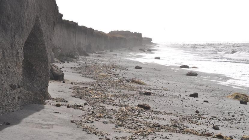
The latest Gulf of Alaska trawl survey shows the lowest cod numbers on record. That threatens to close the federal Gulf cod fishery which was slated to begin in less than two months. Cod numbers have been declining for four years, and in Kodiak, just a handful of fishermen are still going after them. It’s another example of how climate change is threatening coastal livelihoods.

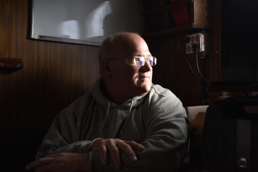
Sixty-year-old Frank Miles has fished for cod around Kodiak since he was a teenager.

“Started out at the age of 15, in an open skiff, back when salt cod was a staple,” he said. “I think I’ve missed one cod season in 44 years.”

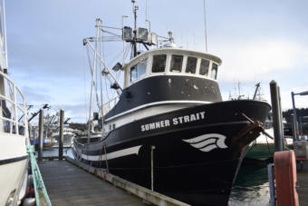
Miles eventually graduated from an open skiff to a 58-foot vessel called the Sumner Strait. Sitting in the galley on a rare sunny afternoon in Kodiak’s harbor, Miles takes a break from getting his boat ready for the January cod season.

He has been around long enough to see fisheries cycle in and out, from the decline of king crab in the 1980’s to the rise of groundfish like pollock, sablefish and cod.

Frank Miles’ pot and longline vessel, the Sumner Strait. (Photo by Kavitha George/Alaska’s Energy Desk)

“If you look back just 10 years ago,” he said. “I mean, goodness, we used to fish eight months out of the year on just cod — me, personally.”

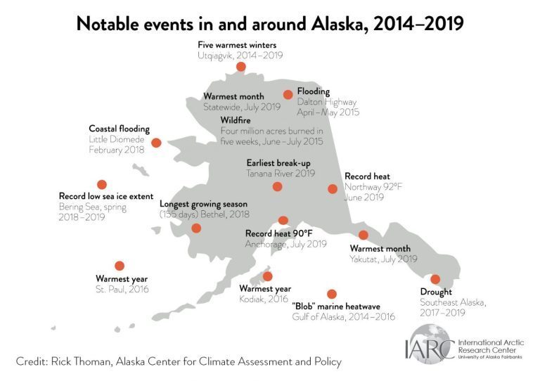
Everything changed with the emergence of a massive marine heat wave across the Pacific Ocean, commonly known as the “Blob.” Between 2014 and 2016, surface ocean temperatures rose four to five degrees Fahrenheit, and cod started to disappear.

From the last peak in 2014, the level of mature, spawning cod crashed by more than half in the Gulf, according to stock assessment data. From 113,830 metric tons in 2014 to 46,080 metric tons in 2017.

Cod is a major driver of Kodiak’s winter economy, so when the Blob subsided in 2017, fishermen hoped the fishery would bounce back.

Steve Barbeaux, a fisheries research biologist for the National Oceanic and Atmospheric Administration, said cod larvae did start to show up again. But this year brought signs of a new marine heatwave, and once again, those young fish seem to be declining, or disappearing altogether.

Barbeaux said the effects of each climate change-driven heat wave are delayed. Cod only enter the fishery at age three, so what we’re seeing right now is still largely due to the last Blob.

“I would say we still [have] a pretty big hangover from the first heat wave. So a lot of the impact on the population was due to that first heat wave that we haven’t recovered from,” he said.

As for what’s happening with the second heat wave?

“We don’t know yet. The impact of this heat wave won’t happen for another three years when the fish enter the fishery,” he said.

And though cod could still bounce back with the right conditions, with a new heat wave brewing, things might get worse before they get better.

“What we’re looking at in 2019 is — it just got really warm — which for the 2019 year class, that means that the eggs didn’t survive,” he said. “If it gets above a certain temperature, cod eggs don’t do well.”

One theory is that cod are moving north into colder Bering Sea waters. But Barbeaux said looking at genetic studies in the region, that’s probably not the case.

“The Gulf of Alaska doesn’t really work that way. To move north, [fish] actually have to move south first. And if we look at the genetics for cod, we don’t see a lot of mixing out in the Aleutians with Gulf of Alaska cod.”

Barbeaux said Gulf cod would have to be drawn by food or ocean currents to move south toward the Aleutians, but “the currents don’t go that way.” On top of that, he said they haven’t seen any increase in the southeast Bering Sea cod population.

Barbeaux’s latest stock assessment found cod at less than a third of 2014 levels — 33,274 metric tons —  with few new eggs. These are the lowest numbers scientists have ever documented for Gulf cod.

They’re now below the federal threshold that protect cod as a food source for endangered Stellar sea lions. As soon as the population dips below that line, the fishery closes.

The whole federal cod fishery in the Gulf would be shut down for the season in January.

The assessment is still under review by the North Pacific Marine Fisheries Council, but if everything checks out, that decision could be announced early next month.

For many Gulf communities, the precipitous decline in catch values, and the potential for a closed fishery threaten not only fishermen, but processors and other support industries. And climate science suggests this might be the new normal.

Mike Litzow is a NOAA fisheries ecologist based in Kodiak. He and other scientists are worried about whether cod will ever bounce back in a region so affected by climate change.

“We’re just well beyond what we’ve ever seen before, and it’s this very unusual, warm event,” Litzow said. “Our best understanding is that this is going to be the new average within a short time frame.”

Darius Kasprzak, a jig fisherman, sits down for coffee near the Kodiak harbor. (Photo by Kavitha George/Alaska’s Energy Desk)

Given how bad the last few years have been for Gulf cod, it’s difficult to find Kodiak fishermen still planning to fish the upcoming season — most have moved on to other fish, new waters, and even different lines of work.

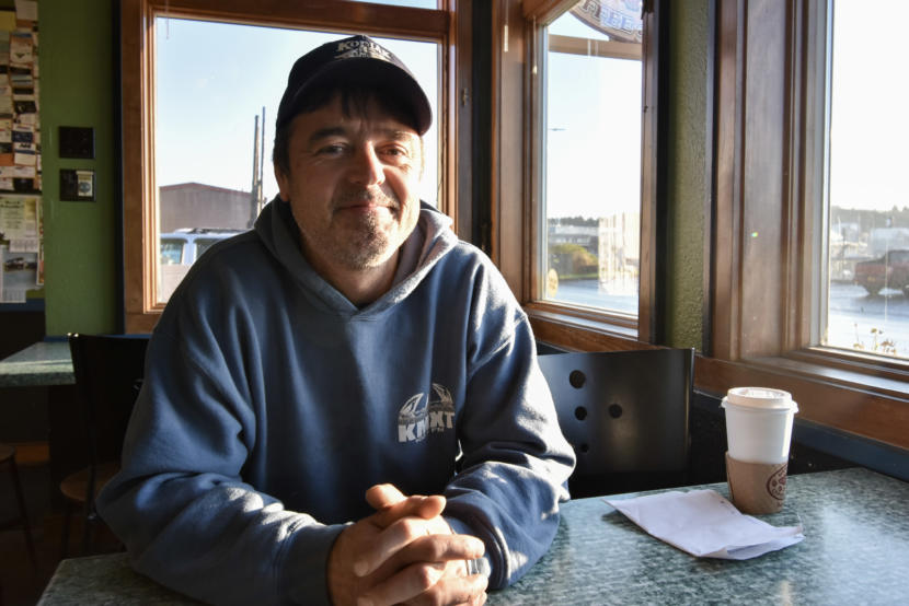
Darius Kasprzak is a jig fisherman who used to make most of his living on cod. Sitting down for coffee on a Saturday, he explains why he was too busy for a weekday interview.

“I have to do other gigs like right now I’m working on a tugboat, I work as a skiff man on a salmon boat during the months of August and September. I have to fill in some other stuff to make a yearly livelihood now that I can’t fish cod year round.”

His last good season fishing Gulf cod was six years ago, he said, and the alternatives — switching gear types, or heading out the Bering — just aren’t for him.

Back aboard the Sumner Strait, Frank Miles knows he’s among a handful of Kodiak fishermen still trying to make it on cod. Like Kasprzak, Miles has worked to diversify. He’s fishing Tanner crab and halibut too, but he’s hoping for cod — if not for him, then for younger fishermen.

“I’m more worried about my son and his generation, the younger guys coming up. I’m 60, you know, I’m probably just about done,” he said. “I’d like to think that I could fish cod one more time before I retire, but I don’t know. I simply don’t know where we’re going here.”

Even with the 2020 season looking so murky, Miles is going ahead with preparations, getting his boat fixed up and his pots re-webbed and ready to catch some cod.

New UAF climate report highlights rapidly changing Alaska ecosystems

Bering Sea storms battered Port Heiden’s coast in October 2017. (Photo courtesy of Jaclyn Christensen)

Alaska has been breaking so many climate records over the last five years, it suggests the state has crossed a threshold into increasingly rapid ecosystem changes.

That’s according to a new report by Rick Thoman and John Walsh, scientists at the International Arctic Research Center at the University of Alaska Fairbanks.

“When you cross these thresholds, some of which we don’t know what they are until they happen, that you get these very rapid changes,” Thoman said in an interview on Wednesday.

The report highlights increasingly intense wildfires in the western U.S., rapidly declining sea ice and warming winter temperatures.

But there are more specific measures of climate change too. The year 2019 saw the earliest ice breakup on record on the Tanana River. Southeast Alaska’s rainforests have experienced multiyear drought. Tundra on the North Slope is greening, and widespread algal blooms have been showing up in warming coastal waters.

As the report points out, all of these have significant impacts on Alaska communities. Whole villages have been forced to migrate due to erosion. Subsistence resources have become more unreliable. And state agencies have been forced to adapt to new federal regulations.

Some of the climate records Alaska has broken over the last five years. (Graph by Rick Thoman/Alaska Center for Climate Assessment and Policy)

Thoman said the effects of climate change in northern latitudes are more apparent than in the Lower 48, a phenomenon called “Arctic amplification.”

“That is, very largely, the result of changes in sea ice,” he said. “Also, changes in snow cover on land over most of the high latitudes.”

It’s basically a worsening cycle. Shorter sea ice and snow seasons mean there’s less ice and snow to cool the air and the land, so the impacts of warming trends are more apparent. And Thoman said the extra water vapor in the air — a result of the warming atmosphere — acts like a greenhouse gas to trap in heat.

Even within Alaska, the effects of climate change are varied, Thoman said.

“In places like Southeast, especially southern Southeast, temperatures are responding much closer to what we’re seeing in Washington state, for instance, as opposed to on the North Slope, where the sea ice changes are so dominant. Temperatures are warming almost three times the rate that they are in southern Southeast,” he said.

Thoman and Walsh’s report also talks about how Alaska communities are responding to the changes. So far, many of the plans are mitigation strategies. But Thoman said that’s not really enough.

“Most of them are, ‘How do we protect our community when some bad weather event happens?’” he said. “But we are seeing more and more (communities) start to address the bigger issues, understanding that this is a global problem. It’s not going to be solved by one community not doing plastic bags at the store anymore.”

The climate report used published data from the National Oceanic and Atmospheric Administration and climate science researchers. Thoman said they’re hoping to make this report one in a series covering the impacts on communities and expectations for the future.

Who will be the fattest Katmai brown bear? Forget Beadnose, Holly is like the ‘Michelin Man.’

Bear 435 Holly, aka “Michelin Man.” (Public domain photo by Naomi Boak/Katmai National Park and Preserve)

As local elections wrap up around the state, a more whimsical type of voting is getting started this week.

A dozen brown bears in Katmai National Park and Preserve are competing for the title of fattest bear during the park’s annual Fat Bear Week, and this year, rangers are using 3D imaging to find out precisely who’s fattest.

It started out as Fat Bear Tuesday.

Former ranger Mike Fitz noticed a Facebook comment marveling at a brown bear’s summer weight gain, and “a light bulb popped into my brain,” he said. “And I thought, you know, wouldn’t it be kind of fascinating and fun if we have the online audience decide who they thought was the fattest bear.”

Five years later, it’s expanded into a weeklong, March Madness style bracket, with thousands of people around the globe weighing in to crown one hefty bear the winner. Summer “bear cams” hosted by Explore.org attract 19 million viewers from around the world — day one of the bracket saw more than 13,000 voters.

Fitz said the wildly popular competition has helped put Katmai on the map and highlight the need to protect the bears’ habitat.

https://www.facebook.com/KatmaiNPP/posts/2738724166152364

Brown bears on Katmai’s Brooks River spend all summer bulking up on sockeye in preparation for winter. Some end up over a thousand pounds, and many yearlings can literally double in size, according to Katmai Conservancy media ranger Naomi Boak. She helped pick the contenders this year.

“It’s an equal opportunity competition,” Boak said. “It’s not just the gigantic boars that are in this competition, but the single sows and sows with cubs and spring cubs and subadults and yearlings.”

The winner of Fat Bear Week will be announced on Oct. 8. (Public domain photo by K. Stenberg/Katmai National Park and Preserve)

Last year’s infamous winner — a half-ton sow named Beadnose — hasn’t shown up around Brooks River this year, or as Boak puts it, “She has declined to participate.”

But Boak said other well-known contestants are looking promising. “We have a sow, 435 Holly, who looks like the Michelin Man. She has been nonstop snorkeling,” she said. “And she is huge. She is definitely a top contender.”

That’s not to say that Holly doesn’t have some weighty competition.

“Bear 480 Otis, who is perhaps our most famous bear. He’s won this competition twice,” Boak said. “He’s competitive. He is the hardest working bear on the Brooks River.”

Bear 480 Otis, “the hardest working bear on the Brooks River.” (Public domain photo by Naomi Boak/Katmai National Park and Preserve)

More so than Holly, you ask?

“I’d say more so than Holly,” Boak said, before correcting herself. “I mean, he’s … I don’t know. I’d say they’re equally diligent in their work of getting fat.”

Like always, the ultimate winner will be decided by popular opinion. But this year, rangers are bringing in scientists to find out who’s actually the fattest.

Joel Cusick is a geographic information system specialist with the National Park Service. He’s used to surveying parks buildings and archaeological sites.

But on an assignment in Katmai this summer, he thought, “Why not bears?”

Cusick’s scanner bounces laser beams off the bears to determine their volumes. The tricky part, he said, is finding one that will stay still long enough to get an accurate reading.

“A scanner has to pass by the bear several times, if not hundreds of times, and paint the bear with points of light,” he said. “It requires about 16 seconds to pull this off on a very fast scanner.”

https://www.facebook.com/KatmaiNPP/posts/2725795160778598

With the help of bear biologists familiar with the animals’ body compositions, Cusick used the volume measurements to estimate weights. He’s not pretending that the findings are perfect, but his report said they’re accurate within about 50 pounds.

In any case, it’s far easier than the traditional method of darting a bear with a tranquilizer and stringing it up to clock its weight.

“The ideal situation (would be to) get this giant scale put out there, have the bear stand on the scale and scan them,” Cusick said. “That opportunity did not arise.”

This is the first season the park has done 3D bear scans, but Cusick said it could be used in the future to compare spring and fall weights — indicators of the bears’ overall health.

Cusick is sworn to secrecy on the weights of this year’s contenders until Tuesday, Oct. 8, when the winner of Fat Bear Week is announced.

https://www.facebook.com/KatmaiNPP/videos/927297960981068/

Kodiak villages prepare for reduced ferry service this fall and winter

The MV Tustumena docked in Kodiak.
The MV Tustumena docked in Kodiak. It’s the smaller of two ferries that service Kodiak Island. (Photo by Kavitha George/KMXT)

Like many parts of coastal Alaska, Kodiak Island is gearing up for a gap in ferry service this winter. While the city of Kodiak has relatively reliable alternatives for transportation to the mainland, the gap will pose serious difficulties for the some of the island’s outlying villages.

The six coastal villages of Kodiak are remote under any circumstances. All require a bush plane or a boat to reach, and only three receive ferry service at some point in the year. A winter gap in ferry service is standard practice.

But this year’s gap is significantly longer.

Ouzinkie and Port Lions, on the northeast end of the archipelago, will be cut off for three months between January and April. Old Harbor’s last ferry of the year was last week.

Ferries are a cost-effective way for village residents to do the everyday things you’d use a vehicle to do in a larger city: picking up groceries, getting a car to the mechanic, moving building supplies. Residents often schedule their lives around ferry service.

Ouzinkie Vice Mayor Katherine Panamarioff said kids in her village rely on ferries to travel to school sports competitions, and many elders need them to get to doctors’ appointments in town.

“I just had to take my mother in a ferry on Monday. She would not fly,” Panamarioff said. “There are some people that will not fly, and so that’s their only way of getting to and from either Kodiak or Homer.”

The alternatives — chartering a boat or a plane — are significantly more expensive. And particularly in winter, Panamarioff said ferries are just more reliable.

“A lot of times, you can’t even get in and out of the community because the weather is so bad,” she said. “The wind is really bad, and the flights cancel. And it’s like that weeks at a time.”

Last month, the Alaska Legislature and Gov. Mike Dunleavy cut $43 million out of the Alaska Marine Highway System budget — a 31% cut from previous years, according to the Alaska Department of Transportation and Public Facilities. As a result, AMHS has had to significantly constrain its sailing schedule.

But another reason for the gap in service is that both the Tustumena and the Kennicott — the ferries that typically serve the island — are scheduled to be in overhaul at the same time this year.

According to Transportation spokesperson Meadow Bailey, that happens every year, but this year “there’s a longer period of time, because there’s more overhaul that needs to be done, like more work that needs to be completed in that time frame.”

The Kennicott, the larger of the two ferries, goes offline in early October. And that means that the whole island will be relying on the smaller Tustumena, until it too stops running in January.

AMHS ferry Kennicott in Ketchikan
Alaskan Marine Highway System ferry Kennicott in Ketchikan, Aug. 29, 2010. (Creative Commons photo by Jay Galvin)

Port Lions Mayor Dorinda Kewan worries that without the Kennicott handling the heavy traffic from the city of Kodiak to the mainland, village residents will have to compete for space to book vehicles on the Tustumena.

“So the traffic that would normally have been going between Homer and Kodiak on the Kennicott is going to book itself on the Tustumena, so we are going to have to plan way in advance if we want to get a space on the Tustumena between Port Lions and Kodiak,” Kewan said.

Adding in the new sliding fare and cancellation fee schedule, Kewan predicts planning routine tasks over the next few months is going to be a logistical headache for passengers in Port Lions or Ouzinkie.

“If we want to do any doctor appointments or dental appointments, we’re gonna need to get those booked,” Kewan said. “So we literally need to know what we’re doing. If we’re going to use the ferry service between now and January, we need to know that by Oct. 1. And we need to book those tickets.”

To some extent, the cuts to service just make ferry travel for village residents more difficult, planning-wise. But Kewan said the longer gap this winter might mean that people end up paying more to fly, with more limited space and no vehicles.

It’s possible, she said, they’ll just have to make do without as many trips to town.

US military exercises come with indications of a growing Navy presence in Alaska

U.S. Navy personnel stand on the flight deck of the USS Comstock, docked in Kodiak, Sept. 10, 2019.
U.S. Navy personnel stand on the flight deck of the USS Comstock, docked in Kodiak, Sept. 10, 2019. (Photo by Kavitha George/KMXT)

The USS Comstock docked in Kodiak on Tuesday, en route to participate in a joint forces military training exercise spread across the Gulf of Alaska and the Aleutians. The visit comes as U.S. Navy officials indicate the possibility of an increased naval presence in Alaska, and what that might mean for the future.

Kodiak’s Pier 2 is used to hosting cruise ships and large crab boats this time of year. So a 600-foot Navy warship was a little out of place on Tuesday.

The USS Comstock, home-ported in San Diego, arrived in Kodiak around noon. For many aboard, including the ship’s captain, Cmdr. Kevin Culver, it was their first time in Alaska. Culver’s crew is making its way north for training, along with several other detachments of the Navy and the Marine Corps.

“We’re one of the first ones here,” Culver said on a tour of the sixth-floor steering room. “So you know, what a better place to stop than Kodiak and wait for everybody else to catch up to us.”

Across Southcentral Alaska and the Aleutians, some 3,000 service members are participating in the joint forces Arctic Expeditionary Capabilities Exercise this month. The exercises range from disaster relief logistics to tactical response drills.

Training in Alaska is a routine activity for naval forces. Northern Edge back in May was a massive joint forces exercise that happens every two years, not to mention the Navy SEALs’ cold weather training facility that operates on Kodiak’s Spruce Cape.

But Alaska might be seeing more of the Navy soon. As sea ice recedes and Arctic waters open up, protecting American interests in the far north is becoming more of a priority.

You might remember back in 2007 when Russian submersibles descended two miles below the North Pole ice cap to plant a flag on the ocean floor. It was more a publicity stunt than a true “claim” to the seabed, but that growing competition for Arctic resources, as well as control of increasingly navigable waterways, is what the Navy wants to get ahead of.

“All the trading nations of the world are going to seek to take that shortcut to the markets,” Rear Adm. Scott Gray told KMXT in an interview May. “So we’ll see an increase in shipping and transportation up here. And so our presence up here is just a continuation to ensure that we protect the sea lanes for trade for all nations and that we are trained and ready to operate in the difficult environment that is the north.”

For that reason, the Navy has begun looking at establishing a more permanent foothold in Alaska, according to Gray as well as Navy representatives in Kodiak this week.

Senior Chief Petty Officer Brandon Raile stands on Kodiak’s Pier 2 outside the USS Comstock, Sept. 10, 2019.
Senior Chief Petty Officer Brandon Raile stands on Kodiak’s Pier 2 outside the USS Comstock, Sept. 10, 2019. (Photo by Kavitha George/KMXT)

“What’s happening is the Navy is looking at its options,” Senior Chief Petty Officer Brandon Raile from Alaskan Command Public Affairs said in an interview on the Pier 2 dock on Tuesday. “We formerly had two installations here in Alaska: Adak and Kodiak. Obviously, we gave Kodiak to the Coast Guard. Adak was turned back over to the Aleut Corporation. So right now we have no basing options here. So in order to be proactive, of course we are looking into what the options are.”

One option might be a strategic port involving the Navy, Coast Guard and Department of Commerce, set up along the Bering Sea, according to a U.S. Naval Institute interview with Navy Secretary Richard V. Spencer in January.

As far as the Navy coming back to Kodiak, Raile said it’s not an impossibility, though there isn’t a clear timeline in place.

“Nothing is off the table at this point,” he said. “We are in the early stages of looking at everything.”

The USS Comstock will be in Kodiak through the weekend. The Arctic Expeditionary Capabilities Exercise wraps up at the end of the month.

Fighting a never-ending battle against coastal erosion on a Kodiak Island highway

Exposed guardrails at Mile 25.5 of the Chiniak Highway. (Photo by Kavitha George/KMXT)

Erosion is an ever-present issue for coastal highways. It’s of particular concern for Kodiak, where a large portion of the major road system sits right alongside the ocean.

Steve Frey is leaning slightly over the edge of a bluff on the Chiniak Highway overlooking Kalsin Bay.

“I wouldn’t lean against this thing too hard,” he said, pressing lightly on the guardrail, “but you can kind of get an idea here, see how the guardrail is actually exposed.”

He’s working at Construction Site 2, 25 miles out from downtown Kodiak. Below him, the thick metal posts holding up the highway guardrails are completely separated from the hillside. The cinder block anchors that secure the posts are visible too.

Frey, a project engineer consulting for the Department of Transportation and Public Facilities, says that normally this whole support structure should be embedded well underground. But an exposed bluff like this is constantly being battered by ocean swells, winds and rain — which steadily eat away at the hillside.

“It’s gradual,” Frey said. “It goes pretty quick once it starts going.”

Erosion along the Chiniak Highway is well-documented in borough reports and government surveys. One 1983 study estimated that the bluffs were receding at a rate of five to seven feet per year, on average.

Aurah Landau, DOT Public Information Officer for the Southcoast Region, says there are two main issues endangering the roadway.

“There’s erosion occurring along the coastal bluff that has steepened beyond the angle causing sliding and slumping next to the highway,” she said. “And then there’s erosion occurring at bridge and stream culvert crossings from flood events.”

With a roughly $10 million price tag, the Chiniak Highway Erosion Control project spans nine separate sites spread out over more than 20 miles along the highway. It’s a months-long operation that’s been on DOT’s docket for years. Landau says the design process took longer than normal due to the scope of the project.

Among the many complicated considerations that go into a project of this scale are making sure new roads or structures comply with borough code, causing as little impact to the environment as possible and ensuring that the construction itself doesn’t cause too much of a disturbance to residents or thru-traffic.

A construction crew prepares a hillside for a blast, in order to move the Chiniak Highway inland at Mile 25.5. (Photo by Kavitha George/KMXT)

Back at Site 2, Jacob Spalinger, a project superintendent for Brechan Construction is standing on a bluff above the eroding highway.

“I think to this ditch line is roughly a 28-foot cut,” he said, pointing to a line of orange explosives markers embedded in the ground.  “Where we’re standing, it’s going to be 28 feet lower where we’re standing.”

In order to move the road inland, the crew has to blast part of the hillside away to level it out. It’s a very precise process involving holes drilled deep into the bluff and then filled with specific amounts of explosives. Brechan cuts off road access for about 20 minutes for each blast, but the explosion itself doesn’t take more than a few seconds.

But even with these careful planning measures, staving off erosion on a coastal highway seems like a losing battle.

“These areas are on a steep bluff, and if erosion continues like it is, it could potentially come impact the road again in the future,” said Garrett Paul, construction project manager with DOT.

Orange markers embedded in the ground will be filled with precise amounts of explosives in order to blast away the hillside. (Photo by Kavitha George/KMXT)

Does that mean workers will be back here blasting hillsides again in 30 or 40 years? It’s tough to tell. DOT says designers took measures to “greatly minimize” future erosion using retaining walls and realigning roadways. In site 2, the road is being moved 35 feet inland onto bedrock, which the project officials say will stand up better to the elements than the loose earth where the road is currently situated.

Should erosion continue to be a problem at other places along the 40-mile highway, the state could face a new problem — running out of room to move the road. That’s because the state’s right-of-way corridor only extends 200 feet out from where the road was originally built.

“Yes we would definitely run out of room,” Paul said. “Generally when we do that we purchase properties to move roads, or get easements to construct roads that are outside of our right of way.”

DOT hasn’t had to buy any private property for this project, though they have purchased several easements from property owners along the highway for things like driveway realignments. All negotiations with property owners are confidential, according to DOT Right of Way Chief Greg Weinert.

“I can say that in general, any time you change someone’s property rights, it’s not generally something they want,” Weinert said. “They may understand that it’s for the public good, but it’s still difficult to have things changed. It may have been fair compensation, but that still doesn’t mean there’s not aggravation on the part of the property owner.”

DOT says the project is currently on track to be completed October 31, 2019, with around 10 more blasts scheduled.

Site notifications
Update notification options
Subscribe to notifications