Ravenna Koenig, Alaska's Energy Desk

In the air with NASA: studying environmental change from 40,000 feet

NASA pilots Troy Asher (left) and Mike Luallen (right) fly a Gulfstream III jet over the skies of Interior Alaska on Aug. 27th, 2018. The plane is equipped with a radar instrument that will help scientists better understand how permafrost is changing below. (Ravenna Koenig/ Alaska’s Energy Desk).

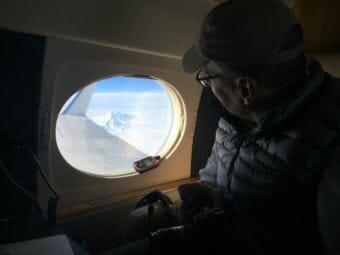
The National Aeronautics and Space Administration (NASA) is best known for its exploration of the world beyond our planet. But on a recent NASA science flight over Interior Alaska the plane never left earth’s orbit and the thing being studied was the ground. It’s part of project called the Arctic-Boreal Vulnerability Experiment (ABoVE) that NASA is leading to look at environmental changes in Alaska and northwest Canada, many of them driven by climate change.

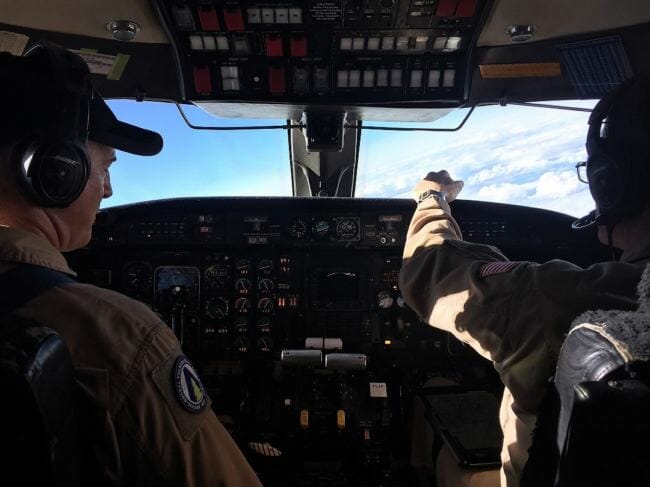
At Eielson Air Force Base, the spot where the plane takes off from, it’s spitting rain as the six-person NASA team files onto a small business jet.

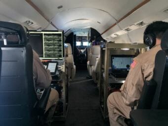
If you’d expect a NASA science plane to be all polished steel and shiny computer screens, you’d be wrong. There are some metal racks with monitoring equipment mounted on them, but this plane was built in 1983 and looks it: there’s old wood paneling and beige leather seats with brass seat belts.

“It’s a former air force plane… it used to fly generals around and NASA got it as a government surplus,” said Peter Griffith, an earth scientist with NASA. His colleagues refer to him with a chuckle as the “S.O.B” or “scientist on board.”

The flight has a 6-member crew, including radar operator Tim Miller (left), and Samuel Choi, mission director (right).  August 27th, 2018. (Ravenna Koenig/ Alaska’s Energy Desk)

So, what science is being done on board this airplane?

It has to do with a piece of equipment we can’t see from inside. A super fancy radar stuck to the bottom of the plane that jumps into action once we’re up at 41,000 feet.

“So the radar is now shooting off the left wing of the plane. It’s picking up the vegetation structure, it’s picking up the ground surface, and it’s picking up a little bit of information about how much soil moisture is in the top of the soil,” Griffith explained.

That information — whether there’s forest, shrub or tundra below us, whether the ground is rising or sinking, and what the soil moisture is — will help NASA answer a larger question.

“The information that we’re getting on this flight will help us understand on a much broader scale how permafrost thaw is occurring across this area,” Griffith said.

Permafrost isn’t the only thing that the ABoVE campaign is studying. There’s a whole host of environmental changes the project is examining, like the severity and frequency of forest fires, insect activity and wildlife migration.

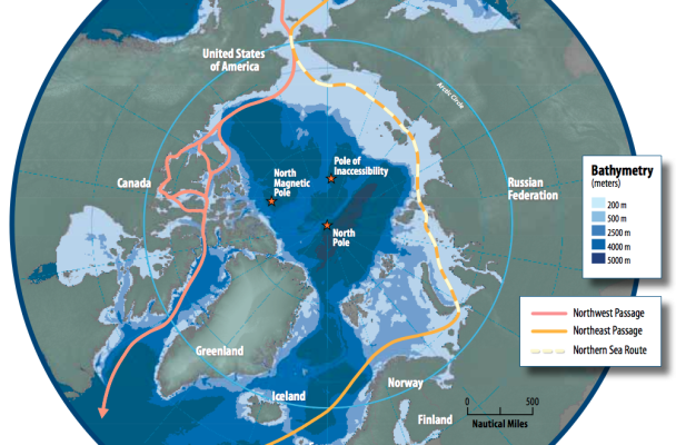
NASA’s big strength is collecting information from way above the earth, which lets them look at a huge area. The ABoVE domain is 2.5 million square miles.

But they’re also partnering with dozens of institutions to conduct research on the ground that ties into what they’re collecting from the air. The University of Alaska Fairbanks is one of their partners, as is the Alaska Department of Fish and Game, the National Park Service and the Department of Energy among many others. Griffith shows me a slide on his computer with the full list.

“When I put this slide together we had 379 U.S. science team members,” he said.

Peter Griffith, an earth scientist at NASA and project manager for the Arctic-Boreal Vulnerability Experiment, glances out the window at Denali. August 27th, 2018 (Ravenna Koenig/ Alaska’s Energy Desk).

That’s not counting additional collaborators in Canada.

At the end of this flight campaign, NASA and their partners will have a ton of data about how things are changing in a huge swath of the north.

But they’re not going to conduct these flights forever; they’re expensive. So another goal of the project is to refine some of the technology they’re using so it can be mounted on satellites.

That way, NASA can monitor these changes on a regular basis going forward.

Shipping titan Maersk sends company’s first container ship to test trans-Arctic trade route

A map of Arctic shipping routes, including the Northern Sea Route over Russia.
A map of Arctic shipping routes, including the Northern Sea Route over Russia. Maersk is about to test that route with a cargo ship for the first time. (Public Domain photo courtesy the Arctic Council)

The world’s largest container shipping company is about to send its first cargo vessel across the Arctic. It’s a small step, but a significant one in the expansion of trade in Arctic waters as ice recedes due to climate change.

The shipping company, Maersk, says the trip is a trial voyage. They’ve characterized it as an exploratory “one-off,” which will enable them to assess the feasibility of the route.

Ryan Uljua is a senior fellow at the Arctic Institute in Washington D.C. He says that the move is notable due to Maersk’s high profile, but it doesn’t signal an imminent wave of container shipping in the Arctic.

“I kind of think we’re more talking about a scale of decades rather than years before that is a regular occurrence,” Uljua said.

He added that the success of container shipping companies like Maersk depends on their reliability: getting goods to ports on time. And in the Arctic, weather and ice conditions are still too unpredictable for shipping companies to consider regular routes there.

But despite those difficulties, the Chinese-state owned shipping company COSCO — a competitor to Maersk — has been sending ships through the Arctic for several years. Uljua says that’s one factor driving Maersk.

“Their major strategic competitor is active in the Arctic so I think they’re feeling some pressure to explore it as well,” he said.

Maersk’s vessel is traveling the Northern Sea Route, starting in a Russian port near the border with China and moving up through the Bering Strait, along the Russian Arctic coast and into Europe.

New routes for the Bering Strait were approved earlier this year by the international organization that sets standards for marine safety.

The Maersk ship is expected to enter the Bering Strait around September 1st.

In Utqiaġvik, a growing erosion problem may soon outpace local efforts to slow it

A piece of the Utqiaġvik coastline in a residential area near downtown. Some of this bluff was eroded away during the September 2017 storm. Visible to the left are “supersacks,” part of the North Slope Borough’s current strategy for combating erosion. July 16th, 2018. (Ravenna Koenig/ Alaska’s Energy Desk)

Erosion is a widespread problem throughout Alaska, with at least 31 villages and towns facing imminent threats.

In Utqiaġvik, a lot of that erosion is connected with storm damage. As sea ice continues to trend toward coming in later and leaving earlier, it makes the coastline vulnerable to storms for more of the year. And as the erosion problem continues to get worse, the municipal government is facing tough questions about how to combat the issue going into the future.

A big North Slope Borough truck rumbles down the road that divides downtown Utqiaġvik from the Chukchi Sea. Scott Evans is behind the wheel; he works for the department that’s responsible for emergency management and disaster coordination within the North Slope Borough.

To our right is a sandy playground, and to our left the small sprawl of downtown: the Arctic Slope Regional Corporation headquarters, the courthouse, Wells Fargo bank and a few houses with sandbags stacked outside.

Evans points to the houses closest to us, and says that during a storm that hit Utqiaġvik last September, this area at the base of downtown was flooded.

“These lower houses right here, the lower-lying houses” he said, “the water certainly reached them.”

The cost of the damage from that storm to the North Slope Borough is still being figured out, but the rough estimate is $8 million. That reflects damage to roads and the structures that were supposed to protect the town from storm surge: a 600-foot seawall, sandbags and a 5-mile gravel berm that spans much of the coastline.

The borough is also worried about what might happen in the future to things like a critical water and sewer pump station, the drinking water lagoons and a decommissioned military landfill site located right by the beach.

A North Slope Borough sanitation facility in the distance, and behind the fence a decommissioned military landfill site. The Chukchi Sea is to the left. The borough is concerned about the threat that future flooding and erosion pose to the landfill. July 16th, 2018. (Ravenna Koenig/ Alaska’s Energy Desk).

Utqiaġvik is losing ground, and part of that has to do with these storms.

“If you’re here, and you watch a storm, and you watch the way we have to just continue to try to throw gravel at it and watch what it does to it, you realize that it’s a losing battle,” Evans said.

Right now, the borough’s main tool for combating the problem involves exactly that: throwing gravel at it. They’ve got a seawall made of wire mesh filled with gravel bags, huge “supersacks” full of gravel and a gravel berm they have to keep building up. The height varies, but even at 20 feet, it can be wiped out in a matter of hours if the right storm comes along.

“We know that the berm isn’t the long-term solution,” Evans said. “But that’s what we have the ability to do right now. So that’s what we’re continuing to do because we know it’s slowing everything down.”

When the damage from a single storm event goes beyond what the North Slope Borough can pay for on its own, it can seek help from the state and federal governments. That happened in 2015, and again with the storm last September.

But there’s a lot of damage from smaller events that the borough is on the hook for.

On top of that, they’re running out of material to hold back the ocean.

“Gravel here is almost akin to gold or silver: it’s that hard to find anymore,” said Bob Shears, who works for the North Slope Borough’s capital improvement department and is one of the people on the North Slope who’s thinking about how they’re going to address this problem in the longer term.

A gravel berm is one of the ways that the North Slope Borough has been trying to protect infrastructure from storm damage. But the borough says that as the erosion problem gets worse and gravel resources become more scarce, this solution is getting more tenuous. July 16th, 2018. (Ravenna Koenig/ Alaska’s Energy Desk).

He says that the U.S. Army Corps of Engineers will be releasing a study for public comment later this month, looking at engineering options that could protect the town for years into the future.

The corps is still deciding exactly what that would look like, but essentially the idea is to armor the coastline in front of Utqiaġvik with big 2.7-ton rocks, so that from the ocean it would look like a continuous rock wall.

A preliminary estimate for all that is $120 million. About one-third of that would be paid for by the North Slope Borough. The rest would have to come from Congress.

Shears says that’s nowhere close to a done deal.

“This game is not over ‘til it’s over,” he said. “We can lose just as easily as we can win.”

And even if they do get the money, Shears thinks it could be awhile. Which means they have to figure out something else in the meantime.

Back at the Utqiaġvik coastline, I ask Scott Evans if the borough is ready for the storm season that’s just around the corner.

“Would we like to be more prepared? Would we like to have other solutions out there that are more robust than we have right now? Of course,” he said.  “But the reality is… this is where we’re at right now.”

He says that they’re getting federal and state assistance to build things back to where they were before last year’s storm and make things a little stronger for the future. In addition to federal and state money, the North Slope Borough will also use its own funds to make improvements.

The rest, they’ll have to cross their fingers for and hope that the coming storms don’t outpace their ability to fend them off.

Alaskans may soon be able to finance energy improvements through their utility bills

In late July, Governor Walker signed HB 374 into law at the home of Karl Kassel, mayor of the Fairbanks North Star Borough. The new law will enable utilities to finance energy improvements for customers by adding line items to their utility bills. (Photo Courtesy of Representative Adam Wool’s office).

Utility companies will soon be able to loan customers money for energy efficiency upgrades and renewable energy systems by tacking on a charge to their monthly utility bill.

It’s a form of lending called “on-bill financing” that has been used elsewhere in the country, and was made possible in Alaska by a bill signed into law by Governor Walker last month.

The utility loans could cover a range of upgrades including solar panels, higher efficiency appliances and switches in heating fuel systems.

“We think it’s a good tool to have and we certainly will look at using it,” said Cory Borgeson, President and CEO of the Golden Valley Electric Association in Fairbanks.

Borgeson testified before the state legislature in favor of the bill. While he says Golden Valley doesn’t currently have plans to implement a loan program right away, they will consider it in the future.

“It kind of requires Golden Valley to set up a banking business,” he said. “We have to make loans, we have to charge interest rates, we have to process payments, what happens when someone doesn’t pay?”

The bill gives utility companies the power to suspend service to a customer if they fail to pay back their loan.

Representative Adam Wool, a democrat from Fairbanks, is one of the bill’s sponsors. He said in a press release that the new legislation is “vitally important for the Interior Energy Project.”

The goal of that project is to expand access to natural gas in the Interior. Wool said it could be used to help Fairbanks area homeowners convert from heating oil to natural gas, which will be a key component to the project’s success.

The Interior Gas Utility, which would provide that natural gas, says it is evaluating all options to help residents with conversion, including a possible loan program.

New data on Chukchi Sea polar bears leads to subsistence harvest level increase

A polar bear in Arctic Alaska. Subsistence harvest levels of Chukchi Sea polar bears have just been raised, based on new data about the population’s health. (Photo Credit: Terry Debruyne/U.S. Fish and Wildlife Service)

Native hunters in Alaska are about to see an increase in the number of polar bears they can harvest from the Chukchi Sea bear population.

The commission responsible for setting that limit recently raised the quota from 58 to 85 bears per year, shared equally between Alaska and Russian hunters.

The quota increase was based on new science and traditional ecological knowledge indicating that the polar bear population is doing well.

Eric Regehr is a polar bear biologist at the University of Washington’s Polar Science Center and one of the scientists who advised the commission.

“Currently the nutritional condition, or the fatness, of the bears in the Chukchi Sea is on par with what it was 20, 30 years ago,” Regehr said.

In 2010 the U.S. and Russia put a limit on the number of polar bears Native hunters were allowed to harvest from the Chukchi Sea population. It was part of an effort to conserve the animals in the face of uncertainty about how they would respond to sea ice loss.

Regehr says the new research indicates that the population numbers and reproductive rates of the Chukchi Sea polar bears are good, but that doesn’t mean there aren’t concerns for the future.

“Sea ice loss associated with climate change is the primary threat to the species,” Regehr said. “And we don’t know when or how it may affect Chukchi Sea polar bears, but we would expect, from a scientific perspective, that at some point in the future there will be some negative effects.”

Regehr says that in contrast to the Chukchi Sea bears, evidence suggests that Alaska’s other group of polar bears in the Southern Beaufort Sea is already experiencing negative impacts from the decline of sea ice, including weight loss and a reduction in both reproductive and survival rates.

On average, Alaska Native hunters take about 30 Chukchi Sea polar bears a year.

Katya Wassillie is executive director of the Alaska Nannut Co-Management Council, or ANCC, the group that represents Alaska Native polar bear hunters. She says that the good health of the Chukchi Sea bears is cause for celebration.

But while ANCC is pleased that the harvest number has increased, Wassillie says the group was advocating for an even larger quota.

“When you introduce something like a quota, that creates a different atmosphere, one with more anxiety, with competition,” said Wassillie. “And our hunters were concerned about that. So they wanted just a cushion; the freedom to be able to manage through our own traditional values, our own traditional practices.”

The commission that sets the harvest limit reviews the quota annually. A quota has been in place since 2010, but as of yet is not enforced.

Experiments in northern Alaska seek to improve projections for a changing Arctic


Plant physiologist Alistair Rogers standing by a warming chamber on the tundra close to Utqiaġvik. The experiment is part of a larger project run by the Department of Energy to collect data on natural processes in order to better predict how the Arctic will be affected by climate change. (Ravenna Koenig/ Alaska’s Energy Desk).

If you live in a place that’s particularly vulnerable to climate change, you want to know specifics about what that change is going to look like in the future: how high can you expect storm surges to be? How much is the permafrost going to thaw, and how fast? A Department of Energy project in Alaska is trying to get the Arctic closer to some of those answers.

On a spot of uneven tundra just a 15-minute drive from downtown Utqiaġvik, Alistair Rogers stands surveying his experimental domain: several short greenhouse-looking structures connected by a webbed plastic pathway.

Rogers is a plant physiologist at Brookhaven National Laboratory in New York. He’s part of a team of scientists with the U.S. Department of Energy who are working at four sites around Alaska.

Their project is called Next-Generation Ecosystem Experiments, or NGEE Arctic, and they’re looking at some of the natural processes that happen on land in northern Alaska — like microbial activity in the permafrost, the spread of shrubs across the tundra and, in Rogers’ case, how tundra plants interact with the atmosphere.

Inside one of the greenhouses, Rogers’ colleague Kim Ely bends over a small, boxy piece of equipment.

“What I have here is a machine that we’re measuring photosynthesis and respiration rates [with],” Ely explains. “And it’s currently clamped on a little leaf down here that’s within the measurement chamber.”

The humming machine has a name tag stuck on the top, partly so it doesn’t get mixed up with the other machines, and partly because Rogers is a bit of a sports fan.

“They’re all named after New York Yankee players,” Ely said. “So there’s Bernie, and Andy, and Jorge, and Derek, and Mariano.”

The photosynthesis measurement being taken by the “Bernie” box will eventually become… math.

“Photosynthesis for example,” said Rogers. “There’s a bunch of equations which describe how the holes on the leaves open up and let CO2 in and let water out.”

Those equations will be used to make projections about how the Arctic will be impacted by climate change.

While there’s been a good amount of data collected on that kind of thing in different parts of the world, like in the grasslands and temperate forests, in the Arctic there’s been hardly any.

“What we’re trying to do is make better predictions so that we can basically provide policy-makers with more useful, actionable information,” said Rogers.

Already, Rogers says that his team has gathered data that’s helped revise some previous assumptions about how Arctic vegetation works. They hope that the combined work of all the teams on the project will refine their understanding of what may happen in the Arctic of the future.

The data is publicly available; scientists working on climate projections — or any other research — can access it online.

Site notifications
Update notification options
Subscribe to notifications