Oceans

Fisherman’s photos could be first visual evidence of North Pacific right whales in the Bering Sea in winter

The blocky heads of two right whales poking out of the water
Two North Pacific right whales photographed near Unimak Pass on Feb. 8, 2022. (Photo courtesy of Josh Trosvig/FV Cerulean)

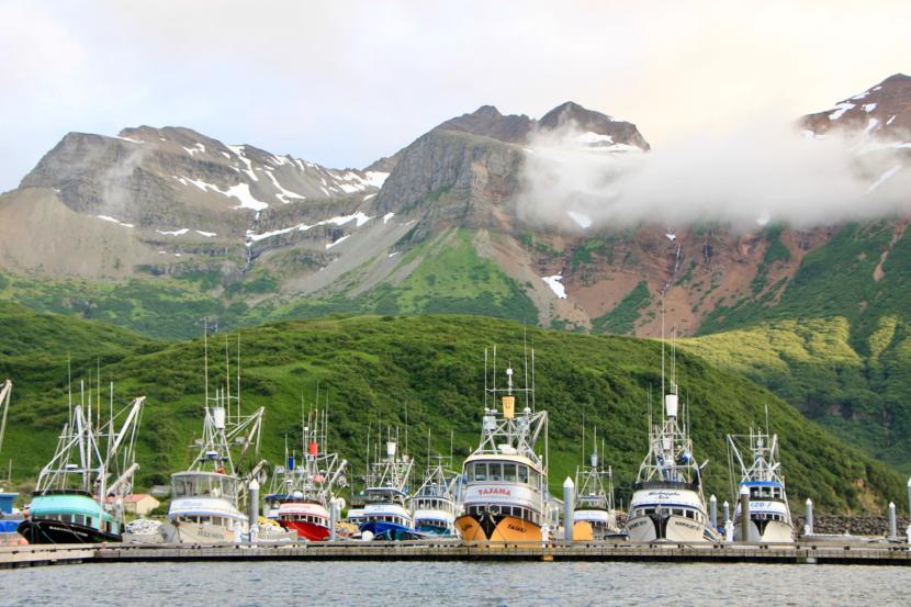
Josh Trosvig is the captain of the Cerulean, a 58-foot boat currently fishing for cod in the Bering Sea, about 80 miles northeast of Unalaska.

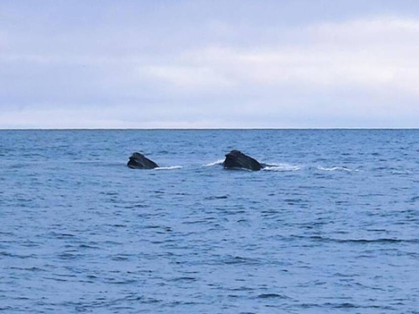
On a sunny day earlier this month, while he was waiting for the tide to change, he said he spotted something that looked like a large tote bobbing on the surface of the water, about 300 feet from his boat.

It turned out to be a group of whales.

But not just any whales.

“I’ve seen a lot of whales — thousands, tens of thousands in my 35 years of fishing out here,” Trosvig said. “But this was unique. I’ve never seen whales feed like that.”

Trosvig didn’t know it at the time, but the whales he was watching were North Pacific right whales. They’re critically endangered. And scientists say Trosvig is likely the first person to take photos and video of the whales feeding in the Bering Sea in the winter.

It took emailing between a few scientists until the whales were identified, because the sight is so unusual. Trosvig’s footage and other photos from fishermen prompted officials to call on fishing boats to exercise caution in the area.

Also, scientists say the images could help fill in some mysteries about the very small whale population.

“To my knowledge, this is the first sighting of North Pacific right whales in winter in the Bering Sea,” said NOAA Fisheries scientist Jessica Crance. “We have acoustic detections, or sound recordings, of whale calls during January, but no actual sightings from this time of year.”

Rolling along the water’s surface ‘like bulldozers

As Trosvig stood on his boat, looking out at the water, he said the whales moved almost “like bulldozers.”

They’d pop their heads up and roll along the water’s surface for minutes at a time — feeding behavior he’s never witnessed before.

At first, he said, he thought they might be bowhead whales feeding on marine invertebrates, based on their color and size. But he wasn’t sure. So he took out his phone and recorded them. Then he sent the video to an assistant area management biologist with the Alaska Department of Fish and Game in Unalaska/Dutch Harbor.

I firmly believe that knowledge is power, especially when it comes to the oceans,” Trosvig said. “We know more about the universe outside our solar system than we do about the depths of our own ocean. And for proper fisheries management and ecological management of the ocean, it’s critical for all of us to work together.”

Asia Beder manages groundfish fisheries in the Bering Sea-Aleutian Islands region. When she got the video from Trosvig last Tuesday, she dug through her marine mammal identification books, trying to identify the dark whales with white bumps on their heads and jawlines called callosities.

But she said she wasn’t completely sure what species they were. So she forwarded the video to NOAA fisheries for help.

“The simple email of, ‘Can you ID this?’ which I’ve seen many times for fish and crab and other animals, turned into a big thing,” said Beder.

The video of the whales then made its way to Crance, who helped solve the mystery. She’s a Seattle-based research biologist with the Marine Mammal lab at the Alaska Fisheries Science Center, part of NOAA Fisheries. She said she helped identify the whales in the video as North Pacific right whales.

Beder, in Unalaska, was shocked.

“I don’t know anything about right whales, to be honest,” she said. “I know they exist, and I knew the population was low. But I didn’t realize how low, and so these sightings are really important.”

Eastern stock whale population falls from thousands to about 30

Right whales are among the rarest of all marine mammal species and have never been documented in the Bering Sea in winter months. They’ve been listed as endangered under the Endangered Species Act since 1970 and are depleted under the Marine Mammal Protection Act.

There are three different types of right whales: the North Atlantic, the Southern and the North Pacific. And the North Pacific right whales are split into two stocks: the eatern and the western.

“The western right whale is over in Japanese and Russian waters,” Crance said. “They number somewhere in the low hundreds, maybe 300 to 500 animals. The eastern stock is critically endangered.”

Scientists estimate there are only about 30 animals left in the eastern stock. That’s because the large baleen whales became the target of whaling in the 1800s. According to NOAA, the right whale got its name because it was the right whale to hunt — it moved slowly and would float after being killed.

It’s estimated that anywhere between 25,000 and 35,000 animals were taken in just a few decades,” Crance said. “So that brought the population to maybe around the high hundreds of animals. But then in the 1960s, the Soviets began hunting right whales illegally and took over 700 additional whales. That decimated the population and brought it down to what we think are their current numbers of roughly 30 animals.”

Crance — who has been studying right whales for more than a decade — said the eastern stock feeds in the southeastern Bering Sea during the summer months. But because there are so few of them to track, it’s still unknown where they go the rest of the year.

Prior to this, we assumed that they all migrated south, much like every other large whale population,” said Crance.

Because of Trosvig’s video, researchers are now thinking some of the whales may stay in the Bering Sea through the winter.

Crance said that because they know so little about the eastern stock — including even how long they live — every single sighting increases their knowledge considerably.

That knowledge helps them continue to monitor and study the right whale population, she said.

Tracking whales by the white bumps on their heads

NOAA has a catalog of whales they’ve seen before, with corresponding numbers or names, Crance said. And they’re able to track specific whales based on their callosities.

But Trosvig’s video and photos are too far away to confirm if they’ve seen the whales before.

“There’s no way to know if these are known individuals or are new to us,” Crance said.

There are a few known right whales that have been spotted in the Bering Sea in the past. But they were observed in the spring and summer.

For instance, Phoenix, a juvenile right whale, was spotted in the Bering Sea in 2017 — the first juvenile to be seen there in more than a dozen years. He was viewed as a sign of hope that the population might recover, said Crance.

Notchy was named for the notch on its flukes, and is the first and only North Pacific right whale to have been matched to both a high and low latitude area, according to Crance. Notchy was photographed in April of 1996 in Hawaii and, four months later, in the Bering Sea in Alaska. Notchy has made at least one migration, according to Crance, and is the only documented migration they have for this population.

Crance said Tuesday that NOAA hasn’t received any new images of the whales spotted by Trosvig in the past week or so.

But NOAA Fisheries and the U.S. Coast Guard are urging boaters to be careful in the area of Unimak Pass so they don’t harm the whales if they’re still nearby. The area is a major transit zone for ships — not just in and out of Dutch Harbor, but also to the rest of the world.

“Because they’re so critically endangered, every animal is crucial to the health of this population,” said Crance.

Also, Crance said, she hopes fishermen will continue to document the whales when they see them and send photos and videos to Fish and Game or NOAA.

“Every sighting that we get helps put one more piece of the puzzle together to try and understand the migration and movement patterns of these animals,” she said.

Scientists use drones to count Chukchi Sea walruses without disturbing them

An aerial photo of many walruses hauled out on a beach
Thousands of Pacific walrus gather on shore near Point Lay in this aerial image captured during a NOAA survey of the Chukchi Sea. The arctic surveys serve to document the distribution and relative abundance of bowhead, gray, right, and fin whales, belugas, and other marine mammals in areas of potential oil and natural gas exploration, development, and production activities in the Alaskan Beaufort and northeastern Chukchi Seas. (Photo by Corey Accardo/NOAA)

Scientists from both the U.S. and Russia are using less invasive technology to get a more complete survey of the walrus population in the Bering Strait region. Their updated methods of surveying could lead to better management and protection of the subsistence marine mammal.

Tony Fischbach is a wildlife biologist with the U.S. Geological Survey Alaska Science Center. He’s been collaborating with scientists from the Russian side of the Bering Strait to test newer methods of surveying walrus on both sides of the Strait.

“With the help of Anatoly Kochnev and a team of biologists working there (in Chukotka), they were able to monitor five different sites using drones, and they also did controlled experiments in places where there weren’t too many walruses to determine what altitude the walruses will tolerate,” Fishbach stated.

The partnership helped scientists determine that if they flew a drone less than 50 meters above the head of a walrus, the walrus would be disturbed and flee, Fischbach said during a Strait Science presentation hosted by the University of Alaska Fairbanks Northwest Campus in Nome. But if the drone was flown higher than that height, then they would be able to safely conduct their surveys.

Fishbach says his team now flies drones about 100 meters above walruses, to be doubly sure they don’t disturb them. Overall, he thinks relying on drones rather than aerial surveys in small planes flown by private pilots is the better option.

“It’s much, much safer, not only for humans, but much safer for walruses. The best thing for us, is you can get more data. Whenever the weather breaks, the rain stops, and lays down, we can get out of our tents, launch this thing, get the survey done, and do it safely,” Fischbach said. “And the data is better too.”

Fischbach’s research team was able to fly 26 drone surveys in a span of two years to count walruses. That’s compared to the old method of flying planes for aerial surveys a few times a year, which was limited by costs, weather, and seasonal challenges.

Thanks to drone surveys, they were able to release “defensible numbers” from their annual walrus count at a previous Point Lay haul out, Fischbach said. The team estimated almost 60,000 walruses were on the beach during surveys taken at Point Lay in the fall of 2018 and 2019.

Once Fischbach and his team combine the survey data with information gathered from radio telemetry tags they placed on a number of walruses, then he says they will have a fuller picture of the regional population.

“And now that we have this methodology worked out, we can collaborate with partners in Northern Chukotka,” Fischbach said. “If they are interested, we can build a team, and we can do an estimate for the entire Chukchi Sea during that open water period.”

Anatoly Kochnev is one of the scientists who has been doing similar drone surveys on the Chukotka side of the Strait since 2017 and studying walruses for decades. Kochnev has also conducted aerial surveys of walrus, as well as focused on the local polar bear population in Chukotka for 30 to 35 years.

“The Pacific walrus is our shared resource, and Russia and the US need to work together to effectively manage and conserve the population,” Kochnev told KNOM via email. “Therefore, I really hope for continued cooperation. I think we need to focus on developing a simple and reliable method for regularly estimating population size – for example, using satellites is exactly what Tony [Fischbach] is doing right now. I would also like to continue monitoring the land walrus haulouts. In addition, we need to focus on tracking changes in the population associated with climate change.”

Kochnev’s and other Russian scientists’ involvement hinges on the 1994 re-negotiation of the U.S.-Russia Environmental Agreement to cooperate on environmental issues of mutual interest and concern.

As scientists from both sides of the Strait gather better survey data of walruses, this data could be used to inform management practices for U.S. and Russian agencies and to protect the animals from increasing vessel traffic.

Fischbach pointed to numerous ships transiting up and down the Chukotka side of the Bering Strait, mostly going in and out of the Sea of Okhotsk.

“The main thing is that we’re able to provide near-real-time management information and let people know ‘oh, take that different approach,’ so don’t fly over them [the walrus] for the aviators. And the same thing for mariners. That can be provided to authorities and they can give advice to people. It can also be used to support haul-out based estimates we were working on before,” Fischbach explained.

One of the next goals for Fischbach and his research team is to do future population estimates of walrus using satellite imagery counting the animals directly from space.

The U.S. Fish and Wildlife Service does not yet know when they will do an updated survey of the Chukchi Sea walrus population, according to Fischbach.

Mercury levels in Stellar sea lion pups are rising. Researchers look to the past to find out why

Two women looking at plastic bags laid out on a table
Nicole Misarti (left) and Caroline Funk traveled to Unalaska in the summer of 2021 to collect bone fragments from Steller sea lions, northern fur seals and Pacific cod. They scanned the bones for mercury levels to answer whether spikes in certain areas of the Aleutian Islands were caused by human activity. (Photo by Theo Greenly/KUCB)

Researchers looking into the decline of Steller sea lions over the last decade noticed that the concentration of mercury levels in lion pups was increasing in some parts of the Aleutian Islands — but they didn’t know why.

Now, a group of scientists from around the nation are working to solve that mystery with a research project called Aleutian Mercury Dynamics.

The project’s goal is to create a timeline to see mercury levels in the Aleutian Islands over the last few thousand years.

“We are looking at how mercury is present in the marine food web over thousands of years, to better understand implications for today,” said Caroline Funk, an archeologist from the University of Buffalo in New York.

Funk traveled to Unalaska in the summer of 2021 with another scientist from the project, Nicole Misarti from the University of Alaska Fairbanks. Together, they collected tiny fragments of bone from Steller sea lions, northern fur seals and Pacific cod to bring to Fairbanks and scan for mercury.

A shelf covered with ziploc bags filled with bone fragments
Animal remains from midden sites across the Aleutian chain reveal mercury levels as far back as 4,000 years ago. (Photo by Theo Greenly/KUCB)

The Museum of the Aleutians in Unalaska has the remains from midden sites — mounds of refuse from ancient villages — across the region, some dating back more than 4,000 years.

The bone fragments come from Unangax̂ villages across the Aleutian chain. This can be a culturally sensitive topic, so the researchers are working closely with the museum, as well as Unangax̂ tribes and corporations across the region.

Mercury can spike for natural reasons. Two prime causes are volcanic eruptions and the melting Arctic. When a volcano erupts, it releases mercury into the atmosphere. Additionally, permafrost stores mercury, so the element is released as the permafrost thaws.

But human activity can also release mercury into the atmosphere. Industrial activities, like burning fuel, release mercury as well.

The mercury research project aims to see if there were spikes in mercury across the region in pre-industrial times. That would help answer the question of whether this is solely a human-caused problem, or if it predates human activity.

“Is it coming from factories down south or in Asia that’s being blown over and dropping here?” Misarti said. “If we look 4,000 years in the past, and we have times…when there are spikes in mercury that are as much or bigger than the mercury we’re finding now, then we know this isn’t completely a human problem.”

A pair of gloved hands beginning to saw into a bone fragment with a dremel tool
Nicole Misarti from Aleutian Mercury Dynamics saws off a small fragment of marine mammal bone to bring to her lab at the University of Alaska Fairbanks. (Photo by Theo Greenly/KUCB)

Bones can be a window to the past. They can tell you what an animal was eating and where it was eating it. Misarti said they can extract reproductive hormones, stress hormones, and ancient DNA. And they can tell how much mercury was in the environment when the animal was alive.

After collecting tiny bits of bone fragments — about two grams of each animal — Funk and Misarti traveled to their lab in Fairbanks, where the team began analyzing the bones for mercury.

“It appears that we do have some changes through time over the last 4,000 years,” Misarti said. “From there, we’re looking at what those patterns might mean.”

They don’t have a lot of the answers they’re hoping to find yet. This is the beginning of a long, complicated process, and researchers expect to go through hundreds of samples over the next few years.

Impacts of warming temperatures dominate discussion of Arctic Report Card

Scattered sea ice near Nome, Alaska, March 15, 2019. (Photo courtesy David Dodman via KNOM)

Warm temperatures, melting sea ice, ocean debris and permafrost degradation dominated discussion of the 2021 Arctic Report Card by the National Oceanic and Atmospheric Administration.

NOAA Administrator Rick Spinrad summed up the overall feeling of disquiet.

“The trends are consistent, alarming and undeniable. Rapid and pronounced warming continues to drive the evolution of the Arctic environment. From this year’s report card, we learn that the October to December 2020 period was the warmest Arctic autumn on record dating back to 1900. The average surface air temperature over the Arctic this past year was the seventh warmest on record,” Spinrad said.

Deputy Lead Scientist Twila Moon of the National Snow and Ice Data Center addressed the issue of the Arctic’s rising temperatures specifically, saying the Arctic is warming at more than twice the rate than the rest of the globe.

This means that the flora, fauna and peoples of the Arctic continue to experience rapid and often dramatic changes,” Moon said.

Moon stressed, however, that it is important not to oversimplify the Arctic ecosystem as one continually warming event. She pointed out that data can vary from location to location, and from season to season, painting a far more complex picture of the Arctic.

Lawrence Mudryk, who is a scientist from Environment & Climate Change Canada, had a presentation that touched on melting sea ice. Ice coverage of the Arctic seas has declined greatly over the past few years, according to the report card findings. Notwithstanding a few ups and downs in sea ice extent in the past few years, Mudryk noted that scientists have observed the fifteen lowest extents of sea ice all within the last fifteen years.

Mudryk pointed out that diminishing sea ice contributes to warming Arctic temperatures, not to mention negatively impacts Indigenous peoples who have depended on sea ice for their way of life for centuries.

“Sea ice’s high reflectivity plays an important role in regulating the amount of sunlight that enters the Arctic region and thereby helps to regulate its temperature. As sea ice disappears, the underlying ocean surface is exposed, and this much darker ocean surface will absorb sunlight and thereby allow a lot more heat to enter the Arctic system,” Mudryk said.

Gabriel Wolken, a research professor at the University of Alaska Fairbanks, presented on the state of the Arctic’s permafrost.  He dwelt on the degradation of some of the Arctic’s once stable permafrost and the implications these changes have for the plants, animals, peoples and structures housed in a permafrost environment. A greater familiarity with the conditions and locations of permafrost degradation will help scientists identify trends, Wolken said. A sounder understanding translates to a stronger ability to help affected communities navigate the hazards of warming permafrost.

The last presenter, Kaare Sikuaq Erickson of Unalakleet with Ikaagun Engagement, ended on a positive statement. Alluding to how he witnessed his people come together and call upon their traditional values of sharing and cooperation during the ongoing hardships of the pandemic — when access to outside food was limited. He called for cooperation in the Arctic.

“I think people need to put their differences aside and work together on things. The polarization of our society is not helping anything. In the Arctic, we really do have to put things aside and focus on practical solutions. Otherwise, we won’t survive. I think the rest of the world is going to have to face that as well,” Erickson said.

He pointed out that cooperation has been one of the great strengths of Alaska Natives.

“We really did fall back on that kind of communal sharing, relations with others in our villages … because these are lifelong dependencies on our neighbors,” Erickson said.

The 2022 Arctic Report Card will be released at the end of the year.

Navy seeks expanded area for Northern Edge drills in 2023

Crew members handling fighter jets as they take off and land onboard the USS Theodore Roosevelt during exercises in the Gulf of Alaska during Northern Edge 2019 (Photo by Zachariah Hughes/Alaska Public Media)

The U.S. Navy says its warships will need more room to maneuver during next year’s military exercises in the Gulf of Alaska. It’s going through the permitting process and accepting public comment on the proposal next month.

The Navy conducts live-fire exercises in federal waters east of Kodiak Island and south of Prince William Sound as part of the military’s Northern Edge training exercises.

John Mosher, a civilian environmental planner for the U.S. Navy, says military leadership has decided the current 55,000-square-mile area is too tight for maneuvers by its half-dozen warships

“The area that we were kind of restricted to operate in was just too limited,” he told CoastAlaska on Tuesday. “It wasn’t a realistic way of maneuvering our vessels and our aircraft as they would in a real world scenario.”

The Navy is proposing to add a 246,000-square-mile zone that would extend westward as far as Dutch Harbor in the Aleutians. It would be used for transiting and not for live-fire drills or active sonar usage, both of which would only be conducted in the existing area.

The drills have been criticized in the past by some who object to its scale, timing and location due to its proximity to fishing grounds and sensitive habitat.

But Mosher says past exercises haven’t created any problems for fishing boats or civilian shipping in the area.

Our vessels typically operate further away from the main channels, the main fishing grounds, things like that,” he said.

A map showing Southwest Alaska and the Gulf of Alaska
The Western Maneuver Area is the expanded area proposed by the U.S. Navy for 2023. The military says live-fire drills and active sonar would remain limited to the existing “Temporary Maritime Activities Area” that it’s used in the past. (Image courtesy U.S. Navy)

The Navy also says it won’t detonate explosives in waters that are less than 4,000 meters (13,120 ft.) deep. Mosher says that pledge is in response to comments from Alaska Native tribes and the commercial fishing industry.

It eliminates the potential for effects on fish, on marine mammals, on marine birds and then also minimizes the potential to overlap with fishing activities,” he said.

Northern Edge is a biennial training exercise conducted in and around Alaska. It’s headed-up by the Air Force and involves service members from every branch of the military. It was last held in June 2021 and included an aircraft carrier.

The precise dates of the 2023 exercises haven’t been announced. In the past, military vessels have broadcast on automatic identification systems transponders. Mosher says whether that would happen next year is up to military planners.

A 45-day comment period will collect comments on the Navy’s proposal to expand its area of maneuvers during 2023’s Northern Edge exercises.

The Navy announced Tuesday on its Gulf of Alaska website that it’s seeking to amend its existing environmental impact statement for the proposal. A formal decision is expected in the fall, the Navy says.

Chris Woodley of the Groundfish Forum, which represents trawlers in the Gulf of Alaska, said several commercial fishing groups are just now reviewing the Navy’s plans and didn’t have any immediate comment.

Aid from fisheries disasters can take years to come through

Fishing boats wait for an opener in Chignik’s city harbor in 2019. The 2020 Chignik salmon fishery was one of 14 Alaska fisheries disasters recently declared by the federal government. (Photo by Alex Hager/KDLG)

Earlier this month, the U.S. Secretary of Commerce declared disasters for over a dozen fisheries in Alaska — more than the federal government usually approves at once.

The designation is supposed to unlock funds to help the communities impacted by those fisheries failures, including communities around Cook Inlet. But it can take years for the money to reach fishermen’s pockets.

U.S. Sen. Lisa Murkowski said the timing is one of the problems with the process.

“If you’ve had a disaster that happened in 2018, we’re sitting here in 2022 and you’re saying, ‘Really? You think that that’s going to help me?’ In the meantime. I’ve got a boat mortgage that I’ve got to be paying. I’ve got a crew that I’ve got to be paying. This doesn’t help me at all,” she said.

The state knows the process can be lengthy and tries to expedite it where possible, said Rachel Baker, Alaska’s deputy Fish and Game commissioner.

It starts with requests from the impacted communities. The Kenai Peninsula Borough Assembly made its request for a declaration for the 2020 season just over a year ago.

The state fields the requests first, then checks to make sure the fisheries meet certain federal criteria — like negative impacts to a significant share of the fleet, or that the disaster could not have been prevented by fishery managers.

“We do that initial evaluation,” Baker said. “So that’s why sometimes it can take just a little bit of time between the time we receive the request from affected fishery participants and the time the request formally goes from the governor to the Secretary of Commerce.”

The state makes a list of the fisheries requesting relief and sends that letter to the federal government. Then the U.S. the Secretary of Commerce makes a decision. Secretary Gina Raimondo released her list of 14 Alaska fisheries earlier this month.

This year’s list is unusually long, Baker said.

Two fishery disasters were declared in Alaska in 2018, for sockeye and Pacific cod, and one in 2016 for pink salmon. Before that, the most recent one was in 2012, for king salmon in the Cook Inlet and the Yukon regions.

“It seems to be increasing in frequency that we’re having disaster conditions in fisheries,” Baker said.

She said COVID-19 did impact fisheries in 2020. But for the most part, revenue losses didn’t stem from reduced effort from Alaska’s fleets.

“It was definitely issues related to fish returns,” Baker said.

The 2020 Pacific cod fishery is one of the failed fisheries on the list. A heat wave that hit the Gulf of Alaska decimated cod stocks there, prompting federal managers to close the fishery completely in 2020.

Several salmon fisheries in the Yukon-Kuskokwim area are also listed. Advocates there told KYUK they hope some of the federal funding they receive can be used to determine why salmon are declining so severely in the region.

The 2018 Cook Inlet east side setnet fishery is a recipient, too, as are the 2020 Upper Cook Inlet salmon fisheries. The harvest in Cook Inlet in 2020 was the lowest since 1971, with low salmon prices adding insult to injury.

But Cook Inlet fishermen and their communities won’t see the money right after a request is approved.

“And this is where we really do try to manage expectations related to these disaster programs,” Baker said. “It’s challenging, because obviously the participants in these fisheries were quite negatively impacted by these conditions.”

The disaster determination announcements only make fisheries eligible for disaster funding if Congress decides to set aside money. Baker said she’s not aware of any Congressional funds appropriated at this time.

Once Congress does appropriate funds, the state works with fisheries participants to develop a distribution plan. Then the plan goes back to the federal government.

“Which unfortunately, in some cases, can take quite some time,” Baker said. “And then after that process, the application process can begin for eligible participants and the funds can be distributed.”

In 2012, when the federal government declared a king salmon fishery disaster, Alaska was eligible for $21 million, some of which made its way to Cook Inlet stakeholders. It’s unclear now how much money Cook Inlet communities might receive this time around.

Baker said the state is gaining experience with handling these disaster declarations as it racks up more and more. She said it will try to quickly move the process along when possible.

Murkowski said she’s working on federal legislation to make the fishery disaster declaration process more transparent going forward.

Site notifications
Update notification options
Subscribe to notifications