Science & Tech

Iconic Fairbanks satellite dish helps map floods thousands of miles away

Two research buildings on a hill. The one on the right is older and has a large satellite dish on its roof, pointed up.
The Elvey Building (right) on the University of Alaska Fairbanks campus is home to the Geophysical Institute and Alaska Satellite Facility. The Akasofu Building (left), houses the International Arctic Research Center. (McKade Sorensen/Alaska Satellite Facility)

A German American scientist has flown from Fairbanks to present at a conference in Chicago about satellite research of the Himalayas, as well as Central and South America.

If that all sounds rather global, well, that’s exactly the kind of collaborative and far-reaching work happening at NASA’s Alaska Satellite Facility, based at the University of Alaska Fairbanks’s Geophysical Institute.

Franz Meyer is a professor of remote sensing at UAF and the Satellite Facility’s chief scientist. Like many other researchers, he’s at the American Geophysical Union’s annual conference this week.

As Meyer explains, the work he’ll present is about the benefits of using satellites to map what’s happening on the ground in flood-prone areas, even if they’re covered by trees or clouds.

Listen:

The following transcript has been lightly edited for clarity.

Franz Meyer: It has these capabilities to penetrate through clouds and observe during day and night. So the communities in, say, Central, South America and Hindu Kush Himalaya, they are very interested in using these datasets and using them mostly for disaster management, food security and ecosystem stability monitoring. So, you know, there’s a local interest, of course, for local food security. These events affect the availability of food resources in the area, and also livelihoods. You know, how many people and what population is affected, etc. But on a global scale, one of our other partners in these projects, for instance, is the U.S. Department of Agriculture, and specifically the Foreign Agricultural Service. They need to know impacts of weather events on agriculture to understand things like food availability, market prices for different crops, etc., for these bigger events, like the monsoon rains in the Hindu Kush Himalaya. It has global implications on prices and availability of certain resources.

Casey Grove: Tell me about why that particular type of satellite is valuable for the work that you’re doing.

Franz Meyer: So radar remote sensing is useful because at microwave wavelength, signals can penetrate through the atmosphere, even during cloudy conditions. The 24/7 capabilities is great for Earth observation. So we put these radar systems on satellites and let them image and look at the surface. And we can use repeated observations to look for changes of the earth environment, both changes of the structure such as deforestation, agriculture growth, urban sprawl, etc. But we can also look very closely at surface displacement. If you think of, you know, volcanic eruption, or active volcanoes, or earthquakes or permafrost domes, the ground in these areas is going up and down and moving with the geophysical activity. And radar is just really good at measuring distances. And so by looking at and tracking distances over time, we can measure millimeter to centimeter scale surface displacements that relate to a lot of natural hazards and to a lot of the geophysical phenomena that we have here in Alaska.

Casey Grove: Gotcha, yeah. So now I’m going to ask you, why is someone based in Fairbanks doing this kind of work? And, I mean, maybe that gets to the technology and how the satellites work, and why the Alaska Satellite Facility is where it is. But why you? Why Fairbanks?

Franz Meyer: Part of this is because of the Alaska Satellite Facility. ASF was created originally as what’s called a ground station. So we operate a number of NASA-owned communication antennas to communicate with Earth observation satellites. And because these satellites are passing usually over the pole, the further north you are in latitudes, the more often you can see these satellites. So putting a ground station at high latitudes makes sense, because you have more contact, and you can download more data and an uplink more commands to the satellites than in lower latitudes. And so Fairbanks was picked at the time in the 1990s because it was the northernmost U.S. city that had stable power.

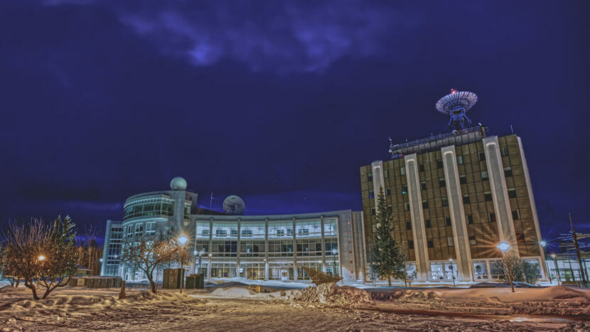
Casey Grove: Franz, I wanted to ask you just about the the blue dish on top of the Geophysical Institute. I know that the Satellite Facility uses other dishes, and that’s not the only one. But that’s kind of an iconic thing at this point, right? When you look up at West Ridge at the University of Alaska Fairbanks and you see that, it’s just part of that skyline, right?

Franz Meyer: Yeah, Casey, that’s a very good point. So, you know, a lot of people in Fairbanks and maybe in Alaska recognize the blue dish on the university campus on top of the GI building. It was put on the roof in the 1990s. We, overall, we operate currently four dishes, but this is the one that’s known to most people. It was actually replaced a few years ago, upgraded to have more broadband capabilities and be able to download more datasets. And one of the funny things we got from from the community here in Fairbanks is to make sure that the dish is blue again. It, sort of, was so iconic, that people didn’t want that to change. So that was one of the main input we got from Fairbanks itself was to make sure that the new dish that we put up there is blue. And of course it is again.

Casey Grove: Why was it blue to begin with?

Franz Meyer: So I was not around at the time, but my understanding is that it was to have it blend in more with with the sky and be a little bit less visible. You know, people didn’t initially like the idea of having this dish on the building. And so that helped, a little bit, alleviate people’s concern. But I think now it’s just an established part of the skyline here in in Fairbanks.

Casey Grove: Yeah. Well, so, we’ve talked a little bit about the past for the Alaska Satellite Facility, and then what you’ve been working on here, you know, currently that you’re gonna go present at the AGU conference. What’s the future for ASF? What, you know, I guess in the near term, what are you looking forward to?

Franz Meyer: Yeah, so, ASF, actually already over the last few years, we have been preparing ourselves for a very large upcoming mission that is being launched by NASA. There is a mission that’s called NISAR. So that mission is a collaboration between NASA and India. And it’s going to be launched in 2024. And it’s going to provide unprecedented data for monitoring dynamic signals on the planet. It’s going to provide unprecedented data volumes. The mission will provide about 50 petabytes of data per year. And so over three years, to give you sort of a scaler, this mission alone will provide more data than NASA currently holds in all of our archives combined. And we at ASF are the ones that will hold all these datasets. We’re also a downlink station for NISAR, so we’ll bring some data directly down through the dishes in Fairbanks into our archives.

More likely mud than magma, Sitka’s newest volcano is rising from the depths

A photo of a screen showing an image shaped like a volcano
Jacyn Schmidt and her fishing partner captured this image of a mud volcano on their depth sounder, just a few miles north of Sitka. (Photo by Jacyn Schmidt)

A couple of Sitka residents who were fishing for halibut last month noticed an unusual feature on their depth sounder as they set gear a few miles north of town. Two-hundred feet below the surface of the water, the sounder slowly painted a picture of what appeared to be a volcano: A perfectly formed cone about 100 feet tall, with a plume of gas trailing from the top.

Experts who’ve seen the image say it is no cause for alarm. It’s most likely a mud volcano, and it’s not the only one near Sitka.

Locals don’t use rods and reels much to fish for halibut in Sitka. Most set a subsistence skate — a long line baited with a dozen or more hooks that is laid right along the bottom from a slow-moving boat.

Jacyn Schmidt was doing just this in November near the entrance to Nakwasina Sound, 5 miles north of Sitka. Schmidt was on deck, paying out the line.

“My friend who I was out fishing with was inside watching the depths on the sonar, and he noticed just a weird shape, and called me in to look at it with him,” she said. “I think we both immediately saw that cone shape and the kind of trail coming out of it, thinking that it could be an underwater volcano of a sort.”

Had it been anyone else, this might have been an invitation to head for the hills. But Schmidt is the regional geoscience specialist for the Tlingit and Haida Central Council. She’d been in Sitka for what has been an interesting year for the region, geologically.

Her first impulse was to try and find the feature again, and then get on the phone.

“I’m aware of the geologic context of Sitka and the surrounding islands,” said Schmidt, “and spatially where the Queen Charlotte Fault is and where the Mt. Edgecumbe Volcanic Field is, and this location was just not adding up with the story that I know about our geology here. And so I just called the people who I knew had spent a lot of time thinking about the seafloor here.”

“It’s a classic example of what we have seen out on the fault, down around Dixon entrance,” said Gary Greene, one of the people Schmidt called.

Greene is a marine geologist, emeritus professor at the Moss Landing Marine Labs, and a leading expert on the undersea geology of the Queen Charlotte Fault.

“These types of plumes that come out of this volcanic-like cone are associated with what what we call mud volcanoes,” said Greene. “They’re not really active volcanoes, where magma comes flowing out, but it’s mainly fluids that come up from depth and carry with it sulfide-rich gasses and what have you.”

Greene has done sonar studies of the Queen Charlotte Fault that have produced images that are surprisingly similar to what Schmidt and her fishing partner saw on their depth sounder. The term “mud volcano” could conjure up thoughts of destruction, but — with a few exceptions — their only similarity to terrestrial volcanoes is their shape.

“If there’s a better term, I’d love to use it,” said Cheryl Cameron, “And right now, I don’t know about one.”

Cameron is a state geologist at the Alaska Volcano Observatory, and another expert Jacyn Schmidt consulted. Cameron is from Sitka and is familiar with the depth sounders people use here while fishing. She hesitates to draw any conclusions from the image Schmidt captured but admits that there are plenty of possibilities.

“A fishfinder is looking for reflections within the water column,” she said. “And so anything that has a density different from that of the rest of the water will cause a reflection. And so that reflector could be indicating a change in temperature or composition, it could be any kind of gas leaking out of the ground that would generate a plume with a different impedance, and thus a reflection. So it could be CO2 (carbon dioxide), it could be methane, it could be fluid with particulates in it —  there are a lot of possible causes that are not related to volcanism.”

Nakwasina, where Schmidt was fishing, is not within the Mt. Edgecumbe Volcanic Field — but it’s nearby. Edgecumbe generated headlines last spring when an earthquake swarm signaled that magma was stirring beneath the long-dormant crater. Subsequent radar studies showed that the flanks of the mountain had inflated by several inches over the last couple of years.

Greene says there’s not enough information to rule out that it might be related to what’s happening beneath Mt. Edgecumbe.

“It could very well be associated with that magma that’s moving up into the cone,” said Greene. “It could be that the heat from that magma has started a convection of warm or hot waters that are now venting at that locality.”

Jacyn Schmidt didn’t catch any halibut on the cone, but that unhappy fact hasn’t kept her away. Now, she’s fishing for information.

“Well, we keep going back again,” she said. “My friend, whose boat I was on, has gone back to the same place to check again and again, and it’s still a bump under the water. I still have so many questions, and would like to go back with better instrumentation where you could really see. But I’ll leave that to Gary and to Cheryl to direct.”

Although Schmidt is a scientist by profession, accidentally discovering an underwater mud volcano is a form of citizen science that is very useful to researchers. Cheryl Cameron welcomes any and all observations of geologic phenomena at the Alaska Volcano Observatory. Gary Greene is going a step further and looking for research funding to go down and take a look at the possible mud volcano, or at least take its temperature.

Another Aleutian volcano is showing signs of unrest

A snowy volcano, partly obscured by clouds, seen from across calm seas.
The east flank of Takawangha on June 10, 2021. (Loewen, M. /Alaska Volcano Observatory/U.S. Geological Survey)

Four Aleutian volcanoes have been under elevated alert levels for about a year. Now they’ve been joined by a fifth.

The new one is Takawangha, which rises 4,753 feet out of the Bering Sea in the far western Aleutians.

The Alaska Volcano Observatory put Takawangha on its watch list when a swarm of earthquakes with magnitudes between two and three intensified around the volcano.

John Lyons, a research geophysicist at AVO, said swarms often point to volcanic activity.

“That typically indicates that there’s been magma or volcanic fluid there,” Lyons said. “A swarm of earthquakes can often precede activity at the surface, including an eruption.”

The swarm began on Nov. 18, prompting the Alaska Volcano Observatory to move the volcano’s aviation color code to yellow, which means it’s showing elevated levels of activity but not erupting.

Active lava fountaining at Great Sitkin volcano on Aug. 5, 2021. (courtesy of Peggy Kruse)

The other four volcanoes are Great Sitkin, Cleveland, Pavlof and Semisopochnoi. Most have been moving in and out of the yellow and orange advisory levels. “Orange” means that an eruption is likely or already happening, but it’s not creating major hazards.

Five volcanoes rumbling at the same time might sound like a lot, but Lyons said it’s not uncommon for the state.

“There’s so many active volcanoes in Alaska, having five that have an elevated color code isn’t really extraordinary,” Lyons said.

Takawangha is about 55 miles west of Adak and could threaten the city of around 200 people should it erupt, but Lyons said the current advisory level is no cause for concern.

“The potential hazard to people in Adak is very low right now. And because the volcano is so well monitored, and because the Alaska Volcano Observatory is keeping an eye on it, there will be signs and we will catch those signs and put out timely notices if there’s any change in activity,” he said.

As of Monday, the swarm was still continuing at Takawangha and the color code remained at yellow.

Collaborative Indigenous Research is a way to repair the legacy of harmful research practices

""
Eve Tuck and Tkaronto CIRCLE Lab youth researchers and collaborators hold a hand-made banner that reads: ‘History erased but never displaced. WE ARE HERE.’ (Photo courtesy of Eve Tuck)

A recent disclosure from Harvard’s Peabody Museum has brought attention, yet again, to the need to rethink the relationships between universities and Indigenous communities.

Recently, the Peabody Museum announced that it has been holding locks of hair collected throughout the 1930s from more than 700 Indigenous children forced into residential boarding schools in the U.S.

The museum has apologized, vowing to return the hair clippings to Indigenous communities. In their written statement, they acknowledge that the clippings were taken at a time in which it was common practice in anthropology to use hair samples to “justify racial hierarchies and categories.”

If you grew up outside of Indigenous communities, Black communities, poor communities, and/or disabled communities, you might be surprised to learn that many have had negative experiences with university-based researchers. Nearly 25 years ago, renowned Maori scholar Linda Tuhiwai Smith observed that research is “probably one of the dirtiest words in the Indigenous world’s vocabulary.”

Some of the studies that have done Indigenous communities the most harm were used to justify genocide and land dispossession. These weren’t research as we would understand it today — they were white supremacist propaganda. But they are still the legacy of many contemporary fields of science and social science.

Some of these studies amounted to forms of torture deployed on Indigenous people, alongside Black people, people in concentration camps, disabled people and poor people under the auspices of science. These are the sorts of studies that necessitated the introduction of institutional ethics review boards in universities and communities.

Legacy of harmful research

Some studies have been coercive, not allowing Indigenous communities the ability to refuse or withdraw. Others have been conducted under duress. Some are deceptive. These are studies that say they are about one thing, but are really about something else.

Many other studies are extractive. Researchers pop up for a time, take what they need and leave. Far more are harmful because they over-promise (they can’t possibly generate the change that Indigenous communities desire). Or they are simply time-wasters: they learn something that the community already knew, but no one seemed to listen to them about.

Because of this history and contemporary situation, many people who grow up in Indigenous families are critical of researchers who don’t appreciate the real stakes, or real benefits, of research for Indigenous communities.

Learning from Indigenous ways of knowing

Since time immemorial, Indigenous communities have engaged in research activities, even when these approaches to research have been dismissed as unsystematic or not objective. Indigenous Peoples have always been researchers. Indeed, so many Indigenous worldviews, knowledge systems and values are based in inquiry, curiosity and sharing the results of inquiry through storytelling.

In addition to these ways of knowing, for more than two decades another approach to research with Indigenous communities has been practiced by researchers working inside and outside of the university. This approach, what I and others have come to call Collaborative Indigenous Research, is a deliberate challenge to the harmful ways university-based researchers have engaged with Indigenous communities.

This approach is rooted in the belief that Indigenous communities have long pasts, and even longer futures. It begins with the premise that Indigenous people have expertise about their everyday lives and the institutions and policies that affect them. This expertise reveals how institutions and policies impede their hopes and dreams. Collaborative Indigenous Research examines how Indigenous communities can bring about change to policy, practice, and relationships to lands, waters and one another.

This is research that honors Indigenous knowledges, not as something from the past, but as something that is enlivened through our collaboration. This is research that focuses on supporting the agency and self-determination of Indigenous communities, often in collaboration with Black communities and communities that have also experienced colonial violence.

Collaborative Indigenous research

One of the barriers that has kept people from learning how to do Collaborative Indigenous Research is the lack of support for Indigenous scholars who might otherwise be able to mentor newcomers to the field. This is a practice that, like so many other Indigenous ways of knowing, is best learned by doing, and from someone who is invested in the learner’s future. However, the same harmful aspects of university-based research that make Indigenous people suspicious of some research are also at work when Indigenous students stay away from careers in universities.

The Collaborative Indigenous Research (CIR) Digital Garden is one way of removing that barrier, by creating a space for learning, sharing and connecting across the internet in order to grow inspiration and expertise.

As an Indigenous scholar, I am often asked how research with Indigenous Peoples can be done in a more ethical way. This project — which took five years to build — is an answer. The CIR Digital Garden is a new online platform where users can search, read and post brief profiles of their studies.

Each profile includes key information about a study, including location, communities, research questions and methods. Profiles use categories and tags to make it easier to search and browse the site — think Pokémon cards, but for Indigenous research.

Unlike other research databases, the profiles also include the theories of change — how the collaborators think we can bring about social change — and what constitutes evidence in each study. The CIR Digital Garden isn’t behind a paywall or written only for an academic audience. The goal is to show how collaborative Indigenous research is already a thriving practice, with important place-based specificities represented in the various profiles.

To give new users a taste of what the capabilities of the garden are, we have already pre-loaded nearly 200 studies, so that you can search and read the types of profiles we hope will someday fill the garden. We hope that these initial 200 will be just a fraction of all of those that university and community-based researchers will add. We have an editorial team in place to review and support contributors in creating their study profiles.

We hope that this garden finds those who have a strong desire to do research differently. We hope this garden can be a gathering place for those who know this work is important, and might thrive with the support that isn’t often available in universities. We hope that we can nurture growth away from the harmful legacies of research done to Indigenous communities.The Conversation

Eve Tuck, Canada Research Chair, Indigenous Methodologies with Youth and Communities, University of Toronto

This article is republished from The Conversation under a Creative Commons license. Read the original article.

Biden administration announces $10.4 million grant for undersea cable from Metlakatla to Ketchikan

""
A view of Metlakatla on Annette Island, Alaska’s only Native reserve. (Photo by Leila Kheiry/KRBD)

A long-planned cable connecting Metlakatla and Ketchikan took a big step toward becoming a reality on Thursday. The Biden administration announced a $10.4 million grant to fund a two-mile undersea cable carrying power and broadband internet service to Alaska’s only Native reservation. Local leaders say they hope it’ll make Metlakatla a better place to live and work.

The $10.4 million grant comes from the Department of Commerce’s National Telecommunications and Information Administration and is funded by last year’s Bipartisan Infrastructure Law.

The grant is part of a package of more than $135 million that was spread across four tribes in Alaska, through the NTIA’s “Internet for All” program. The Central Council of Tlingit & Haida Indian Tribes of Alaska received nearly $50 million for a low-orbiting satellite and broadband service, the Kenaitze Indian Tribe received $7 million for a fiber optic connection, and NANA Regional Corporation got over $68 million for a similar project.

In all, the grant is expected to serve more than 17,000 households.

Keolani Booth is the chairman of Metlakatla Power & Light, the local utility on Annette Island. He explained that the cable will serve a dual purpose.

“It’s a cable that has both the broadband and the electricity,” Booth said. “And then that’ll bring the broadband into town and all the households and get the first parts of the infrastructure for setting it up for everyone and then getting it sorted (so the) utility can run the broadband to the homes.

The connection will benefit 586 homes and businesses in Metlakatla, according to the federal agency.

Once broadband service comes online, Booth said he expects big boosts for the local schools and the clinic, as well as students who are learning remotely. And he said it’ll also be a boon for local businesses.

What we’re hoping for is to start creating some jobs at home,” he said.

The new broadband connection will enable speeds of up to 1 gigabit per second for both uploads and downloads, according to the grant announcement. That’s 40 times faster than the top speed currently available in Metlakatla and on par with what’s available in cities like Ketchikan, Anchorage and Seattle.

Booth said about 1,500 tribal members live in Metlakatla, and he hopes it will encourage others who have left the community to return.

It’s … one of our first steps towards, you know, making lives affordable and livable for our residents here in Metlakatla,” he explained. “So they can stay here — I mean, it’s very expensive to be where we are.”

He also thinks it will strengthen ties between Metlakatla and Ketchikan, thanks to the power sales agreement recently greenlit by the Ketchikan City Council.

“That’ll give us the ability to, through our sales agreement (with Ketchikan Public Utilities) to purchase power, or you know, any hydro power or whatever they have, and then the same from our end and just start being a good partner,” he said. “That’s one thing about being Alaskan, is that you’re always there for each other.”

Metlakatla’s Mayor, Albert Smith, said that the agreement is huge.

That just happened and got signed,” he said. “So for this news to come out shortly after that was completed is just a really big deal for Metlakatla.”

The cable is expected to be installed sometime in the next two to three years, though Booth cautioned that supply chain issues and other roadblocks could delay the project. Faster speeds would be available shortly after the cable is completed.

“I know there’s a lot of formalities that most likely need to happen,” Smith said. We’ll be working, working hard to get it all completed.”

Naturalists reveal history of centuries-old spruce that fell on Gastineau Avenue

A man stands smiling next to a cross-section from a spruce tree. Standing on edge, it comes up to his waist.
Naturalist Steve Merli stands next to the cookie from the spruce that fell on Gastineau Avenue on Sept. 27, 2022. The asymmetry of the rings shows that the tree was leaning out from a steep slope. (Photo by Claire Stremple/KTOO)

After it fell, the old tree above Gastineau Avenue slid about 650 feet down the shoulder of Mt. Roberts before crashing through a few houses and taking out a power line.

The tree knocked one home off its foundation, flipped a pickup and triggered an evacuation alert for the neighborhood. It took the city fifteen truckloads to haul away the debris.

The slide was over in a few seconds, but when Juneau naturalist Steve Merli looked at a slice of the tree — called a cookie — he saw a much longer story.

“That’s a calendar,” he said.

Merli and naturalist Richard Carstensen founded Discovery Southeast in Juneau to teach youth about the outdoors. They’re used to using ecological evidence to answer human questions.

Fingers point to a black scar in the rings of a tree
Naturalist Richard Carstensen points to a scar that a rock left long ago on the tree that crashed into Gastineau Avenue. (Photo by Claire Stremple/KTOO)

Carstensen said the rings tell us the tree was likely older than the United States. It sprouted and took root on the steep mountainside during the Little Ice Age, sometime in the 1700s. That’s back when Áakʼw Tʼáak Sít, the Mendenhall Glacier, extended about five miles further than it does today, and the Gastineau Channel was choked with icebergs. Typical August weather during the time included sleet.

But the rings show a lot more than the tree’s age.

“The first thing we noticed was that the rings are way bigger here,” Carstensen said, pointing out a contrast between the two sides of the tree. One side has wider rings. “A conifer tree that’s based on a steep hill is almost always leaning out, like in this case toward the channel. When they lean over time, they get thicker rings on the lower side.”

Carstensen said old trees like this one can actually thrive on Juneau’s steep slopes.

Goats, old trees and steep places

A pandemic-born obsession with mountain goats led Carstensen to new insights about incline and tree longevity. He spent a lot of time watching goats on avalanche paths, and he noticed some really old trees where he didn’t expect them.

“You cannot study goats and not become intrigued with their relationship to avalanches,” Carstensen said. “Because that’s the main way they die. But it’s also creating the best goat winter habitat in the world.”

A man leans against a large spruce tree
Naturalist Richard Carstensen stands in front of an old spruce in the Behrends slide path in downtown Juneau. (Photo by Claire Stremple/KTOO)

Out on the Behrends hillside, he pointed out a grazing goat. It was munching on nettles at about 1,000 feet up and easy to see because there was only low foliage around him. This is a known avalanche path, and the little trees are a giveaway — mostly alders and low brush. But Carstensen pointed out a huge spruce.

“I call this the brave outlier because it sits out right in the firing line. And I’m guessing it’s at least 300 years old,” he said.

The spruce is extremely thick — Carstensen calls it “refuge diameter.” In other words, there’s safety in its girth. There aren’t many other trees around it because anything too much smaller gets toppled or buried.

“Every year, there’s an avalanche. And more often than not, it piles up to the base of this tree to 10 feet or more,” he said. “And you’ll walk over it and you go, ‘how did this thing survive?’”

He said there are even more trees like this up high. He’s seen them while installing cameras to check out the goats.

It turns out big trees do well on steep hillsides, and not just because they aren’t likely to get logged. “Colluvium” is the term for rocky soil on slopes like these around Juneau. It’s coarser than soil in a valley, for instance, and will have rocks and even boulders in it. Those give roots something to hold onto. Carstensen said the deep water table on a very steep hillside also helps because trees will send their roots down further.

He pointed out a hemlock that would have been inconspicuous if there wasn’t a huge bald eagle nest in its crown. It’s about five feet thick at the base. Carstensen said it’s easily 1,000 years old.

“If we were to core that hemlock, I can guarantee you that the outer foot alone would have 300 rings,” he said.

The life of a tree

The cookie from the Gastineau Avenue tree tells us the tree lived on a steep slope, but it also tells us a little about its life there. The rings are so dense at the core that they nearly blend together. Carstensen said that’s rare for the species.

“Normally, a spruce gets started in a canopy gap, and the center rings are pretty big. But this tree was suppressed by an overhead canopy, so it was growing very slowly, like a hemlock grows in a forested, shady situation,” he said.

Carstensen pointed out a dark spot in the trunk where a rock likely bashed the tree. According to the rings, it took almost three decades to fully heal. It wasn’t the only evidence of abuse, either — the rings knit around other dark spots, all on the uphill side of the tree.

Debris left from the Sept. 27, 2022 landslide and treefall on Gastineau Avenue, after the city cleared the street. (Photo by Claire Stremple/KTOO)

There’s no definitive answer to what took the tree down. It could have been high winds, or saturated soil that gave way. The base of the trunk was rotten, according to Juneau city officials.

Most of the tree went to the dump — what’s left still rests between the damaged houses on Gastineau Avenue.

Correction: An earlier version of this story misstated the name of Discovery Southeast.

Site notifications
Update notification options
Subscribe to notifications