Oceans

Obama bans future oil leases in much of Arctic, Atlantic

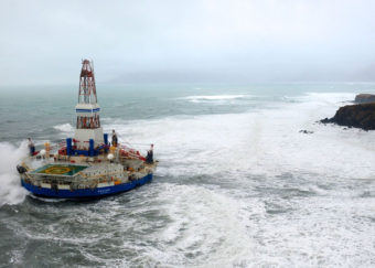
The Kulluk is an Arctic drill rig owned by Royal Dutch Shell. In 2012, the rig ran aground off Sitkalidak Island near Kodiak Island. The highly publicized incident was used by drilling opponents as an example of Shell's lack of qualifications to drill in the Arctic. (Photo by Petty Officer 1st Class Sara Francis/U.S. Coast Guard)
The Kulluk, an Arctic drill rig owned by Royal Dutch Shell. In 2012, the rig ran aground off Sitkalidak Island near Kodiak Island. (Photo by Petty Officer 1st Class Sara Francis/U.S. Coast Guard)

President Obama on Tuesday put nearly all waters in the U.S. Arctic off-limits for future oil and gas drilling. The White House announced the decision in conjunction with a similar statement from the Canadian government covering its Arctic waters.

The president used a rarely deployed power in the Outer Continental Shelf Lands Act to remove areas from leasing consideration for an indefinite period of time. The law includes no way for the next president to reverse his decision.

Since Shell halted its exploratory drilling in the Chukchi Sea last year, no company has seemed close to returning to federal waters in the Arctic. But Alaska officials and industry trade associations have been desperately trying to keep the door open to future activity in the area.

Joshua Kindred of the Alaska Oil and Gas Association looked with dismay at the map of the president’s new withdrawals.

Outgoing President Barack Obama ordered a withdrawal from Arctic offshore oil and gas leasing in the Beaufort and Chukchi seas on Dec. 20, 2016. (Graphic courtesy Bureau of Ocean Energy Management)
Outgoing President Barack Obama ordered offshore oil and gas leasing off-limits in much of the Beaufort and Chukchi seas. (Graphic courtesy Bureau of Ocean Energy Management)

“It looks like it’s virtually the entirety of the Chukchi and Beaufort Sea that would be exempt so, yeah, that’s about as absolute of a withdrawal as can be,” Kindred said.

The White House cited the area’s important ecology, subsistence and the health of marine mammals in explaining the decision. The action drew immediate praise from environmental groups. By acting jointly with Canada, supporters say the U.S. isn’t merely pushing development into Canadian Arctic waters. But Kindred said the announcement does nothing to lessen the risks of Russian drilling.

“And by us not having our own energy companies in the region, we are less prepared if there was an incident in the Russian Chukchi Sea, just miles away from U.S. Arctic waters,” Kindred said. “So it is a very sort of reactionary way to approach this.”

Obama made the withdrawals, just as environmental groups requested, using a provision of the Outer Continental Shelf Lands Act known as 12(a). It does not affect the rights of existing leaseholders.

Obama also left 2.8 million acres of the near-shore Beaufort, close to the existing oilfields and pipelines, outside of his withdrawal.

Though created with the stroke of a presidential pen, the Obama withdrawals could be tough to get rid of.

“12(a) says the president has the power to withdraw these lands. It does not give the president the power to un-withdraw lands previously withdrawn,” University of California-Hastings Law professor John Leshy said. Leshy was the top attorney in the Interior Department under President Bill Clinton.

Leshy said there’s “substantial doubt” President Donald Trump could issue an order undoing the Arctic withdrawal.

“It’s never been done, so we don’t have any judicial test of this,” Leshy said. “But there is related law that basically said when Congress gives the president the authority to do something, and does not give the president authority to undo it, the president doesn’t have the authority to undo it. So it is permanent.”

On the other hand, the law professor said it’s clear Congress can pass a bill to cancel a 12(a) withdrawal.

Alaska Congressman Don Young said he doesn’t buy the argument that the incoming president can’t cancel Obama’s decision.

“If I was the president, I’d just go ahead and tell his secretary of Interior, Mineral Management, to put it up for lease,” Young said. “Let them take it to court.”

Young, in a press release, called Obama’s action a “cowardly move by a lame-duck president.”

“I say he’ll go down as one of the worst presidents we’ve ever had,” Young said.

Young said he thinks the House will move a bill next year to undo this order and lots of other Obama decisions. He says it would easily pass the House but Young declined to speculate on its fate in the Senate.

Editor’s note: This story has been expanded.


Walker proposes stable Fish and Game budget

A state Department of Fish and Game staffer works on sampling fish for a study on toxic metal concentrations in Tulsequah and Taku river fish. (Photo courtesy Department of Fish and Game)

Gov. Bill Walker proposed cutting about 45 positions and $3.5 million from the Alaska Department of Fish and Game’s 2018 budget last week, significantly smaller than the $11.5 million in cuts over the last two years.

But, Walker’s proposal calls for no additional changes to the agency’s Southeast operations.

Fish and Game has taken about a 36 percent cut to its dedicated state funding over the past two years. The commercial fisheries division is one of the more susceptible divisions to state budget cuts because state funding is its largest revenue source.

Southeast fishery funding under Walker’s proposal remains about the same as in the 2017 budget.

The division would be able to sustain its Southeast operations under the proposal, Commercial Fisheries Director Scott Kelley said.

“Basically the projects across the board that we’ve got in Southeast Alaska for Commercial Fisheries Division are going to be the same as what we had in this fiscal year,” Kelley said.

The budget calls for four Southeast commercial fishery positions to be eliminated. Kelley noted that will be done through attrition, but said more positions could be cut after the budget is finalized.

“As you well know, there were special sessions and ultimately things were very different from the governor’s request,” he said. “The FY17 request was not what the FY17 management plan and the allocations look like. Things could change is the bottom line.”

Kelley said the commercial fisheries division cut 45 positions statewide over the past two years.

Most of those positions were eliminated last year.

“We basically look at each and every position as it becomes vacant,” he said.

Commercial fisheries also stopped collecting data in 2015 for several Southeast herring fisheries that haven’t opened in recent years.

Herring fisheries near Craig and Sitka are still being managed. Several other projects were on the chopping block as well.

“They included a golden king crab observer project, some miscellaneous shellfish dive assessment, quite a bit less aerial surveys, and then some personnel cuts,” Kelley said.

Fish and Game’s sportfishing and wildlife conservation divisions don’t expect any major changes during the next fiscal year. Both divisions are primarily funded through national taxes on fishing and hunting gear.

Hunting and fishing license fee increases will also take effect in January.

Hunting licenses about doubled and sportfishing licenses increased $5, up from $24. Net sales for tags and licenses were at about $29.5 million in 2015.

Both divisions took large state funding cuts over the past two years, but tax revenue and license fees have been able to supplement those loses.

Southeast’s Dungeness harvests lower than expected

Dungeness crab at Pike Place Market
Dungeness crab at Pike Place Market in Seattle, October 2011. (Creative Commons photo by jpellgen)

Commercial Dungeness crab fishing in Southeast Alaska this fall turned out to be below average in both harvest and participation and below what managers expected for the season.

Fishing closed in most areas of Southeast on November 30.

The fall harvest was approximately 403,000 pounds. That’s about 150,000 pounds less than last year.

Kellii Wood is a Crab Biologist with the Alaska Department of Fish and Game. She says they’ve seen harvests like this before but it’s been a while.

“It’s definitely down from previous years,” Wood says. “We have been lower but I believe it was in the 90s.”

Wood says the harvest is far below the five-year fall average of 732,000 pounds.

About one-fifth of the year’s harvest comes in the fall. This year was just a little below that.

Wood says the recent average is a bit skewed when you consider 2014. It was an unusually good year seeing the third highest fall harvest on record since the 1960s. That fall fishermen harvested about a million pounds.

“It was a big, big year so anything in comparison is going to seem really small,” she says.

This fall, prices were similar to the last few years, averaging $3.07 per pound. The value of the fall fishery is about $1.3 million dollars which is below the five year average of nearly $2 million.

The combined summer and fall season catch is worth over $7 million at the docks this year. That’s also below the recent average.

As far as crab numbers, Wood says managers expected a lower year.

“We’re definitely on a downward trend for the cycle,” she says. “Hopefully it will pick up here pretty soon. But it was expected that it would be lower considering that two years ago it was the highest so we’re on that downward swing for sure.”

Even though managers expected a lower year, they still predicted a much stronger harvest for the combined summer and fall fisheries. They estimated a harvest of 3.01 million pounds but are ending up with about 2.28 million pounds. Wood says that’s pretty normal.

“We typically overshoot on average,” says Wood. “Every once in a while our estimate will be under what was actually harvested.”

“But nothing of concern, no concern of over harvesting or anything,” I ask her.

“No, we don’t have any concerns,” she says. “It seems to be following that cyclical pattern.”

To get a better estimate, managers would need more information. While there were Dungeness stock assessment surveys done in the early 2000s, there are none now. Wood says there’s just not enough staff or money for it. So scientists are left with harvest data to monitor the population. They know that the crab are on a four to five-year life cycle and the commercial fishery sees the population fluctuate.

“It seems like every ten years maybe we have a big pop,” Wood says. “For whatever reason, it’s hard to say. Every five years we have a little rise and it goes up and down and then every ten years it seems to go up and then come down. And so it’s…we just don’t have a lot of information other than following the harvest looks like from year to year.”

On top of the downward cycle, the crab’s yearly timing might be a bit off this year because of the water temperature. Wood says this was the warmest water year in the last decade. They monitor temperatures through gauges on some pots in the red King crab survey.

“So the molt timing for crab could be off as well,” Wood says. “So, that might be why things have been not as abundant as they normally are. The cycle could be off a little bit. They could have molted earlier or later. We just don’t know.”

Participation in the fall fishery was also down. 115 permit holders reported landings this fall. That’s three less than last year and over 20 less than the year before.

District 8 which includes the Stikine Flats near Wrangell saw the largest harvest of the fall fishery. Fishermen brought in about 46,000 pounds. Just behind that was District 6, which includes Duncan Canal and the Wrangell Narrows near Petersburg.

A few areas near Ketchikan and Sitka remain open to Dungeness crab fishing until the end of February. Then the commercial fishery will remain closed until the summer season starting June 15.

Atlantic Ocean Area The Size Of Virginia Protected From Deep-Water Fishing

v
A deep sea red crab hangs out on a bubblegum coral in Phoenix Canyon, off the coast of Delaware.
NOAA Ocean Explorer

Coral in an area in the Atlantic Ocean stretching from Connecticut to Virginia has been protected from deep-sea commercial fishing gear, by a new rule issued this week by the National Oceanic and Atmospheric Administration.

The protected area covers some 38,000 square miles of federal waters, NOAA says, which is about the size of Virginia. It’s the “largest area in the U.S. Atlantic and Gulf of Mexico protected from a range of destructive fishing gear,” according to the NRDC, an environmental advocacy group.

A map showing the boundaries of the protected area. NOAA
A map showing the boundaries of the protected area.
NOAA

The new regulations prohibit the use of bottom-tending fishing gear at depths below 1,470 feet. Boats are allowed to cross the protected area as long as they bring the banned heavy gear on board while they do so, according to the text of the rule. It is set to go into effect on Jan. 13.

It’s named the Frank R. Lautenberg Deep Sea Coral Protection Area, in honor of the former New Jersey senator who was an advocate for marine conservation.

Coral grows extremely slowly and is vulnerable to damage from this kind of heavy equipment that drags along the sea floor. As the NRDC put it: “One pass of a weighted fishing trawl net can destroy coral colonies as old as the California redwoods in seconds.”

“They’ve lived a long time but they live in an environment that is cold, with huge pressure, without light,” Joseph Gordon, Pew Charitable Trust’s manager of U.S. northeast oceans, told Delaware Public Media. “And so fishing technology could damage them in a way that could take centuries to recover from.”

The area is also home to many other animals, the NRDC adds, “including the endangered sperm whale, as well as sea birds, sea turtles, tunas, sharks, billfish, and countless other species.”


A small bubblegum coral in Norfolk Canyon. NOAA Ocean Explorer
A small bubblegum coral in Norfolk Canyon.
NOAA Ocean Explorer


The Mid-Atlantic Fishery Management Council began to look into setting up a protected area here in 2013, and NOAA issued a proposed federal rule in September 2016. It was finalized on Wednesday.

John Bullard, Regional Administrator for the Greater Atlantic Regional Fisheries Office, hailed this rule as a “great story of regional collaboration among the fishing industry, the Mid-Atlantic Council, the research community, and environmental organizations to protect what we all agree is a valuable ecological resource.”

And Bob Vanasse, the executive director of Saving Seafood, which represents the commercial fishing industry, told Virginia’s Daily Press that he thinks this is “the right way to protect these resources.”

“This is a situation where the industry came together with the council, with NOAA and with environmentalists and came up with a plan that created a compromise that everyone could live with,” Vanasse told the newspaper. “It’s a bright, shining example of how to do it right.”

A bythitid snakes its way through a cluster of brightly colored corals and brittle stars in Norfolk Canyon. NOAA Ocean Explorer
A bythitid snakes its way through a cluster of brightly colored corals and brittle stars in Norfolk Canyon.
NOAA Ocean Explorer

Copyright 2016 NPR. To see more, visit http://www.npr.org/.

China Seizes U.S. Underwater Drone From International Waters, Pentagon Says

A Navy file photo shows T-AGS 60 Class Oceanographic Survey Ship, USNS Bowditch. The Navy says the ship's mission includes oceanographic sampling and data collection and the handling, monitoring and servicing of remotely operated vehicles (ROVs), among other things.
A Navy file photo shows T-AGS 60 Class Oceanographic Survey Ship, USNS Bowditch. The Navy says the ship’s mission includes oceanographic sampling and data collection and the handling, monitoring and servicing of remotely operated vehicles (ROVs), among other things. (Public domain photo courtesy U.S. Navy)

China has seized an unmanned underwater vehicle deployed by a U.S. Navy ship in international waters, according to Pentagon officials.

The seizure of the underwater vehicle took place Thursday, about 50 nautical miles northwest of Subic Bay in the Philippines, Pentagon Press Secretary Peter Cook said in a statement Friday.

The situation is unusual: U.S. Navy Capt. Jeff Davis told journalists there was no precedent for it in recent memory, NPR’s Tom Bowman reports.

The Pentagon said the USNS Bowditch, an oceanographic survey ship, had two unclassified “ocean gliders” — unmanned underwater vehicles (UUVs) — in the water, conducting “routine operations in accordance with international law.” The undersea drones measure things such as salinity and temperature.

The Bowditch was retrieving one vehicle when a Chinese warship pulled up, put a small boat in the water and retrieved the second UUV, officials told reporters.

The U.S. sent radio messages requesting that the drone be returned, the Pentagon statement said, but the Chinese ship merely acknowledged the messages and ignored the request.

No shots were fired by either vehicle, officials said, and the Chinese ship left with a final message that it was returning to normal operations — and with the drone.

The U.S. has issued a demarche — a formal diplomatic protest — and demanded the drone’s return, Reuters reports.

“We call upon China to return our UUV immediately, and to comply with all of its obligations under international law,” Pentagon Press Secretary Peter Cook said in his statement.

The incident occurred in the long-disputed waters of the South China Sea, where several countries have various overlapping territorial claims. China has been the most aggressive in claiming the strategically and economically significant waters as its own.

Satellite photos taken in the past few weeks appear to show a significant defense buildup on China’s artificial islands in the South China Sea. Beijing uses the artificial islands as part of the justification for China’s territorial claims — which were invalidated months ago by an international tribunal in The Hague, Netherlands.

That ruling is “legally binding, but all but impossible to enforce,” as NPR’s Anthony Kuhn put it at the time.

“The U.S. has consistently said it has no dog in the fight over conflicting claims in the South China Sea,” Michael Sullivan reported for NPR this summer. “But … the U.S. has conducted a series of high-profile freedom of navigation operations in the disputed waters, near the artificial islands China has created there.”

The drone seizure also comes amid fresh tensions between China and the U.S., following moves by President-elect Donald Trump that have unsettled decades of diplomatic protocol.

Trump spoke with Taiwan’s president by phone earlier this month, and told Fox News he “wouldn’t feel bound by a one-China policy” — the policy holding that Taiwan is part of China, which China considers essential for diplomatic relations. China responded to Trump’s latter comments by expressing “serious concerns.”

NPR’s Rob Schmitz wrote last month that it’s hard to tell how Trump’s presidency will affect ties with China, which has been spending “more than ever” to expand its military capabilities.

He noted that one Trump adviser said Trump would beef up the U.S. fleet to defend U.S. trade in the South China Sea — which directly conflicts with Trump’s campaign rhetoric.

The drone incident also could impact diplomatic relations with the Philippines.

The U.S. and the Philippines, a former U.S. colony, have been closely tied for decades; the two countries are treaty allies. In recent years, a rise in tensions between Manila and Beijing has led to a growing U.S. military presence in the Philippines.

But the Philippines’ new president, Rodrigo Duterte, has signaled a shift away from the U.S. and made overtures to China.

“There’s no doubt Duterte is trying to reset the Philippines’ fractious relationship with China, a falling-out based largely on Beijing’s recent territorial moves in the South China Sea,” Michael Sullivan reported for NPR this fall. “But there’s also little doubt that Manila’s relationship with Washington is on the rocks — and not just because of U.S. criticism of Duterte’s war on drugs, which has left more than 3,000 dead since the president took office in June.”

One expert told Sullivan that there’s widespread belief in the Philippines that the U.S. commitment to the Philippines is “limited,” and would not extend to substantive assistance for Manila in a real conflict with Beijing.

Copyright 2016 NPR. To see more, visit http://www.npr.org/.

Report: 2016 was Arctic’s warmest year on record, effects are cascading down into ecosystem

Svalbard ice pack
Ice pack near Svalbard (Creative commons photo by Luc Jamet)

2016 was not a good year for the Arctic with the continued warming of the air and sea water, and diminishing sea ice.

The National Oceanic and Atmospheric Administration on Tuesday released its Arctic Report Card for 2016.

It was the warmest year on record for the Arctic where the average air temperature is increasing at twice the rate as the global average.

This year was 6.3 degrees Fahrenheit hotter than 1900. Also, water temperatures in the Arctic were 9 degrees Fahrenheit higher than the recent average.

“The report card this year clearly shows a stronger and more-pronounced signal of persistent warming than any previous year in our observational record,” said Jeremy Mathis, director of NOAA’s Arctic Research Program and an editor of the 106-page report.

“Those warming effects in the Arctic have had a cascading effect through the environment, including down into Arctic ecosystems,” Mathis said.

Listen to the full story about the Arctic Report Card 2016:


Topping the list of the warmth’s cascading effects is this fall’s slow freezeup and continued decline of the Arctic ice pack.

The minimum Arctic sea ice extent in October tied for the second lowest since the beginning of satellite observations in 1979.

Thinner, more-fragile first-year ice now makes up the overwhelming majority of the Arctic ice pack, compared with 30 years ago when it was roughly a half-and-half mix with thicker, stronger, multi-year ice.

Temperature anomaly map
Temperature anomaly map from NOAA Climate.gov)

Dartmouth College’s Donald Perovich, another of the report’s editors, says the Arctic ice pack could recover if temperatures cool.

But he doesn’t think it’s likely.

“What we’re seeing right now is the first act of a three-act play,” Perovich said. “We’re seeing the fall freezeup has been very slow, and we have a record minimum ice extent. Act 2 will come in March when we see what the maximum is. And, Act 3 of course will be in September. I kind of await that with both anticipation and a little bit of concern.”

Download the 106-page Arctic Report Card 2016 (5.9 mb PDF)


It’s hard to predict when the Arctic Ocean will be ice-free in the summer or what the Arctic will look like in 10 years. But Mathis said Arctic communities should be concerned about diminishing access to subsistence resources.

“It’s getting harder and harder for them to harvest resources as the ice pulls back further and further away from the coast,” Mathis said. “That’s a place where we need to be focusing our attention and our efforts to help them either continue to find those food sources and to rely on those food sources. Or, think about ways that we can help them deal with the loss or the decline of the food sources.”

Mathis said one positive aspect of less sea ice and earlier melting is that it stimulates more growth of phytoplankton, the base of the marine food web.

“But, at the same time, that primary productivity is the mechanism in which carbon dioxide is moved from the atmosphere into the ocean, and that’s what ocean acidification is,” Mathis said. “So, we already see a rapid progression of ocean acidification in the Arctic. And, that seems to be accelerating as the ice melts back further and further and productivity increases.”

Watch a short video presentation about the Arctic Report Card 2016:

The Arctic Report Card also notes a shrinking Greenland ice sheet, and spring snow cover dropped to a record low in the American and Canadian Arctic.

Columbia University’s Marco Tedesco said the amount of snow melt affects hydropower production and fresh water reserves.

“But, also, it’s impacting the ecosystems around it. The snow melting sooner and faster is leaving a drier soil exposed to a warmer summer,” Tedesco said. “So, you might have more jobs. You might have more forest fires. So, this might have, of course, ramifications for the economy, for the population.”

Melting permafrost can also affect infrastructure development or construction in the far north.

Watch the news conference on Tuesday about the Arctic Report Card 2016 at the annual meeting of the American Geophysical Union in San Francisco:

The warming, largely greening tundra is now releasing more carbon than it is taking in, and scientists are worried that the immense amounts of carbon stored in the melting permafrost could eventually be released and alter weather and climate around the globe.

“It’s a reminder of what I think many of us in Alaska feel is happening right before our eyes. And, that the Arctic is changing so dramatically,” said Margaret Williams, with the World Wildlife Fund in Anchorage after reviewing the Arctic Report Card.

Williams doesn’t think we’ve passed the window of opportunity to take action on climate change, she said.

“At the state level, every state can make a difference on the policies on energy efficiency and conservation,” Williams said. “Then, as individuals, people can also make a difference in how they manage their own personal carbon footprint.”

This is the 11th year for the Arctic Report Card, a peer-reviewed report sponsored by NOAA that includes the work of more 60 scientists from 11 countries. The findings were presented Tuesday at the annual meeting of the American Geophysical Union in San Francisco.

Site notifications
Update notification options
Subscribe to notifications