Oceans

New network of tribes expands toxic shellfish testing

Sitka Tribe of Alaska fisheries biologish Jen Hamblen empties blue mussel meat into a blender. (Photo by Emily Russell/KCAW)

Shellfish is a staple in many homes throughout Southeast Alaska, but it also can be a hazard.

A new lab in Sitka tests regularly for shellfish toxins and now is teaching more than a dozen tribes in the region to do the same.

Global warming could increase the level of toxins, so tribes are working fast to take the mystery out of what’s blooming on their shores.

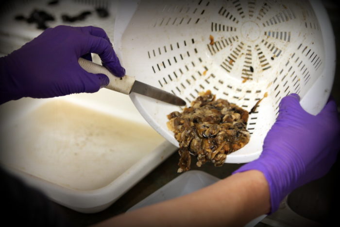
Jen Hamblen wears purple plastic gloves and a long black apron.

She’s shucking blue mussels, the kind you might find in a seafood restaurant.

“I love chowder,” said Hamblen, a fisheries biologist for the Sitka Tribe of Alaska. “I must say, my appetite for raw shellfish has decreased since I began this position.”

She’s scrapes the meat off the shells into a little white bowl.

When she has at least 100 grams worth of blue mussel meat, she empties the bowl into a blender.

She sets the timer for three minutes and turns the blender on high.

“The fancy word for that is ‘homogenization,’ but ‘shellfish smoothies’ is the other term we like to use,” Hamblen said, joking.

The tribe started blending up shellfish and testing them in the lab because of the growing concern over paralytic shellfish poisoning, or PSP.

Toxic algae blooms can contaminate shellfish, causing the sometimes fatal illness.

“People want to know, ‘Can we go out? Is it safe or is it not?’ Because it is an easy subsistence resource to harvest here,” she said. “There are shellfish everywhere.”

Michael Jamros directs the tribe’s research lab, which opened last year.

“When I showed up a year ago the lab was basically a bunch of boxes and I pretty much had to from there ordering the rest of supplies and getting the lab set up,” Jamros said.

It’s all set up and fully functioning now. That’s a good thing, since a study published last month reports that since 1997, the annual production of algae in the Arctic has risen by nearly 50 percent.

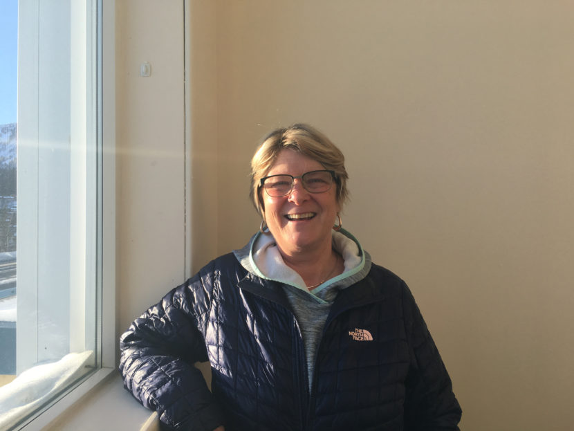
Chris Whitehead, the environmental program manager for the tribe, said warmer ocean temperatures make better breeding grounds for toxins.

“Just like your garden — if you water it and it’s warm and sunny out and you give it fertilizer — everything does really well,” Whitehead said. “It’s the same with these vegetative cells in the marine system.”

That’s why their weekly tests are so important, Whitehead said. And now more than a dozen other tribes in the region are also testing for toxins, including communities like Wrangell, Ketchikan, Juneau, Yakutat and Hoonah, Whitehead said.

“It’s a huge deal here,” said Ian Johnson, the environmental coordinator for the Hoonah Indian Association. “People are out digging all the time.”

“If I was just to guess, I would say over 50 percent of the community consumed clams, probably more. It might be 70 or 80 percent,” Johnson said.

Three people died in 2010 from paralytic shellfish poisoning, including one from Hoonah, and others have gotten sick since.

That’s why Johnson said people are eager for his weekly results, which he started releasing in October.

He soon ran into a problem.

People have different names for the same clams, like the Pacific littleneck clams — some people call them steamer clams.

Others, Johnson said, just differentiate between edible and inedible clams.

So he published an online survey about shellfish names.

“I was just trying to tap into this local base of knowledge and try to understand what people call these different species of clams so I can communicate the results better with them,” Johnson said.

Johnson released results from the survey online and continues testing the water for toxins each week.

If levels are unsafe, Johnson can send in shellfish samples to get blended up and tested in Sitka.

The batch of mussels in the blender right now is from Petersburg, a community 90 miles east of Sitka.

They were flown in just this morning.

After three minutes, the mixture is then run through a series of tests to determine if the mussels in Petersburg are safe to harvest.

Shellfish samples are flown in from other tribes almost every week, which helps Hamblen iron out the kinks in the lab.

Outside of the lab is a different story.

“A problem we encountered today is that there are frozen mussels on the beaches right now,” Hamblen said. “So, we’ll have to look at how to do sampling in Southeast Alaska when we have cold snaps like the one we’re experiencing now.”


Beth Kerttula returns to Juneau with a message: It’s time to plan for ocean’s future

Former state Rep. Beth Kerttula served as the National Ocean Council director for two years. She said marine planning is important.Dec. 9, 2016. (Photo by Andrew Kitchenman/KTOO)
Former state Rep. Beth Kerttula served as the National Ocean Council director for two years. She said marine planning is important. (Photo by Andrew Kitchenman/KTOO)

Former Juneau state Rep. Beth Kerttula returned to Alaska this summer after two years serving the White House as director of the National Ocean Council.

In this position, she helped two regions write the country’s first marine plans, and worked on some issues particularly important to Alaskans.

Kerttula said it’s important to plan for the future of the oceans that surround Alaska and the rest of the United States. She said just as people can have personal trauma when they don’t plan for their future, the U.S. oceans could face disaster.

“If you aren’t planning where your ship lanes are, if you’re not planning around the sea mammals, if you’re not planning so that you can have development, then you’re going to have a mess at some point,” she said. “And you’re going to have conflict between subsistence users, between the developers.”

The attraction of making a difference for the future of the oceans is why Kerttula left the Alaska House of Representatives in 2014, after 15 years.

The Juneau Democrat served as the minority leader for her last seven years in the House.

She spent six months at Stanford University’s Center for Ocean Solutions before she joined the National Ocean Council. President Barack Obama formed the council under an executive order in 2010. Kerttula explained why he did it.

“It’s a huge challenge right now with the ocean,” she said. “We’re facing some very severe problems: ocean acidification, erosion, sea-level rise, the lack of coordination among users, the lack of coordination among the federal agencies. And all of those things are really coming to a head.”

The National Ocean Council includes 27 federal agencies.

Kerttula worked with officials in all of the agencies to plan with state and tribal governments. The council adopted the first two marine plans on Dec. 2, covering the waters off of the Northeast and Mid-Atlantic.

She said planning is especially important for Alaska.

“We have so many conflicts,” she said. “And we have worse problems on the horizon, particularly in our ocean space. And this is just a really wonderful method to put all of the users, the stakeholders, the federal agencies, the tribes, at the table.”

Along with resolving conflicts, Kerttula said, the focus on planning can provide more information about coastal waters, such as mapping the seabed.

“We know so little about the ocean floor. We don’t even have charts,” she said. “I mean, in many parts of Alaska, we don’t have accurate charting. So it comes down also to health and safety.”

Kerttula was also engaged in efforts to stop illegally caught fish from being brought into the country.

“One of the things that was very shocking to me when I went Outside, spent so much time Outside these last two years, was the problem with illegal fish, I mean, not knowing what fish you were even getting many times in restaurants,” she said.

Kerttula ended her work at the end of June. Since Obama launched the National Ocean Council with an executive order, President-Elect Donald Trump will be able to end it with a stroke of a pen.

That has Kerttula worried.

“My hope is that there won’t be knee-jerk reactions about overturning the executive order,” she said. “But there’s a lot of concern about it, and about what that would mean. If that happens, the effort’s not going to stop, because you need something like this.”

She’s taking some time off now that she’s returned to Juneau, helping her husband, University of Alaska Southeast Professor Jim Powell, and her elderly father, former state Sen. Jay Kerttula.

Obama draws fury and joy with Bering Sea protection

Walrus
(Photo courtesy Bering Sea Elders Group)

President Obama today issued an executive order creating the “Northern Bering Sea Climate Resilience Area.” The area covers more than 100,000 square miles off Alaska’s western coast, from the mouth of the Kuskokwim to just north of the Bering Strait. The president’s order withdraws about 40 percent of the area from offshore oil and gas leasing. It also reaffirms an existing ban in the area on bottom-trawl fishing.

Alaska’s congressional delegation pre-reacted, before the order came out, warning the president not to close off any more of Alaska’s ocean. Sen. Dan Sullivan later said Obama imposed “a unilateral action to hurt Alaskans.”

But for 64-year-old Harry Lincoln, a subsistence hunter from Tununak, this isn’t a case of the president imposing his will on distant seas. Lincoln is chairman of the Bering Strait Elders Group. He said he was stunned to learn the president has acted on the urgent request of the 39 tribes Lincoln represents.

“It’s the happiest moment I ever had in my life!” Lincoln said.

Native American Rights Fund attorney Natalie Landreth said it’s a historic action.

“The level of presidential responsiveness to a group of some of the poorest and smallest native communities in the United States is the real story here,” she said.

She said the story began not in Washington, but in Bethel, in July of 2015, just before the president’s Alaska visit. The Bering Sea Elders were meeting and Landreth was there as their attorney. The elders, she said, were worried about the decline of sea ice and what the predicted increase in ship traffic would mean for the marine mammals they hunt.

“And then somebody said — I wish I could remember who: ‘Let’s ask the president for help.’ And I said, that’s what you’d call a hail Mary. And then I had to explain what that was,” Landreth recalled.

The term is applied to desperate efforts, with almost no chance of success. But, Landreth said, the elders resolved to try.

“Over the past 15 months,” the attorney said, “people from rural Alaska went to the president’s office and said, ‘This is what we need.’”

The order, she said, mirrors a resolution the Bering Sea Elders passed in June. Landreth said it can prevent the kind of conflict seen now with the Standing Rock Sioux over the North Dakota Access Pipeline, because a main theme of Obama’s order is the early inclusion of Bering Sea tribes in federal decision making that concerns their region.

“It’s not just the text of the order,” she said. “It’s the fact that the president would spend an inordinate amount of time to try to help these people. I’ve never seen that in my life. I’m not sure that we’re going to see it again.”

The area the president is withdrawing from oil leasing is roughly Norton Sound, the southern strait and around St. Lawrence Island.

Gov. Bill Walker issued a statement saying he supports tribal leaders in their efforts to protect their resources, but that he’s concerned about lost development opportunities for the state.

Landreth said the withdrawal doesn’t harm the economy because it has been offered and explored in the past, with no results.

“This is not a commercially viable area,” she said. “It just isn’t.”

And now that’s less likely than ever. Obama used a provision of the offshore leasing act known as 12(a). Drilling opponents maintain these kind of withdrawals are permanent. Alaska Congressman Don Young said he plans to ask the next president, Donald Trump, to reverse this order. That’s legally possible, but historically, these orders tend to endure.

Rachel Waldholz contributed to this story from Anchorage.

Obama creates ‘climate resilience area’ in Bering Sea

President Obama today issued an executive order creating the “Northern Bering Sea Climate Resilience Area” of 112,300 square miles.

The order aims to include local tribes in decision-making about shipping through the Bering Strait, among other activities in the area.

He also announced $30 million pledges from philanthropic groups for projects “related to shipping, ecosystem science, community and ecological resilience, and tribal engagement.”

The order withdraws 40,300 square miles from oil and gas leasing. For fishing, the order reaffirms an existing ban on bottom trawling. It is not, though, a “monument” designation, which some Alaskans feared would permanently lock up resources to development.

According to the White House:

The Northern Bering Sea Climate Resilience Area is delineated for the purpose of focusing a locally-tailored collection of protections related to oil and gas, shipping, and fishing. The order also establishes a Task Force charged with coordinating Federal activities in this area to enhance ecosystem and community resilience, conserve natural resources, and protect the cultural and subsistence values this ecosystem provides for Alaskan native communities. Further, agencies are directed to consider traditional knowledge in decision making and establish a formal consultative mechanism for engaging with regional tribal governments to seek their input on Federal activities.

This is a developing story.

Puffin die-off on St. Paul Island may point to larger ecosystem problems

St. Paul residents have seen 300 puffin carcasses wash ashore since mid-October. Scientists say seabirds are good indicators of overall ecosystem health, which means the die-off could be a sign of trouble for all sorts of species. (Photo by COASST Island Sentinels)

In the past two months, 300 dead puffins have washed up on St. Paul Island, alarming residents who had only seen six carcasses over the last decade.

The die-off appears to be slowing down now, but scientists say it could be the sign of a much larger ecosystem problem.

Lauren Divine didn’t panic when St. Paul residents found a few dead puffins on the beach in mid-October.

“The first day was a tufted puffin. The next day was a horned puffin. I didn’t think too much about it,” said Divine, co-director of St. Paul’s Ecosystem Conservation Office.

Within the week, she said it became clear something was wrong, as islanders found more and more carcasses.

They posted photos on Facebook and called ECO concerned. Divine took the first dead birds to Anchorage for research while her co-director hopped on a four-wheeler and hit the beaches to the gauge the extent of the problem.

“She called me up and said: ‘I’ve followed up on these citizen reports of puffins, and they’re everywhere. There are dead puffins everywhere.'”

The carcasses came ashore in waves.

Dozens at a time.

They washed up so fast most were still intact days later — a sign there were so many, scavenging foxes couldn’t keep up.

Divine said the extent of the die-off was frightening.

St. Paul residents began patrolling the beaches daily, and the ECO office had 10 dead puffins necropsied.

“After we opened up the first five, it was very apparent that all of them were emaciated,” she said. “Their muscles were completely atrophied. They had empty stomachs. They had gastrointestinal bleeding, which indicates severe long-term starvation. They were in very, very poor shape.”

The theory is that the puffins left the island and headed south to winter in the Bering Sea as usual. But when they couldn’t find food, they grew weak, starved, and were carried back to St. Paul by ocean currents.

“So we started digging into this more,” said Divine. “What is happening? Where is their food?”

To answer those questions, ECO enlisted help from the Coastal Observation and Seabird Survey Team, or COASST, based at the University of Washington. It’s a citizen science program that has 800 volunteers collecting data on seabirds from northern California to Kotzebue and Cape Lisburne.

Julia Parrish, executive director of the program, said all that local data helps piece together the big picture unfolding across the north Pacific Ocean, as well as the Bering and Chukchi Seas.

Right now, Parrish said the major force at work is a big patch of warm water called the Blob, and it’s affecting the entire marine ecosystem.

“Suddenly, it’s like the grocery store is full of new things — and less good things — to eat,” said Parrish.

The changes begin at the bottom of the food chain, with plankton and forage fish — the kind of fish that make up a puffin’s diet. Those small fish try to adjust to the warmth by swimming to different areas or diving deeper in search of cool water.

For the puffins on St. Paul, that’s meant widespread starvation.

In fact, Parrish said the 300 birds found dead may represent just 10 percent of the total die-off, when you account for carcasses that are probably blowing past the small island.

“That would mean those 300 birds scale up to 3,000 birds,” she said. “That’s half of the breeding population of the Pribilof Islands.”

The people of St. Paul don’t harvest puffins for subsistence, but Parrish said seabirds are good indicators of overall ecosystem health.

This die-off could be a sign of trouble for all sorts of species that residents rely on to fill their freezers.

“Can these populations sustain this kind of long-term change pressure? Boy, that’s a great question,” she said. “I wish I knew the answer. I can tell you I think it’s going to be stressful for them for a while.”

Back in St. Paul, Divine said it looks like the puffin die-off is slowing down, but the ECO office also is seeing signs of stress in other species.

She said the island’s seabirds laid barely any eggs this season, hunters had a hard time finding sea lions, and crab quotas were cut sharply after a survey showed low numbers.

“It’s all interrelated — from the smallest harmful algal blooms and phytoplankton issues to whale die-offs and loss of sea ice,” she said. “It’s absolutely all connected, and I think we’re so far past the point of needing some kind of conservation and management action — before it’s too late to give the ecosystem a fighting chance.”

But even for scientists, it’s hard to know what to do. As Parrish says, you can’t legislate water temperature.

So for now, that leaves the people of St. Paul to pick up dead birds from their beaches and monitor the changing ocean that surrounds them.

A surfer and his paddleboard embark on a lonely trans-Atlantic voyage

In 2010, Chris Bertish paddled into 25-foot waves en route to a win at the Mavericks Surf Contest, an annual competition at one of the world’s most famous (and nastiest) big-wave breaks. On Tuesday, Bertish paddled out to conquer something even more massive — roughly 4,600 miles larger, in fact.

The 42-year-old South African surfer and sailor set out to become the first person to cross the Atlantic Ocean unassisted on a stand-up paddle board.

The journey he has laid out for himself takes him from the Agadir Marina in Morocco, on the northwest coast of Africa, past the Canary Islands and Virgin Islands and straight through to northern Florida.

He expects the lonely voyage to take approximately four months.

The idea, however, has been three to four years in the making, Bertish told Surfline.com in an interview published last month. “All the logistics and preparation and planning and training has been exponential. It’s by far the most challenging thing I’ve ever tried to do,” he said.

The project, which he calls The Sup Crossing, has collected corporate sponsors and is soliciting donations. Bertish says the funds will go toward three charities: Signature of Hope Trust, the Lunchbox Fund and Operation Smile.

Though the open seas threaten rough waves and deceptive currents, Bertish told The New York Times that 90 percent of his challenge lies in just the first five days, as he battles the wind and currents to get farther out to sea.

Once he does, he expects to paddle about the length of a marathon each night, resting during the days to diminish the risk of exposure. And he’ll be doing all of this in a state-of-the-art vessel that belies the simple term “stand-up paddleboard.” After all, the Times reports, the $120,000 craft boasts a watertight cabin where Bertish can sleep, as well as “satellite weather forecasting equipment, logistics and routing services, stationary and hand-held VHF radios” — and, well, the long list goes on.

According to the project’s announcement this summer, Bertish will be using some of this equipment to record data not only on the environment through which he’s paddling, but also on himself.

“Data will be uploaded by Chris daily, which the Sport Science Institute [of South Africa] will assess and review and in turn formulate a full case study which will be used for research by students at the [University of Cape Town] Sports Science department,” the statement reads.

Perhaps it’s a relief there will be some more eyes on Bertish’s progress. The last attempt to make the trans-Atlantic journey by stand-up paddleboard, launched earlier this year by Nicolas Jarossay, ended quickly in disaster.

Just 30 miles into his attempt, SUP Magazine reports Jarossay’s board capsized, leaving him stranded and fighting off hypothermia as a rescue team tracked him down, finding him only by “an incredible stroke of luck.”

So far, at least, Bertish has already gotten farther than Jarossay. Only time — and thousands of miles of open sea — will tell if he gets all the way to his destination.

You can track his progress in real time here.

Copyright 2016 NPR. To see more, visit http://www.npr.org/.
Site notifications
Update notification options
Subscribe to notifications