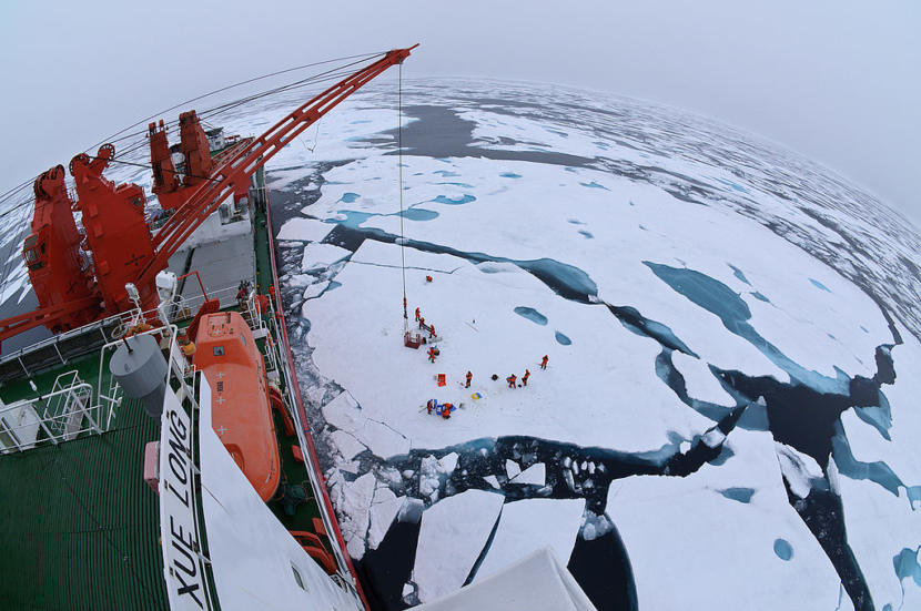
Drift ice camp in the middle of the Arctic Ocean as seen from the deck of icebreaker XueLong, July 2010. (Creative Commons photo by Timo Palo)
The United States and six other member nations of the Arctic Council are boycotting talks in Russia and will pause all international meetings to protest Russia’s invasion of Ukraine.
“The core principles of sovereignty and territorial integrity, based on international law, have long underpinned the work of the Arctic Council, a forum which Russia currently chairs,” Thursday’s joint statement reads. “In light of Russia’s flagrant violation of these principles, our representatives will not travel to Russia for meetings of the Arctic Council.”
The statement also says the seven member states are “pausing participation in all meetings of the Council and its subsidiary bodies” until it can figure out how to continue the council’s work “in view of the current circumstances.”
It’s an unprecedented development for the Arctic Council. It formed in 1996 with the idea that the Arctic should be a zone of peace and cooperation. Now, Russia’s war in Europe is spilling over into the region.
The seven countries are Canada, Denmark, Finland, Iceland, Norway, Sweden and the United States. The eight member nation is Russia, which is in the middles of a two-year rotating chairmanship. The next meeting of senior Arctic Council leaders was supposed to be in May in Arkhangelsk, a city in Russia’s western Arctic.
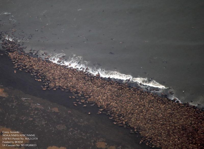
Thousands of Pacific walrus gather on shore near Point Lay in this aerial image captured during a NOAA survey of the Chukchi Sea. The arctic surveys serve to document the distribution and relative abundance of bowhead, gray, right, and fin whales, belugas, and other marine mammals in areas of potential oil and natural gas exploration, development, and production activities in the Alaskan Beaufort and northeastern Chukchi Seas. (Photo by Corey Accardo/NOAA)
Scientists from both the U.S. and Russia are using less invasive technology to get a more complete survey of the walrus population in the Bering Strait region. Their updated methods of surveying could lead to better management and protection of the subsistence marine mammal.
“With the help of Anatoly Kochnev and a team of biologists working there (in Chukotka), they were able to monitor five different sites using drones, and they also did controlled experiments in places where there weren’t too many walruses to determine what altitude the walruses will tolerate,” Fishbach stated.
The partnership helped scientists determine that if they flew a drone less than 50 meters above the head of a walrus, the walrus would be disturbed and flee, Fischbach said during a Strait Science presentation hosted by the University of Alaska Fairbanks Northwest Campus in Nome. But if the drone was flown higher than that height, then they would be able to safely conduct their surveys.
Fishbach says his team now flies drones about 100 meters above walruses, to be doubly sure they don’t disturb them. Overall, he thinks relying on drones rather than aerial surveys in small planes flown by private pilots is the better option.
“It’s much, much safer, not only for humans, but much safer for walruses. The best thing for us, is you can get more data. Whenever the weather breaks, the rain stops, and lays down, we can get out of our tents, launch this thing, get the survey done, and do it safely,” Fischbach said. “And the data is better too.”
Fischbach’s research team was able to fly 26 drone surveys in a span of two years to count walruses. That’s compared to the old method of flying planes for aerial surveys a few times a year, which was limited by costs, weather, and seasonal challenges.
Thanks to drone surveys, they were able to release “defensible numbers” from their annual walrus count at a previous Point Lay haul out, Fischbach said. The team estimated almost 60,000 walruses were on the beach during surveys taken at Point Lay in the fall of 2018 and 2019.
Once Fischbach and his team combine the survey data with information gathered from radio telemetry tags they placed on a number of walruses, then he says they will have a fuller picture of the regional population.
“And now that we have this methodology worked out, we can collaborate with partners in Northern Chukotka,” Fischbach said. “If they are interested, we can build a team, and we can do an estimate for the entire Chukchi Sea during that open water period.”
Anatoly Kochnev is one of the scientists who has been doing similar drone surveys on the Chukotka side of the Strait since 2017 and studying walruses for decades. Kochnev has also conducted aerial surveys of walrus, as well as focused on the local polar bear population in Chukotka for 30 to 35 years.
“The Pacific walrus is our shared resource, and Russia and the US need to work together to effectively manage and conserve the population,” Kochnev told KNOM via email. “Therefore, I really hope for continued cooperation. I think we need to focus on developing a simple and reliable method for regularly estimating population size – for example, using satellites is exactly what Tony [Fischbach] is doing right now. I would also like to continue monitoring the land walrus haulouts. In addition, we need to focus on tracking changes in the population associated with climate change.”
As scientists from both sides of the Strait gather better survey data of walruses, this data could be used to inform management practices for U.S. and Russian agencies and to protect the animals from increasing vessel traffic.
Fischbach pointed to numerous ships transiting up and down the Chukotka side of the Bering Strait, mostly going in and out of the Sea of Okhotsk.
“The main thing is that we’re able to provide near-real-time management information and let people know ‘oh, take that different approach,’ so don’t fly over them [the walrus] for the aviators. And the same thing for mariners. That can be provided to authorities and they can give advice to people. It can also be used to support haul-out based estimates we were working on before,” Fischbach explained.
One of the next goals for Fischbach and his research team is to do future population estimates of walrus using satellite imagery counting the animals directly from space.
The U.S. Fish and Wildlife Service does not yet know when they will do an updated survey of the Chukchi Sea walrus population, according to Fischbach.
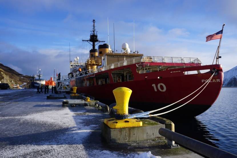
The Polar Star sits in the Port of Dutch Harbor in January, 2021. The ship is nearly 400 feet long and can break ice up to 21 feet thick (Photo by Hope McKenney/KUCB)
The nation’s sole heavy icebreaker arrived in Antarctica on Monday after a nearly three-month trip from Seattle.
The deployment marks the Polar Star’s 25th journey to the earth’s southernmost continent, supporting Operation Deep Freeze, an annual mission to resupply American scientists doing research near the South Pole, according to a Coast Guard statement.
Each year, the crew maneuvers the nearly 400-foot, 13,000-ton icebreaker to cut a channel to McMurdo Station, the U.S. Antarctic Program’s logistics hub. It carves through miles of ice, sometimes up to 21-feet thick.
This winter, the icebreaker’s 157 crew members spent four weeks breaking ice and grooming the shipping channel to the station, which was established on Ross Island in 1955.
The cleared route will enable two supply vessels to safely offload more than 8 million gallons of fuel and a thousand cargo containers. Together, the two ships carry enough fuel, food and critical supplies to sustain research operations throughout the year. Supply ships will return again during the next austral summer — the season in the Southern Hemisphere that runs from about November to February.
The mission marks the Polar Star’s first return to Antarctica since the start of the COVID-19 pandemic, according to the Coast Guard statement.
It was the ship’s first winter Arctic deployment in nearly four decades.
The Polar Star patrolled Alaska’s Arctic waters, including the maritime boundary line separating the U.S. and Russia, to assert maritime sovereignty and security in the far north and train the next generation of polar sailors.
Last winter’s patrol was the farthest north any American ship has sailed in the winter months.
The Coast Guard has been the sole provider of the nation’s polar icebreaking capability since 1965, according to the statement. Commissioned in 1976, the Polar Star is the United States’ only heavy icebreaker. The Coast Guard is increasing its icebreaking fleet with construction of three new polar security cutters “to ensure persistent national presence and reliable access to the polar regions.”
The construction on the first new icebreaker is expected to be completed in 2024.
Scattered sea ice near Nome, Alaska, March 15, 2019. (Photo courtesy David Dodman via KNOM)
Warm temperatures, melting sea ice, ocean debris and permafrost degradation dominated discussion of the 2021 Arctic Report Card by the National Oceanic and Atmospheric Administration.
NOAA Administrator Rick Spinrad summed up the overall feeling of disquiet.
“The trends are consistent, alarming and undeniable. Rapid and pronounced warming continues to drive the evolution of the Arctic environment. From this year’s report card, we learn that the October to December 2020 period was the warmest Arctic autumn on record dating back to 1900. The average surface air temperature over the Arctic this past year was the seventh warmest on record,” Spinrad said.
Deputy Lead Scientist Twila Moon of the National Snow and Ice Data Center addressed the issue of the Arctic’s rising temperatures specifically, saying the Arctic is warming at more than twice the rate than the rest of the globe.
“This means that the flora, fauna and peoples of the Arctic continue to experience rapid and often dramatic changes,” Moon said.
Moon stressed, however, that it is important not to oversimplify the Arctic ecosystem as one continually warming event. She pointed out that data can vary from location to location, and from season to season, painting a far more complex picture of the Arctic.
Lawrence Mudryk, who is a scientist from Environment & Climate Change Canada, had a presentation that touched on melting sea ice. Ice coverage of the Arctic seas has declined greatly over the past few years, according to the report card findings. Notwithstanding a few ups and downs in sea ice extent in the past few years, Mudryk noted that scientists have observed the fifteen lowest extents of sea ice all within the last fifteen years.
Mudryk pointed out that diminishing sea ice contributes to warming Arctic temperatures, not to mention negatively impacts Indigenous peoples who have depended on sea ice for their way of life for centuries.
“Sea ice’s high reflectivity plays an important role in regulating the amount of sunlight that enters the Arctic region and thereby helps to regulate its temperature. As sea ice disappears, the underlying ocean surface is exposed, and this much darker ocean surface will absorb sunlight and thereby allow a lot more heat to enter the Arctic system,” Mudryk said.
Gabriel Wolken, a research professor at the University of Alaska Fairbanks, presented on the state of the Arctic’s permafrost. He dwelt on the degradation of some of the Arctic’s once stable permafrost and the implications these changes have for the plants, animals, peoples and structures housed in a permafrost environment. A greater familiarity with the conditions and locations of permafrost degradation will help scientists identify trends, Wolken said. A sounder understanding translates to a stronger ability to help affected communities navigate the hazards of warming permafrost.
The last presenter, Kaare Sikuaq Erickson of Unalakleet with Ikaagun Engagement, ended on a positive statement. Alluding to how he witnessed his people come together and call upon their traditional values of sharing and cooperation during the ongoing hardships of the pandemic — when access to outside food was limited. He called for cooperation in the Arctic.
“I think people need to put their differences aside and work together on things. The polarization of our society is not helping anything. In the Arctic, we really do have to put things aside and focus on practical solutions. Otherwise, we won’t survive. I think the rest of the world is going to have to face that as well,” Erickson said.
He pointed out that cooperation has been one of the great strengths of Alaska Natives.
“We really did fall back on that kind of communal sharing, relations with others in our villages … because these are lifelong dependencies on our neighbors,” Erickson said.
The 2022 Arctic Report Card will be released at the end of the year.
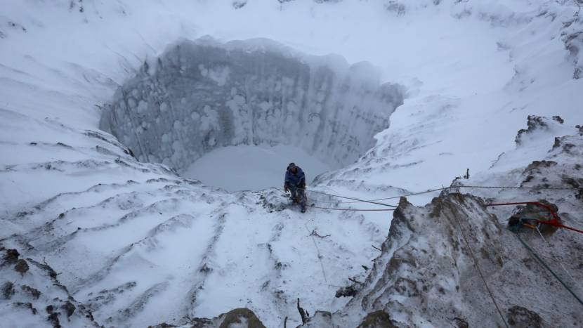
A member of an expedition group stands on the edge of a newly formed crater on the Yamal Peninsula in northern Siberia in November 2014. (Photo by Vladimir Pushkarev, Reuters via Nova and Geophysical Institute)
Arctic methane explosions and the scientists who love to study them are the focus of the newest episode of the public television program Nova.
The show follows University of Alaska Fairbanks researchers investigating the appearance of craters, sometimes big ones, in northern regions. That’s where a rapidly warming climate has thawed permafrost and allowed more methane to percolate upward from deeper in the Earth. As the thinking goes, the methane travels upwards and forms a kind of tube, not unlike magma in a volcano, and then builds up pressure at the surface until — kaboom! — it erupts, sometimes even with a fiery explosion.
Longtime permafrost researcher Dr. Vladimir Romanovsky with UAF’s Geophysical Institute, a professor emeritus as of this week, is featured in the Nova episode that aired Wednesday night. And Romanovsky says there are several reasons to keep an eye on the exploding methane phenomenon.
Listen here:
The following transcript has been lightly edited for clarity.
Vladimir Romanovsky: So it’s still in discussion, the process, the physical process behind this phenomena. But I think it’s more and more clear that there is some protrusion of high pressure gas, and this protrusion goes from below the bottom of permafrost toward the surface. And eventually, when the pressure is high, then it just erupts and removes this cap. And these pieces of frozen material and the big chunks of ice are flying away, very far sometimes, like 300 feet and even more away from the crater. And sometimes even there is some evidence that during this eruption, coming out, methane was ignited, and it was not just eruption, but eruption and then explosion. And yeah, people are aware of it, and they are monitoring. And of course, the satellite data is high, very high resolution, and are also now used very, very widely to, first of all, to look for these existing craters and how they change with time, but also looking at suspicious, little hills, round hills, the right size, and potentially could be those ones ready — sooner or later — to explode or to erupt.
Casey Grove: Some of those hills, maybe now you’re thinking, they’re not full of ice, they might be suspiciously full of methane, then?
Vladimir Romanovsky: Yeah, and not just full, but this high pressure. So it makes it dangerous to try to just simply drill into these hills. You may not survive, you know, because the pressure is very high, and also possibly there could be ignition. So it would make a really serious explosion and definitely will be not safe. Definitely. I wouldn’t recommend anybody to drill in those in those hills.
Casey Grove: I will note that for future reference, in case I find myself in that position.
Vladimir Romanovsky: Yeah. Just stay from a distance and look.
Casey Grove: Why is this happening? I mean, why is this showing up here relatively recently?
Vladimir Romanovsky: That’s a very good question. Why now? Why not before? And, of course, what really happened, what changed? Well, the climate warming. So that’s why, the first kind of reaction to explain why now. It’s related to a warmer climate, and why a warmer climate would trigger this, this phenomena, that’s where we need to have a very good understanding of the physics, the processes behind it. I have a very possible scenario why it is happening. And this explanation is, well, pretty straightforward. So this protrusion from below may be happening for a long, long time. But before, the permafrost was much colder. We have data, we have our measurements, going on for the last 40 years. And we see that, for example, permafrost on the North Slope now is about 3-4 degrees warmer near to the surface of permafrost, compared to 30-35 years ago. So now, warmer permafrost will allow this protrusion to come closer and closer to the ground surface and eventually allow these eruptions.
Casey Grove: And I guess the concern isn’t just that you might be standing nearby and the thing would explode, or if you were drilling into it or whatever, it has to do with the actual methane being released into the atmosphere. Can you explain that?
Vladimir Romanovsky: Yeah, that’s true. And the amount of methane which will be released during the eruption is not that much. And especially if it explodes, then methane will just turn into CO2 and water, pretty much. But if this chimney or connection to below permafrost environment will be still open, which we see in some cases — it’s still open in this case — it’s allowed to escape a much, much larger amount of methane, which is sequestered there and otherwise will be sitting there for, you know, millennia, it will be able to escape to the atmosphere. It’s still a question of how much. It’s still a question, it needs to be assessed and estimated, but it may be one of the potential sources of increase in methane concentration in the atmosphere, increasing this greenhouse effect, because it’s a very, very potent greenhouse gas.
Casey Grove: And that would just sort of cause a feedback loop and maybe even make the problem worse, I imagine?
Vladimir Romanovsky: That’s right. Yeah, the more greenhouse gas concentration, faster warming. Faster warming and permafrost thaw, more right conditions in more areas where it isn’t possible right now, and more explosions and so on. But I wouldn’t kind of neglect the possibility of problems with infrastructure with that, because according to my theory, this phenomena happens in the areas of warmer permafrost. And also, we know that any large infrastructure makes permafrost warmer. So in this case, this protrusion will actually be directed toward the warmer permafrost, which is under infrastructure, and that makes it very dangerous. So, you see, it’s kind of some sort of heat-directed missile, you know. It goes to the source of heat. Of course, it’s speculation. Of course, it’s kind of like an interesting twist in this phenomena, but it’s possible.
Casey Grove: Yeah, that does seem pretty troubling, and also interesting, just that, if that’s the case that it goes toward those things, it definitely seems worth studying more.
Vladimir Romanovsky: Right. And in the Yamal Peninsula, in Siberia, several of them have already happened. And very, very close to this Bovanenkovskoye gas field infrastructure, to the pipelines. So for them, it’s not a theoretical, potentially possible problem, but it is real problem. They’re already pretty much worried about what is going on there.
Casey Grove: Wow, yeah. And also I thought I’d ask, while I have you on right now, about your retirement, because I think I read that you are retiring from the Geophysical Institute after something like 30 years, right?
Vladimir Romanovsky: Right. Well, it’s my second day of retirement today.
Casey Grove: And you’re still talking to me while you’re retired?
Vladimir Romanovsky: Well, I am a professor emeritus, which allows me to be active and to be present at the Geophysical Institute. So for for a while, they will keep some office for me, and I have even free parking. So that’s my privilege. So I will be around as a professor emeritus, and I will talk to anybody who would like to know more about permafrost and permafrost-related questions.
Casey Grove: That’s great. And, I mean, as a former UAF person myself, I know that the parking really does matter. You know, Dr. Romanovsky, I thought I would ask, just as a Fairbanks person myself — and, you know, having been born there, I didn’t have much of a choice — but I like to ask people that moved to Fairbanks, why did you end up there? How did you end up in Fairbanks?
Vladimir Romanovsky: Well, Fairbanks is very, very proper — and obvious even — choice for a person who studies permafrost. My previous life, scientific life, was related to Moscow State University, which is in Moscow. And even in all American movies about Moscow, it’s always winter and it’s always snowy. There is, unfortunately, no permafrost around Moscow. And to study permafrost, we had to go far, far away from it. And Fairbanks is a great place. It’s a great place. First of all, because permafrost is just around — just outside. But also because the University of Alaska Fairbanks and the University of Alaska in general, it’s a very, very great scientific institution. So it’s a worldwide kind of leader in the cold regions research. And it’s a great place to be to study permafrost, because I have the huge knowledge of people around me. And any question I have, outside of my expertise, I can go and simply ask and work with those people around me. So that was great place, great decision on my side to come here and I’m very happy to be here.
Casey Grove: It sounds like you’re not leaving anytime soon for somewhere warmer, where you don’t have to just drive up the haul road to do permafrost research.
Vladimir Romanovsky: No, I will be here for a while, yes. It’s not easy to get rid of me.
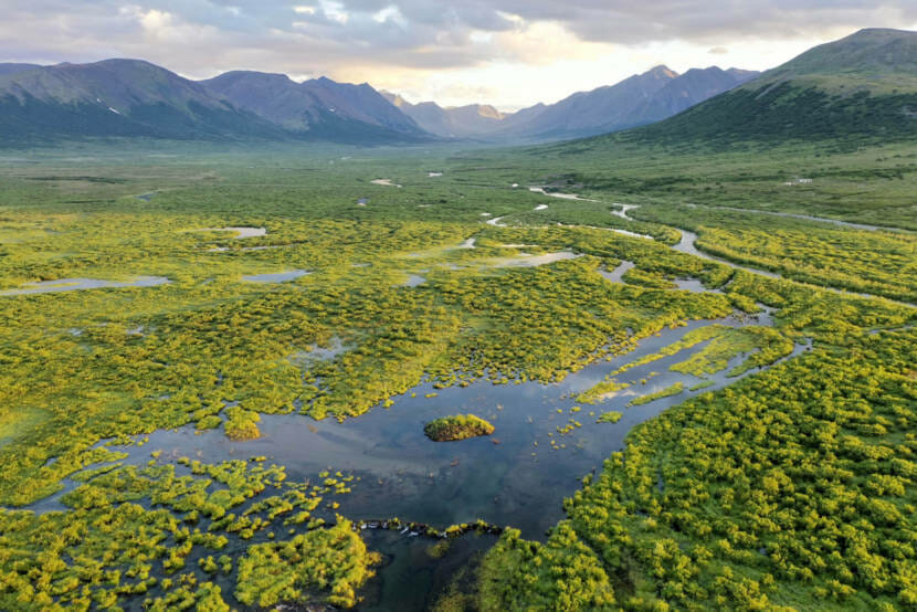
As Arctic tundra warms and thaws, incursions of shrubs and small trees have created new habitat for beaver, which create ponds and wetlands that further transform the once-frozen landscape. (Courtesy of Ken Tape)
Beavers are moving to the Arctic as the Alaska tundra heats up and the beaver population rebounds after centuries of trapping. A study published in December shows the small, industrious mammal is accelerating climate change in the north.
Beaver ponds are showing up in places they’ve never been before. For the past five years, ecologist Ken Tape has used satellite imagery and old aerial photos to map where beavers have dammed streams and created ponds. The University of Alaska Fairbanks professor says he was shocked by the magnitude of change.
“If it were a few streams, it wouldn’t be a big deal,” Tape said. “But it’s a lot more than that.”
Satellite imagery shows beavers have built upwards of 12,000 new ponds in the last half century. The beaver pond count doubled in the last 20 years. That’s bad news for melting permafrost. Tape and his fellow researchers have long tracked the effects of climate change on permafrost thaw and Arctic vegetation and water, but they were really surprised by the effects of beavers.
“When we got to beavers, it was like, ‘Whoa, you get some beavers in on some stream, and it’ll never look the same again.’ I mean, it’s just so transformational, what they do. It affects all aspects of lowland ecosystems: fish, permafrost, water, chemistry, boat travel, I mean, you name it,” Tape said.
When beavers dam a stream, it creates a pond that’s deeper than the stream was, and it retains more heat. Tape says if you liked the Arctic the way it was, this is not a good thing. He says to think of ponds as little oases for creatures that don’t usually live in the Arctic. They thaw permafrost and release carbon dioxide. It’s a case where increased biodiversity isn’t healthy for the native ecology.
“The landscape is falling apart with permafrost thaw, and beavers are that trend on steroids. And one of the big reasons is that permafrost is really rapidly impacted by changes in hydrology and surface water. And that’s precisely what beavers do,” Tape said.
The full effects of these new beaver ponds on fish and water quality aren’t clear yet — Tape says last season kicked off what will be about five years of field study around Nome and Kotzebue. He says he has an idea of the big picture, but it’s the people in Arctic communities who can help him learn how beavers are changing life and livelihood in the North.
Close
Update notification options
Subscribe to notifications
Subscribe
Get notifications about news related to the topics you care about. You can unsubscribe anytime.