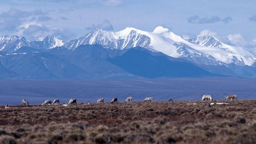
Caribou graze on the coastal plain of the Arctic National Wildlife Refuge, with the Brooks Range as a backdrop in October 2010. (Public domain photo by U.S. Fish and Wildlife Service)
Gov. Mike Dunleavy wants the state government to sever its ties with financial institutions that won’t finance oil and gas development in the Arctic.
Dunleavy announced in a news release Monday that his administration will introduce a bill during the upcoming legislative session that would require state departments and agencies to end any existing relationships with the businesses.
The proposed move by Dunleavy follows a string of announcements from major banks and lenders that say they won’t invest in oil and gas projects in the Arctic. Those companies include Wells Fargo, Bank of America, Goldman Sachs and JPMorgan Chase.
Environmental groups trying to block drilling in the Arctic National Wildlife Refuge have lobbied the banks to rule out investing in Arctic oil development.
Monday’s news release from the governor’s office said the proposed legislation would “protect Alaska’s economy.”
“It makes no sense for Alaska to allow financial institutions to benefit handsomely from Alaska’s financial activities on one hand, while working against our interests on the other,” Dunleavy said.
The exact impact Dunleavy’s proposal would have on state agencies wasn’t immediately clear.
Jeff Turner, the governor’s spokesman, said the scope of the change would be included in the draft legislation, and he said that document was not yet available Monday. He also said he did not have a list Monday of the financial institutions that the proposal would bar state agencies from using.
Alaska Wilderness League, a vocal opponent of drilling in the Arctic, swiftly criticized Dunleavy’s plans to introduce the bill, saying the governor is missing the broader point that “speculative, high cost projects in places like Alaska’s Arctic are no longer attractive to investors, especially with the realities of climate change and as more lucrative opportunities in renewable energy or unconventional oil plays down south exist.”
The federal government plans to hold its first-ever oil and gas lease sale in the Arctic refuge’s coastal plain on Jan. 6.
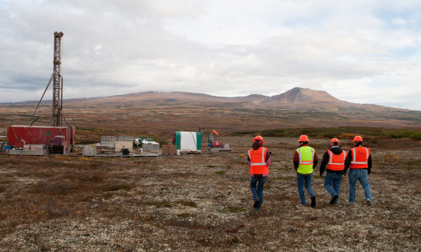
Members of the media walking up to an exploratory drill rig in 2012. (Photo by Jason Sear/KDLG)
A shareholder of Northern Dynasty Minerals is filing a class-action suit against the company and its directors for allegedly misleading shareholders about the viability of the proposed Pebble Mine. People who bought stocks between Dec. 21, 2017 and Nov. 25, 2020 have until Feb. 2, 2021 to join the lawsuit as lead plaintiffs.
Canadian-based Northern Dynasty is the parent company of the Pebble Limited Partnership, which has been promoting the mine to investors for more than a decade.
The U.S. Army Corps of Engineers last month denied Pebble a federal permit. It said that the project went against Clean Water Act guidelines, as well as the public interest.
The lawsuit holds that the company did not disclose to its investors that the proposed mine was contrary to the guidelines and public interest. The lawsuit also cites the secretly-recorded “Pebble Tapes,” which the Environmental Investigation Agency, an environmental group, released in September. In the tapes, Northern Dynasty CEO Ron Thiessen and former Pebble CEO Tom Collier say that once the mine went into production, the company planned to pursue a larger mine and extend its lifespan beyond what was being proposed.
Because of that, it alleges, Northern Dynasty misled the public and violated the Securities Exchange Act of 1934. That act is aimed at promoting greater transparency and requires that companies disclose relevant financial information.
The suit claims that in doing so, Northern Dynasty artificially inflated its stock prices. It holds that had investors been aware of the situation, they would not have bought shares at that price, or at all.
Northern Dynasty declined to comment for this story.
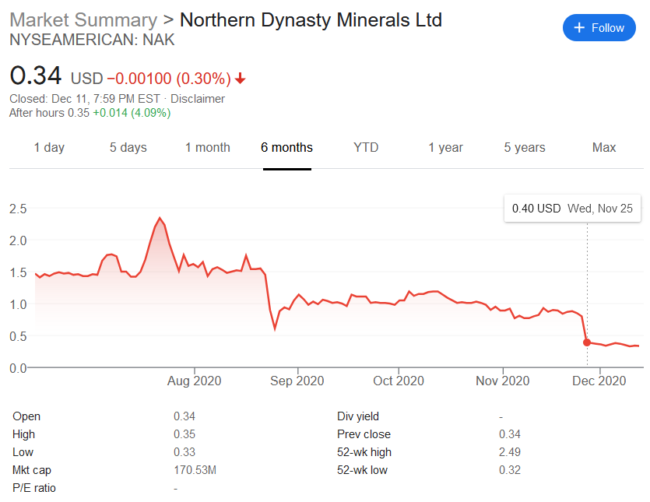
Screengrab of the Google Finance Market Summary for Northern Dynasty Mineral (NAK) shares. Dec. 12, 2020. (Source: Google Finance)
The months leading up to Pebble’s permit denial were rocky for the company, and that was reflected in its stock prices. The suit claims that that damaged investors.
When the Army Corps announced in August that Pebble needed to submit a new plan to mitigate the impacts to wetlands, the lawsuit points out the shares dropped by almost 38%, and when it denied Pebble a federal permit at the end of November, Northern Dynasty stocks dropped almost 50%, to 40 cents a share. As of Friday, they were at 34 cents a share.
The next annual Northern Dynasty shareholder meeting is on Dec. 17 in Vancouver.
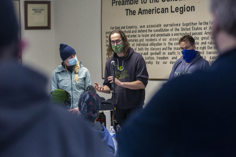
State geologists answer questions about instability, landslides, weather and what the future holds on Sunday, Dec. 6, 2020, in Haines, Alaska. (Photo by Rashah McChesney/KTOO)
Last week’s storm and landslides revealed that much of Haines, where there are no building codes, wasn’t constructed with landslide risk in mind. About fifty families had to evacuate their homes last week; another third of town is still on evacuation warning. Experts say that as the climate changes, wetter weather means some homes will become unsafe.
The road down to Teri Bastable-Podsiki’s property is lined with cars. There’s a moving truck packed to the gills out front.
She evacuated last week and has been staying at her ex-husband’s place—with about a dozen family members and 8 dogs. On Tuesday, a group of geologists visited and didn’t like the looks of the new cracks in her walls and plaster. Then, they thought the road shifted. She grabbed her family photos.
Ter Bastable-Podsiki was told her home could slide. Her parent’s wedding rings were among the first items she grabbed. Dec. 8, 2020. (Stremple/KHNS)
“I called my son and asked him to leave work for 10 minutes just to help load it with my son in law. And before I knew it, there were dozens of people here and a moving van and taking everything out of the house. And I’m just, I’m so overwhelmed with gratitude,” she said.
Within an hour and a half it looked like a moving crew had come through her Picture Point property. But it turns out the road didn’t shift. This time.
Bastable-Podsiki’s home is in a zone below Mt. Ripinsky that geologists are calling “the slump.” It’s an area of silt and clay that slides when it is inundated with water.
It has slumped before. Earth movement shifted Lutak Road and damaged the home in 2012. The borough declared a disaster. Engineers from Seattle recommended $1.6 million in drainage updates. But that never happened.
“The mountains are beautiful, but they are also dangerous,” said Ronald Daanen, a visiting geohydrologist for the Alaska Division of Geological and Geophysical Surveys.
When he’s not crunching mountainside data, he’s driving around Haines in a Chevy Astro to measure water pressure, an indicator for mudslides. When it’s high it means there’s pressure building underground. That can lead to a slide.
“What I see around town is a level of unpreparedness in terms of hydrological events. So, a lot of development is going on, people building houses where they think they want to live, which is fine. But all the construction, it seems, has clearly a lack of hydrological understanding of this environment,” he said.
That’s not unique to Haines. Like many rural areas in Alaska, it does not have a building code. It doesn’t have an up-to-date emergency mitigation plan either. That’s a map of potential hazards and a blueprint for how to respond.
Daanen says that even though there are people who know things should be done better, there just isn’t the money to support it. So, even when planners and permitting bodies want to keep people safe, they don’t have the resources to do it.
Brad Ryan used to be the Facilities Director in Haines. He was around while the then-borough planner tried to update the hazard mitigation plan.
“It’s a massive undertaking to understand what the hazards are, when it comes to your small communities, in particular with there’s not a lot of resources,” he said.
“And obviously, we’re in Southeast Alaska, there’s not a lot of things that are developed. So every time to move into a new area, you have to think about another evaluation of the hazards in those areas. So it’s money, it’s people, and it’s also we’re small relative to the area surrounding us.”
The consequences are real. Landslides aren’t what people think of when considering climate change — it’s usually sea level rise and hurricanes. But since the state declared a disaster in Southeast Alaska last week, Daanen says 20 communities in the region have asked him to do aerial surveys on mountains and steep terrain surrounding development.
He says there’s only so much prevention money can buy. And communities often resist building regulation. Even with updated and maintained culverts, a new hazard plan, and aerial surveys, there’s no predicting nature.
For the moment, blue sky reflects off of fresh snow on mountains surrounding Haines. But increased rain and storms — like last week’s — are in the long term forecast.
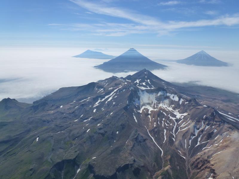
Aerial photograph of volcanoes of the Islands of Four Mountains. Mount Tana is in the foreground and Mount Herbert, Mount Cleveland and Mount Carlisle are shown left to right in the background. (Photo courtesy of John Lyons/USGS)
In a new study, scientists say a group of volcanic Aleutian Islands could be part of a massive, single, undiscovered volcano.
While scientists have been compiling their research for six years, there’s still a lot to piece together, according to Diana Roman, a volcanologist with the Carnegie Institution for Science in Washington, D.C.
“This is a little bit like trying to put together a 2,000-piece jigsaw puzzle, where half of the pieces are missing, and you don’t have the box, so you don’t know what it’s going to look like,” she said.
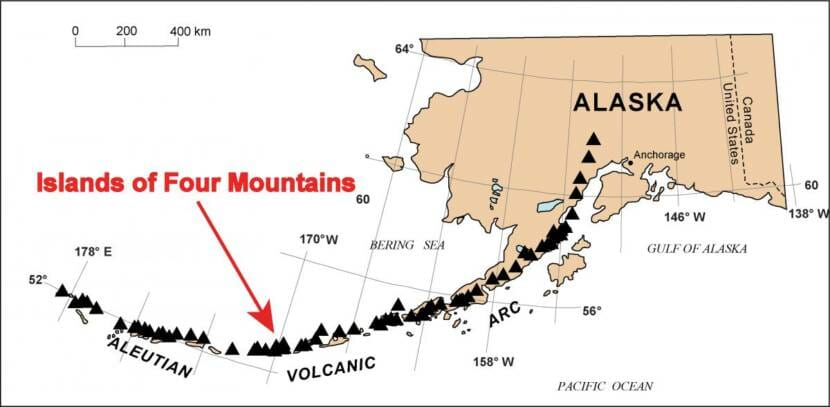
Roman is one of a number of scientists from across the country studying whether a giant volcano is hiding beneath the Islands of Four Mountains — a string of eight volcanic islands in the central Aleutians, about 170 miles west of Unalaska.
Map of the Aleutian Volcanic arc showing the positions of volcanoes (black triangles) and the location of the Island of Four Mountains. (Image courtesy of The Alaska Volcano Observatory)
On Monday, researchers presented their findings at the American Geophysical Union’s fall meeting.
John Power is a geophysicist with the U.S. Geological Survey at the Alaska Volcano Observatory, who also led the presentation at the virtual conference this week. He said the research in the Islands of Four Mountains started in 2014 because of the frequent eruptions at Mount Cleveland, which occupies the entire western half of Chuginadak Island.
“Mount Cleveland, over the last 20 years, and perhaps much longer, has been the most persistently-active volcano in North America,” Power said.
Scientists at the AVO have struggled with how to do a better job of warning people about potential eruptions at Mount Cleveland because it is so active, according to Power. But after studying the large stratovolcano and the other five located nearby, multiple pieces of evidence led them to the conclusion that there might be a 12-mile-wide caldera — a large volcanic crater — or a number of calderas, hidden underwater beneath the group of islands, which might help explain the frequent explosive activity seen at Cleveland.
Power said the evidence includes a type of rock scientists found there — called ignimbrites — that’s formed from large, catastrophic caldera-forming events, a slight change in gravity where they think the caldera might be, the extensive geothermal and hot springs throughout the islands, the earthquake activity there — and most notably, he said, the semi-circular arrangement of the islands which might form the caldera’s rim.
“There are multiple pieces of evidence that have come together, that make us think that this is also a very large, caldera-type volcano, which was previously unrecognized for two reasons. One is that we all know the Islands of Four Mountains are very remote, and the volcanoes there have not received a lot of prior study,” Power said. “And, in this case, much of the caldera structure is likely under the Bering Sea, so it’s been hard for people to identify.”
But Power and Roman say the caldera’s existence is not yet proven. To find out if the islands form one big caldera or whether there are multiple calderas side by side, or even if there’s a caldera there at all, they’ll have to return to the Islands of Four Mountains to gather more evidence to fully test their hypothesis.
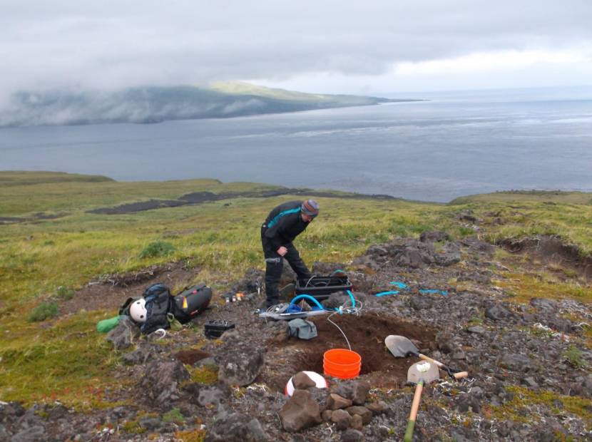
Former Carnegie postdoc Amanda Lough inspects a seismic station on Cleveland Volcano. (Photo courtesy of Carnegie Institution for Science)
If the researchers’ suspicions are correct, the newfound volcanic caldera would become the first caldera to be discovered in the Aleutians that is hidden underwater. It would also belong to the same category of volcanoes as the Yellowstone Caldera and others that have had super-eruptions with profound global consequences.
“If you look at some of the other large caldera-forming eruptions — such as Okmok — you do see that these have resulted in cooling of the climate,” Power said. “In 1815, there was a very famous eruption at [Mount] Tambora in Indonesia, about this size, that resulted in what’s called the ‘year without a summer’ — there were crop failures, pandemics.”
According to Power, understanding where and when large volcanic eruptions occurred is important in understanding the global impacts they can have.
But, he said, there’s no immediate cause for concern that there will be a super-eruption at the site of the caldera in the Islands of Four Mountains. Rather, he said, knowing that there is potentially a caldera system there will help agencies such as the AVO anticipate eruptive activity moving forward and identify the types of hazards it may pose to overflying aircraft, fishermen and nearby communities such as Nikolski and Unalaska.
“It does not mean that there will be a huge eruption coming from this caldera anytime soon,” Power said. “It may be thousands of years or potentially never.”
Scientists are currently planning their next expedition to the Islands of Four Mountains, which could be several years out, Roman said. The last major expeditions to the islands were in 2014, 2015 and 2016.
Tenakee resident Gordon Chew holds a GoPro in the water to gather footage of a nearly 40-foot humpback whale entangled in Tenakee Inlet, while resident Steve Lewis carefully maneuvers the skiff. (Photo by Rachel Myron/NOAA permit #18786-04)
It was the middle of the night on the day before Thanksgiving when a gut-wrenching sound awoke residents in the Chichagof Island town of Tenakee Springs.
“It was a pretty sad and mournful and awful sound,” resident Wendy Stern said.
Resident Steve Lewis described it as a plaintive cry for help.
“It was just this sort of whistling and groaning,” Lewis said.
Neither of them actually heard the noises until later in the day when the sound carried closer to their homes. But they were among the first to respond to its source — a 40-foot humpback whale caught in tanner crab pot gear that, resident Gordon Chew said, came from Kodiak around 630 miles away.
“People were very shaken up after losing a lot of sleep and listening to a bellowing humpback whale all night,” Chew said. He awoke to calls from those distressed residents.
Large whale entanglements are fairly rare in Alaska. Only around 10 are spotted each year, and most whales shed the marine debris or fishing gear on their own. But once or twice a year, human intervention is required to save a whale’s life.
As Chew, Lewis and Stern would soon learn, this was one of those times. All three are part of a network of volunteers trained by NOAA to respond to whale entanglements.
As soon as they got the go-ahead from the National Oceanic and Atmospheric Administration, Chew and Lewis headed out in a skiff to collect footage while Stern followed in a support boat. An orange buoy marked the spot where the animal was now frozen in place. Slowly, Chew lowered a waterproof video camera on a long pole into the water.
“It had an anchor on the tail, lines going forward, a buoy in its mouth, another buoy at its tail. And it really could barely move,” Stern said. “It was awful to see an animal all bound up like that.”
“We could hear it breathing and it was labored, the way it was pinched and folded in half,” Chew said.
Then, they relayed the photos and footage to people like large whale entanglement specialist Sadie Wright at NOAA.
“It was amazing that people were willing to give up their holiday preparations in order to get this animal free,” Wright said. “We were able to work with those folks in Tenakee to evaluate the photos and the video, come up with a safe and deliberate plan to do these disentanglement tactics from a distance to keep people safe,” Wright said.
That’s because disentangling a whale is dangerous. Both Chew and Lewis have had extensive training, have access to specialized tools and assisted with multiple entanglements over the years. And they consulted with NOAA every step of the way.
Chew said even some of the most experienced responders have been killed.
“You know a 40-ton animal can do an awful lot of damage. A pectoral fin can weigh 900 pounds, just the fin off the side of the animal. So I mean if it comes down on you or your boat, it would be very very bad,” Chew said.
By the time they were ready to try to cut the whale free, it was Thanksgiving morning. Two more boats joined them. A long, careful dance began. What Stern described as an agonizingly slow process.
“Everyone thinks of maybe some kind of YouTube video where you go out and there’s these heroes and maybe they’re in wet suits and they go down and they cut off the gear and the whale jumps in the air and there’s a rainbow,” Stern said. “It’s just not that way.”
First, they cut the whale free from the heavy crab pot weighing it down. Then, they followed the whale as it began to swim, hoping it would shed the remaining gear. Chew made several unsuccessful attempts to cut it away.
“I wish I could’ve done more. And I just tried and tried and tried,” he said. “And it was one of the most challenging things I’ve ever done, and I just stayed focused on trying to be successful.”
Finally, as the daylight waned and the whale approached the rougher waters of Chatham Strait, they cut a buoy off the base of its tail. It took a dive and disappeared, just in time for Thanksgiving dinner.
“Helping a big animal like that is a wonderful way to spend Thanksgiving,” Lewis said. “We were really happy to be able to spend our day doing something really good for the world or at least for that whale.”
But like most real-life stories, this one doesn’t have a definitive happy ending. The whale was still trailing some lines and had a buoy stuck in its mouth. NOAA experts said it’s highly likely that the powerful animal will shake the remaining gear. But unless someone spots the 16-year-old humpback again, who’s since been photo-identified as a known Southeast Alaska whale, they won’t know for sure.
“It would be nice to know the end of the story. It’s part of the part for me that’s kind of hard,” Stern said. “I wish I knew what ultimately happens to this whale.”
But maybe, just maybe, one of Tenakee’s many whale-loving mariners will deliver that happy ending soon.
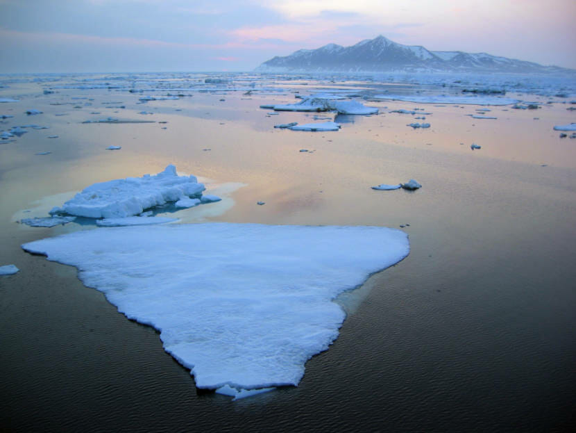
Sea ice floats in the Bering Strait off Cape Prince of Wales. (UAF photo by Gay Sheffield)
The 2020 Arctic Report Card is out, and the results show the Arctic continues to warm at an accelerated rate. This year was the second warmest on record in the Arctic, with impacts to sea ice, erosion and marine ecosystems.
In 2006, the National Oceanic and Atmospheric Administration released its first Arctic Report Card, laying out a timely snapshot of what the coldest parts of the world looked like as the climate warmed.
Rick Thoman is a climate specialist with the University of Alaska Fairbanks.
“Things were starting to change rapidly enough that folks were interested in this near-real time update of a variety of the different parts of the Arctic system,” Thoman said.
Fifteen years later, Thoman is the lead editor of the 2020 Arctic Report Card. He says even though Alaska didn’t have very extreme weather patterns, the Arctic as a whole was impacted.
“Some place in the Arctic every year has some extreme. It varies place to place,” Thoman said. “This year, Siberia, especially Western Siberia was the focus of the warmth, the very early snow melt, the wildfires, some of which were overwinter fires, zombie fires. Last year was Alaska. A couple years ago it was Greenland.”
Thoman says even though Alaska was impacted a little less this year by the warming climate, it still follows the recent trend.
“Whatever the trend is, there’s always going to be years above and years below that,” Thoman said. “We’re at the point now though, for instance with erosion, it wasn’t as much as last year, but it’s always going to be more than it was in the 1950s.”
One of the facets of the Arctic most impacted by a warming climate is sea ice. Thoman says this year followed a trend of shrinking sea ice in the Arctic.
“The lowest it got at any point was the second lowest [on record]. Only the 2012 minimum extent was lower,” Thoman said. “And in the winter, the maximum extent it got on any one day was the 12th lowest.”
Low sea ice extent impacts much of the arctic ecosystem, forcing marine mammals like walruses and seals to haul out on tiny patches of land rather than the thick rich sea ice they’d been accustomed to. Thoman says that bowhead whales in Alaska waters are in a slightly better position than other marine mammals, due to their ability to swim much farther to get to the zooplankton that they eat.
“If their food supply is very far north one year because that’s where the ice is, they have the ability to go and get that food, unlike other species which have a much shorter range,” Thoman said.
While that works well for the whales, Thoman says new feeding routes have the potential to upset subsistence whale harvests from Alaska’s northernmost Indigenous populations.
“From a whale perspective, if they have to go 600 miles of the Alaska coast to find food, for a bowhead that’s not a problem,” Thoman said. “At what point it becomes the whales are there but they’re not accessible for Alaskans, that’s a different question.”
Basically, Thoman says what was once abnormal or unusual in terms of Arctic climate is now normal. The Arctic is transforming, and populations will have to adapt.
Close
Update notification options
Subscribe to notifications
Subscribe
Get notifications about news related to the topics you care about. You can unsubscribe anytime.