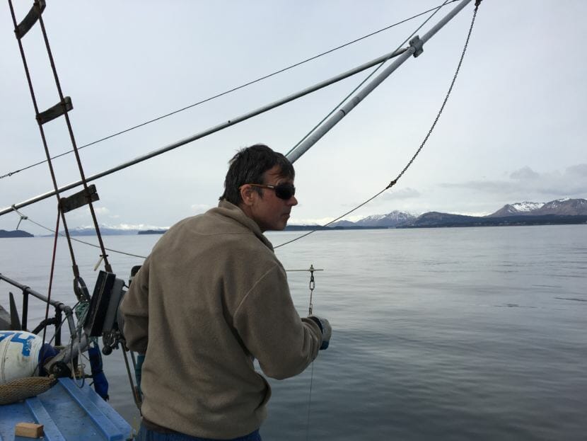
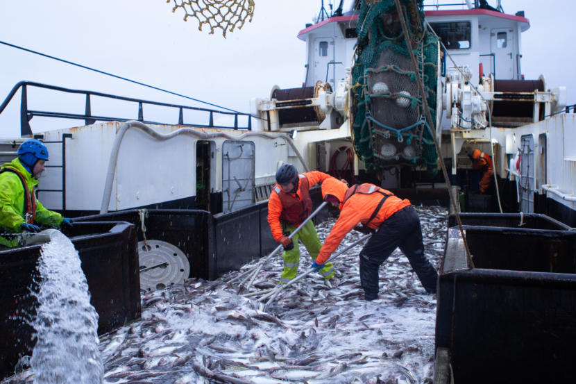
Fishing for cod in the Gulf of Alaska. (Annie Feidt/Alaska’s Energy Desk)
Tiny but mighty phytoplankton live at the base of the food chain in the Gulf of Alaska. They’re a food source for small crustaceans, which in turn feed small fish, then bigger fish, then seabirds and marine mammals.
Each spring and summer, a large concentration of phytoplankton blooms in the gulf. This year, researchers recorded the biggest bloom they’ve ever seen.
“Which theoretically means we should have a very productive year at a whole bunch of other steps in the food chain,” said Russ Hopcroft, a professor with the University of Alaska Fairbanks.
He said the phytoplankton bloom in itself is nothing out of the ordinary.
“Part of the natural cycle in the Gulf of Alaska is that when the light starts coming back in the spring and the storms start to subside a little bit, we get a big explosion of life in the phytoplankton,” he said.
Hopcroft said people on passing ships might not register the large amounts of phytoplankton, besides more activity from birds or fish in the area. But researchers keeping tabs on the blooms have noticed. They monitor the area each May, both with satellites and samples taken on a research vessel.
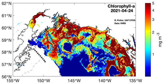
Chlorophyll levels in the Gulf of Alaska as measured by a satellite in April. (University of Alaska Fairbanks)
This year, the bloom spanned from Kayak Island near Cordova to Kodiak, dropping off where the gulf shelf plummets into deeper waters.
“I think we just had the right combination of some prolonged light and just enough storminess to keep things mixing a little bit, but not so much that they diluted and spread everything out,” Hopcroft said.
Climate may also play a role. The Gulf of Alaska saw a heat wave between 2014 and 2017, nicknamed “the Blob,” which decimated some commercial fish populations and changed the marine makeup of the gulf.
“There wasn’t much of a bloom during the Blob,” Hopcroft said.
But he said the gulf has seen more normal temperatures this year, at times even trending slightly cold.
Hopcroft said the hope is the energy from the phytoplankton make it up the food chain, from the fish that swim in the gulf’s waters all the way up to the Alaskans who eat them.
Right whales are so named because they were the “right” whale to hunt. They’re known for being slow-moving, and they float on the surface after being killed.
“It’s estimated that between 26,000 and 37,000 animals were taken in only a handful of decades,” said Jessica Crance, a Research Biologist at the Marine Mammal Lab at the Alaska Fisheries Science Center. “And then they became the target of illegal Soviet whaling in the 1960s. And that decimated what was left of the population and brought them down to what we think are their current numbers.”
According to National Oceanic and Atmospheric Administration scientists, there are about 30 members of the Eastern Group of North Pacific right whales left in the wild. They live in Alaska waters, and there are only a handful of sightings in a decade. But last month, survey vessels encountered two different groups of right whales, each with two different individuals. That may not sound like much, but those four whales make up over 10% of Alaska’s right whale population.
Both sightings occurred near Kodiak Island, with the first sighting being on the morning of Aug. 21 around the Barnabas Trough west of Kodiak Island. The second sighting was on the Aug. 24, near the Trinity Islands on the west end of Kodiak.
Crance witnessed both sightings personally, and is among a handful of living people who have seen one of this population of right whales up close since the species was devastated by commercial whaling.
According to her, NOAA biologists found the whales when they went looking for them.
“We had marine mammal observers that were looking for marine mammals from two different platforms. And the purpose of the survey was to get distribution density and abundance estimation for large whale species in the area. And so it was during the survey that we had two different sightings of North Pacific right whales,” she said.
She says right whales are easy to identify.
“When you’re looking at a right whale, they have a very pronounced V-shaped blow. So if you happen to see a distinctive V in the blow pattern, there’s a good chance you’re looking at a right whale,” she said.
While infrequent sightings make it difficult to gauge population trends, there is some good news. Two of the four whales spotted were completely new individuals, that until then had never been logged by researchers. The other two animals are known to biologists — one was seen nearby in 2006 and the other had been seen earlier this year off the coast of British Columbia.
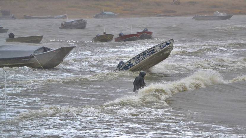
Storm surges against Toksook Bay on Oct. 1, 2015. (Photo by Jimmie Lincoln)
Western Alaska, a region already known for its high winds, is projected to get even windier. In communities along rivers or the coast, that could accelerate erosion through stronger waves. Driving these changes is a warming climate.
John Walsh is the chief scientist at the International Arctic Research Center at the University of Alaska Fairbanks. He wanted to see how the earth’s warming climate would affect wind speeds in Alaska.
“The message that came through pretty consistently, no matter what the criterion was, was that the Western Alaska region was the one where winds are expected to increase,” Walsh said.
In research he published in 2019, Walsh analyzed two climate models that project a 25% to 50% increase in high-wind storms in Western Alaska by the end of the century. He said that other climate models vary in how much they project wind speeds to change, but that they all show a significant increase.
Walsh said that the reason why Western Alaska is getting windier is that it will soon inherit the Aleutian Islands’ storms. In today’s climate, the Aleutian islands are the windiest area in Alaska.
“It’s the boundary zone between the cold climates and the warm climates,” Walsh said. “And the storms tend to feed off that contrast.”
But he said that boundary is on the move.
“As you warm the planet, you’re essentially expanding the tropics and shifting weather patterns to the north. So as all features get shifted to the north, that includes the storm tracks,” Walsh said.
As storms move north of the Aleutians, Walsh said that wind speeds would likely decrease in southern and Southeast Alaska.
Walsh said that while high winds brought by storms would become more frequent in Western Alaska, that doesn’t necessarily mean maximum wind speeds will increase. He also said that climate models show that high wind storms are most likely to increase during the winter months, between October and March. Projections show little change in wind speeds between late spring and early fall.
UAF climate scientist Rick Thoman, who was not involved in Walsh’s research, said that his colleague’s findings make sense. Thoman also said that if Walsh is correct that storms will move north, that would not just change wind speeds, but their direction.
“We’re gonna have more instances where instead of being in the northeast winds, there’ll be more times when we’re in the westerly or southwesterly winds part of the storm,” Thoman said. “That, of course, is very problematic for places on the immediate coast that have some version of westerly facing ocean. Places like Quinhagak, which already had terrible erosion problems.”
In another Western Alaska community, Napakiak’s riverbank is eroding three times faster than it was 10 years ago. Walsh’s research shows that wind speeds have already increased by 10% to 30% in the last 40 years.
Even the potential benefits of increased wind speeds are murky. The Alaska Village Electric Cooperative operates 30 wind turbines across Western Alaska. President and CEO Bill Stamm said that it’s difficult to tell whether high winds during storms would benefit wind turbines. For one, he said that AVEC’s wind turbines max out their energy generation once winds reach 30 miles per hour.
“If we’re already at the maximum output of the wind turbine, it doesn’t matter if the wind blows any harder,” Stamm said.
And if wind speeds reach 55 miles per hour, turbines shut down for safety reasons. Then they aren’t generating any power. Plus, Stamm said, some wind turbines just aren’t built to handle heavy storms on a consistent basis.
“If you have extreme wind events, you have to buy a certain turbine that’s going to be able to endure that. If we start shifting that bracket of what kind of wind a turbine can experience, we may have other problems,” Stamm said.
Climate scientist Thoman said that the projected changes in wind speeds are just one more example of drastic environmental changes that humans will have to contend with going forward.
“It’s more evidence to push us to prepare for things that we haven’t ever had to deal with before,” Thoman said.
Walsh said that his research’s projections for increased wind speeds are based on the assumption that humans continue to pump out greenhouse gases at their current rate. He said that the caveat is if humans mitigate their emissions, then the climate would not change as much and the predicted changes in wind speeds would be smaller.
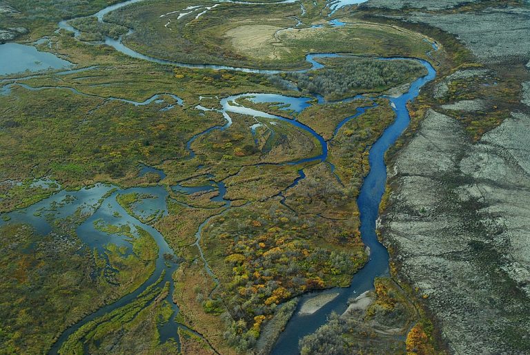
Aerial view of braided wetlands and tundra that is typical of the Bristol Bay watershed in Alaska, July 26, 2010. (Photo: U.S. Environmental Protection Agency)
The Environmental Protection Agency announced this morning that it will resume the process that could result in blocking the proposed Pebble gold mine at the headwaters of Bristol Bay.
“The Bristol Bay Watershed is an Alaskan treasure that underscores the critical value of clean water in America,” EPA Administrator Michael S. Regan said in the agency’s emailed statement. “Today’s announcement reinforces once again EPA’s commitment to making science-based decisions to protect our natural environment. What’s at stake is preventing pollution that would disproportionately impact Alaska Natives, and protecting a sustainable future for the most productive salmon fishery in North America.”
The announcement follows the success of mine opponents in a federal lawsuit. Environmental groups, Alaska Native organizations and fishermen sued to prevent the EPA from withdrawing the process begun under the Obama administration to “veto” the mine’s permit, using the Clean Water Act, specifically section 404(c). The Ninth Circuit Court of Appeals ruled that the government can only halt the process if it finds that depositing mined materials into a protected waterway would be “unlikely to have an unacceptable adverse effect.”
The case was sent back to the U.S. District Court, and the government’s response is due Friday.
“The agency believes the 2019 withdrawal notice did not meet the Ninth Circuit’s standard,” the EPA said in its announcement Thursday.
Assuming the judge in the case grants the EPA’s request to reverse course, the agency said it would resume the Obama administration’s effort to consider Clean Water Act protection for parts of the Bristol Bay watershed.
This is a developing story and will be updated when more information is available.
Crew members shovel pollock on the deck of the Commodore after a harvest on the Bering Sea in 2019. (Photo by Nat Herz / Alaska’s Energy Desk)
A high-seas legal fight is causing havoc for one of Alaska’s biggest commercial fisheries, the Bering Sea pollock harvest out of Dutch Harbor.
The quickly escalating saga involves hundreds of millions of dollars in fines, a miniature Canadian railway and Donald Trump’s personal lawyer and it stems from the way that one of Alaska’s biggest fishing companies, American Seafoods, is using an exemption in the federal law that typically allows only U.S. ships to move cargo between U.S. ports.
They’re challenging $46 million in fines issued directly to American Seafoods, plus more than $300 million levied against industry partners over the past month — some of which are holding American Seafoods’ subsidiary liable.
In legal filings, the companies say the threatened penalties are paralyzing the Alaska seafood industry’s supply chain to a port called Bayside, on the East Coast, and have stranded millions of pounds of frozen fish destined for American customers.
Crew members on the fishing vessel Commodore empty a trawl net of pollock on the Bering Sea. (Photo by Nat Herz / Alaska’s Energy Desk)
“Cargo vessels are no longer being sent to Bayside with seafood for the eastern United States. Fishing vessels returning from the Bering Sea to Dutch Harbor are facing dangerously tight conditions as the limited cold storage capacity fills up with cargo that was destined to the United States,” an Anchorage-based lawyer for the companies, David Gross, said in a court filing Tuesday. “The entire transportation route used by plaintiffs has been paralyzed and will be irreparably damaged, absent court intervention.”
Officials at the American subsidiary that filed the lawsuit, Alaska Reefer Management, declined to comment beyond a prepared statement. A Customs and Border Protection spokesman also declined to comment.
American Seafoods says it has the world’s largest operation processing $400 million worth of pollock each year, on its huge ships with onboard factories.
The company, like other major Alaska seafood players, sells much of its harvest to Asian and European markets.
But it is also a major supplier of pollock to U.S. customers, with products like fish sticks that end up at food banks and in school lunches. A little less than 15% of the company’s catch is shipped to the eastern U.S. on ships coordinated by Kloosterboer and American Seafoods’ shipping subsidiary, Alaska Reefer Management, according to court documents.
The Jones Act, a century-old federal law, typically requires American-flagged ships to move cargo between American ports. But the legislation contains an exception known as the “Third Proviso,” which allows companies to use foreign-flagged ships between U.S. ports if the routes include “Canadian rail lines” — and if they’re certified by an obscure federal agency called the Surface Transportation Board.
Alaska seafood companies have been using that exception since 2000, according to court documents.
Vessels flagged in countries like Singapore and the Bahamas first pick up frozen seafood products in Dutch Harbor, then travel to the Canadian port of Bayside, New Brunswick, just across the border from Maine.
From Bayside, the seafood would be trucked to a Canadian train, loaded and moved 20 miles between two stations — sometimes in the opposite direction of the U.S. border. Then the cargo would be loaded back onto the trucks to drive into the U.S.
In their court filings, the shippers say that both Customs and Border Protection and the Surface Transportation Board signed off on that practice, even though it was clear that the only purpose of the brief rail movement was to satisfy the requirements of the Jones Act. They also argue that they made customs officials aware of a new, even shorter rail line that they switched to using in 2012 to satisfy the Jones Act: a 100-foot stretch of track that’s entirely within the Bayside port.
“The trucks travel the length of the Canadian rail trackage and back,” Gross said.
The seafood products’ 200-foot train ride now appears likely to be at the core of the companies’ legal dispute with Customs BP.
Other companies with Bering Sea fishing vessels, including O’Hara Corp., Glacier Fish Co. and Arctic Storm Inc., also ship their seafood with Kloosteboer and the American Seafoods subsidiary. And in court documents, they say they face their own threatened fines from Customs and Border Protection.
In addition to Gross, Kloosterboer and the American Seafoods subsidiary have hired a high-profile New York-based law firm, Kasowitz Benson Torres, which has experience on Jones Act cases.
One of the firm’s partners working on the lawsuit, Marc Kasowitz, represented former President Donald Trump in the investigation into Russian interference in the 2016 election.
In their court filings, the companies say they were “completely blindsided” by what they call the “draconian penalties” proposed by Customs and Border Protection.
U.S. District Court Judge Sharon Gleason, in an order late Friday, granted the companies expedited consideration of their request for a temporary restraining order and preliminary injunction against the agency. If Gleason ultimately grants that request, Customs and Border Protection would be barred from penalizing the companies under the Jones Act for shipping more seafood while the lawsuit plays out.
Custom and Border Protection’s response is due next week.
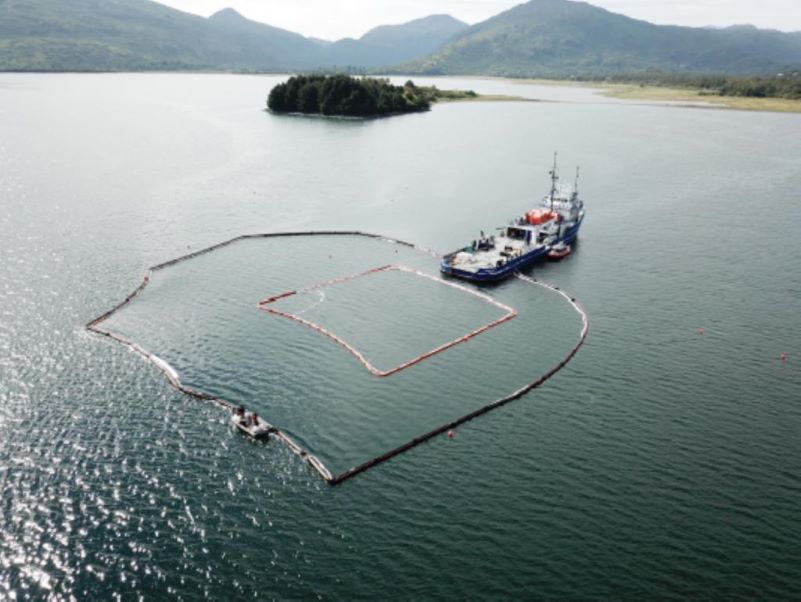
Responders put about 800-feet of boom around a sheen from the sunken ship in Kodiak’s Womens Bay on Aug. 14, 2021. (Photo courtesy of Global Diving and Salvage via Alaska DEC)
Efforts to contain pollution from a sunken scallop boat that sank off Kodiak Island more than 30 years ago have cost more than $3 million in less than a month. The wreckage of the Saint Patrick is a testament to one of Alaska’s deadliest fishing disasters, and it remains an environmental hazard today.
The Saint Patrick lay nearly forgotten at the bottom of Womens Bay until Aug. 3, when an alert passerby noticed an oily sheen on the water’s surface. Divers traced the leaks to several pinholes in the vessel’s hull, where the heads of rivets had corroded away over the past decades, state officials reported this week.
The state’s Spill Prevention and Response Division has been coordinating divers and boom deployment since oil sheens appeared in early August in Womens Bay. Responders say around 10,000 gallons of water mixed with petroleum have been removed.
“We’re making really good progress on removing fuels and this oily water from the vessel so that we can make sure that it doesn’t continue sheening,” Jade Gamble, who has been leading on-scene response, told CoastAlaska on Tuesday. “And we intend to get this vessel as clean as possible so that we don’t have to come back.”
Records are spotty on how the derelict Saint Patrick ended up on the seafloor. Officials only know it went down some time in 1989 after being moored nearby for several years.
“I’m not even for sure the date that it actually sunk,” she added.
But the story goes back several years earlier. And for many in Kodiak’s commercial fishing community, the vessel’s pollution has dragged up memories of one of Alaska’s most devastating fishing disasters, which claimed nine lives in 1981.
“It was a mismanaged boat to begin with,” recalled Bill Harrington, a retired commercial scallop fisherman in Kodiak. “You know that it was over 200 tons, so it’s supposed to have a licensed master mate and engineer. And then I know when it sank, the captain took the trip off and put this guy in charge that didn’t have a license.”
Owners paid out to survivors, victims in multi-million suit
Kodiak maritime attorney Jerry Markham represented one of the two survivors and several families of victims. He says just before the tragedy, the Coast Guard had let the 138-foot ship off with a verbal warning over the licensing issue.
But the owners ordered the Saint Patrick to fish for scallops anyway in late November.
“And the mate went out in a very serious storm and got side to the seas, and the boat rolled so far over that it took water into the air intakes and flooded the engine,” he said, “and that’s what caused the crew to panic.”
The fishing vessel Saint Patrick under tow in 1981 shortly after nine of the 11 crew perished after abandoning ship in rough weather. (Photo courtesy of Kodiak Maritime Museum via Alaska DEC)
The batteries had become waterlogged and someone in the crew became convinced they could explode. Which was unfounded. But that was the fear among the crew — most of whom had little experience on the water.
“They hired these kids out of Homer. A couple of them were under 20, as I recall, and they were for shuckers — that’s all their job was, was to shuck scallops. They didn’t know anything about maritime,” he said.
They were 13 miles offshore, when the order was given to abandon ship for a life raft. But it blew out of reach. Three of the crew members didn’t have survival suits, which in the frigid waters, gave them only minutes to live.
“The boys in survival suits, of course, they lasted 10 hours and watched each one of them slowly die until the last two got cast on different parts of the shore because they were separated,” he said.
Only two of the 11 crew survived after washing ashore on nearby Marmot Island. The disabled Saint Patrick rolled in the rough seas but never foundered.
“It’s just it’s such a tragedy because of the nature of the accident. If the boys that only stayed with the boat,” Marham said of the victims — eight of whom were men, one was a young woman.
The ship was salvaged a few days later and towed back to Womens Bay, where it remains today in about 58 feet of water.
As legal battle moved onshore, fishing vessel left to rust
Markham spent the next decade in litigation against the four principal owners of the Saint Patrick’s holding company.
“The court found the corporation was a shell and what we call piercing the corporate veil and held them all responsible for the accident,” he said.
It went to federal appeals twice before the court awarded a final payout of nearly $8 million to the two survivors and the estates of nine crew members lost in 1981. That wasn’t until the late 1980s. And during all that time, the abandoned Saint Patrick sat in Womens Bay.
“I wasn’t really concerned with the vessel. We were just looking at the situation, collecting something for the people,” he said.
Apparently nobody was. And the 200-odd ton ship rusted on its moorings while legal battles were fought onshore in federal court.
“The salver, I don’t know if he ever got anything out of it. But for this boat that nobody wanted to touch because it was, quote, a ghost ship,” Markham added.
Bill Harrington, who fished scallops all through the 1980s, remembers the empty Saint Patrick as a fixture on Womens Bay. It was visible from the road until one day in 1989, it wasn’t.
“It was kind of a reminder of the disaster that happened,” Harrington said. “You know, any boat isn’t going to stay afloat if no one’s taking care of it. And no one was taking care of that one, either. So that’s probably why it sank.”
Coast Guard, harbor officials say circumstances of 1989 sinking unclear
Kodiak’s harbor officials say there are no records explaining exactly when or why the ship went down.
Multi-beam sonar image of the bow aspect of the sunken vessel F/V Saint Patrick on Aug. 17, 2021. (Photo by eTrac Inc. via Alaska DEC)
Harbormaster Mike Sarnowski says he’s been calling around looking for answers and reading articles online.
“And nobody really has any information,” he said Wednesday. “So it’s a difficult story to find, but we’ll keep on trying to see if we can figure out if somebody here knows what actually caused the sinking in 1989 and Women’s Bay.”
Meanwhile, first responders are moving into their second month trying to contain any pollution from the sunken ship. The Coast Guard has tapped into federal cleanup funds with about $3 million in public money spent so far.
Efforts to track down those who could be held liable have been fruitless, says Jade Gamble, the on-scene coordinator.
“Many of the businesses that owned or were involved with this vessel in the ’80s are now out of business. And so there’s not been a responsible party identified as of yet,” she said.
Jerry Markham, the maritime lawyer, says he thought the Saint Patrick was a tragedy from another era. But he’s still answering questions about it.
“It’s crazy that they’re still having these problems with it,” he said. “But modern times have changed. Like I said, they’re much more concerned about the pollution these days.”
The ghost ship that claimed nine souls still casts a shadow of sorts over the waters of Womens Bay.
Hundreds of feet of boom encircle the area to keep the oily waste from reaching the shoreline. But this wrecked scallop boat that sank more than 30 years ago still isn’t completely at rest.
Close
Update notification options
Subscribe to notifications
Subscribe
Get notifications about news related to the topics you care about. You can unsubscribe anytime.